Dedicated to the 50th anniversary of Soviet power!
Report
On the first ascent of the combined team of climbers from the Novosibirsk Regional Council of the Union of Sports Societies and Organizations to the summit of Chimtarga (5487 m) via the Southwest wall, category 5B (approximately), in the Soviet Union's 1967 alpine climbing championship in the high-altitude technical climbing category. Team leader: L. Kaluzhsky. July 23–26, 1967. Fann Mountains. Pamir
Description of the Route and its Passage
On July 23, at 8:20 AM, the ascent began with an overnight stop under the wall.
Section R1 (Fig. 1, 2). The ascent up a snow-ice slope with rock outcrops takes about 3 hours. The slope's steepness ranges from 25° to 40°. Movement is in teams, simultaneous. The snow lies thinly on the ice, is heavily frozen, and thus requires frequent step cutting with an ice axe, especially on pure ice sections. We gain the first 300 m in height and reach the base of the rocks (Fig. 1). To the left, a very steep ice couloir ascends. A 5-meter vertical wall is overcome by free climbing (Section R1A). On a rock shelf, we assemble the first control cairn.
Section R2. Immediately presents maximum difficulty: a 40-meter vertical chimney filled with ice (Fig. 2, 3, 4). The chimney's walls are smooth, almost without cracks. Iosif Dobkin, wearing boots with a ridged sole, leads through this challenging section, using 7 pitons. The rest of the team must climb lightly and organize rope hauling for their backpacks.
Section R3. The next section is easier — a bend in the wall (Fig. 5), slightly snow-covered (15 m), followed by 15 meters of vertical, but dissected rock (3 pitons) (Fig. 3). Above, a narrow, inclined shelf, so smooth it seems polished. Tricams slip badly; those in boots with ridged soles fare better. We traverse right along the shelf (30 meters, 4 pitons). Valery Menshikov leads this and subsequent sections until the end of the day.
Section R4. From the shelf, we ascend difficult, vertical rocks along a narrow crack (40 meters). The first 4 meters are overhanging. Valery Menshikov climbs using the shoulders and head (another advantage of a helmet!) of Leonid Kaluzhsky. For the rest, he hangs a 10-meter ladder. Even with the ladder, climbing without backpacks is necessary. At the end of the rope, a small platform with a meter-high rock pillar of questionable stability awaits. Further, there are 15 meters of difficult but dissected rocks, followed by very difficult, vertical rocks with few holds (15 meters), requiring another backpack haul. Eleven pitons are placed in this section.
20:00. The bivouac site, though not ideal, is prepared on narrow, inclined slabs, 20 meters below the last rock step. We secure ourselves to anchor points and fit six into our "Pamirka" tent.
21:00 — a signal flare is launched, followed by a response from below and another from the Zindon ridge opposite, where another team of our Spartakovites is currently climbing an unascended peak.
On July 24, at the bivouac site, we assemble the II control cairn and begin movement at 11:20 AM. The late start today and the following days is due to the wall's exposure.
Section R5. From the last piton of the previous day, we ascend a section of rocks of medium difficulty: vertical walls alternating with dissected rocks. The team of Kaluzhsky and Meshkov leads (70 m, 5 pitons); the others follow with top-rope climbing.
Many loose rocks fall as we pull up the rope. We try to choose a route that provides cover for belay positions.
Section R6. We approach a monolithic wall. The only crack, which seemed simple from below, proves very difficult near up close (Fig. 6, 7, 8). This 40-meter vertical crack has very few places for pitons. Leonid Kaluzhsky uses a two-step ladder, and I. Meshkov hangs a 10-meter ladder for the others. We strive to avoid hauling backpacks, distributing the first climber's gear among the others' backpacks. This increases the pace but makes it harder for those with heavier loads. Only 6 pitons are placed in 40 meters.
Section R7. Above the crack, we organize a belay. Then, we traverse right (10 m, 2 pitons) along a narrow, debris-covered shelf and, balancing over a 1-kilometer drop, jump over another, wider crack. We ascend a steep (70°), narrow ridge for 30 meters (5 pitons) until we reach a vertical wall. Along this wall, we traverse 2–3 meters right to a small platform with a stream, enclosed by vertical rocks on three sides. Climbing remains very difficult.
Section R8. From the platform, we ascend a vertical 20-meter wall with a narrow crack (3 pitons). This is the last section of complex climbing for the day (Fig. 9). Again, we use a two-step ladder to overcome the final vertical section and reach Section R9 (Fig. 10): 80 meters (6 pitons) of inclined slabs, partially covered with debris, alternating with short walls.
For the first time that day, we feel less exposed. At the end of the section, we traverse a wide couloir (Fig. 10) and reach the boundary between the southwest and west walls. The height is about 5000 meters; below us lies the Chimtarga pass. The wall ahead drops vertically, offering no hope. A vertical wall with some overhanging sections lies directly above; a fairly wide crack runs through it, a very difficult but seemingly passable route. To the left, there are also sheer drops.
However, it's already 19:30, and the chosen platform requires significant preparation. For over an hour, secured to the rope, we engage in "house-building" — extracting rocks for a foundation and filling gaps with rubble (Fig. 11). Eventually, on the site of a sloping scree, we create a platform that can fully accommodate our tent.
At 21:00, another flare is launched, and a response follows promptly, indicating that we are likely visible from below.
On July 25, 1967, the platform is more comfortable than the previous night's, but sleep is restless due to strong winds tearing at the tent.
We assemble the III control cairn on the platform. We start moving at 12:00 PM; it's very cold and windy.
Section R10 (Fig. 2). We ascend a complex rock wall (5 m, 2 pitons) to the base of a vertical crack. The team of Kaluzhsky and Martynov processes the 70-meter section, which the others follow with top-rope climbing. This section is highly prone to rockfall (Fig. 12).
Section R11. Next, we traverse 60 meters of a gentler rock ridge, moving simultaneously with occasional belays on outcrops.
Finally, we reach the key section, a mystery until now.
Section R12 (Fig. 12) — a 150-meter "pink mirror" (Fig. 13). It has a tiled structure: the upper and lower parts, with a steepness of 60°, are separated by an overhanging eave. The rocks are smooth and monolithic, with very few cracks. There are few holds; we must rely on friction. V. A. Martynov leads, processing this section. While Martynov climbs the "mirror," Meshkov and Kaluzhsky take turns belaying and supplying pitons, ropes, etc. The rest prepare a hot breakfast. In the middle of the "mirror," we use ladders and hang a 10-meter ladder. Twelve pitons are placed. The ascent is initially vertical, then veers left towards a visible ridge that crowns the "mirror."
Section R13, "The Ridge," is also very complex and, unlike the "mirror," is littered with heavily destroyed, loose rocks. Two vertical walls, each 15 meters (6 pitons), are separated by tiny platforms that can barely fit two people, with no room for backpacks. We hang the backpacks on pitons. Again, we use a 10-meter ladder (Fig. 14).
Section R14. We traverse a similar loose rock section along a narrow shelf (20 m, 2 pitons) above the "mirror." The ridge indeed crowns it, and beneath our feet, apart from precarious footing, lie 150 meters of sheer rock. Below, others are still climbing, gathering the last rope and removing pitons. Further, there are 50 meters of vertical rocks. The shelf ends under a wide crack that leads, after 10 meters of unpleasant climbing, to a small, rock-strewn "balcony." Above the balcony, a 10-meter pointed rock (4 pitons) is followed by a small, cleared platform suitable for a bivouac.
On July 26, 1967, the night is again very restless; the wind tears at the tent, stretched over pitons, and the roof repeatedly hits out a drumbeat. The height is likely over 5200 meters, as Energy Peak is now below us.
We depart at 10:20 AM, leaving the IV control cairn as usual.
Expecting near-summmit snow or possibly ice, four team members don crampons, while two wear boots with ridged soles.
Section R15. From the bivouac, we ascend an initially straightforward ridge with a psychologically challenging traverse along a shelf and a 3-meter vertical wall, which requires climbing up to a platform. This balancing act occurs over the kilometer-high southwest wall, dropping sheer to the scree below Chimtarga pass. 40 meters, 3 pitons, and we reach another challenging section, R16 (Fig. 15) — a 30-meter vertical chimney with a plug, masterfully climbed by Iosif Dobkin, who is wearing light boots. Those following, in crampons, slide hopelessly and hang on their Prusik knots. Backpacks are pulled up again (Fig. 15a, 15b, 15c). Wind and cold complicate the climb.
And that's it; the wall difficulties are over. A heavily destroyed, dangerous ridge due to "live" rocks leads to the pre-summit.
Section R17 (Fig. 16). We ascend with alternating belays on outcrops, then across wide, snow-covered summit fields, gaining the final 50 meters in height (Fig. 16).
15:00. 5487 meters. We are on the summit of Chimtarga. Flares soar into the deep blue sky. We exchange notes in the cairn, leaving our own — a jubilee note. Before us, teams from the Kazakh Alpine Club had ascended via the 4B category route from the Mутные озёра (Mутные Lakes).
The descent begins on snow fields to the northern pre-summit, then down a 40-meter rock wall to the eastern snow slopes, and along them in a traverse to the lowest saddle in the meridional ridge. From there, we descend via snow slopes, a labyrinth of ice drops (following a stream), and scree into the Right Zindon valley. This is a classified route — category 2B.
By 20:30, we return to the assault camp.
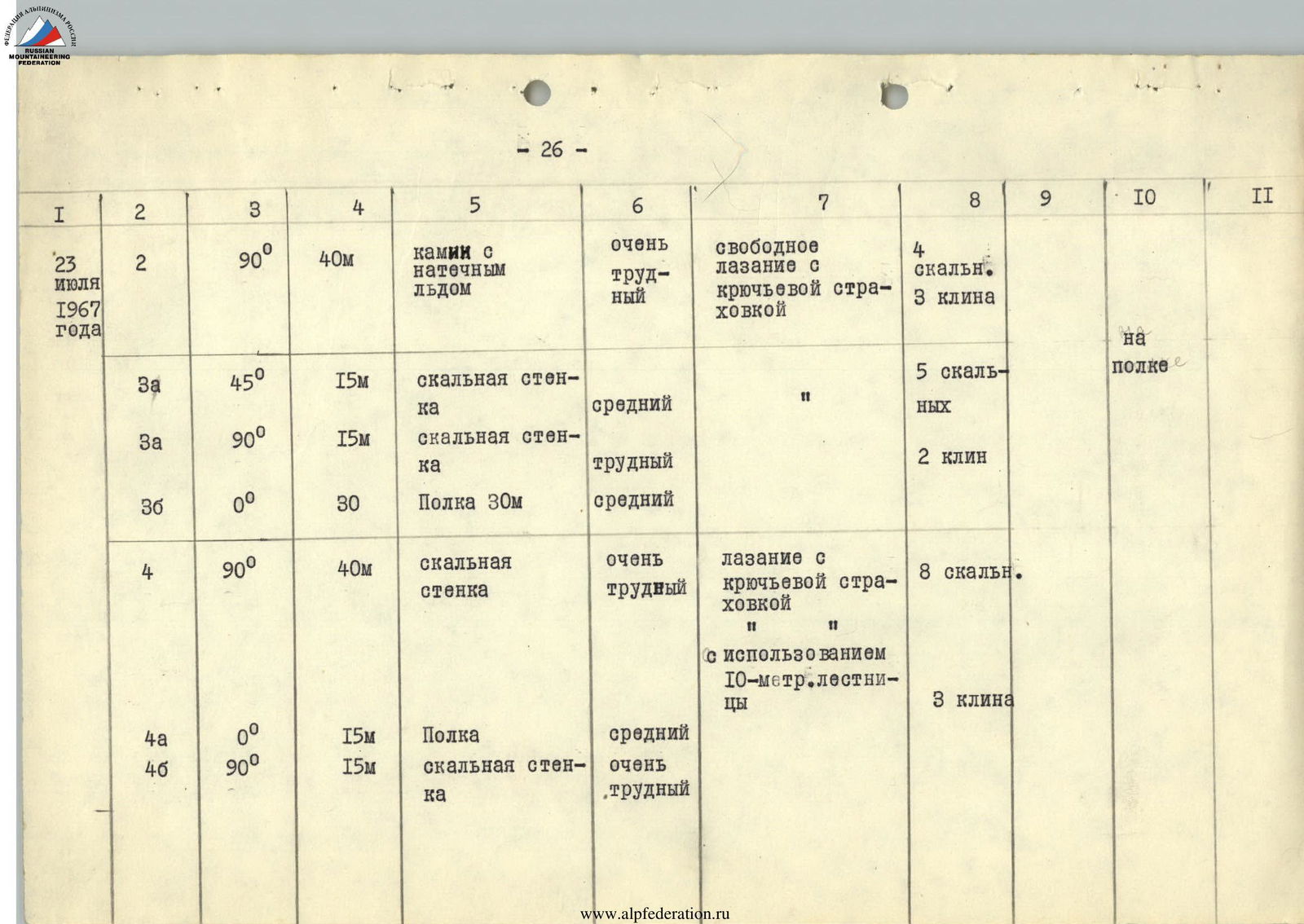
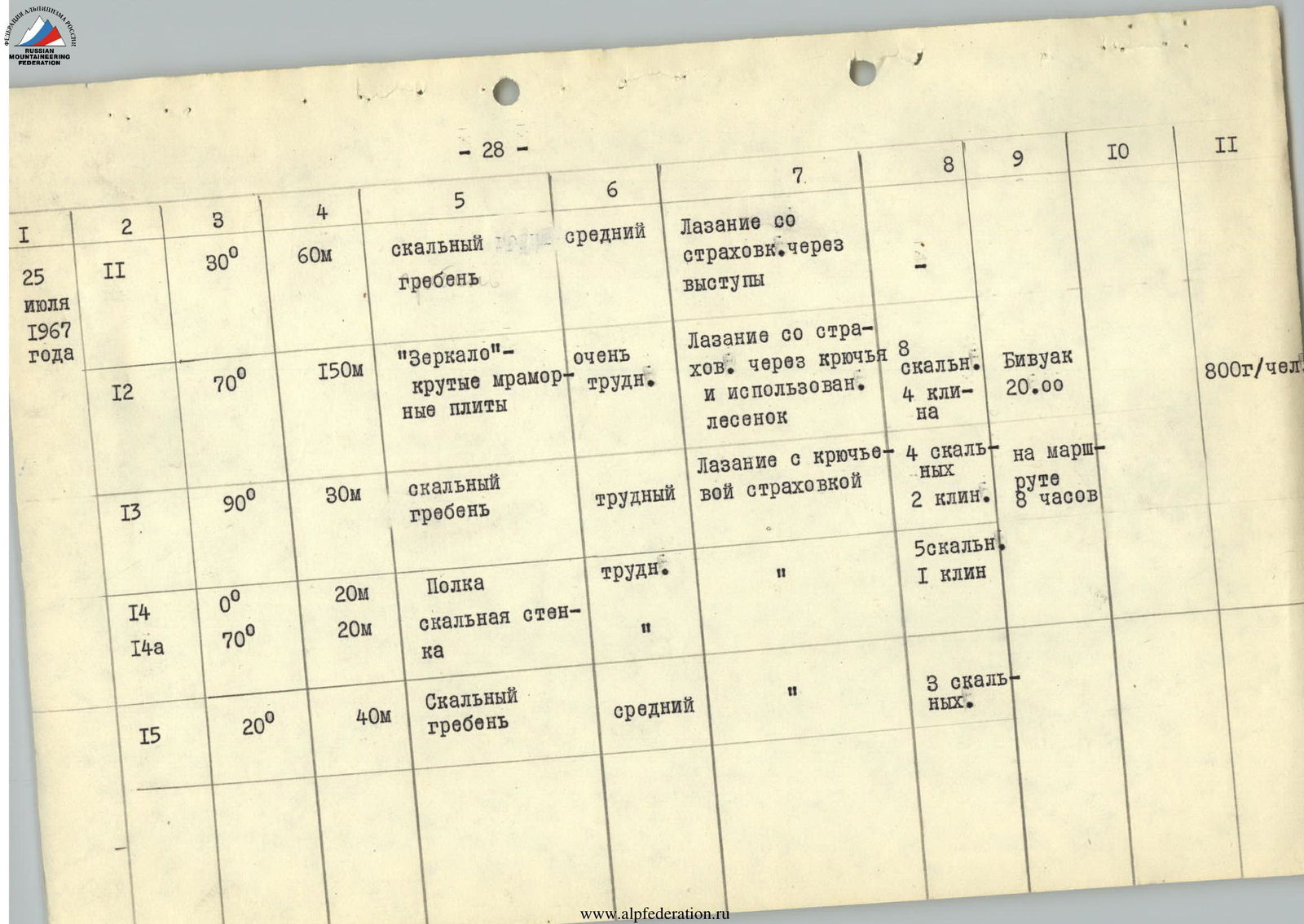
Table of Main Characteristics of the Ascent Route to Chimtarga Summit via the Southwest Wall
The wall section of the route is 1600 meters; the total route length is 2400 meters.
Height difference — 1100 meters. Including the most difficult sections — 400 meters.
Average steepness of the most difficult sections — 80°.
| Date | Section № | Average Steepness | Height Gain | Terrain Characteristics | Technical Difficulty | Climbing Method and Belay | Pitons Used | Time | Bivouac Conditions | Ration Weight |
|---|---|---|---|---|---|---|---|---|---|---|
| 1 | 2 | 3 | 4 | 5 | 6 | 7 | 8 | 9 | 10 | 11 |
| R1 | 35° | 600 m | snow-ice slope with rock islands | easy | in teams, simultaneous | departure 8:20 | ||||
| R1А | 90° | 10 m | rock wall | difficult | free climbing with piton belay | bivouac 20:20 on route 12 hours | in tent | 800 g/person | ||
| July 23, 1967 | R2 | 90° | 40 m | chimney with ice | very difficult | free climbing with piton belay | 4 rock, 3 ice | on ledge | ||
| R3a | 45° | 15 m | rock wall | medium | " | 5 rock | ||||
| R3a | 90° | 15 m | rock wall | difficult | 2 ice | |||||
| R3b | 0° | 30 m | shelf 30 m | medium | ||||||
| R4 | 90° | 40 m | rock wall | very difficult | climbing with piton belay and use of 10-m ladder | 8 rock | ||||
| R4a | 0° | 15 m | ledge | medium | 3 ice | |||||
| R4b | 90° | 15 m | rock wall | very difficult | ||||||
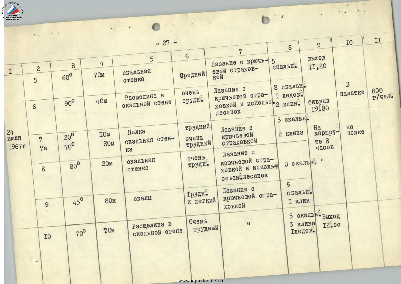
| July 24, 1967 | R5 | 60° | 70 m | rock wall | medium | climbing with piton belay | 5 rock | departure 11:20 | in tent | 800 g/person |
| R6 | 90° | 40 m | crack in rock wall | very difficult | climbing with piton belay and ladder use | 3 rock, 1 ice, 2 ice | bivouac 19:30 | on route 8 hours | ||
| R7 | 20° | 10 m | shelf | difficult | climbing with piton belay | 5 rock | ||||
| R7a | 70° | 30 m | rock wall | very difficult | 2 ice | |||||
| R8 | 80° | 20 m | rock wall | very difficult | climbing with piton belay and ladder use | 3 rock | ||||
| R9 | 45° | 80 m | rocks | difficult and easy | climbing with piton belay | 5 rock, 1 ice | ||||
| R10 | 70° | 70 m | crack in rock wall | very difficult | " | 5 rock, 3 ice, 1 ice | departure 12:00 | |||
| July 25, 1967 | R11 | 30° | 60 m | rock ridge | medium | climbing with belay on outcrops | ||||
| R12 | 70° | 150 m | "mirror" — steep marble slabs | very difficult | climbing with piton belay and ladder use | 8 rock, 4 ice | bivouac 20:00 | on route 8 hours | 800 g/person | |
| R13 | 90° | 30 m | rock ridge | difficult | climbing with piton belay | 4 rock, 2 ice | ||||
| R14 | 0° | 20 m | shelf | difficult | " | 5 rock, 1 ice | ||||
| R14a | 70° | 20 m | rock wall | " | " | |||||
| R15 | 20° | 40 m | rock ridge | medium | " | 3 rock | ||||
| July 26, 1967 | R16 | 90° | 30 m | chimney | very difficult | climbing with piton belay | 2 rock, 2 ice | departure 10:20 | ||
| R17 | 45° | 160 m | rock ridge | medium | climbing with belay on outcrops, simultaneous | summit 15:00 | on route 5 hours | 800 g/person | ||
| R17a | 0–30° | 800 m | snow fields | easy | descent 5 h 30 min | |||||
| Total | 57 rock, 25 ice, 2 ice | total on route 33 hours |
Team Captain, Master of Sports of the USSR (L. Kaluzhsky)
Team Coach, Master of Sports of the USSR (V. Martynov)

Fig. 2 Red "bastion" of Chimtarga's SW wall
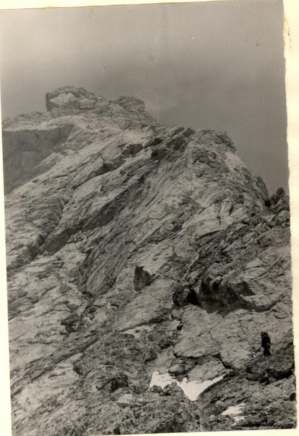
Fig. 12 Under the pink "mirror"