Ascent Passport
- Ascent category: High-altitude technical
- Ascent area: Pamir-Alai, Zarafshan Range, Fann Mountains
- Peak, its height, ascent route: Chimtarga, 5498 m, via the Eastern Counterfort
- Expected difficulty category: 4B category, combined
- Route description:
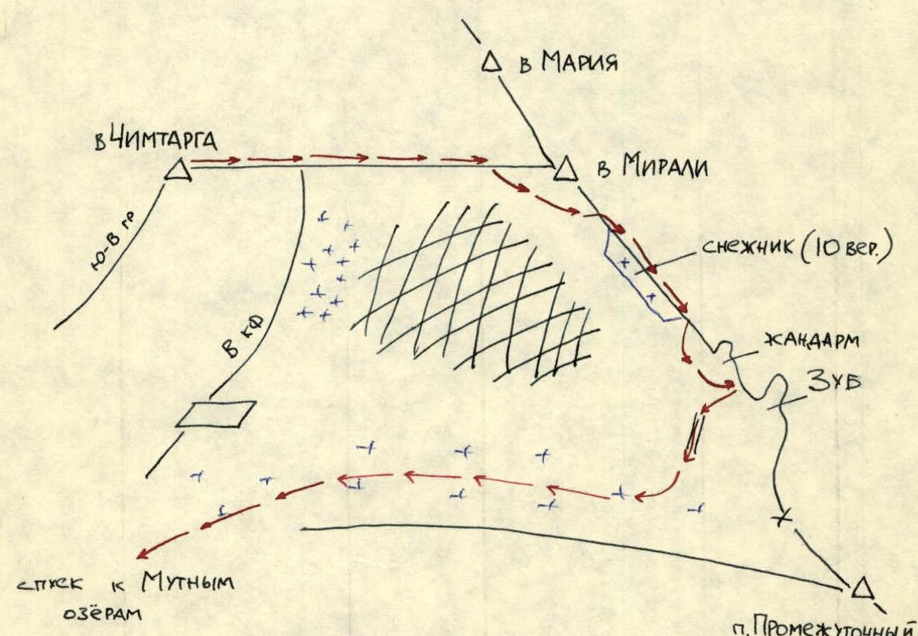
- Ridge height difference (by altimeter) – 1300 m
- On the ridge, there are 5 walls with a total height difference (10 m, 40 m, 25 m, 30 m, 40 m) – 145 m and an average steepness of 70°
- Length of sections:
- 5 km — 10 m
- 4 km — 150 m (4B) and 350 m (4A) with minimal mixed terrain (August)
- 3 km — approximately 900 m
- Mixed terrain on ascent — 30%, on descent — 90%.
- Number of pitons hammered and screwed into ice (for belaying, etc.):
- Rock pitons (including chocks) – 46
- Ice screws on ascent – 2, on descent – 9
- Total climbing hours: 18 hours
- Number of bivouacs and their characteristics: 1 lying-down bivouac
Surname, first name, patronymic of the leader, participants, and their qualifications:
- Mineev A.V. — 2nd sports category, leader
- Karpov E.V. — Candidate for Master of Sports, instructor 2nd category, cert. 1169
- Kotkin G.G. — 2nd sports category
- Ponomarev I.V. — 2nd sports category
- Bondarenko V.Yu. — 2nd sports category
- Bulashenko O.M. — 2nd sports category
- Petrov A.A. — 2nd sports category
- Pilipenko K.A. — 2nd sports category
Coaches: Karpov E.V. — Alpine section of MIPT sports club (first 6 people on the list), Dolgoprudny, Moscow region Mumdzhi T.M. — year-round alpine event at Fann Mountains CSP, Samarkand (last 2 on the list)
Departure date — August 8, 1986
Return date — August 9, 1986
6. Chimtarga

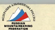
Approach
From the base camp near Kulikalon Lakes, cross Alaudin Pass to Alaudin Lakes, then follow the trail to Mутные ozera (Muddy Lakes). From Мутные ozera (see diagram), the SE ridge and glacier are visible; to the right of the glacier, a "rock massif" is visible, followed by scree and further to the right, a continuation of the rock above the "small" Muddy Lake. Ascend the scree (do not go onto the glacier!) and traverse the scree into the right gap between the "rock massif" and the rock above the "small" lake. Behind the scree, in the depths of the gap, there will be a glacier not visible from Мутные ozera – enter it from the right via the scree.
On the glacier tongue, there is a conical moraine where a tent can be set up. There is also a large, horizontal scree (or snow-covered) ledge, from which the route begins. The tent can be placed on this ledge under the route.
The ascent from Мутные ozera to the start of the route takes 1.5–2 hours.
Descent
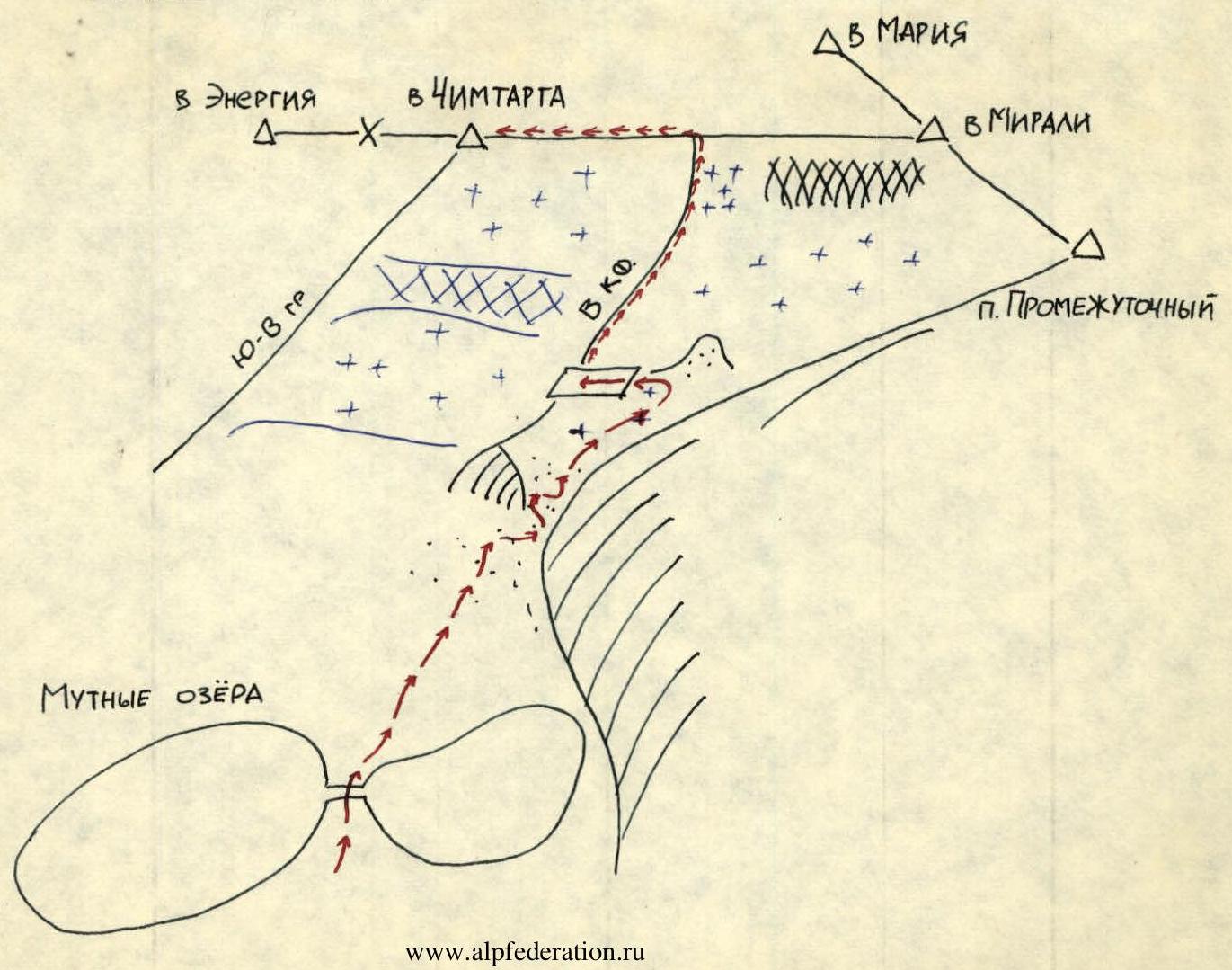
From Chimtarga peak, return to the bivouac site, descend via the snow-ice ascent route R16.
At the point where the Eastern Counterfort exits onto the ridge R15, immediately from the bivouac:
- rappel 40 m;
- traverse the snowy ridge under Mirali peak;
- bypass it on the right;
- exit onto the rocky ridge towards Promezhutochnyi peak.
Then:
- traverse the rocks to the snowy slope (see diagram) descending to the 10th notch;
- descend the slope to the rocks;
- bypass the "gendarme" on the right;
- reach the "Tooth".
From the base of the "Tooth":
- rappel 40 m to the snow on the ridge between Mirali peak and Promezhutochnyi peak.
Then:
- descend the snow in crampons to the bottom of the gorge;
- continue down the gorge past the start of the route;
- exit to Мутные ozera.
The descent from Chimtarga peak to Mirali peak takes 1.5–2 hours, and from Mirali peak to the start of the route — 2.5–3 hours.
Chimtarga Peak
Second Ascent of the Route
August 26–27, 1986, "Artuch" AUSB team consisting of:
- Pozdnyakov A.A. — Candidate for Master of Sports, instructor 2nd category, cert. 2884, leader
- Vorona S.M. — 2nd sports category
- Yashko K.A. — 2nd sports category
- Bereznoi A.E. — 2nd sports category
- Gavrilov I.V. — 2nd sports category
- Libinzon A.R. — 2nd sports category
Feedback and recommendations: All five walls encountered on the ridge are key sections; on two of them, rope pulling was performed for backpacks.
On the descent, after Mirali peak, the first 4 ropes were descended simultaneously on snow, then onto ice with an average steepness of 30°. On the ice, 2 ice screws were screwed in, 3 ropes were tied together, and a team member was lowered 120 m; then the rest quickly descended to him and set up a station on 2 ice screws. The last and second-to-last descended together: first, the second-to-last descended 10–30 m and screwed in an ice screw; then the last one approached him, and so on, until the entire group gathered at the lower station.
Below, the snow-ice slope turns left. The first team member was initially released 40 m, where he screwed in an ice screw, then traversed another 30 m — another ice screw. Immediately after that, the 2nd and 3rd team members approached the 1st and 2nd ice screws via the rope, to pass the knots, then the 1st traversed onto the rocks. The same procedure was performed earlier on section R16 (100 m of ice).
I believe the route corresponds to 4B category. A. Pozdnyakov
Third Ascent of the Route
August 28–29, "Artuch" AUSB team consisting of:
- Maksimenko L.S. — 1st sports category, leader
- Sorkin S.A. — 2nd sports category
- Khodyrev G.S. — 2nd sports category
- Filippov A.V. — 2nd sports category
- Burdin V.Ya. — 2nd sports category
- Otchik V.K. — Candidate for Master of Sports, instructor 2nd category, cert. 2101
Feedback and recommendations: The route corresponds to 4B in terms of difficulty (possibly 5A in other periods); it is desirable for the first climber to go completely unloaded. The route is quite tiring. Convenient in terms of orientation, safe regarding objective danger. V. Otchik