6B. 5B cat. diff. (Not on the paperwork) — to be credited as 6B 131
PASSPORT.
-
Technical class.
-
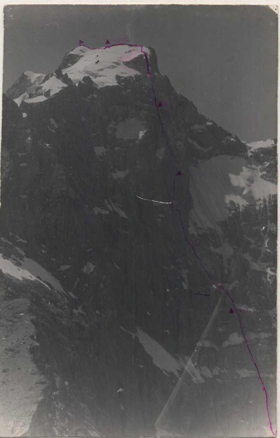
Pamir-Alay, Fann Mountains, Zeravshan Range.
-
Chapdara peak via the Northwest wall.
-
6B cat. diff.
-
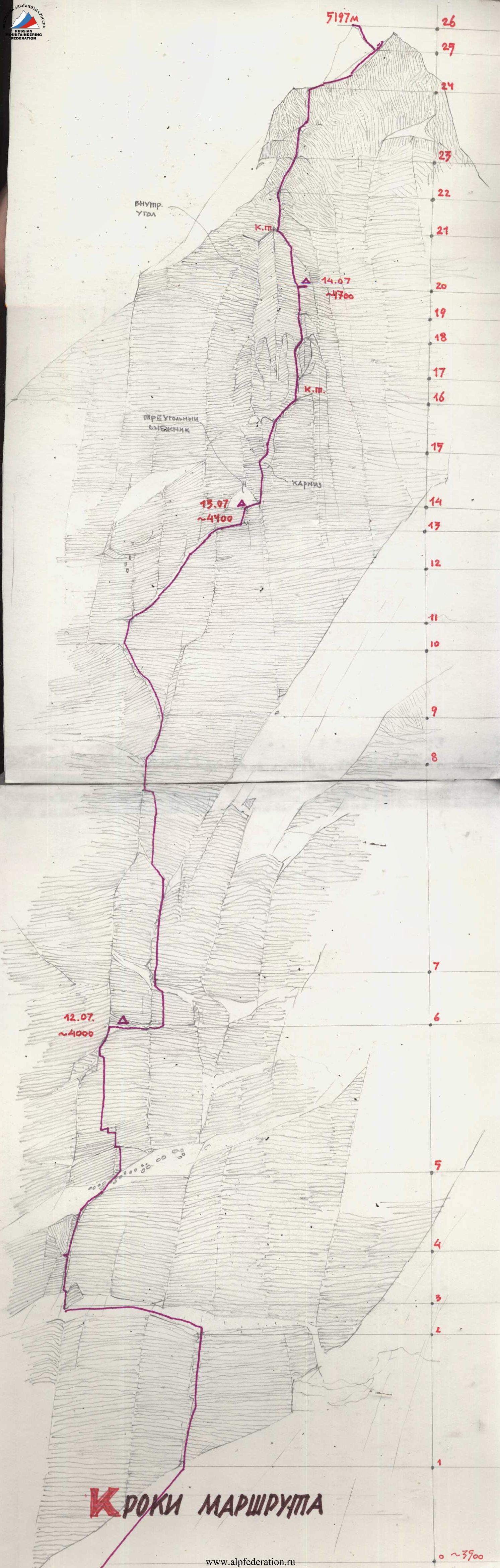
Height difference: 1500 m, length — 1870 m. Length of 6th grade sections — 380 m. Average steepness of the wall section of the route (3400–4940) — 70°
-
Use of protection points:
| rock pitons | bolt pitons | protection gear | ice screws |
|---|---|---|---|
| 184 | 11 | 355 | 28 |
| 15 | 1 | 22 | 0 |
-
44 hours of climbing and 5 days.
-
Overnight stops: 1 — lying, on a rock shelf cleared of ice. 2 — lying, on a shelf at the base of the "bird". 3 — lying, on a rock shelf.
-
Captain: Pechyonkin Mikhail Vladimirovich, Candidate Master of Sports. Team members: Krasnov Valery Anatolyevich, Candidate Master of Sports, 1st sports category, Kogtev Evgeny Alekseyevich, Candidate Master of Sports. Ivanov Vitaly Borisovich, Candidate Master of Sports.
-
Coach: Kurgin Sergey Nikolayevich, Master of Sports.
-
Departure to the route (processing) — July 15, 1990. Start of ascent — July 16, 1990. On the summit — July 19, 1990. Return — July 20, 1990.
-
Novosibirsk Alpine Club "SibAlp".
Route Program
Tactical Actions of the Team
On July 10, the first rope team, led by the team coach, approached the wall and began observing the route. The weather was bad — rain after lunch, occasional snow flurries. Low cloud cover made it impossible to survey the entire wall from bottom to top. On July 13, the second rope team arrived, and the team, gathered together, began a detailed observation of the route and discussion of tactics. The second variant of the tactical plan was unanimously adopted, as even in the lower part, there was fresh snow on the ledges.
On July 15, the Krasnov—Kogtev rope team, departing at 15:00, processed 3 ropes in the lower part. The rocks were wet, but it was possible to walk in galoshes.
On July 16, the team departed to the route in full force. The Pechyonkin—Krasnov rope team led the way. The rocks after a wide snow ledge were not very complex, but organizing protection points and installing rope railings presented significant difficulties. The weather deteriorated sharply after 14:00 — wet snow, strong wind. For two hours, they had to shelter under a film. They had already covered 12 ropes, but the pace of movement was lost; moreover, they needed to wait for the rocks to dry. They had to stop for the night.
July 17. They started working early, despite the icy rocks and cold. The wall was cold, the sun appeared after 14:00–15:00. But they needed to reach the base of the "bird" during the day. By lunchtime, they reached the "bird" and began processing to the right. By dark, they had installed 3 ropes on very complex rocks. This section could only be passed in the second half of the day when the sun melted the ice on the rocks. By evening, the weather deteriorated, and the rocks instantly "grew" with ice.
July 18. Everything repeated. After lunch, the weather worsened — snow, wind, low cloud cover. They passed rocks like "sheep's foreheads". It was very slippery and cold. They slowly approached the upper part. A large snow patch on the right served as a landmark. After the snow patch, they unexpectedly reached the overnight stop site. The Ivanov—Krasnov rope team went to process further. There were about 3 ropes left to the start of the inner corner. The entry to the corner was very complex — a heavily destroyed white marble zone with an overhang. Having processed two ropes, the rope team descended for the night.
July 19. They started very early. Fingers were numb with cold. Having passed 2 ropes on the railings, they warmed up a bit. The Ivanov—Pechyonkin rope team led the way. The team began to pass the overhanging marble zone. The rocks were heavily destroyed. Then they entered the inner corner. Here, in the middle, there was a wide crack. The rocks were monolithic, climbing was complex, all holds and ledges were covered with snow and ice. Protection points were inconvenient — semi-suspended. For protection, they had to drill in bolt pitons.
At 16:00, they passed the inner corner and reached the "tooth". Further, they traversed to the right. From the "tooth", they passed 4 ropes. Climbing was not complex, but there were many loose rocks, and sometimes sections covered with ice were encountered. Protection was combined — ice screws, channel protection, and placement protection. They reached the snow-ice ridge. Along it, they moved 160 m simultaneously. At 20:30, they were on the pre-summit ridge. It took 15 minutes to reach the summit. They left their backpacks, reached the summit, and returned. They would descend the next day. It was getting dark quickly; they set up a tent and spent the night.
On July 20, they descended. The descent presented no difficulties. The trail and rappel loops were clearly visible. By 13:00, they returned to the base camp.
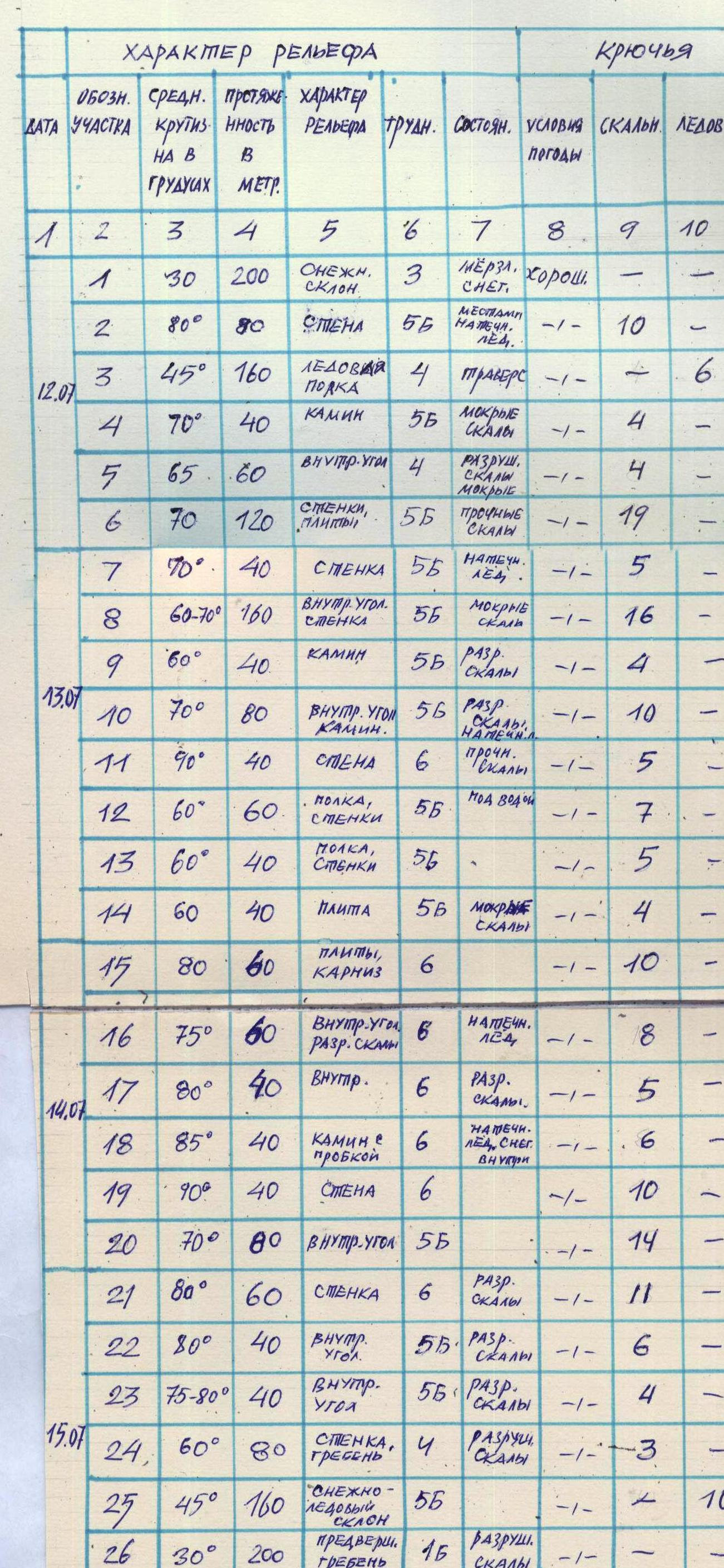
Table of Main Route Characteristics
 When passing the route, increased attention was paid to safety. To achieve this, the following measures were implemented:
- a) early departure to the wall, which excluded the possibility of the team being caught in a rockfall;
- b) the first climber moved on a double rope with a Saratovkin shock absorber;
- c) all railings were interconnected;
- d) movement on railings was done with top-rope protection;
- e) the available equipment allowed for the group's descent from any section of the route;
- f) the first-aid kit and radio station were in different backpacks; communication with the base camp and observers was maintained regularly (communication times: 10:00, 12:00, 16:00, 18:00, see radio communication log);
- g) the group's movement was monitored by observers located on the moraine under the route. The group extracted all pitons used on the route. Food waste and garbage were brought back to the base camp and disposed of there to protect the environment.
| SECTION DESIGNATION | AVERAGE STEEPNESS IN DEGREES | LENGTH IN METERS | RELIEF CHARACTER | DIFFICULTY | STATE | WEATHER CONDITIONS | ROCK PITONS | ICE SCREWS | BOLT PITONS |
|---|---|---|---|---|---|---|---|---|---|
| DATE | 1 | 2 | 3 | 4 | 5 | 6 | 7 | 8 | 9 |
| 1 | 30 | 200 | SNOW SLOPE | 3 | FROZEN SNOW | good | - | - | |
| 2 | 80 | 80 | WALL | 5B | VERGLAS | - | 10 | - | |
| 12.07. | 3 | 45 | 160 | ICE LEDGE | 4 | traverse | - | - | 6 |
| 4 | 70 | 40 | CHIMNEY | 5B | WET ROCKS | - | - | 4 | |
| 5 | 65 | 60 | INNER CORNER | 4 | BROKEN ROCKS | - | - | 4 | |
| 6 | 70 | 120 | WALLS, SLABS | 5B | SOLID ROCKS | - | 19 | - | |
| 7 | 70 | 40 | WALL | 5B | VERGLAS | - | 5 | - | |
| 8 | 60–70 | 160 | INNER CORNER, WALL | 5B | WET ROCKS | - | 16 | - | |
| 9 | 60 | 40 | CHIMNEY | 5B | BROKEN ROCKS | - | 4 | - | |
| 13.07. | 10 | 70 | 80 | INNER CORNER, CHIMNEY | 5B | BROKEN ROCKS, VERGLAS | - | 10 | - |
| 11 | 90 | 40 | WALL | 6 | SOLID ROCKS | - | 5 | - | |
| 12 | 60 | 60 | LEDGE, WALLS | 5B | UNDER WATER | - | 7 | - | |
| 13 | 60 | 40 | LEDGE, WALLS | 5B | - | - | 5 | - | |
| 14 | 60 | 40 | SLAB | 5B | WET ROCKS | - | 4 | - | |
| 15 | 80 | 60 | SLABS, EAVE | 6 | - | - | 10 | - | |
| 16 | 75 | 60 | INNER CORNER, BROKEN ROCKS | 6 | VERGLAS | - | 8 | - | |
| 14.07. | 17 | 80 | 40 | INNER CORNER | 6 | BROKEN ROCKS | - | 5 | - |
| 18 | 85 | 40 | CHIMNEY WITH STOPPER | 6 | VERGLAS, SNOW | - | 6 | - | |
| 19 | 90 | 40 | WALL | 6 | - | - | 10 | - | |
| 20 | 70 | 80 | INNER CORNER | 5B | - | - | 14 | - | |
| 21 | 80 | 60 | WALL | 6 | BROKEN ROCKS | - | 11 | - | |
| 22 | 80 | 40 | INNER CORNER | 5B | BROKEN ROCKS | - | 6 | - | |
| 23 | 75–80 | 40 | INNER CORNER | 5B | BROKEN ROCKS | - | 4 | - | |
| 15.07. | 24 | 60 | 80 | WALL, RIDGE | 4 | BROKEN ROCKS | - | 3 | - |
| 25 | 45 | 160 | SNOW-ICE SLOPE | 5B | - | - | 10 | - | |
| 26 | 30 | 200 | PRE-SUMMIT RIDGE | 4B | BROKEN ROCKS | - | - | - | |
| TOTAL: | 170 | 16 | |||||||
| 2040 |
NOTE: The number of pitons does NOT include the bolt revets on the route (sections 17, 18, 22) that were used.
Route Description by Sections
The route begins in the center of the wall above the snow "comma". From the "comma", an inclined inner corner leads — 50 m. To enter the inner corner, it is necessary to pass a rancleft, the length of which is 1–2 m. The rancleft is overcome along a snow bridge. The corner leads to an inclined slab — 50 m, section 1–2. Further along the slab to the right and upwards. The rocks are complex, and water flows over them.
On section 2–3 — broken rocks — 1st control point. Further, 40 m of simple broken rocks and exit to a large snow ledge, which approaches under a large broken inner corner, section 4–5. The rocks are passed with intermittent protection.
Next, there is an alternation of simple broken rocks with complex walls, section 5–7. Protection — through placement protection and pitons.
The broken rocks lead under an inner corner, 60 m long, which overhangs in the upper part. The corner is passed with free climbing.
Further — a broken inner corner, turning into slabs (rocks like "sheep's foreheads"), section 9–10. Here is a ledge where you can organize an overnight stay.
The "sheep's foreheads" lead under the base of the "bird" — a huge crack resembling a bird from afar. Here is the 2nd control point and a platform for an overnight stay — 1×2 m. The platform is covered from above by an eave.
Further movement is along the right wing of the "bird", representing an inner corner — a crack. There is snow and ice in the inner corner. It is possible to use an ice screw as protection.
After two ropes of climbing in the inner corner (section 10–11) — exit to a 0.5×0.5 m ledge. From here, to the right and upwards along a crack crossing a huge slab with a small number of holds. The crack leads to an inner corner filled with water in the evening and ice in the morning (section 12–13). To organize a reliable station in the inner corner, 2 bolt pitons had to be drilled.
Sections 11–12 and 12–13 are passed on artificial climbing holds (ITCH) using a friend as a handhold. The crack leads to a steep snow-ice ledge (section 13–14). Along the ledge to the right and upwards with the use of ice screws as protection.
After the ice — a chimney (section 15–16), leading to rocks like "sheep's foreheads" (section 16–17). Along the rocks upwards 40 m and exit to a 1×1.5 m ledge covered with snow. Here, an overnight stay is possible.
From the ledge straight up along inclined slabs — an approach to a wall with an eave. The wall is passed on ITCH (on skyhooks). The eave — fragile, crumbling rock — is passed by climbing with the help of a friend. It is difficult to organize a station behind the eave. For the station, a bolt piton was drilled.
After the eave, a huge inner corner begins (section 20–23) with black rocks in the middle (section 21–22). In the inner corner, holds are covered with snow and need to be cleared. The inner corner is passed by a combination of ITCH and free climbing. Friends are used for passage.
Section 21–22 — the "black belt" — is passed with free climbing. Climbing is complicated by snow and ice on the holds. The inner corner rests on a huge eave, which is bypassed on the left. When passing the corner, to ensure the reliability of the stations, one bolt piton was drilled at each station. An overnight stay is possible behind the inner corner.
Further upwards with a gradual traverse to the right — heavily destroyed rocks (section 23–24), leading to a chimney filled with ice. In the upper part of the chimney — a stopper. Further, a steep wall covered with a thin layer of ice. It leads to a snow-ice slope 80 m long (section 26–27). The slope is passed with the use of ice screws for protection.
Further along the ridge and the snow-ice summit tower — exit to the summit. Descent from the summit along the path of descent towards v. Zamok along the Southwest ridge.
