I. Category of technically challenging ascents
- Area of ascent: Fann Mountains.
- Chapdara, 5297 m, NW wall (Kiselev's route), category 5B, second ascent of the route.
- Route description:
route length — height difference — 2147 m, length of category 5 sections — 1700 m, average steepness — 70.
- Pitons driven:
rock — 103, ice — 36, chocks — 28.
- Number of climbing hours — 41 hours.
- Number of climbing days — 4, good bivouacs.
- Number and description of bivouacs: three bivouacs: 1st on a snowy slope, 2nd on a narrow rocky ledge, lying down, separate; 3rd on a rocky ledge, lying down.
- Team of the LGS DSO "Spartak".
- Captain: Razumov Yu.M. — CMS.
Kolchin A.A. — IMS. Kruglov E.M. — CMS. Gasilov E.F. — CMS.
II. Team coach: Kolchin A.A. — IMS.
- Date of departure from camp July 8, 1979.
Return to camp July 11, 1979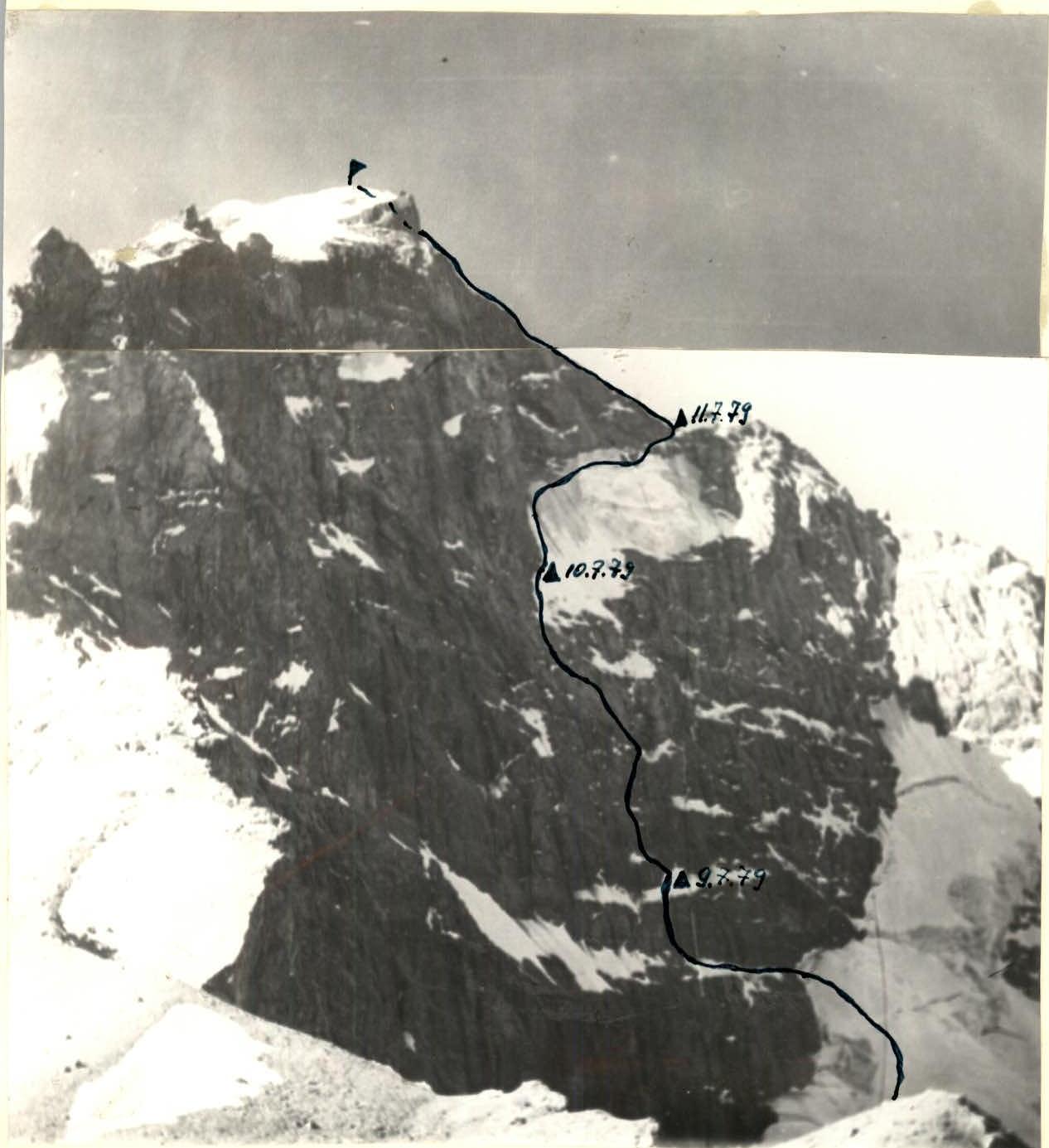
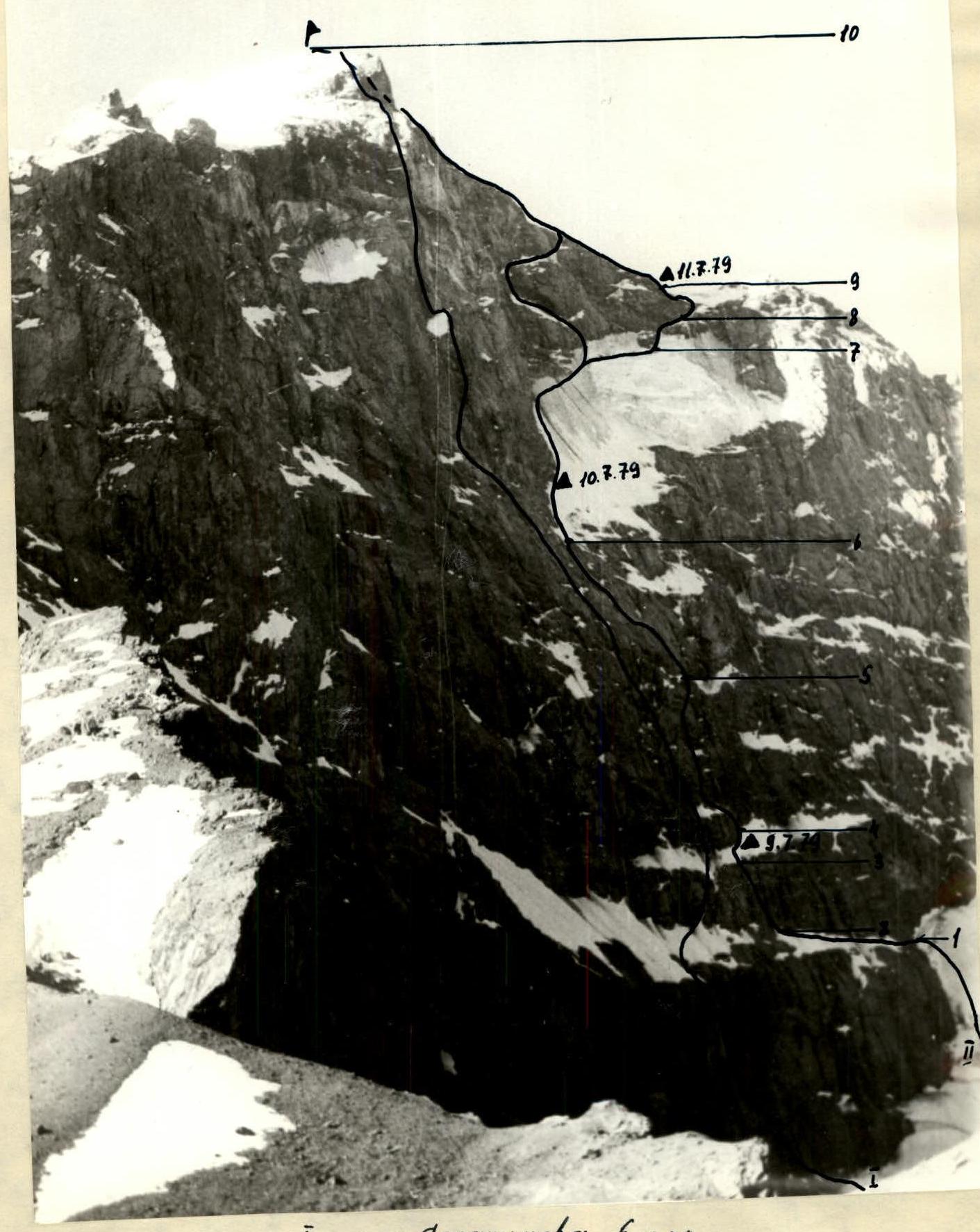
General view of the ascent route to Chapdara peak, 5297 m, via the northwestern wall category 5B, TABLE OF MAIN ROUTE CHARACTERISTICS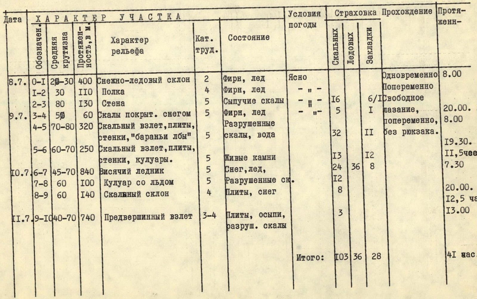
Brief explanations for the table of main route characteristics
The route via the northwestern wall of Chapdara was first climbed by a team from the ADK sports club of the CS DSO "Enbek" of the Kazakh SSR from August 10–20, 1965, led by Kiselev L. Since then, the route has not been repeated.
The approach from the Alaudin lakes to the northwestern wall of Chapdara takes 3 hours.
Section R0–R1. Snowy-icy slope of the Chapdara glacier is climbed simultaneously. Few crevices.
Section R1–R2. Along a ledge to the left. The ledge is initially scree, then covered with snow and flow ice. Movement is easy via a randkluft. Water flows from the wall. Overnight stay is possible in the randkluft.
Section R2–R3. From the ledge straight up to the next ledge, covered with snow, via a wall composed of characteristic rock with sharp edges for this area. Rocks are loose, many loose stones. Climbing is difficult, in places very difficult. The first person climbs without a backpack, in galoshes. Backpacks are pulled up.
Section R3–R4. After the wall, the rocks become gentler. In places covered with snow and ice. Ascent via snow to the next rocky ascent. Overnight stay under a cornice, leveling the site on snow.
Section R4–R5. From the bivouac to the right, bypassing the cornice, first via snow, and then via a rocky wall onto a small ledge. From the ledge via rocks, slightly overhanging in the lower part (using a stirrup), with the use of one ladder — exit under slabs. Via slabs to the right-upward (many loose stones!) to a rocky ridge, to the right a couloir, where stones fall.
Section R5–R6. Rocky ridge leads to a shoulder with many loose stones. From here to the left-upward, bypassing an overhanging wall. Then via rocks like "ram's foreheads" ascent to the right-upward under the base of an inclined snow-ice ledge with a hanging glacier.
Section R6–R7. We cross the couloir in its upper part. We move via snow under the rocks. Belay via rock pitons. The ledge is not very steep at the bottom, then becomes very steep. When passing in early July, it is 60% covered with snow, later it becomes very exposed. Ice is very dense, like flow ice. Regular crampons hold very poorly. Pitons are screwed in only when well-sharpened. When organizing an overnight stay in the lower part of the glacier, a note from the first ascenders was found. In the upper part, the glacier is very serious: it has to be crossed under the couloir, where small stones and ice fragments fall throughout the day.
In the bergschrund, in the upper part of the glacier, a good overnight stay can be organized. From it to the right, then upward via a steep ice ascent (flow ice) under a rocky couloir. This place is one of the most serious on the route. Ice pitons go in poorly, crampons do not hold. Section R7–R8.
Via the couloir to the right-upward. The couloir is filled with flow ice, many loose stones. Section R8–R9.
From the couloir, first to the right-upward, then to the left-upward via a snowy slope, we exit onto the pre-summit ridge with scree fields-slopes. Section R9–R10.
Via scree slopes and small rocky outcrops — ascent to the summit.
Recommendations for passing the route
In the lower part of the route, we recommend starting movement significantly to the left of the couloirs leading from under the hanging glacier, as stones fall through them almost throughout the day. At times, for safety purposes, it is advisable to exit onto the category 6B route, which runs parallel to Kiselev's route.
In the middle part, in the area of exiting onto the hanging glacier, the route is heavily hit by stones from above, there are few places for shelter. The largest number of stones falls:
- In the morning around 10:00–12:00, when the summit starts to be lit by the sun
- In the evening around 18:00–20:00 during sunset
The hanging glacier is also hit by stones, especially at first (first 4–5 ropes) and in the upper part. In the upper part, it has to be crossed under fire from stones and ice fragments. This place contains a couloir — a collector of stones falling from the summit tower. Therefore, we recommend here:
- Moving sharply to the right to the bergschrund,
- Under the cover of its overhanging upper edge, traversing the hanging glacier to the right-upward,
- Then exiting upward onto the ridge.
This variant of exiting onto the ridge is more complex, but less dangerous.
Members of the group were on the northwestern wall of Chapdara three times during the 1979 season; observations of the route allow us to conclude that the most suitable time for its passage is the first half of summer. Later, with abundant snowmelt, the number of:
- "Loose" stones,
- spontaneously falling stones, increases sharply.
Although the route, by its complexity, deserves to be a control-test route of category 5B, we propose to exclude it from the list of control-test routes, so as not to encourage the passage of an objectively dangerous route.