PASSPORT
I. Technical class.
-
Fann Mountains. Zeravshan ridge (Northern part). Alaudin lakes.
-
Chapdara peak (5050 m) via Eastern edge.
-
Category 5B (Cherevko route).
-
Elevation gain: about 1800 m. Route length 2875 m.
Length of sections with U–U1 difficulty: 564 m. Average slope of the route — 57°. Average slope of the wall section — 62°.
- Pitons hammered:
rock 101 (2 used), bolted 6, chocks 154 (6 used), ice screws 3.
- Team's total climbing hours: 29 hours, 3 days.
- Overnight stays: 1st and 2nd — lying on a ledge in a tent.
- Team leader — Spiridonov Alexander Semenovich — Candidate Master of Sports.
Team members:
- Chumakov Sergey Borisovich — 1st sports category.
- Eritenko Alexey Nikolaevich — 1st sports category.
- Petyanshev Vasily Nikolaevich — 1st sports category.
- Shapovalov Vitaly Anatolyevich — 1st sports category.
- Chumakin Evgeny Romanovich — 1st sports category.
- Coach — Shamraevsky Yuri Mikhailovich.
- Approach to the route: July 24, 1987.
Summit: July 26, 1987. Return: July 26, 1987. 12. Committee for Physical Culture and Sports of the Rostov-on-Don Regional Executive Committee.
Table
of main characteristics of the ascent route to Chapdara peak via North wall
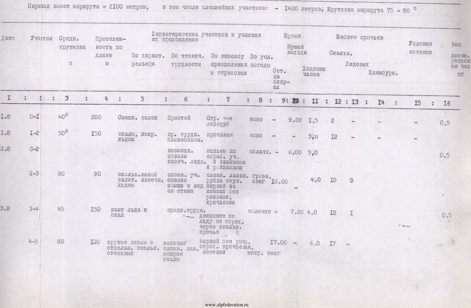
Elevation gain of the route — 2100 m, including the most difficult sections — 1400 m. Slope of the route 75–80°.
| Dates | Sections | Avg. slope, ° | Length, m | Section characteristics and conditions: By relief | Section characteristics and conditions: By technical difficulty | Section characteristics and conditions: By overcoming method and belay | Weather | Departure time | Climbing hours | Pitons hammered: Rock | Pitons hammered: Ice | Pitons hammered: Bolted | Overnight stay conditions | Daily ration weight per person, kg | |
|---|---|---|---|---|---|---|---|---|---|---|---|---|---|---|---|
| 1.8 | R0–R1 | 40 | 200 | Snow slope | Easy | Belay through ice axe | clear | 9:00 | 1,5 | 2 | 0,5 | ||||
| 1.8 | R1–R2 | 50 | 150 | rocks covered with ice | medium difficulty. Rockfall hazard. | piton belay | clear | 3,0 | 12 | ||||||
| 2.8 | R0–R2 | possible avalanches, hanging glaciers | ascent on processed sections with clamps and backpacks | cloudy | 6:00 | 5,0 | 0,5 | ||||||||
| R2–R3 | 80 | 90 | rock groove, filled with ice | difficult sections, rocks and ice falling from the wall | difficult climbing, step cutting, first on crampons without backpack, piton belay | thunderstorm, snow | 16:00 | 4,0 | 18 | 3 | |||||
| 3.8 | R3–R4 | 45 | 150 | ice and rock ridge | medium difficulty | movement on ice with belay through rock pitons | cloudy | 7:00 | 4,0 | 12 | 1 | 0,5 | |||
| 4-5 | R4–R5 | 80 | 120 | steep rocks with individual rock walls | difficult climbing, wet rocks | first without backpack, piton belay, ladders | wet snow | 17:00 | 6,0 | 17 | |||||
| 4.8 | R5–R6 | 85 | 120 | wall with few holds | difficult rocks, cornices | first without backpack, ladders, sometimes backpacks are pulled up | cloudy | 7:00 | 6,0 | 20 | 0,5 | ||||
| R6–R7 | 80 | 120 | series of rock walls, going in steps | sometimes ice on rocks, artificial holds | first without backpack, backpacks are pulled up | clear | 20:00 | 7,0 | 21 | 1 | |||||
| 5.8 | R7–R8 | 70 | 120 | rock slabs with walls | many "live" rocks | free climbing, piton belay, first without backpack | cloudy | 7:00 | 5,0 | 14 | 0,5 | ||||
| R8–R9 | 200 | wall with few holds, exit on slabs under overhang | holds of small size, rockfall hazard from the left | difficult free climbing, backpacks are pulled up | cloudy | 19:00 | 7,0 | 29 | |||||||
| 6.8 | R9–R10 | 90 | 120 | slab under overhang, exit to the top of the wall | one of the most difficult sections, overhang, ice | cloudy | 8:00 | 6,0 | 18 | 0,5 | |||||
| R10–R11 | 40 | 250 | snow slope in the upper part, ice | avalanche hazard in the lower part | alternating movement, belay through ice axe | thunderstorm, snow | 16:00 | 3,0 | |||||||
| 7.8 | R11–R12 | 60 | 120 | exit to the pre-summit ridge | rocks covered with ice | first without backpack | clear | 7:00 | 3,0 | 12 | 2 | 0,5 | |||
| R12–R13 | 30 | 200 | ridge | medium difficulty | alternating movement, belay through outcrops | clear | 2,0 | 4 | |||||||
| R13–R14 | 30 | 200 | snow-ice ridge | easy | simultaneous movement | cloudy | 1,0 | ||||||||
| R14–R15 | 40 | 350 | ice crevasse, snow-ice slope, pre-summit ridge | section of the route on NW edge, 5th category of difficulty | alternating movement in the lower part of the section | cloudy, sometimes snow | 2,0 | 2 | |||||||
| Total: | 65,5 | 179 | 5 | 1 |
List:
- I
- 2
- 3
- 4
- 5
- 6
- 7
- 8
- 9
- 10
- II
- 12
- 13
- 14
- 15
- 16
| 4.8 5-6 | 85 | 120 — wall with few holds | difficult rocks — cornices | First without backpack, ladders, sometimes backpacks are pulled up | Cloudy | 7:00 | 6,0 | 20 | 0,5 | |||
|---|---|---|---|---|---|---|---|---|---|---|---|---|
| 6-7 | 80 | 120 series of rock walls, going in steps | Sometimes ice on rocks, artificial holds | Pulled up, first without backpack, backpacks are pulled up | Clear | 20:00 | - | 7,0 | 21 | 1 | ||
| 5.8 7-8 | 70 | 120 rock slabs with walls | Many "live" rocks | Free climbing, piton belay, first without backpack | Cloudy | 7:00 | 5,0 | 14 | 0,5 | |||
| 8-9 | 200 wall with few holds, exit on slabs under overhang |
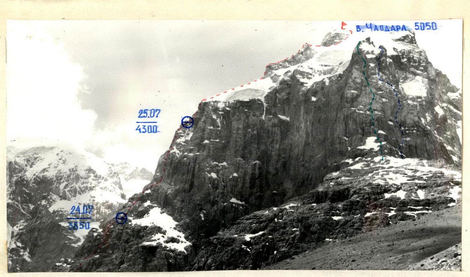
Photo 1. General photo of CHAPDARA peak. July 19, 1987, 11:00. "Zenitar" lens. Focal length 50 mm. Shooting height 3800 m. Shooting point 3. Distance to the object 500 m.
— Route of Rostovoblast committee team. — Popov's route, category 5B. — Route through "Sphinx", category 5B.
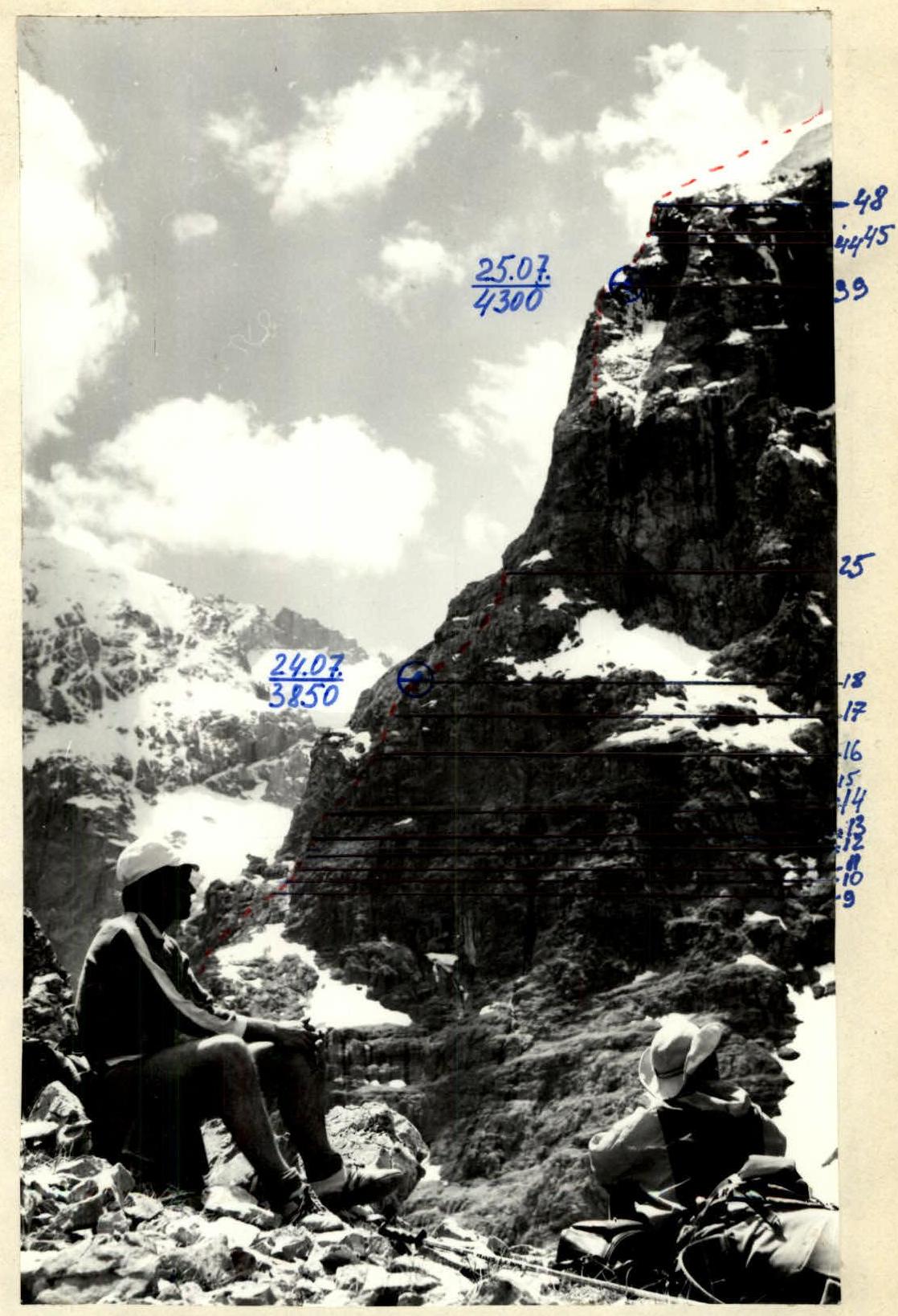
Photo # 2. Wall profile on the right. July 19, 1987, 12:30. "Zenitar" lens, focal length 50 mm. Distance to the object 300 m. Shooting point 2. Shooting height 3500 m.
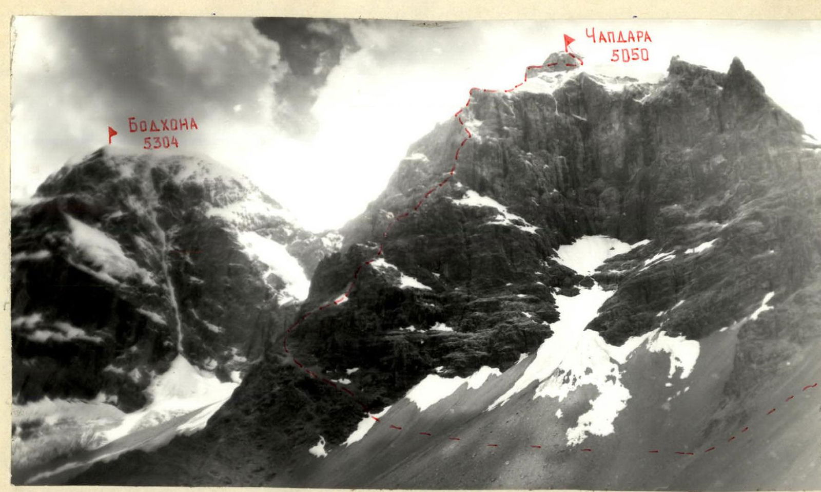
Photo 3. Photopanorama of the area. July 19, 1987, 14:00. "Horizon" T-28 camera. Focal length 28 mm. Shooting height 3200 m. Distance to the object 800 m. Shooting point 4.
Tactical actions of the team
The team did not deviate from the tactical plan, the route was completed according to the tactical plan. The organization of the rope teams' movement, their interaction, and the change of leaders by sections are specified in the tactical plan.
The first climber worked on a double rope, one of which was UIAA, without a backpack. The other participants moved on fixed ropes with top belay or on double fixed ropes with a Prusik knot (two jumar devices).
Sections that were impassable by free climbing, wet and icy rock sections were overcome using pitons with étriers and ladders for étriers.
As a belay point, a station consisting of at least three pitons (chocks) linked by a load-equalizing loop was used.
The movement regime is indicated in the team's tactical plan.
Overnight stays were organized in both cases in a lying position, under overhangs in a tent. Team nutrition: hot meals in the morning and evening. During the climb, each rope team had dry rations. In addition, to quench thirst, each rope team had dried fruits in the form of prunes.
There were no working falls, injuries, or frostbite.
The critical sections of the route were:
- the gap on section R36–R37, which was passed using artificial aids.
- the snow-covered smooth slab, section R44–R45.
It was climbed using pitons with étriers and ladders for étriers. Throughout the entire route, the group used a braking device for belaying the first climber.
Physical fitness allowed the team to complete the route with a large reserve in conditions of unstable weather. Technical preparation corresponded to the route climbed.
In bad weather, the team acted in an organized and cohesive manner.
To monitor the group and ensure radio communication, a tent for observers was set up at the Tolbas site. The observers had:
- a radio station,
- a spyglass,
- a photograph of the route,
- a tactical plan,
- a diagram in UIAA symbols.
The third radio station was located in the base camp.
There were no radio communication lapses.
The rescue team was located in the base camp.
TABLE OF FOOD SUPPLIES
| # | Name | Weight |
|---|---|---|
| 1. | Sugar | 1,5 |
| 2. | Honey | 0,5 |
| 3. | Nuts | 0,5 |
| 4. | Prunes | 1,0 |
| 5. | Crackers | 2,0 |
| 6. | Sausage | 2,5 |
| 7. | Meat broth | 0,72 |
| 8. | Chocolate | 0,6 |
| 9. | Tea | 0,2 |
| 10. | Cookies | 0,5 |
| 11. | Candies | 2,0 |
| Total: | 12,2 |
The group was provisioned with food at a rate of 0.677 kg per person. In addition, in case of "sitting out" due to bad weather, the group had an emergency supply in the form of freeze-dried soups — 0.72 kg, at 100 g/day:
broth cubes — 0.2 kg, chocolate — 0.2 kg.
Total weight of food supplies: 13.32 kg.
| 1 | 2 | 3 | 4 | 5 | 6 | 7 | 8 | 9 |
|---|---|---|---|---|---|---|---|---|
| 2 | R25 | R42–R43 | 10 | 70 | 5 | |||
| 3 | R41–R42 | 15 | 60 | 5 | ||||
| R40–R41 | 30 | 30 | 3 | |||||
| 2 | 1 | R24 | R39–R40 | 10 | 65 | 2 | ||
| 3 | 7 | R38–R39 | 40 | 60 | 4 | |||
| R23 | ||||||||
| 4 | 5 | R37–R38 | 30 | 75 | 5 | |||
| 5/4 | R22 | R36–R37 | 6 | 75 | 6 | |||
| 3 | 5 | R35–R36 | 30 | 60 | 4 | |||
| R21 | ||||||||
| 3 | 8 | R34–R35 | 40 | 50 | 4 | |||
| 4 | 2 | R20 | R33–R34 | 30 | 40 | 4 | ||
| 2/1 | 2 | R32–R33 | 8 | 80 | 6 | |||
| R19 | ||||||||
| 2 | 4 | R31–R32 | 35 | 70 | 4 | |||
| R30–R31 | 5 | 100 | 5 | |||||
| 3 | R29–R30 | 15 | 85 | 2 | ||||
| 2/1 | 1 | R18 | R28–R29 | 5 | 100 | 5 | ||
| 3 | 4 | R27–R28 | 25 | 70 | 5 | |||
| R17 | ||||||||
| 6 | 5 | R26–R27 | 40 | 70 | 5 | |||
| R25–R26 | 15 | 65 | 5 | |||||
| 2 | 3 | R16 | R24–R25 | 40 | 40 | 3 | ||
| 37 | 70/2 | July 24, 4:08 | ||||||
| 3 | 3 | R15 | R23–R24 | 10 | 65 | 5 | ||
| R14 | ||||||||
| 1 | 6 | R22–R23 | 70 | 40 | 3 |
| 1 | 2 | 3 | 4 | 5 | 6 | 7 | 8 | 9 |
|---|---|---|---|---|---|---|---|---|
| 10/2 | 3 | 6 | 159/6 | Total climbing hours — 29 | ||||
| 10 | 3 | 5 | 10 | July 26. Climbing hours — 9 | ||||
| R53–R54 | 800 | 30 | 2 | |||||
| R34 | ||||||||
| 2 | 3 | 2 | R33 | R52–R53 | 120 | 30 | 3 | |
| R32 | ||||||||
| 3 | 1 | R31 | R51–R52 | 35 | 45 | 3 | ||
| 3 | 3 | R30 | R50–R51 | 20 | 50 | 4 | ||
| 2 | 1 | R49–R50 | 15 | 65 | 4 | |||
| R48–R49 | 400 | 30 | 2 | |||||
| 3 | 2 | 3 | R29 | R47–R48 | 25 | 80 | 5 | |
| 5/2 | 1 | 74/4 | July 25. Climbing hours — 12. | |||||
| 6 | 3 | R28 | R46–R47 | 30 | 80 | 5 | ||
| 2 | R45–R46 | 5 | 75 | 5 | ||||
| 3 | 1 | 6 | R27 | R44–R45 | 40 | 65 | 5 | |
| 3 | 3 | R26 | R43–R44 | 20 | 65 | 4 |
Description of the route by sections
R0–R1. Scree ledges. Control point. R1–R2. Smoothed slab. R2–R3. Inner corner, difficult climbing, small loose holds. R3–R4. Wall with small holds, climbed by free climbing. Belay through pitons, small chocks. R4–R5. Inner corner, passed on the right. R5–R6. Wall, heavily destroyed rocks, large chocks used for belay. R6–R7. Same as above. R7–R8. Inclined scree ledge. R8–R9. Gap, climbed by free climbing, belay through medium-sized "stopper" chocks. R9–R10. Scree ledge. R10–R11. Simple rocks. R11–R12. Large scree ledge. Snow in the upper part, abutting rocks — difficult transition from snow to rocks. R12–R13. Small wall leading to simple rocks, belay through pitons and chocks. R13–R14. Simple rocks leading to a wall, climbed by free climbing. R14–R15. Wall, many cracks for pitons and medium-sized chocks. R15–R16. —//—//—//—//—//—//—//—. R16–R17. Wall turning into a corner, loose holds, rocks wet, poorly holding on friction. R17–R18. Heavily destroyed wall, leading to a platform under an overhang, overnight stay platform. R18–R19. Inner corner with overhang, on the right side there is a gap, for "stopper" chocks of medium size, used étriers. R19–R20. Crevasse, climbed with an offset to the right, good holds for hands and feet. R20–R21. Crevasse, climbed with an offset to the right, good holds for hands and feet. R21–R22. Inner corner, in the upper part — "live" rocks, leading to a large scree ledge. Belay through pitons and chocks. R22–R23. Large scree ledge. R23–R24. Crevasse from large blocks, heavily destroyed. R24–R25. Scree ledge, with much clay, upwards to the right. R25–R26. Along the right side of the inner corner to the wall. R26–R27. Wall, in the middle there is a platform for belay, through chocks. R27–R28. Inner corner, composed of large blocks. R28–R29. Overhang bypassed on the right through a gap, rocks wet, difficult climbing. R29–R30. Crevasse, belay through large chocks, abutting an overhang. R30–R31. Overhang bypassed on the left, small holds, difficult climbing. R31–R32. Along a ledge to a wall, heavily destroyed rocks, many "live" rocks. R32–R33. Crevasse, climbed on the left, rocks wet, no friction. On the right side of the wall, there are cracks for U-shaped pitons. Artificial climbing aids. R33–R34. System of ledges and walls, many "live" rocks, belay through pitons, chocks, rocks wet, difficult climbing. R34–R35. Pitons, chocks, rocks wet, difficult climbing. R35–R36. R36–R37. Wall with a gap, water flowing through the gap, not climbed by free climbing, everything is slippery, belay through U-shaped pitons. R37–R38. Walls with ledges, rocks heavily destroyed, many "live" rocks. R38–R39. Belay through medium-sized chocks and pitons. R39–R40. Inner corner, easy climbing, leading to a rock ridge. R40–R41. Ridge, on the right side — snow, cornices, snow holds well, climbed with ice axe, belay through pitons, chocks. R41–R42. Inner corner, few cracks, on the right side of the wall, there are two gaps for thin and short pitons. R42–R43. Wall, large holds for hands and feet. R43–R44. Inner corner, climbed by free climbing, many cracks, belay through large chocks and outcrops. R44–R45. Smooth slab, in the upper part and on the right — snow, water flowing on the slab. Up the slab to a bolted piton, then to the right on snow. Belay through pitons (on the right side of the wall, there are cracks for pitons), psychologically difficult climbing. R45–R46. Wall, on the right side, a cornice overhangs, bypassed on the left, difficult transition from snow to rocks, belay through pitons and small chocks. R46–R47. Along the left side of the outer corner, difficult climbing, small holds, belay through pitons. R47–R48. Chimney, exit to a "kyshpu", rocks covered with snow. At the top, bolted pitons are hammered. Control point. R48–R49. Snow ascent, snow condition good, traverse to the right 40 m, to a ledge with an inner corner. Belay through outcrops. R49–R50. Inner corner, destroyed rocks, some snow, belay through pitons. R50–R51. Up the couloir to the right, belay through ice screws. R51–R52. Slabs covered with snow, leading to a ridge, belay through pitons, bend. R52–R53. Ridge, snow cornices. Belay through pitons, chocks, previously hammered bolted pitons. R53–R54. Snow ascent, leading to a saddle and then to the left upwards to the summit.