 Chapdara. Northwest view. Fann Mountains are very popular among mountaineers. This is due to:
- stable weather
- beautiful nature
- relatively easy access to the climbing area
From a sporting perspective, the area is characterized by a sufficient number of routes of any difficulty category: from 1 to 6. The routes are generally purely rock and require good rock climbing skills and suitable footwear.
The five-thousander peaks of Chapdara and Bodkhona are particularly popular, with all routes having a complexity category of at least 5.
The ascent to Chapdara is usually done from the base camp near the Alauddin lakes. When ascending via the right part of the NW wall:
- the path from the base camp to the overnight stay on the Chapdara glacier moraine takes 2–2.5 hours;
- from the overnight stay to the start of the route takes 30–40 minutes.
The route passes to the right of the huge rock barrier that holds back the "Chapdara" glacier, approximately in a straight line vertically upwards until it intersects with the second buttress from the top with the western ridge and then along the western ridge to the summit.
The route begins approximately in the middle part of the black rock belt under a rectangular rock column, which from a distance looks like a rectangular stone that has broken off.
Approach to the rocks:
- first along the right part of the ice cone,
- then in the upper part, the cone is crossed with step-cutting.
Through the "ram's forehead" (20 m) along easy rocks, the approach is made under a 40-meter rectangular column with a steepness of 80–85°. The exit to the column is via a crack. Climbing is difficult. The column has the I control cairn. From the cairn, 40 m to the right and upwards, above the waterfall, along rocks with a steepness of 50–60°. The rocks are wet and covered with ice in the first half of the day. Further along the ledge and easy rocks to the left and upwards - exit to the top of the I rock belt.
Due to rockfall danger, it is recommended to pass the I rock belt before 14:00–15:00. Bypassing the I belt to the right along the ledges is rockfall-prone throughout the day!
Along the ledge and easy rocks (40 m), the approach is made under the wall of the II rock belt with a steepness of 70–80°. The wall is passed to the right and upwards for 80 m between the internal angle with wet rocks on the left and a couloir with a stream on the right. The exit is to a well and a small cave. Climbing is complex. From the cave, 40 m of difficult climbing to the right and upwards lead to a ledge with the second control cairn. To the right is a visible wide rockfall-prone ledge with an ice cone in the upper part.
From the II control cairn, the exit to the top of the II rock belt is made first by climbing upwards (40 m), then to the left and upwards - 80 m. Climbing is complex. The rocks are heavily destroyed. Further, the route lies to the left of the red rock amphitheater. 40 m of difficult climbing to the right and upwards lead to a small ledge. From the ledge, along a dry couloir (80 m, steepness 75–80°) - exit past a rock with a good platform. A large smoothed-out couloir with a stream remains to the right. The rocks are destroyed. From the platform, 40 m of very difficult climbing (80–85°) lead to a wide ledge. From the ledge, to the left and upwards, 40 m - exit to the buttress. The III control cairn is set, which is approximately at the same height as the entry point to the route along the N ridge.
After 80 m of rocks of medium difficulty along the buttress - a platform for overnight stay. From the platform, movement along the buttress for 120 m of easy rocks leads to a red rock. The entry to the IV rock belt to the left of the red rock is 80 m of very difficult climbing, 75–80°. At the end of the section, an ice couloir is crossed. From the couloir, 40 m upwards (80–85°) - to a large red stone under a light-colored wall. To the right is a visible red wall, forming a right angle with the light-colored wall.
Movement upwards along the wall - 120 m of difficult climbing. The rocks are monolithic. Further:
- 80 m of difficult climbing - straight up
- 80 m to the left and upwards in the direction of a gap in the western ridge of Chapdara (between the buttresses of the wall) lead to a bastion with an internal angle and a platform.
Bypassing the bastion to the left, the exit is made to the saddle of the western ridge (80 m of very complex climbing), to the left of the buttress. IV control cairn.
From the saddle, movement is along the western ridge. A gendarme with a red wall is passed to the right and upwards (40 m of very difficult climbing). After the gendarme, there is a climb to a rise in the ridge (160 m). Behind the rise - a plateau with convenient platforms for overnight stay.
From the platform, movement along the ridge is made along rocks of medium difficulty, bypassing some sections to the right along the scree. The ridge leads to the summit.
The descent is made along the scree ledges on the left part of the Western ridge and takes 4–6 hours.
A total of 97 pitons were hammered on the route; all participants wore galoshes.
Information about the participants
| Name | Year of birth | Party affiliation | Sports Qualification |
|---|---|---|---|
| Zholobov Aleksandr Anatolyevich | 1943 | non-party | Candidate Master |
| Adov Vladimir Pavlovich | 1942 | non-party | Candidate Master |
| Makarchuk Anatoliy Dmitriyevich | 1940 | non-party | Candidate Master |
| Nikolaev Vladimir Nikolayevich | 1950 | non-party | 1st sports category |
| Sirotin Nikolay Yegorovich | 1940 | non-party | Candidate Master |
Technical equipment of the group.
- Ropes - 3
- Ice axes - 2
- Rock pitons - 20
- Wedges - 10
- Hammers - 2
- Tent - 1
- Primus stove - 1
- VHF radio station - 1
- Titanium channels - 7
- Titanium carabiners - 30
- Block brake for rope extraction - 1
Table
Main characteristics of the ascent route
Ascent route
To Chapdara via the right part of the northwest wall
The height difference of the route is 2000 m, including:
- northwest wall 1150 m,
- western ridge 820 m.
Including complex sections 850 m
Steepness of the northwest wall
Average: 63° Complex sections: 75°
| Date | № | Passed sections | Average steepness of the section, (°) | Length of the section, m | Terrain characteristics | Technical difficulty | Method of overcoming and belaying | Weather conditions | Stops for bivouac | Departure time | Walking hours | Pitons hammered (rock) | Pitons hammered (wedges) | Pitons hammered (ice) | Overnight stay conditions |
|---|---|---|---|---|---|---|---|---|---|---|---|---|---|---|---|
| August 13 | 1 | rocks, ice | 45 | 40 | 4 | 4 | free climbing, steps | good | 20 | 7 | 13 | 1 | |||
| 2 | ram's forehead | 55 | 20 | 3 | 3 | free climbing | |||||||||
| 3 | crack | 80 | 40 | 56 | 5 | free climbing, piton belaying | 3 | 1 | I control cairn | ||||||
| 4 | rock wall | 50 | 40 | 4 | 4 | " | 2 | 1 | |||||||
| 5 | easy rocks | 45 | 40 | 3 | 3 | free climbing, piton belaying | good | 1 | |||||||
| 6 | scree ledge | 20 | 40 | 1 | 1 | " | 2 | 1 | |||||||
| 7 | rock wall | 70 | 40 | 56 | 5 | " | 2 | 1 | |||||||
| 8 | " | 75 | 80 | 56 | 5 | " | 6 | 2 | II control cairn | ||||||
| 9 | " | 70 | 40 | 56 | 5 | " | 3 | 1 | |||||||
| 10 | " | 70 | 40 | 56 | 5 | " | 1 | 2 | |||||||
| 11 | " | 75 | 40 | 56 | 5 | " | 2 | 2 | |||||||
| 12 | " | 75 | 40 | 56 | 5 | " | 2 | 1 | |||||||
| 13 | scree ledge | 20 | 40 | 1 | 1 | free climbing | |||||||||
| 14 | rock wall | 80 | 40 | 56 | 5 | free climbing, piton belaying | 3 | 2 | |||||||
| 15 | " | 75 | 40 | 56 | 5 | " | 2 | 1 | |||||||
| 16 | " | 75 | 40 | 56 | 5 | " | 2 | 1 | |||||||
| 17 | " | 85 | 40 | 56 | 5 | " | 3 | 2 | III control cairn | ||||||
| 18 | scree ledge | 20 | 40 | 2 | 2 | " | |||||||||
| 19 | rock rib | 40 | 40 | 3 | 3 | free climbing through ledges | 20:00 | 13:00 | reclining | ||||||
| 20 | " | 30 | 40 | 3 | 3 | " | |||||||||
| August 14 | 21 | " | 40 | 40 | 3 | 3 | " | 8:00 | |||||||
| 22 | " | 30 | 40 | 3 | 3 | " | |||||||||
| 23 | " | 40 | 40 | 3 | 3 | " | |||||||||
| 24 | rock wall | 75 | 40 | 55 | 5 | free climbing, piton belaying | 3 | 1 | |||||||
| 25 | rock wall | 80 | 40 | 56 | 5 | free climbing | good | 3 | 2 | ||||||
| 26 | " | 80 | 40 | 56 | 5 | " | 4 | 1 | |||||||
| 27 | " | 80 | 40 | 56 | 5 | " | 2 | 2 | |||||||
| 28 | " | 70 | 40 | 56 | 5 | " | 2 | 1 | |||||||
| 29 | " | 70 | 40 | 56 | 5 | " | 2 | 1 | |||||||
| 30 | " | 65 | 40 | 4 | 4 | " | 2 | ||||||||
| 31 | " | 70 | 40 | 5 | 5 | " | 1 | 1 | |||||||
| 32 | " | 65 | 40 | 5 | 5 | " | 1 | 1 | |||||||
| 33 | " | 65 | 40 | 56 | 5 | " | 1 | 1 | |||||||
| 34 | " | 80 | 40 | 56 | 5 | " | 3 | 1 | IV control cairn | ||||||
| 35 | " | 70 | 40 | 56 | 5 | " | 2 | 1 | |||||||
| 36 | ridge | 20 | 40 | 2 | 2 | free climbing, simultaneous | |||||||||
| 37 | rock wall | 80 | 40 | 56 | 5 | free climbing, piton belaying | 3 | 1 | |||||||
| 38 | ridge | -30 | 40 | 3 | 3 | free climbing through ledges | |||||||||
| 39 | rock wall | 45 | 40 | 3 | 3 | " | |||||||||
| 40 | " | 60 | 40 | 4 | 4 | free climbing | 1 | ||||||||
| 41 | " | 60 | 40 | 4 | piton belaying | 1 | 1 | ||||||||
| 42 | " | 45 | 40 | 4 | 4 | " | 1 | ||||||||
| August 15 | 43 | plateau | 10–15 | 300 | 1 | 1 | simultaneous | 20 | 12 | 8 | lying down, in base camp | ||||
| Total walking hours | 28 |
Descent along the left part of the Western ridge - 6 hours. Pitons hammered on the route: 97 rock - 65 wedges - 32
Group leader - A. Zholobov Releasing - G. Kaspirovich
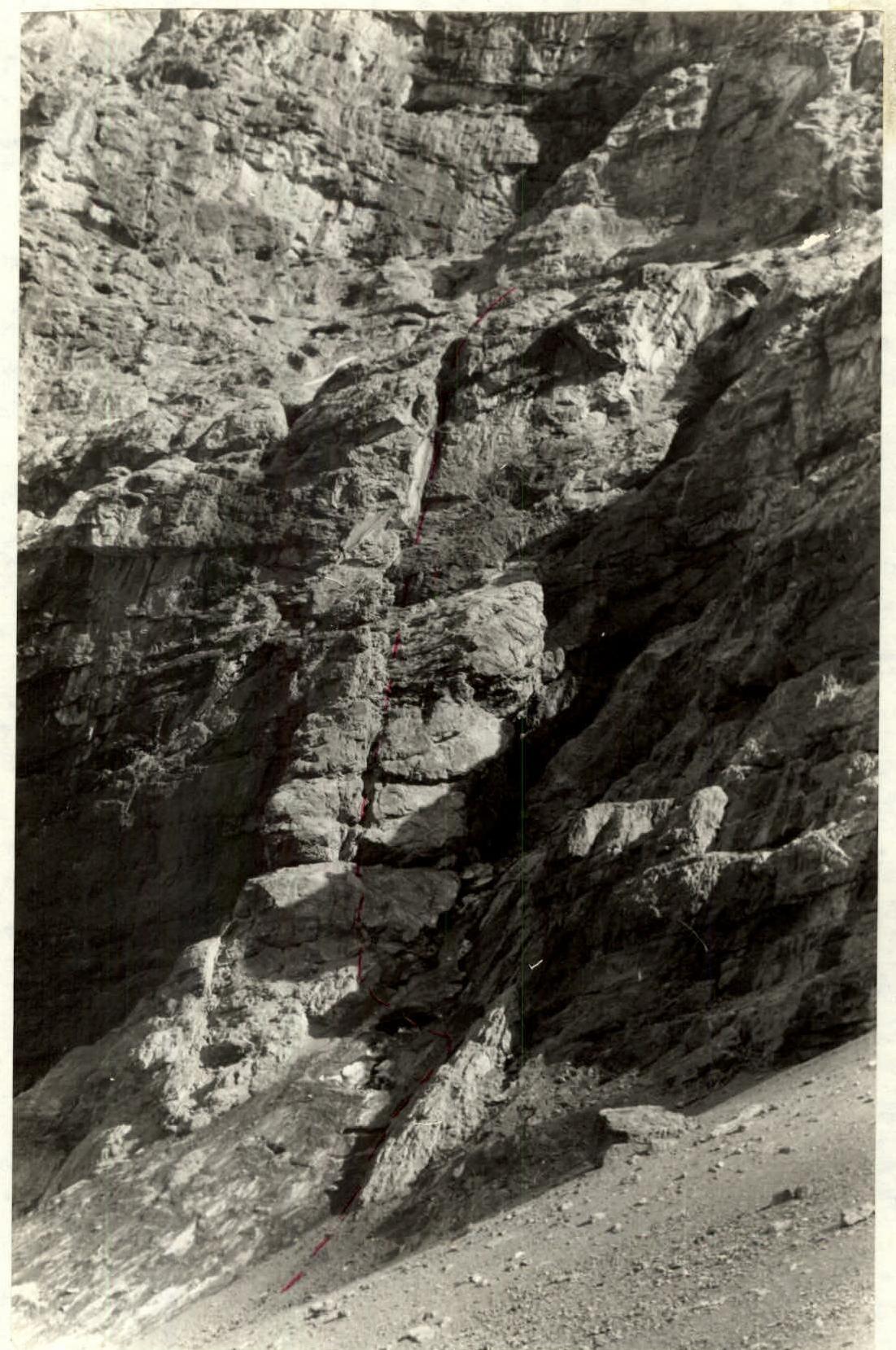 Start of the route.