Report
of the Barnaul Alpine Club (BaKA) team on the ascent of Khodzharaivat peak via the left buttress of the southern wall
first ascent, category III complexity, oriented
Participants:
Lezhnev A.P., Babushkina O.M., Mentovskaya A.A.
Ascent Details
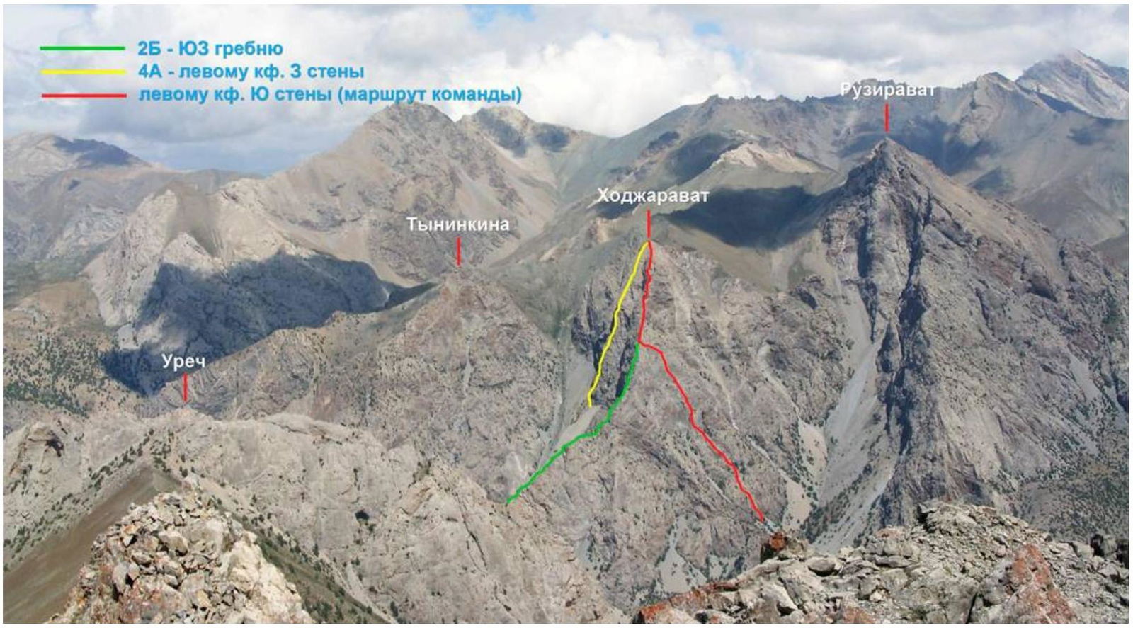
- Gissaro-Alai, Zeravshan Range, Fann Mountains — northern part, 5.3.1
- Khodzharaivat, 3600 m (requires clarification, presumably lower), via the left buttress of the southern wall.
- Proposed category III complexity, first ascent.
- Route type: rock climbing.
- Height difference: 540 m (by altimeter).
Total length of the wall section: 573 m. Length of sections (wall part of the route):
- Category III complexity — 300 m
- Category IV complexity — 53 m
Average steepness of the wall section: 60°
- Number of pitons used on the route:
rock pitons (anchors) — 25 pcs, chocks — 14 pcs, including for ITO — 0 pcs.
- Team's total climbing hours: 7 hours
- Team leader: Lezhnev Anton Petrovich, 2nd sports category
Participants:
- Babushkina Olesya Mikhailovna, 2nd sports category
- Mentovskaya Alexandra Andreevna, 2nd sports category
- Coach: Trush Vyacheslav Nikolaevich, Candidate Master of Sports
- Departure from Base Camp to Lake Bibi-Djanat: 7:00, August 4, 2013.
Start of work on the route: 8:20, August 15, 2013. Reach the ridge: 14:20, August 15, 2013. Reach the summit: 15:20, August 15, 2013. Return to Base Camp: 17:30, August 15, 2013. Descent towards the saddle between the peaks of Ruzirat and Khodzharaivat, then down the scree slope into the Kulikalon valley.
- Organization: Barnaul City Alpine Club. General view photo of the peak

Panorama of the area (from the peak Yubileynaya, August 2013)
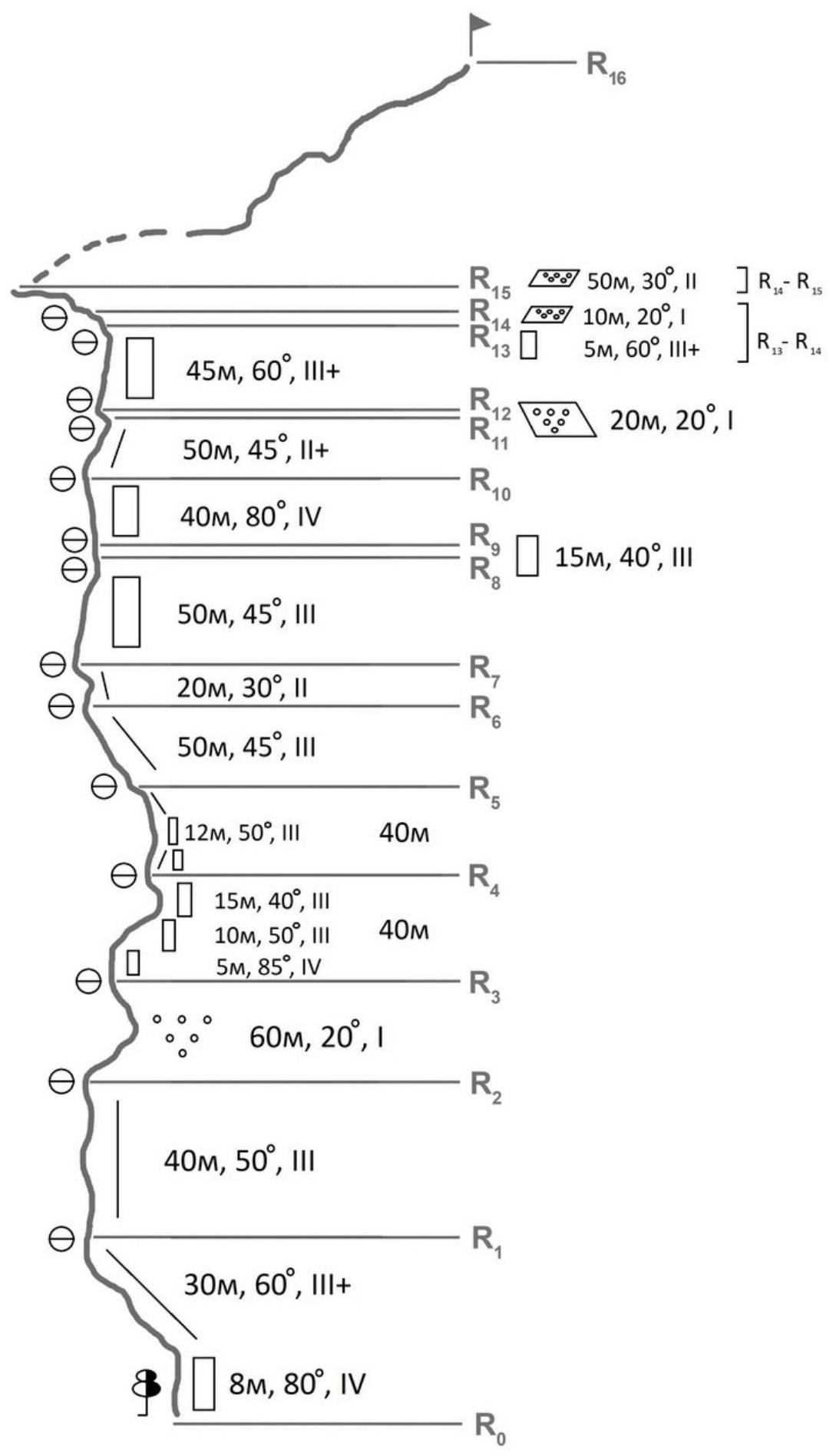
Route scheme in UIAA symbols
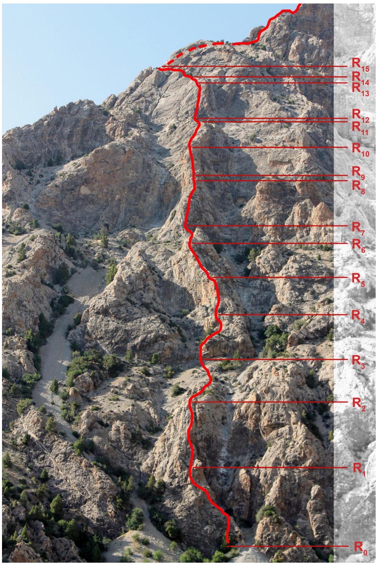
Route photo
Route photo (section R15–R16)
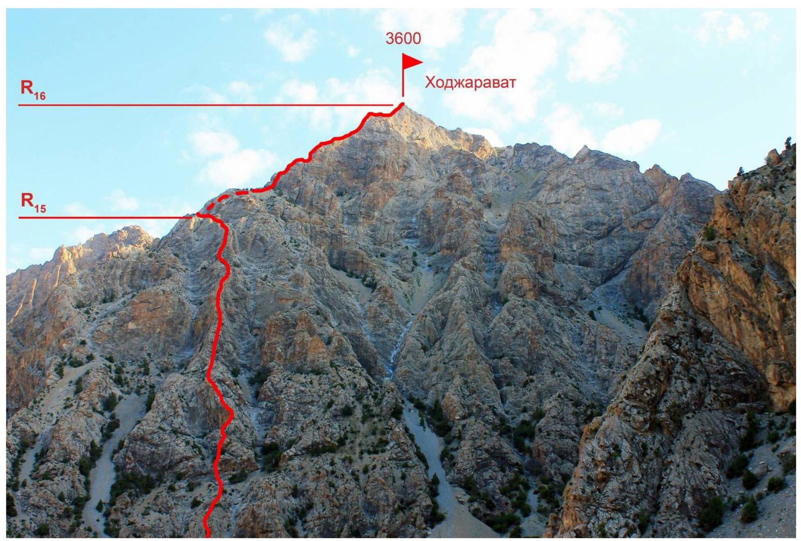
R15
Route Description by Sections
R0–R1 Start up the wall (8 m, 80°, IV) from the large arch. Then move along the
R1–R2 Rock ridge for 30 m. Station on a ledge.
R2–R3 Rock ridge for 40 m. Station on a ledge.
R3–R4 Simultaneous movement along scree with rock outcrops.
R4–R5 Start right of the couloir (visible in the photo) up the wall (5 m, 85°, IV). Then move right along the walls to a rock ridge (easy climbing). Station on an arch. Section length is 40 m. R4–R5
Bypass the wall on the left.
Then, further right, along a simple wall, exit to a rock ridge. Station on a ledge. Section length is 40 m.
R5–R6 Along a rock ridge for 50 m, alternating movement. Rocks are destroyed.
R6–R7 Bypass the rock "tooth" on the left. Exit under the wall. Section length is 20 m.
R7–R8 Up the wall (50 m, 45°, III) to a rock ridge. Station on a ledge in front of the rock "tooth".
R8–R9
- Climb the rock "tooth" directly (15 m).
- Descend from the "tooth" down the wall (2 m).
R9–R10
- Key section of the route.
- Rock wall (40 m, 80°, IV).
- Monolithic slabs alternate with destroyed rocks.
R10–R11
- Along a rock ridge, exit to a large scree ledge.
- Station on an arch.
Section length is 50 m. R11–R12. Along the ledge for 20 m simultaneously under the wall. Station on an arch. Section length is 20 m. R12–R13. Up a rock wall (45 m, 60°, III). R13–R14. Up the wall for 5 m, then along scree ledges for 10 m. Station on a ledge on a large scree ledge. R14–R15. Move left to the SW ridge simultaneously, with protection on ledges. R15–R16. The route to the summit coincides with the route along the SW ridge, category II complexity.
Alternating movement with protection on ledges. Short walls of category III complexity are frequently encountered.
Descent from the route goes towards the saddle between the peaks of Ruzirat and Khodzharaivat. Down a scree couloir under the walls of Ruzirat peak. Nearby couloirs lead to drop-offs.
Route Recommendations
The route is likely the most logical line on the southern wall, since:
- right buttresses lead to the summit tower,
- which is objectively rockfall-prone.
It is recommended to strictly follow the rock ridge of the buttress, not bypassing complex sections near couloirs, as all couloirs are prone to rockfall (visible by the color of the couloirs in the photos). Subjective hazards on the route include:
- "live" rocks,
which should not be forgotten throughout the route.
Anchors, stoppers, and medium-sized friends are suitable for the terrain. The route is quite lengthy. Careful piton protection is necessary throughout almost the entire wall section. In the team's opinion, the route corresponds to the declared complexity category.
Section photos 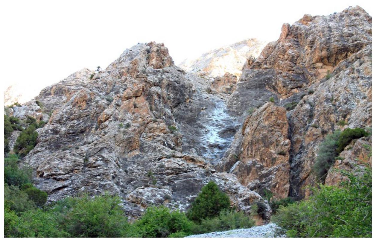
Start of the route (wall behind the arch) 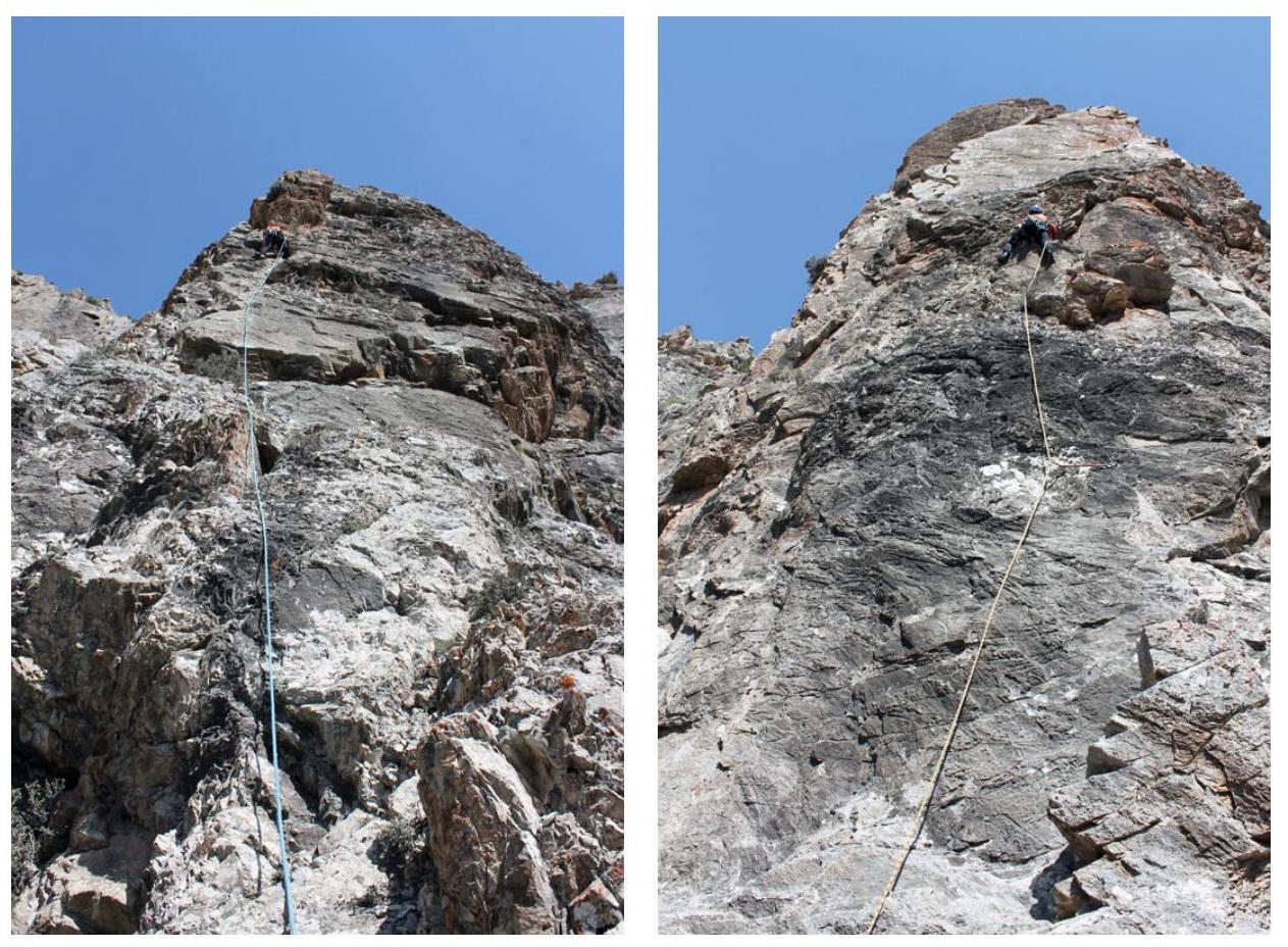
Section R7–R8 Section R9–R10 ("key")