Ascent Passport
- Climbing type — rock climbing.
- Climbing area, range — Zarafshan Range, Fann Mountains.
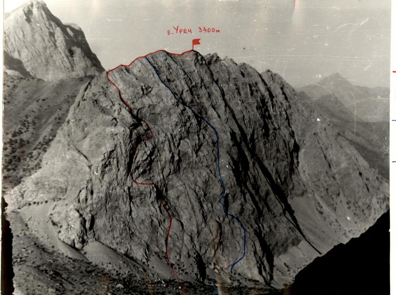
- Peak, its height, ascent route — p. Urech, 3400 m, via the left part of the NE wall.
- Proposed category of difficulty — 3B.
- Route characteristics: height difference — 450 m. average steepness — 50°. length of sections with 5th category of difficulty — 40 m.
- Number of rock pitons hammered for belay — 26.
- Number of climbing hours — 6 h 30 min.
- Full name of the team leader, participants and their qualification:
- Khmelëv S.Z. — 2nd sports category
- Atrushkevich A.M. — 1st sports category
- Kein E.O. — 1st sports category
- Murzin A.Z. — 1st sports category.
- Team coach — Mumdzhi T.M.
- Date of departure and return:
September 12, 1980.
 p. Urech 3400 m. Route via the left part of the NE wall 3B — climbed by the group. — Route via the NE wall 3B category on p. Urech (3400 m). Route via the northern counterfort 4B category on p. Urech (3400 m).
Brief description of the approach to the route
From the "Artuch" tourist center up the trail of the Urech gorge in the direction of the Kulikalon lakes. After climbing the first large moraine rise, a view of the northeastern wall of p. Urech opens up to the right. Along the trail laid on the second moraine rise, to the left part of the NE wall. Then, first along the moraine, then along the scree, we approach the start of the route. The journey from the "Artuch" tourist center to the start of the route takes 1 h 30 min.
In the left part of the NE wall, there is a not clearly defined counterfort in the form of a rock outgrowth — "fasolina". At the base of the counterfort, a guiding cairn is installed, marking the start of the route.
Route description
From the cairn at the start of the route along the left part of the "fasolina", first along a ledge, then along a rocky couloir to the scree shoulder of the "fasolina" (3 ropes). Then, up to the left along the slabs in the direction of the overhanging rocks. Through two internal corners (white smoothed rocks), exit to a small shoulder (20 m), piton belay. Further, adhering to the general direction up to the left, along the destroyed rocks (20 m). Climbing of medium complexity. A small rocky bulge is bypassed on the left. Then, vertically upwards along complex rocks (key location), in the lower part, the rocks are smoothed. Straight up the rocks and then along a series of internal corners, exit to the left onto a ledge. Control cairn. The journey from the start of the route to the control cairn takes 2–2.5 h.
From the cairn, up to the left, traverse under the yellow wall with black streaks, then to an inclined ledge under the wall (80 m). Piton belay. Then, exit to a reddish rock outcrop. From here, along a large inclined ledge under the reddish rocks upwards 40 m. General direction from left to right upwards along the ledge, turning into a crack. Piton belay. Then, 60 m along the crack next to the reddish wall, alternating belay. Then, 60 m along scree ledges, traverse up to the right under the black rocky wall, rocks are smoothed. Along the left part of the black smooth rocks, ascend 30 m, exit to a ledge leading up to the left. Along it, 250–300 m to the ridge. Movement is alternating, in places simultaneous. Further along the ridge with alternating belay to the summit.
Descent from the summit to the south to the Chuquraq pass and then down either to the "Artuch" alpine camp (to the right along the way) or to the Kulikalon lakes.
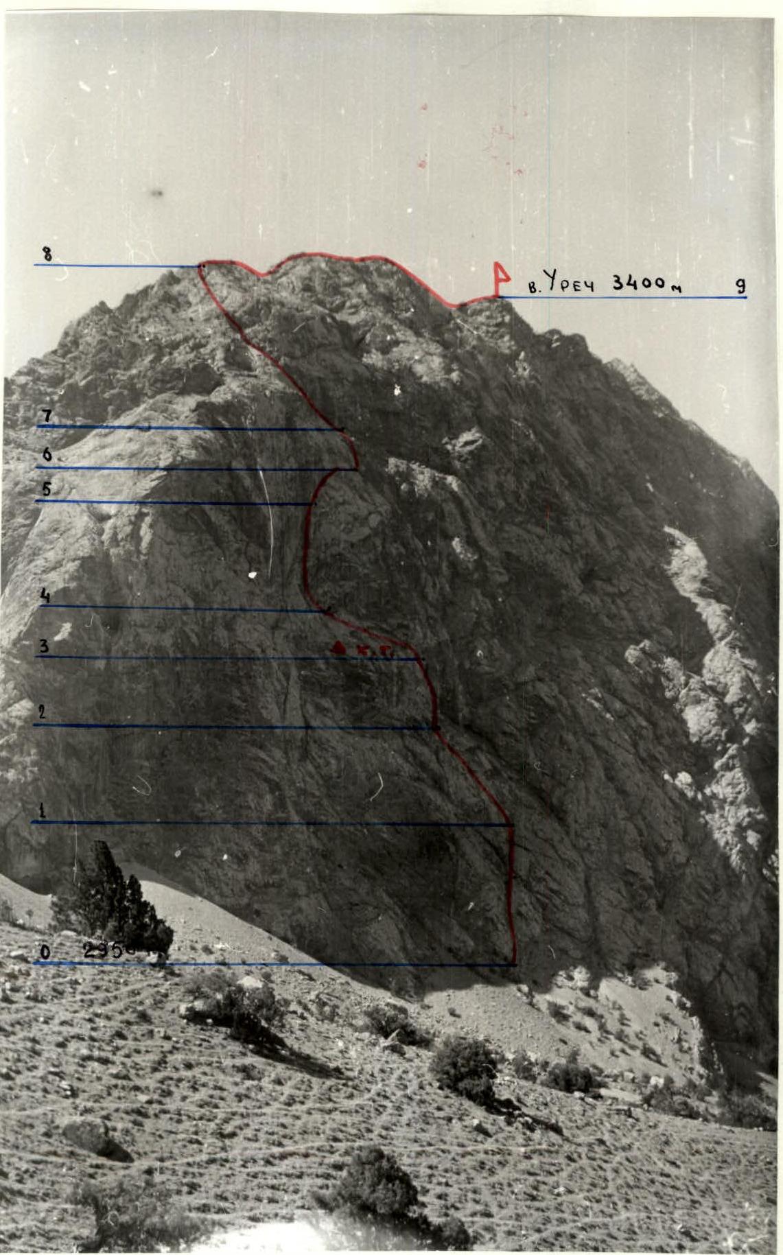
Profile of the route on p. Urech via the left part of the northeastern wall
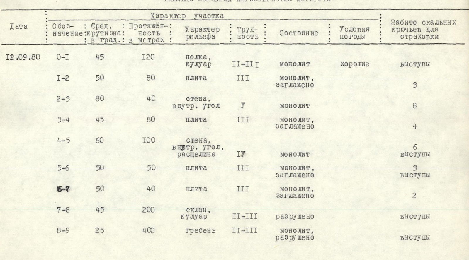
Table of main route characteristics
| Date | Designation | Average steepness in degrees | Length in meters | Terrain type | Difficulty | Condition | Weather conditions | Number of rock pitons hammered for belay |
|---|---|---|---|---|---|---|---|---|
| 12.09.80 | R0–R1 | 45 | 120 | ledge, couloir | 2–3 | monolith | good | protrusions |
| R1–R2 | 50 | 80 | slab | 3 | monolith, smoothed | 3 | ||
| R2–R3 | 80 | 40 | wall, internal corner | 5 | monolith | 8 | ||
| R3–R4 | 45 | 80 | slab | 3 | monolith, smoothed | 4 | ||
| R4–R5 | 60 | 100 | wall, internal corner, crack | 4 | monolith | 6 protrusions | ||
| R5–R6 | 50 | 50 | slab | 3 | monolith, smoothed | 3 protrusions | ||
| R6–R8 | 50 | 40 | slab | 3 | monolith, smoothed | 2 | ||
| R7–R8 | 45 | 200 | slope, couloir | 2–3 | destroyed | protrusions | ||
| R8–R9 | 25 | 400 | ridge | 2–3 | monolith, destroyed | protrusions | ||
 | ||||||||
 |