- Class of ascent — technical
- Region of ascent — Fan Mountains.
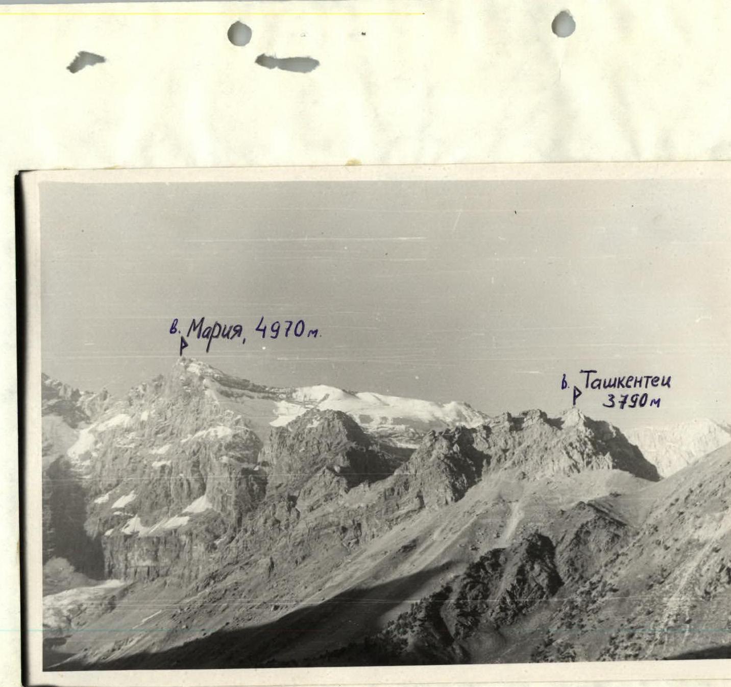
- Summit Tashkentets 3600 m via the southwest spur of the Western ridge.
- Route 3A cat. difficulty.
- Route characteristics: height difference 240 m, average steepness 45°
- Pitons driven: rock — 14, ice pitons were not used.
- Number of climbing hours — 7
- There were no overnight stays on the route.
- Team of the sports club TEIS DSO "Burevestnik": Peshkov S.V. — 1st sports category — leader Norov Yu.M. — 1st sports category Kristov V.N. — 1st sports category Uzenbaeva F. — 3rd sports category
- Team coach — Kuznetsova N.P. (Alexandrova?).
- Date of departure on the route — August 22, 1980.
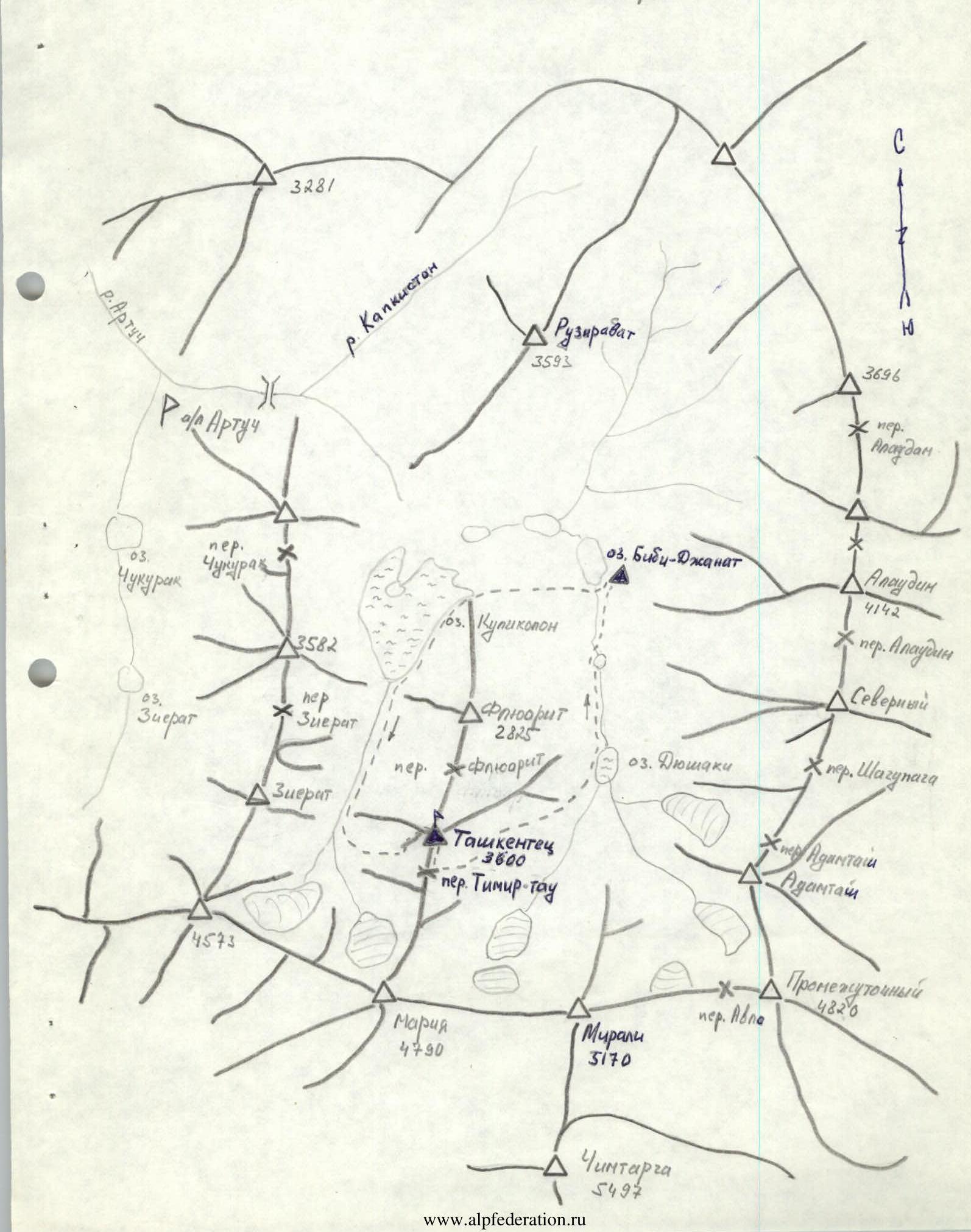
BRIEF DESCRIPTION OF THE APPROACH TO THE ROUTE
From the base camp, located on Lake Bibi-janat, cross the old moraine in the direction of Kulikolonskoye Lake. Then along the trail, which runs along the shore of Lake Kulikolon and bypasses the summit Fluorite, approach the western slope of the summit Tashkentets. Then up the scree, descending from the Tемир-Tau saddle, approach the clearly visible spur. This is the beginning of the route.
Landmarks:
- Located somewhat to the right of the route — "white" couloir (traces of falling rocks).
- At the start of the route, a cairn was built.
ROUTE DESCRIPTION
The route begins to the left of the "white" couloir. Wall with a steepness of 45°. Up the crack 40 m. We come out to the first scree shelf. I control cairn. Then along the destroyed rocks (40 m) up and out onto the second scree shelf. Ahead is a small overhanging block. We go around it on the left and come out onto the ridge of the spur.
Further:
- to the right into the chimney and up the chimney 30 m;
- we come out onto an inclined shelf — II control cairn;
- along the shelf to the crack (do not go further to the right, rockfall hazard!);
- up the crack 20 m.
We come out onto a wide shelf. The shelf 30 m leads to the Western ridge. Along the ridge (easy rocks) in 20 min we reach the summit.
From the start of the route — 6 hours.
Descent along the Eastern ridge to the saddle between Tемир-Tau and Tashkentets, and then along the trail to Lake Dashakhi (1 hour) and further along the trail to the base camp.
TABLE OF MAIN CHARACTERISTICS OF THE ASCENT ROUTE
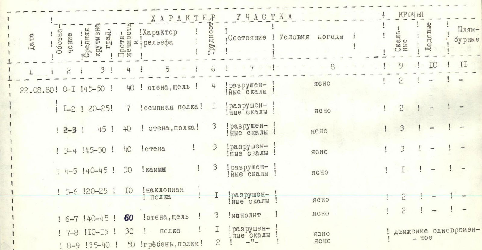
| Date | Designation | Average steepness | Length, m | Character of relief | Difficulty | Condition | Weather conditions | Rock | Ice | Bolted |
|---|---|---|---|---|---|---|---|---|---|---|
| 22.08.80 | R0–R1 | 45–50° | 40 | wall, crack | 4 | destroyed rocks | Clear | 2 | — | — |
| R1–R2 | 20–25° | 7 | scree shelf | 1 | destroyed rocks | Clear | 2 | — | — | |
| R2–R3 | 45° | 40 | wall, shelf | 3 | destroyed rocks | Clear | 3 | — | — | |
| R3–R4 | 45–50° | 40 | wall | 3 | destroyed rocks | Clear | 3 | — | — | |
| R4–R5 | 40–45° | 30 | chimney | 3 | destroyed rocks | Clear | 1 | — | — | |
| R5–R6 | 20–25° | 10 | inclined shelf | 1 | destroyed rocks | Clear | 2 | — | — | |
| R6–R7 | 40–45° | 60 | wall, crack | 3 | monolith | Clear | 2 | — | — | |
| R7–R8 | 10–15° | 30 | shelf | 1 | destroyed rocks | Clear | — | — | simultaneous movement | |
| R8–R9 | 35–40° | 50 | ridge, shelf | 2 | — | Clear | — | — | — |
Map of the area.
--- group route
Δ — base camp
 www.alpfederation.ru↗