Ascent Passport
- Ascent class - technical
- Ascent area - Pamir-Alay, Fann Mountains
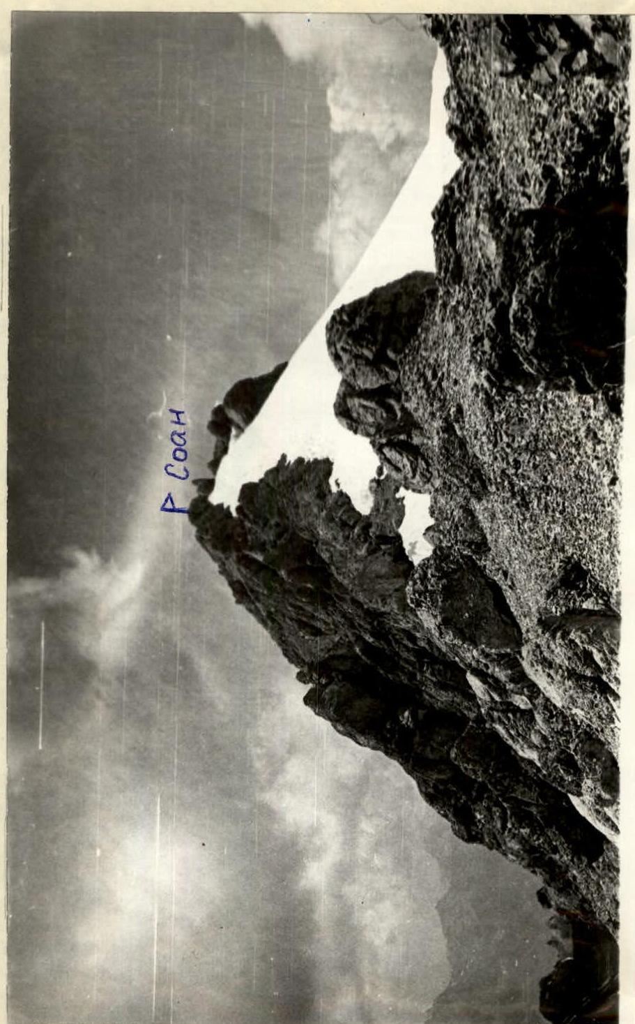
- Peak, its height - SOAN, 4750 m, northeast wall
- Estimated difficulty category - 5.5
- Route characteristics: height difference - 1300 m, section length - 5-6 km, tr. - 645 m, average steepness of main sections - 72°
- Pitons driven: for belaying; for creating ITO. Rock - 183, stoppers and eccentrics - 42, bolted - 4
- Number of climbing hours - 42
- Number of overnight stays and their characteristics: 3 overnight stays - 2 sitting and 1 good in a tent.
- Full name of the leader, participants and their qualification: leader Bелоусов Vitaliy Mikhaylovich - Candidate for Master of Sports, Lebedev Vyacheslav Georgievich - Candidate for Master of Sports, Larin Viktor Ivanovich - Candidate for Master of Sports, Ponomarchuk Viktor Semenovich - 1st sports category, Taran Nikolay Stakhovich - 1st sports category
- Team coach: Bелоусов V.M.
- Date of departure on the route and return: July 7, 1978 – July 10, 1978 Team Captain:
Scheme
SOAN Peak Area
Fann Mountains
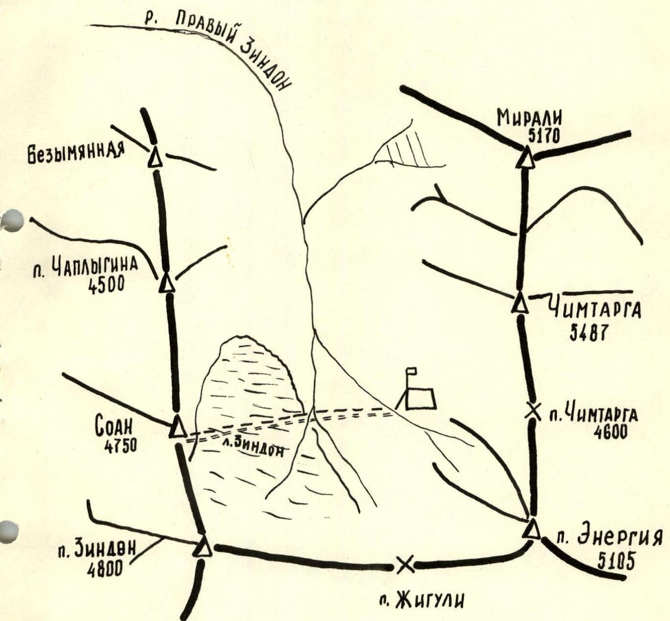
– Assault camp.
--- Approach of the assault group.
=== Descent of the assault group.

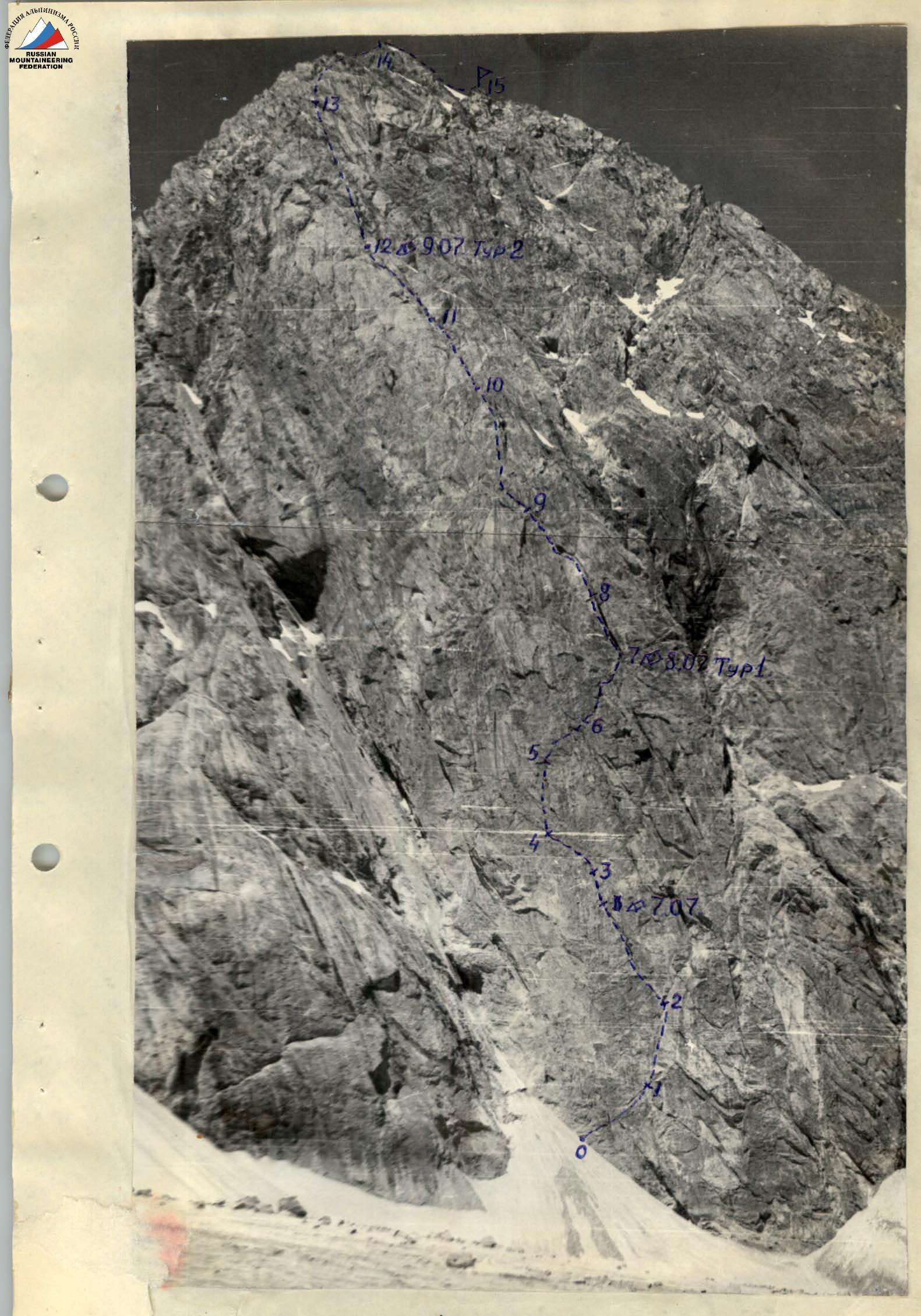
Photo 1.
Brief description of the route by sections
July 7, 1978
Section R0–R1
From the assault camp located on the right Zindon glacier, cross the glacier towards the Northeast wall of the SOAN peak. Three powerful snow cones are visible on the left side of the wall base, the right ones of which limit the buttress on the left and right. The snow cones are constantly shelled by rockfall from the vertical large gutters of the wall.
It is better to start the route from the left side of the buttress, rising along the middle snow cone slightly above its middle. Ladder usage is required from the first steps. From here, move along the monolithic wall to the right-up towards the base of a shallow inner corner. There are few cracks for pitons; holds are rare but strong. A belay is organized here on a small ledge.
Section R1–R2
Very difficult vertical climbing along the arcuate crack of the corner to the "galka" (branching of the crack to the right and left). See photo 3. There are very few holds and cracks. Ladders are used. The belay point is hanging, there are no ledges. The rocks are smoothed. The left side of the corner is vertical, the right one has 85° - smooth without cracks and holds. Above the branching of the cracks - a small cornice over the right corner, where it is absolutely impossible to drive a piton. From here, the route goes to the left into the "galka" cleft. Backpacks are pulled up with a rope.
Section R2–R3
From under the cornice above the right corner - a very difficult transition to the left cleft of the "galka". The "Zalzug" method is used. In the cleft, it is possible to organize a belay point, but there are no ledges. There are few cracks for pitons. Move along the vertical cleft to the left-up. The cleft has a slope from vertical to the left by 15°, higher it turns into a corner (see photo 4). The left face of the corner is smoothed, has no ledges, and few holds. The right face of the corner is overhanging and has small fractures. In the very corner, the rocks are heavily destroyed, and pitons do not hold. There are few places for driving pitons. Climbing is difficult, sometimes done on counter-force.
20 m from the start of the cleft - a black mark on the rocks. At this place, the cleft is vertical with a negative slope of the wall. When passing, it throws out. After the "mark" to the left up along the crack, gradually disappearing, under a bright red spot. After 30 meters, a small ledge is encountered, where two people can stand. Climbing is very difficult. The rocks are heavily cut, but have few holds. Along the crack up 5 m very complex climbing to a bright red spot. The wall above the spot is overhanging.
From the spot to the left, there is a narrow ledge, on which a sitting overnight stay is organized. There is no water.
July 8, 1978
Section R3–R4
From the bright red spot, move to the left along the destroyed ledge. The ledge has a slope of 40°. The width of the ledge is half a meter. Live rocks can be knocked down with a rope. On the ledge, a small juniper grows, from which it is necessary to pass another 10 meters to the left-up. See photo 5. There are few cracks for pitons. Stoppers and eccentrics are used well.
Section R4–R5
From the small green juniper along the inclined ledge, move to the left-up for 10 meters, and then along the vertical wall up along very complex rocks in the direction of a vertical flake. See photo 6. The rocks are heavily destroyed, ribbed, but have no holds and cracks for pitons. Here, a "pendulum" is used to enter the flake, as the wall is cut by a network of tiny cracks, and when drilling bolted pitons, it crumbles.
Along the vertical chimney, go up to the "plug" for 10 meters. Climbing is difficult. From the chimney, it throws out. In the upper part, the chimney is generally overhanging, and here it is necessary to go to the right to the wall, and along an oblique ledge-corner, as if cutting off the path along the huge flake, and again enter the chimney with a width of up to 1 meter.
Section R5–R6
Along the fracture to the right-up. Climbing is of medium difficulty. The fracture is a huge rock wall spall with a chimney exit to the left and up. In several places on the fracture, it is possible to organize a sitting overnight stay. Movement is carried out along the chimney with overcoming vertical walls by difficult climbing. Sometimes it goes to the right along the fracture itself. Gradually, with a gain in height, the chimney narrows, disappears, and the fracture turns into a series of ledges and small ledges going to the right-up.
Section R6–R7
Moving to the right-up along the ledges, it is necessary to overcome small walls by free climbing. See photo 7. Gradually, the ledges disappear, and further there is a small cleft, along which it is necessary to continue moving to the right-up.
Enter the lower part of the vertical chimney, called the "broom handle". When inspecting the route from the glacier, the chimney looks like a handle, and the fan-shaped water flows - like a broom.
July 9, 1978
Section R7–R8
The chimney is inclined to the left at an angle of 85°. The walls of the chimney are monolithic and smooth. A good place to organize a sitting safe overnight stay. Inside the chimney, there is snow and ice. A control cairn No. 1 is built right at the entrance. Up the chimney by climbing of medium difficulty. There are no cracks for pitons. Bolted pitons are used for belaying. The chimney is up to 1 meter wide and 20 meters long. At the top, you exit from under the base of a huge inner corner, which is a continuation of the chimney.
Section R8–R9
The inner corner is also inclined to the left at an angle of 70-80°. The left side of the corner is inclined at an angle of 70°, and the right one is sheer. The left side is smoothed, monolithic, has few cracks for pitons and holds. The right side of the corner is speckled with tiny cracks; when driving pitons, it crumbles. In the very corner, the rocks are completely destroyed. It is possible to knock down stones touched by a rope. Wet snow is falling. Water flows along the left wall and corner. Climbing is difficult. The inner corner ends, and the route goes out onto the wall.
Section R9–R10
Up the wall along the cracks, which are a continuation of the inner corner. See photo 8. Climbing is difficult. Further, the route again enters a huge inner corner with loose rocks in the very corner. The walls of the corner have few cracks and holds. When passing the corner with backpacks, it throws out of it. Wet snow is falling, water flows along the walls of the inner corner. It is necessary to pass this section carefully, as there are many small live rocks in the corner and their knocking down by a rope is possible.
Section R10–R11
The inner corner leads to a wide rib of the buttress itself. Monolithic strongly ribbed rocks go in 5-7:7 m in alternation with osypny ledges. See photo 9. It is necessary to adhere directly to the very ridge of the buttress. The walls are overcome by difficult and medium climbing. There are very few places for driving pitons. All rocks are speckled with a tiny network of surface cracks.
Section R11–R12
The general direction of movement is up along the left part of the buttress. One of the walls is overcome along an oblique ledge going to the left-up. It is very difficult to crawl through. The route goes out onto an osypnaya ledge, from which it is necessary to overcome a rock peak 10 m high along a small chimney. Further, the route again goes out onto the buttress. The right side of the buttress is icy. It goes along the left edge of the rib, along the border of the wall on the left and ice on the right. See photo 10. It is necessary to clean the holds from ice. In the upper part, the right snow slope becomes more gentle and forms a crest 15 meters long. A place for a good overnight stay with setting up a tent. A cairn 2 is built.
Section R12–R13
From the overnight stay site, go to the wall to the left-up along a destroyed crack to osypny ledges, from which again exit to the right onto the buttress. Climbing is initially medium, and then easy along the ledges. The general direction is towards the peak in the uppermost part of the buttress. The rocks are finely destroyed, crumble. The holds are not monolithic, under load they are torn off. Rare cracks for pitons. From the right, the rocks are icy. A 50° slope on the right and vertical walls on the left form a cant. It goes mainly along the cant.
Section R13–R14
The buttress turned into a ridge with heavily destroyed towers-walls, osypny ledges. The rocks are tile-like with a characteristic slope of holds towards oneself. There are very few cracks for pitons. Belaying on the ridge is mainly simultaneous. There are many rock blocks and walls 8-10 m high, which are overcome by climbing. The route goes out onto the pre-summit ridge along heavily destroyed rocks.
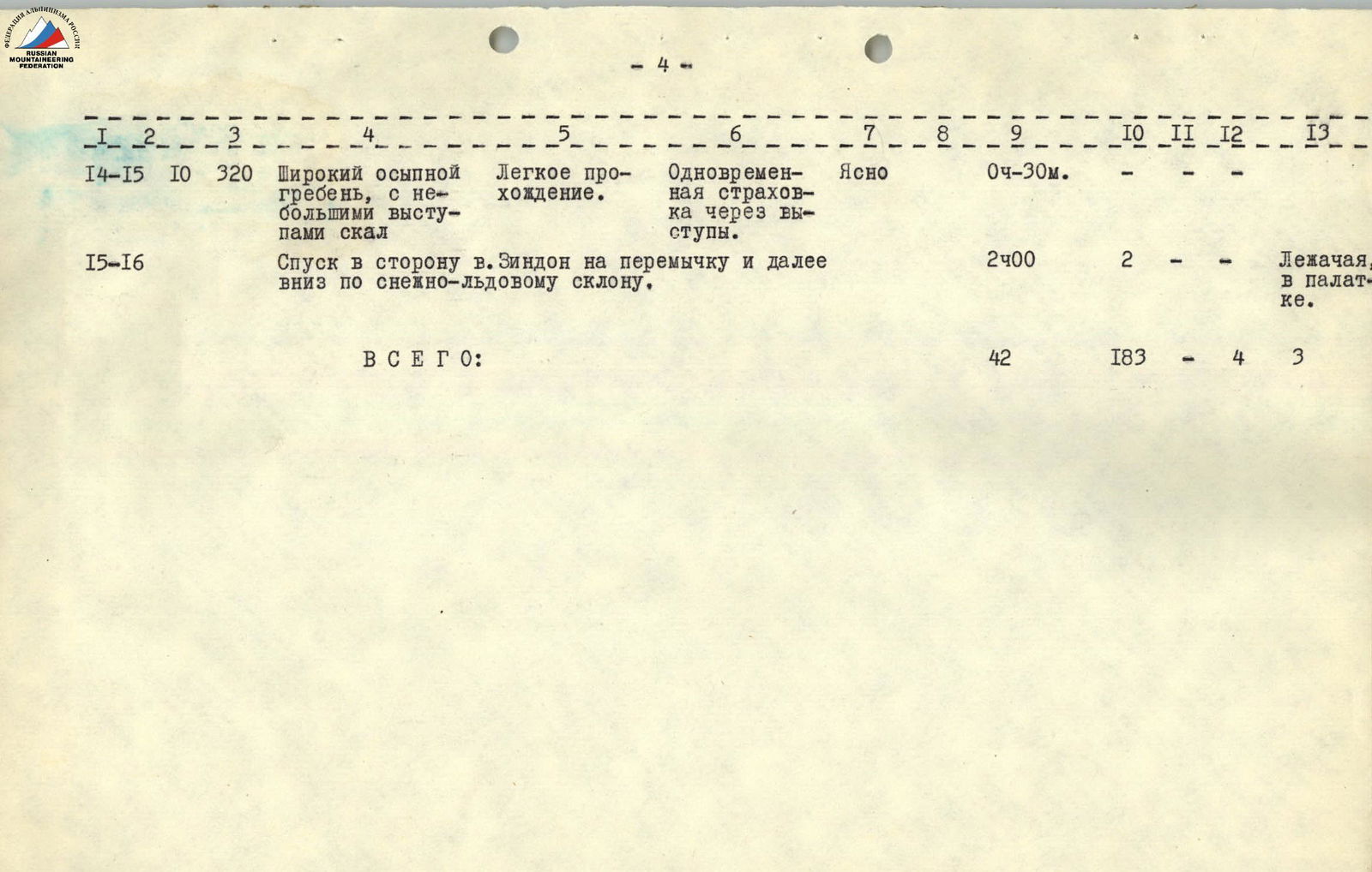
Section R14–R15
Along the pre-summit ridge to the summit 300-350 meters. At first, an osypnoy ridge, and then there are heavily destroyed rocks to the summit. See photo 11. On the right - a snow-ice slope.
Section R15–R16
The descent is carried out on a saddle towards the Zindon peak along heavily destroyed rocks and osypi. In the lower part (to the saddle), a sports descent is organized along a rope. From the saddle, it is necessary to descend along the left edge of the rocks along the slope along an inclined snow belt lying between the SOAN and Zindon peaks, to the Zindon glacier.
The descent from the summit to the glacier took 4 hours 00 minutes.
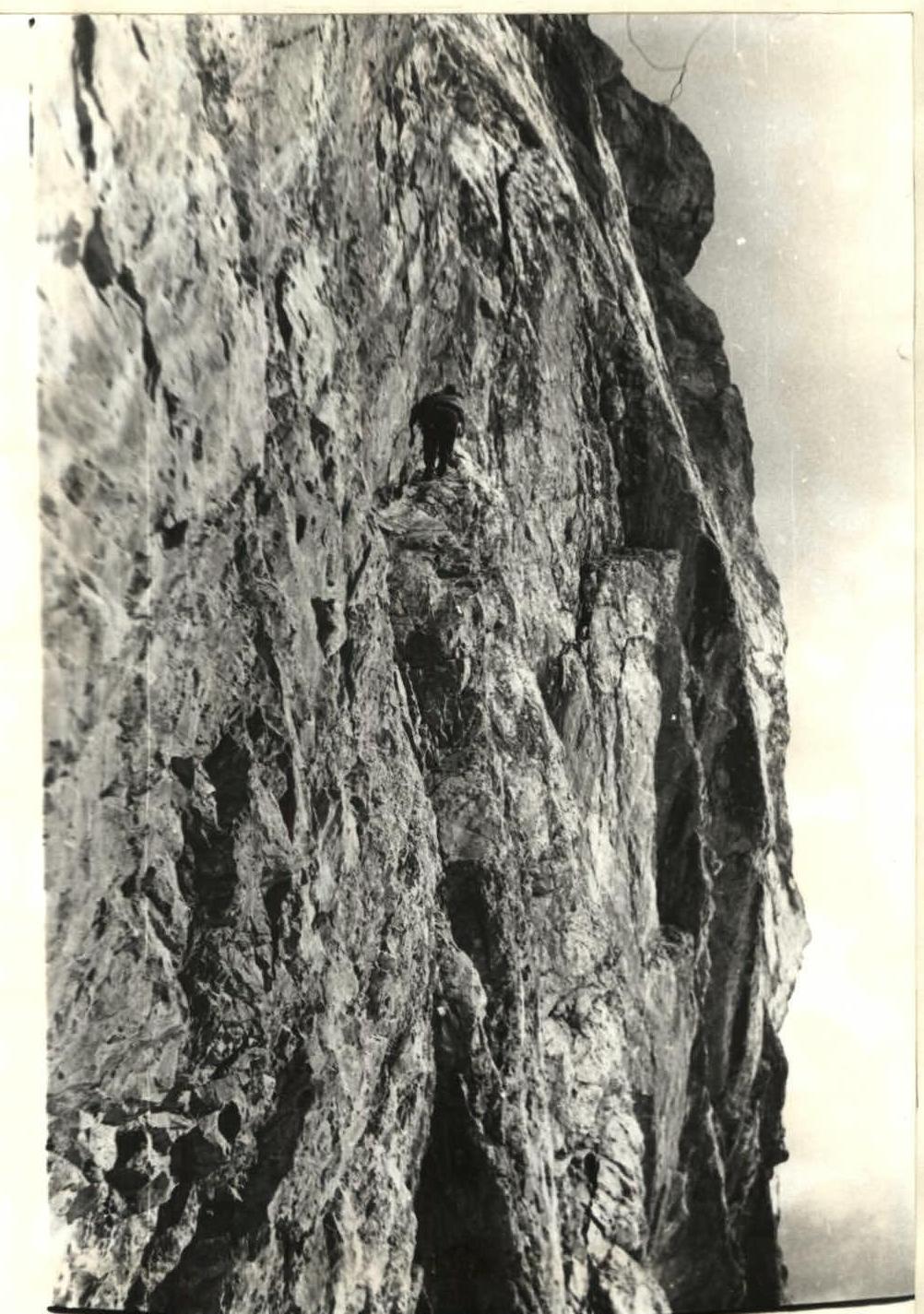
Photo 7. Section R6–R7
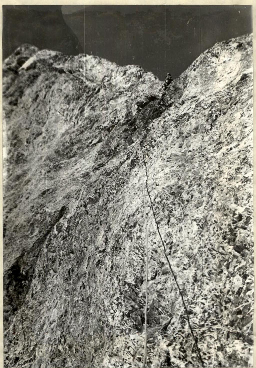
Photo 9. Section R10–R11
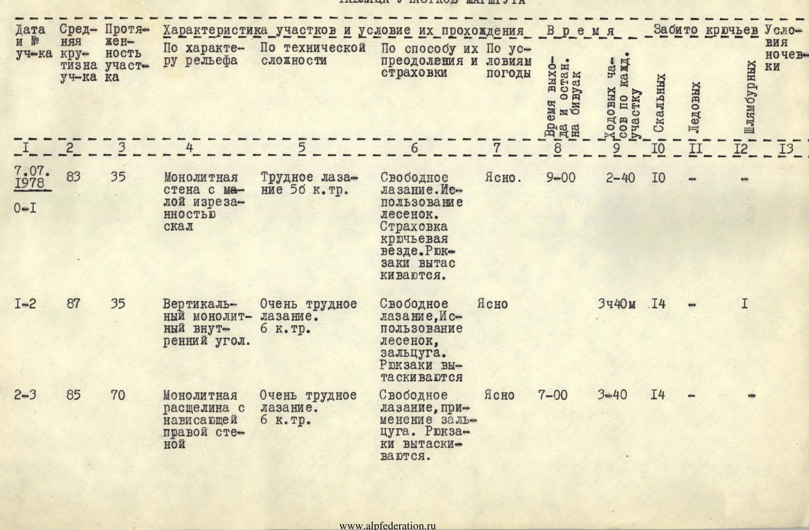
Route sections table
| Date and Section No. | Avg. steepness of section | Section length | Characteristics of sections and conditions of their passage | Time | Pitons driven | Overnight stay conditions |
|---|---|---|---|---|---|---|
| By relief character | By technical complexity | By method of overcoming and belaying | By weather conditions | |||
| 7.07.1978 R0–R1 | 83 | 35 | Monolithic wall with low rock cut | Difficult climbing 5-6 cat. | Free climbing. Ladder usage. Piton belaying everywhere. Backpacks are pulled up. | Clear |
| R1–R2 | 87 | 35 | Vertical monolithic inner corner. | Very difficult climbing. 6 cat. | Free climbing, ladder usage, zalzug. Backpacks are pulled up. | Clear |
| R2–R3 | 85 | 70 | Monolithic cleft with overhanging right wall | Very difficult climbing. 6 cat. | Free climbing, zalzug application. Backpacks are pulled up. | Clear |
| 8.07.1978 R3–R4 | 80 | 20 | Narrow inclined ledge with vertical walls below and above the ledge | Climbing of medium difficulty 5A cat. | Free climbing. Piton belaying everywhere. | Clear |
| R4–R5 | 85 | 35 | Monolithic wall without holds, very few cracks. Vertical chimney with a plug | Very difficult climbing. 6 cat. | Free climbing, "pendulum" application to exit to the flake | Clear |
| R5–R6 | 80 | 35 | Vertical flake with smooth walls. | Medium climbing. 5A cat. | Free climbing. | – |
| R6–R7 | 65 | 35 | Flake having vertical walls. | Climbing of medium difficulty 5A cat. | Free climbing. | – |
| 9.07.1978 R7–R8 | 87 | 30 | Vertical chimney with smooth walls, without cracks and good holds. | Difficult climbing. 5-6 cat. | Free climbing on counter-force. Piton belaying | Fog, damp |
| R8–R9 | 80 | 50 | Vertical inner corner with smooth walls. The right side is vertical, the left is slightly inclined. | Very difficult climbing. 6 cat. | Free climbing, ladder usage. | Wet snow |
| R9–R10 | 70° | 70 | Huge inner corner with loose rocks in the very corner. The walls have few cracks and holds. | Difficult climbing. 5A cat. and some medium climbing. | Free climbing, with backpacks throws out of the corner. | Wet, fog, snow |
| R10–R11 | 60° | 35 | Monolithic rocks of the buttress alternating with osypny ledges. | Medium and difficult climbing. 5A cat. | Free climbing with overcoming vertical walls. | Damp fog |
| R11–R12 | 55 | 70 | Steep icy rocks, snow-ice slope. | Medium climbing. 5A cat. | Free climbing, cleaning holds from ice. | Fog |
| 10.07.1978 R12–R13 | 60° | 320 | Buttress in the form of smoothed "lba", rocks are tile-like, few cracks. | Climbing of medium difficulty. 4 cat., 5A cat. | Free climbing. Piton belaying. | Clear |
| R13–R14 | 45° | 360 | Heavily destroyed ridge with towers-walls, osypny ledges. | Easy climbing. | Free climbing. | Clear |
| R14–R15 | 10 | 320 | Wide osypnoy ridge, with small rock outcrops. | Easy passage. | Simultaneous belaying through outcrops. | Clear |
| R15–R16 | Descent towards the Zindon peak to the saddle and further down along the snow-ice slope. | |||||
| TOTAL: |

Brief overview of the area
The 4010 m and 4100 m peaks are located in the Surkob river valley, one of the tributaries of the Pasrud-Darya river. The peaks are part of the northern spur of the Big Ganzan peak and are located in the center of the cirque formed by the peaks: Bars, 4700, Big Ganzan, Sobor.
Before the ascent, both peaks did not have an official name. Local residents call the 4010 m peak - Surkh ("Red"), and the 4100 m peak - Surkob ("Red water").
Geologically, the peaks are located in the northern part of the Fann Mountains. The structure consists of marbleized limestone. Monolithic rocks. Few cracks. On the rocks, there are characteristic red spots - caves and niches covered with cornices.
Route: from Dushanbe through the Anzob pass (along the Dushanbe-Leninabad highway) drive to the city of Zervshan-2. Further - turn left into the Pasrud-Dara gorge. Drive to the village of Pasrud (6 km) and to the upper village of Marguzor. From this village, 4 km to the bridge across the Pasrud-Darya river and the confluence of the Surkob river. The confluence of the rivers is very beautiful and has a local name - Sangi-Safed. From here, the upper part of the 4010 m peak is clearly visible up the Surkob river. From the confluence of the rivers, turn left along the road for 1 km to the shepherd's summer camps. Here the road ends. Go along the trail located on the right side of the river for 2-2.5 hours. Along the way, another summer camp is encountered. The trail leads to a picturesque cirque with birch and juniper groves. There are convenient places for helicopter landing. In this area, planned tourist routes pass.
In general, the area is promising in sports terms. Convenient places for organizing a base camp. Plenty of firewood. The area has:
- peaks on which ascents have not been made;
- peaks on which it is possible to make first ascents of 1-5 cat. difficulty.
Short approaches to the routes. The approach from the base camp to the N wall of the 4010 m peak takes 40 minutes.