Ascent Passport
- Ascent class - technically challenging
- Ascent area - Fann Mountains, Levyy Zindon gorge
- Ascent route, peak, its height - Mt. SOAN, 4750 m, north face of the north-west ridge
- Proposed difficulty category - 5B
- Route characteristics:
height difference - 1400 m, route length - 2400 m, length of sections 5-6 cat. diff. - 390 m, average steepness:
- walls - 65-70°
- ridge - 30°
- Pitons driven:
for belay:
- rock - 101
- bolt - 1
- chocks - 25
- Number of climbing hours - 25
- Number of nights and their characteristics: one overnight stay on a scree ledge, comfortable, lying down, with snow
- Team name - LGS DSO "Spartak"
- Surname, I.O. of the captain, participants and their qualification: Kruglov Evgeny Mikhailovich - CMS, Ekimov Sergey Mikhailovich - MS, Isachenko Gennady Ivanovich - CMS, Razumov Yuri Mikhailovich - MS, Silin Boris Mikhailovich - CMS
- Team coach: Kolchin Alexander Alexandrovich - IMS
- Ascent time: August 17, 1980 - August 19, 1980
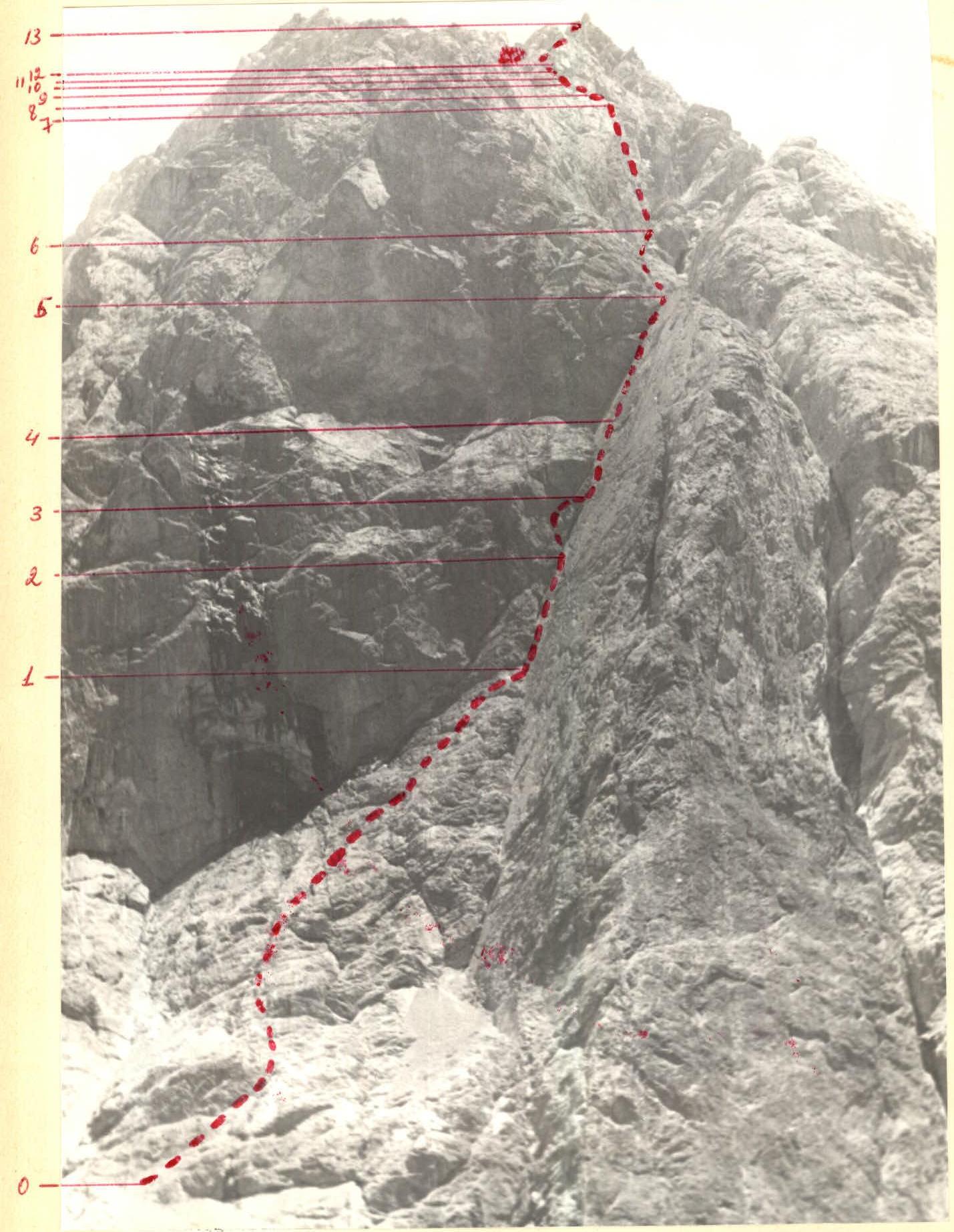

Ascent route profile to Mt. SOAN via the north face of the north-west ridge
Geographical and mountaineering description of Mt. SOAN
Mt. SOAN is located in the ridge separating the Pravyy and Levyy Zindon gorges. The same ridge includes the peaks (starting from Lake B.Allo):
- Peak 4200 m,
- Nameless,
- Chaplygin Peak,
- SOAN,
- Zindon.
Two routes have been laid on Mt. SOAN from the Pravyy Zindon gorge side: 5A cat. diff. via the right part of the wall and 5B cat. diff. via the left part of the wall. The left and right parts of the wall are separated by a couloir where giant rockfalls often occur. During such rockfalls, some rocks fall onto the sections of the 5B cat. diff. route, making the passage of the route unsafe.
From Mt. SOAN, a series of long ridges of north-western orientation descend towards the Levyy Zindon gorge, ending in steep walls above Lake Zindon. The couloirs separating these ridges in the upper part cut through the walls in narrow canyons with waterfalls. No routes had been passed on Mt. SOAN from this side, likely due to the impassable walls.
The north-west walls of Mt. SOAN were first noticed by the team coach Kolchin A.A. The most logical route appeared to be the one leading to the central ridge, which drops towards Lake Zindon with sheer rock cliffs, bounded on the right by an inclined wall of northern orientation, forming a giant internal angle 400 m long. Team members studied this route in detail during their ascent to Mt. Amshut and a reconnaissance exit from the slopes of Mt. Demo.
Description of the approach to the north-west ridge of Mt. SOAN. From the base camp at Lake B.Allo, up the Levyy Zindon gorge to Lake Zindon. From it, to the left (in the direction of travel) towards the internal angle formed by the sheer wall and the 60° inclined wall, an scree slope leads. The inclined wall is visible from Lake B.Allo and is the main landmark of the route. There are comfortable overnight stays at Lake Zindon. The approach from the base camp takes 2 hours.
Tactical plan of the ascent and its implementation. The ascent to Mt. SOAN was planned for the end of the gathering, when the team members would be in top form. Prior to that, several ascents of 5B cat. diff. and one of 6 cat. diff. had been made.
The ascent was planned with one overnight stay on the wall part of the route. Special attention was paid to the selection of equipment and supplies. The weight of the backpacks was minimized so that the first climber could ascend without a backpack, while the others would climb with backpacks. Rope hauling was not planned.
Route passage by days: August 17, 1980. We left the base camp at Lake B. Allo at 13:00 and set up a bivouac under the route on the moraine by Lake Zindon at 15:00; the Silin-Isachenko pair began processing the route up to the internal angle. The initial section (250 m) is a gentle slope resembling "sheep's foreheads" with ledges of average steepness 45°. The other participants continued to observe the route and further study it with binoculars. August 18, 1980. We set out at 6:00 and reached the internal angle by 7:00 via the fixed ropes. The first rope (Isachenko-Kruglov) begins working in the angle. The left side of the angle is sheer, with some overhanging sections. Pitons (mainly cams) are driven into the left wall and into the crack in the angle. Chocks are often used. After 120 m, we exit onto the left wall onto a vaguely defined inclined ledge, bypassing a difficult overhanging section. Then we return to the angle. The upper part of the angle is difficult to traverse due to a lack of cracks, so we move to the right wall with small holds. There are few cracks, but some exist. At one point, a bolt piton is driven for belay. By 15:00, we pass the right wall and enter a couloir-canyon separating the ridges. Along a ledge, we reach a vaguely defined internal angle leading left-upwards to the main ridge.
At the base of the internal angle, there is a comfortable scree ledge for an overnight stay. Further up the internal angle to a smooth wall of reddish color under the eaves, and along it a traverse to the left (very difficult 20 m) with an exit to a ledge. After the ledge, a relatively easy exit to the ridge. Just beyond the ridge, there are comfortable overnight stays, which we reached by 21:00. August 19, 1980. We set out at 9:00.
The ridge is not difficult, but long:
- The first half (up to the scree field) is steeper and more challenging
- The second half - simultaneous movement
We reached the summit by 16:00. The descent to the saddle between Mt. Zindon and Mt. SOAN and further down the scree into the Levyy Zindon gorge presented no difficulties and took us 2 hours.
Brief explanation of the table
The NW ridge of Mt. SOAN descends to Lake Zindon. The beginning of the route is an internal angle formed on the left by a wall (the western wall of the ridge) with an average steepness of 80°, and on the right by a smooth 400-meter north-facing slab with a steepness of 60°. This smooth slab is visible from the start of the Levyy Zindon gorge from Lake B.Allo and serves as the main landmark for the start of the route.
The entry into the internal angle is made from the left along ledges and walls below the "sheep's foreheads" (R0-R1). The route then follows the internal angle.
On the first rope of the internal angle, on the left wall, the first control cairn hangs on a piton. The left wall of the internal angle is in some places overhanging, heavily broken, with many loose rocks, so belay points should be chosen under the overhanging sections. This applies to the entire internal angle.
The overhanging section in the middle part of the internal angle is bypassed along the left wall (R2-R3). The upper section of the internal angle (where it overhangs) is more conveniently passed along the slab with small, overhanging holds, but monolithic. There are few places to drive pitons. At the end of the first rope on R4-R5, a bolt piton is driven for belay.
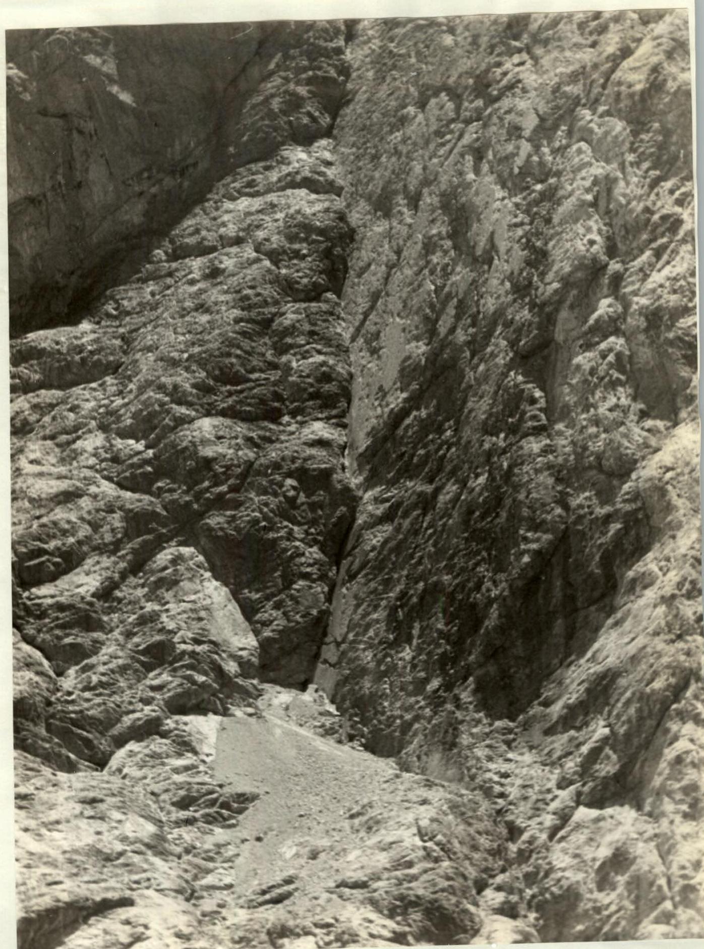
After the internal angle, we enter a giant couloir formed by two ridges. Along a ledge on the left part of the couloir (R5-R6), crossing the scree, we ascend along a ledge under a vaguely defined internal angle on the left (in the direction of travel) wall of the couloir. 10 m from the scree. The initial section of the internal angle overhangs.
The route then:
- goes left upwards towards the right end of the ledge, which leads left onto the ridge (R6-R7);
- the ledge goes under the eaves and turns into a steep, smooth slab (R7-R8);
- From the left end of the ledge (R8-R9), an exit up the internal angle (R9-R10) onto a ledge, from which a small wall leads to the ridge.
On the ridge, the second control cairn is set. Beyond the ridge, there is a comfortable spot for an overnight stay.
To the left of our ridge, another ridge runs. They are separated by a giant couloir with flowing water and falling rocks. In the upper part, the couloir contains ice and snow.
The route continues along the ridge and left scree ledges (R12-R13). The ridge leads to a large scree. Along the scree, we exit to the base of several ridges.
It is then convenient to ascend along the center. Start of R13-R14. After 100 m, we enter a rocky depression with many rocks and then onto a ridge leading to the summit. The ridge is easy, with simultaneous movement.