Passport
- Technical class
- Pamir-Alay, Shan mountains, Zeravshan ridge
- Peak Zamok via the right part of the North wall of Parandas shoulder
- Proposed 5B cat. diff., first ascent
- Elevation gain 1100 m, length 1892 m.
Length of sections with 5–6 cat. diff. is 876 m. Average steepness of the main part of the route is 76° (3800–4380), including:
- 6 cat. diff. 86° (3960–4060)
- 85° (4080–4165)
- 120° (4200–4205)
- 95° (4240–4255)
- 95° (4295–4310).
- Number of protection points used:
| Rock pitons | Bolt pitons | Ice screws | Chocks and cams |
|---|---|---|---|
| 59 | 8 | 35 | 248 |
| 35 | 8 | 0 | 40 |
- Team's travel time is 31 hours and 3 days.
- Overnights: 1st - sitting on a rocky-snow ledge for 6 people. 2nd - comfortable bivouac on the saddle between v. Zamok and Parandas shoulder.
- Alpine and rock climbing qualifications:
| Alpine qualification | Rock climbing qualification | |
|---|---|---|
| Team leader Arkhipov V.A. | CMS | CMS |
| Team members Balezin V.V. | MS | MCMS |
| Lebedev V.A. | MS | MS |
| Kokhanov V.P. | CMS | MS |
| Kuzin A.V. | CMS | CMS |
| Kuznetsov A.V. | CMS | CMS |
- Coach: Sapozhnikov Yury Georgievich.
- Departure to the route: August 11, 1987. Summit: August 13, 1987. Return: August 13, 1987.
- Organization: Goskomsport RSFSR.
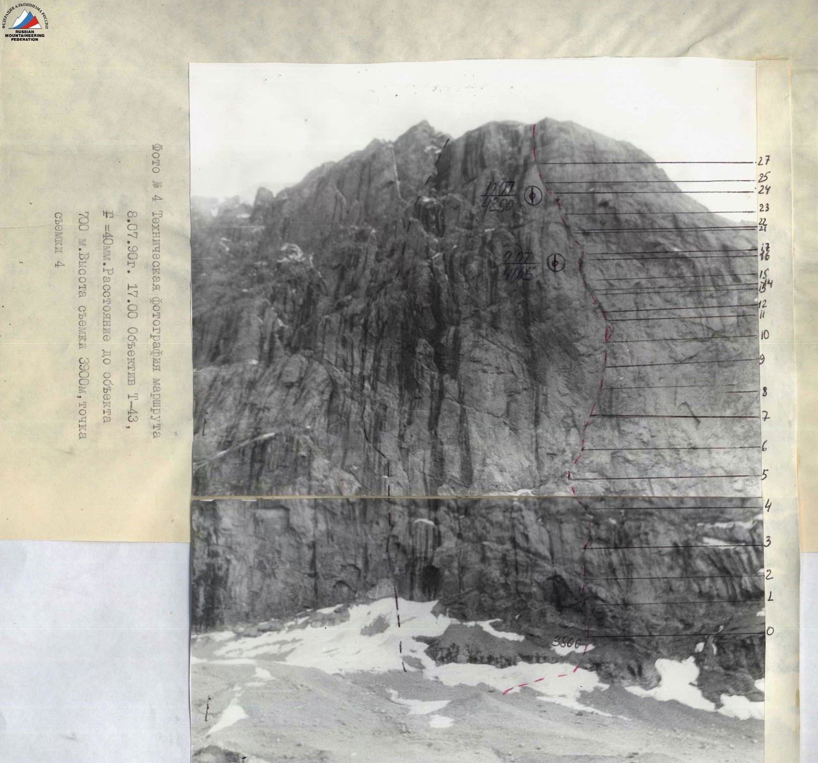 Photo # 4. Technical photo of the route. August 8, 1990, 17:00. Lens T-43, F=40 mm. Distance to the object 700 m. Shooting height 3900 m, shooting point 4.
4380
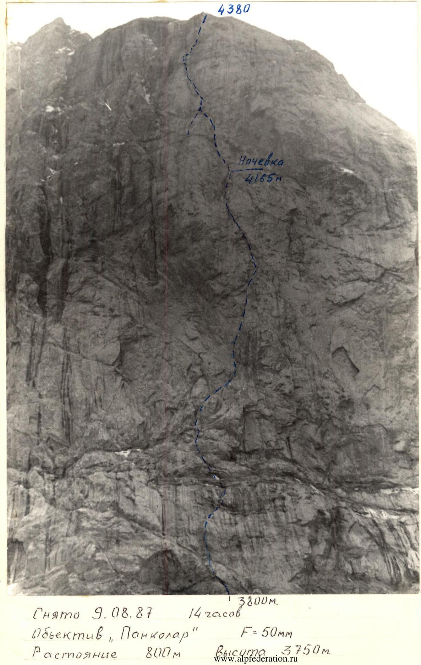 General photo of the summit. Taken on August 9, 1987, 14:00. Lens "Pancolar", F=50 mm. Distance 800 m, height 3750 m.
 Photo of the wall profile from the right. Taken on August 9, 1987, 16:00. Lens "Pancolar", F=50 mm. Distance 3200 m.
 Photo of the profile from the left. Lens "Pancolar", F=50 mm. Taken on August 9, 1987, 15:00. Distance about 3950 m.
- The team's tactical actions were carried out in accordance with the tactical plan.
- On August 11, the team covered the section R0–R15 as planned.
- On August 12, having passed the section R15–R25, the team reached the ridge of Parandas peak at 16:20, with a 1 hour 20 minutes delay from the tactical plan. The delay occurred due to the third cornice of the section R21–R22 being more difficult than expected, and it took 3 hours to pass instead of the planned one and a half hours.
- The team reached the saddle between v. Parandas and v. Zamok at 16:00. Further movement was considered dangerous due to ice on the path to the bastion of v. Zamok. It was decided to organize an overnight stay on the saddle between v. Parandas and v. Zamok to ensure safety, rather than on the rocky bastion of v. Zamok as planned, and to pass the dangerous section before sunrise.
- On August 13, at 5:00, the team started moving, reached the rocks of the bastion of v. Zamok at 7:00, and reached the summit of Zamok at 12:00.
- The team returned to the base camp at Alaudin lakes on August 13 at 17:00 as planned.
- The organization of rope teams, their interaction, and leader changes were carried out in full accordance with the tactical plan.
- To ensure the safety of the first climber on difficult sections, the following were used:
- moving on a shortened rope,
- on a double rope,
- with the use of chocks, rock, ice, and bolt pitons.
- Belaying of the first climber at the belay station was done through a Sticht plate.
- The last person in the group moved along the fixed ropes with top-rope belay.
- The team's movement during the day was continuous.
- Participants were fed using individual packs with high-quality products.
- The first overnight stay was organized on a small ledge in a tent under a cornice, ensuring its safety.
- The second overnight stay was also in a tent on the saddle between v. Zamok and v. Parandas.
- When passing difficult sections of the route, it was necessary to clarify the planned options along the way, and a time reserve was planned for these sections.
- The route was completed with a sufficient margin of safety.
- The organization of overnight stays began with at least 2 hours of daylight remaining, allowing for quality rest and preparation for the next day's movement.
- All sections of the route were passed reliably with the necessary safety measures for all team members.
- A rescue team of five people, including a doctor, was located on the moraine directly below the route.
- The observers' radio station was constantly on receive.
- Radio communication with the team was conducted according to schedule.

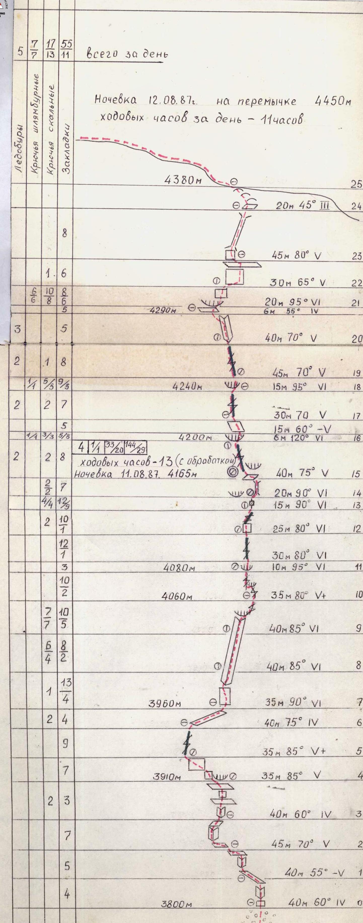
Route description by sections
The route starts under a clearly defined sheer inner corner, beginning 100 m above the start of the route, to the left of the main crack in the shape of a "dollar". Movement is left-upwards through a black talus shelf to a cleft left of the sheer inner corner, section R5–R6. The route then goes 30 m up the cleft, section R5–R6. Then right-upwards along an inclined shelf, section R6–R7, to a long, about 80 m, inner corner that ends in a cornice. The approach to the corner is along a 30 m wall, 6 cat. diff., section R7–R8. Further movement is along the inner corner with a cornice, section R8–R10, the upper part of which and the cornice are passed using artificial aids, mainly on rock pitons. Section R10–R11 follows the main "dollar" crack for 3 m to the next cornice, section R11. The exit to the cornice is done by free climbing from the left, 6 cat. diff., and then over the cornice to the right to a crack where it is possible to organize reliable belay through chocks. Further movement is along a steep crack, section R11–R15, and exit to a finger of rock, over which a cornice overhangs. I-st control point. Overnight stay with tent setup is only possible at this location. Further, it is possible to organize a comfortable overnight stay only by rope to the exit to the ridge.
Sections:
- R15–R16: 40 m along the crack, approach to the cornice. The crack is partially filled with ice; the use of ice screws as belay points is possible.
- R16–R17: the cornice is passed on the right part using artificial aids.
- R17–R18: After 40 m of movement along the crack, the approach to the next key location, a hanging destroyed belt, section R18–R19, which is passed along a less obvious crack to the right of a large rusty destroyed corner, alternating between free climbing and artificial aids.
- R19–R21: passes through cracks filled with ice. The use of ice screws as belay points is recommended.
- R21–R22: The next key location is a hanging section with a black stream. It is passed to the right of the large black stream, first along a thin crack to the right using artificial aids, then straight up to a small shelf. II-nd control point.
- R22: traverse to the right for 10 m.
- R22–R23: exit to a large shelf under a steep chimney 45 m long, leading to the ridge.
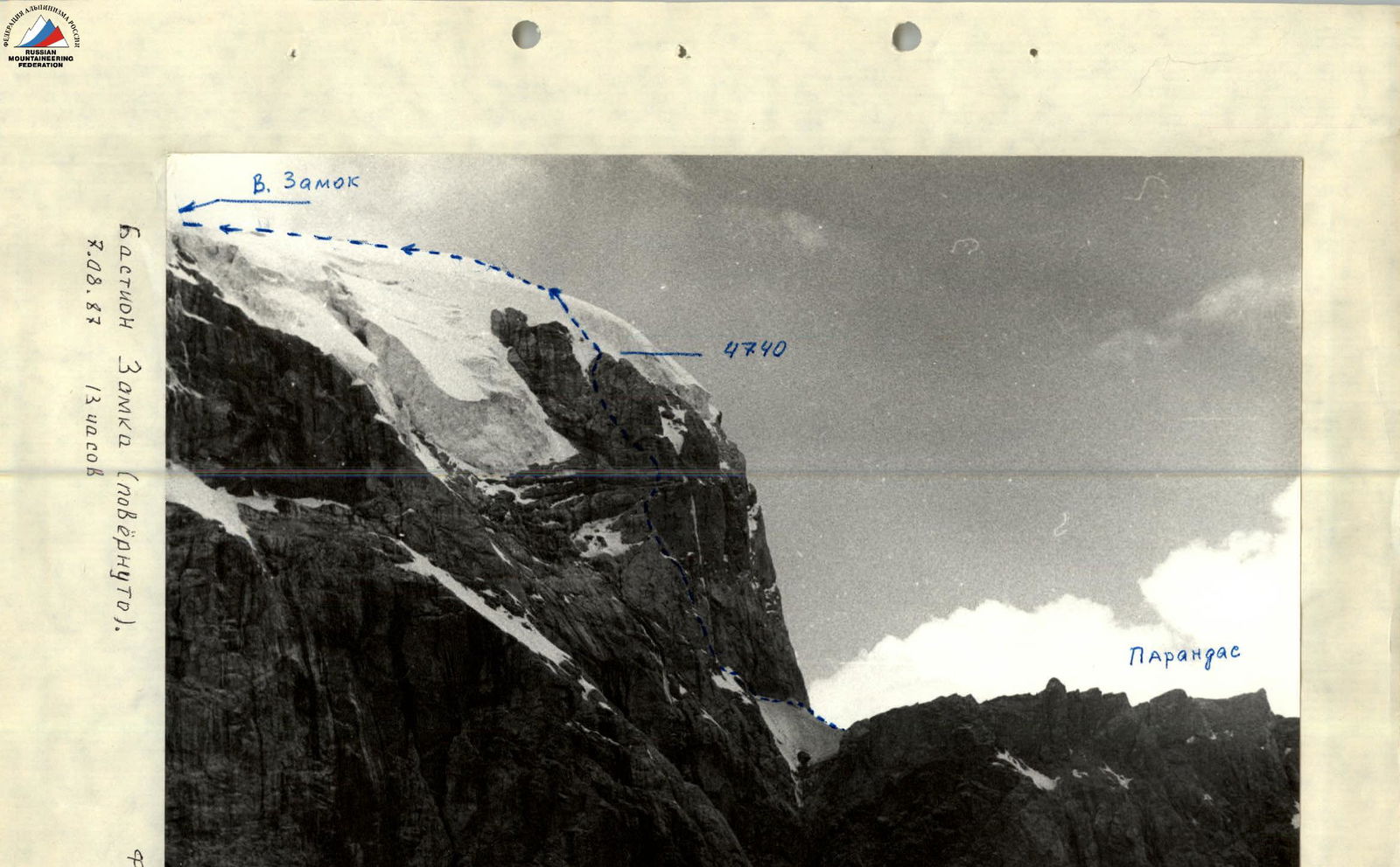
- R23–R24: along the ridge, 2 cat. diff., movement to the saddle between v. Parandas and v. Zamok.
- R24–R26: traverse for 160 m along a snow-ice slope to iced rocks. This section is recommended to be passed in the morning before sunrise.
- R26–R28: movement left-upwards along iced rocks of the bastion of v. Zamok using ice and rock equipment.
- R28–R33: movement along the left part of the rocky bastion to its summit.
- R33–R36: along an ice-snow slope.
- R36–R37: to v. Zamok.
Descent from v. Zamok via route 1B cat. diff.