PASSPORT
- Technical category.
- Fann Mountains. Zeravshan Range. /Northern part./ Alaudin Lakes.
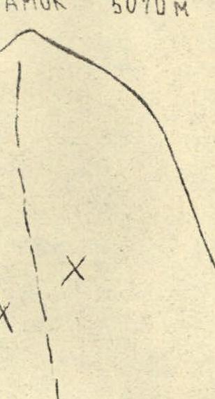
- p. Zamok (5070) via the right part of the northern wall of the "bastion"
- cat. III (Arkhipov's route)
- Height difference 1270 m, route length — 2142 m. Length of sections — R0–R1 cat. III — 851 m. Average steepness of the main part of the route — 78°
- Pitons used: rock — 111/32 chocks — 258/66 bolt — 1 ice screws — 20
- Team's working hours — 31 (3 days)
- Overnight stays — two
- Team leader and coach:
- Petyakiev Vasily Nikolaevich — CMS
- Spiridonov Alexander Semenovich — CMS
- Morozov Alexander Ivanovich — CMS
- Polokhov Vitaly Fedorovich — CMS
- Makoyev Viktor Viktorovich — CMS
- Tarasenko Vladimir Vladimirovich — CMS
- Departure to the route — July 9, 1990. Summit — July 11, 1990. Return — July 11, 1990.
- Organizing body: Rostov Regional Sports Committee.
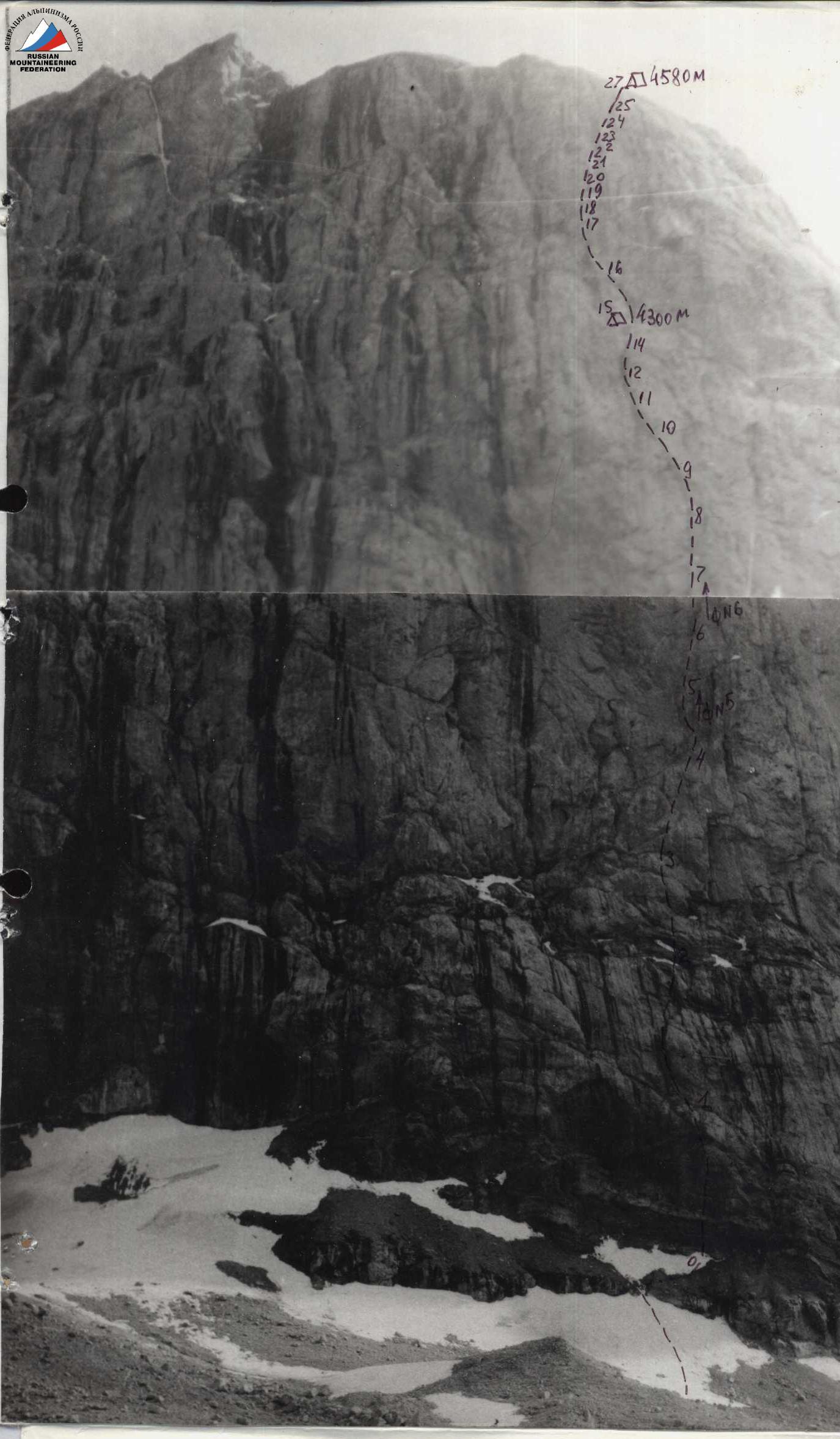
Technical Photograph of the Route
Team's route
Route section numbers R0–R27
Overnight stay location
Section photograph numbers № 5
July 04, 1990, 12:00. Lens T-43 LOMO, focal length = 4 cm.
Point № 4 (3800 m), distance to the object 1.0 km.
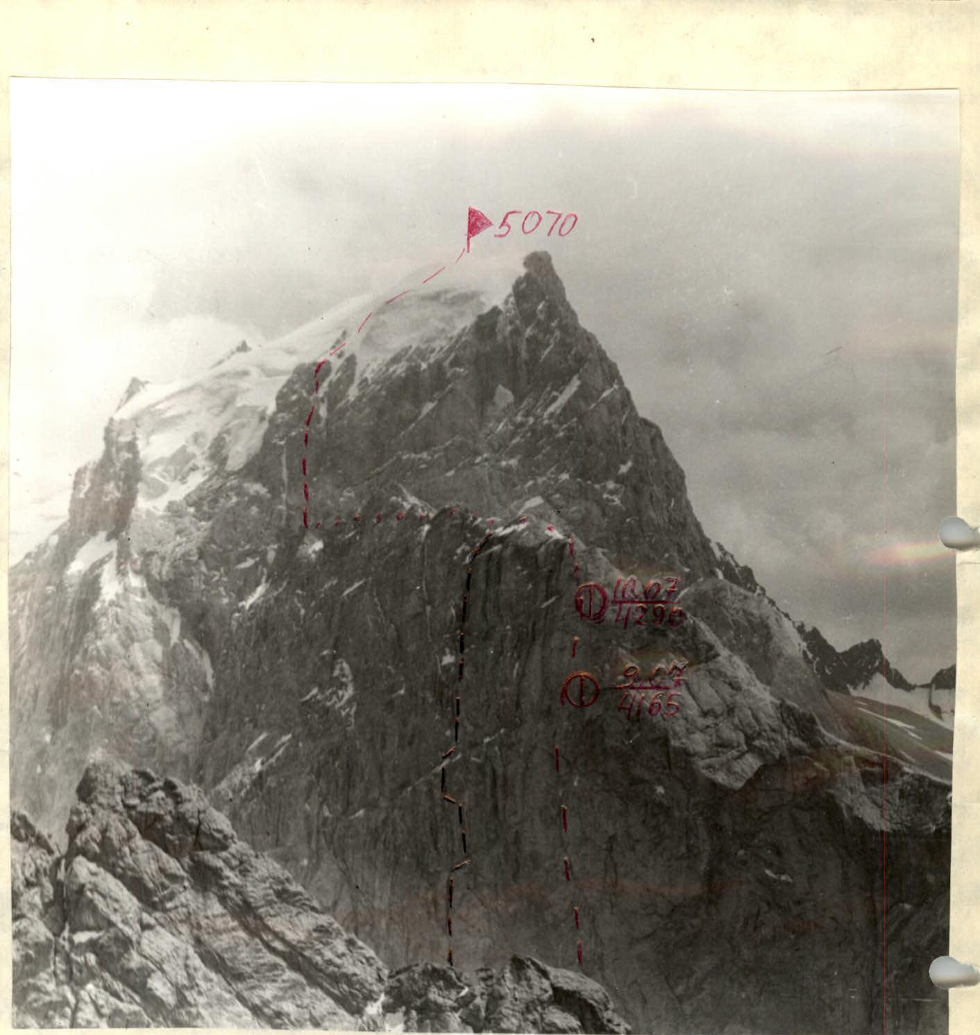
Photo № 1. General photo of the summit July 8, 1990. 18:00. Lens T-43, F = 40 mm. Distance to the object 1 km. Shooting height 4100 m. Shooting point № 1 — Tishchenko's Route — Arkhipov's Route
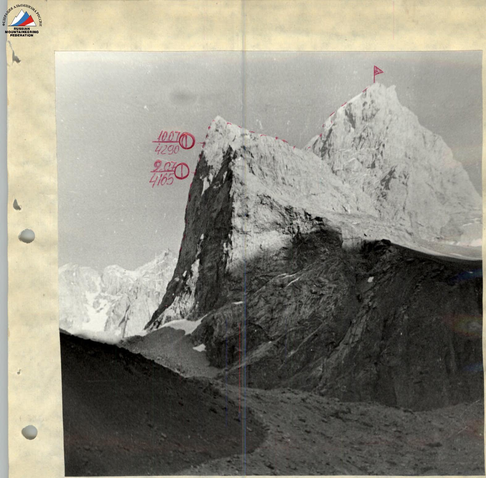
Photo № 2. Profile of the wall from the right. July 4, 1990. 18:00. Lens T-43, F = 40 mm.
- Distance to the object 800 m
- Shooting height 3600 m
- Shooting point № 2
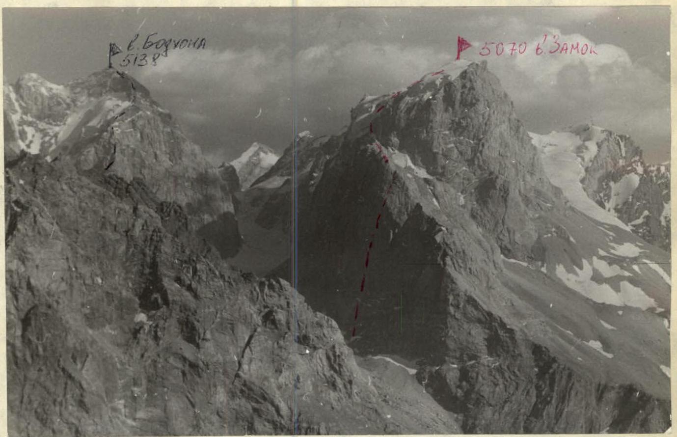
Photo № 3. Panorama of the area. July 28, 1990. 9:00. Lens "Zenitor", F = 50 mm. Shooting height 4200 m. Shooting point № 3 — Team's Route — Gulynev's Route
Team's Tactical Actions
Overall, the ascent was carried out according to the tactical plan. A slight deviation occurred on July 10, 1990, when the team did not reach p. Zamok as planned due to a sudden deterioration in weather. The next day, the team made up for the lost time, which amounted to 4 hours out of 28 planned working hours before the overnight stay, constituting less than 20% and within acceptable limits. The first climber worked on a double rope, one of which was UIAA, without a backpack. The movement of the other participants was carried out on double ropes with two karabiners and a "prusik" or with top rope belay. The first climber was belayed through an improved "bug" by Koshevnik. Sections impassable by free climbing, wet and icy rock sections were overcome using étriers and ladder segments for étriers. A belay station consisted of at least three belay points, blocked by a load-balancing loop.
The movement schedule is indicated in the team's tactical plan. Both overnight stays were organized in safe locations under overhangs.
Team's nutrition:
- Hot meals in the morning and evening.
- Dry rations during movement for each group.
There were no working falls, injuries, or frostbites.
Key sections of the route were:
- Section R18–R19 — overhanging, destroyed belt.
- Section R21–R22 — overhang with a black streak.
Physical preparation allowed the team to complete the route with a significant reserve in conditions of severe bad weather. Technical preparation corresponded to the route undertaken. In bad weather, the team acted cohesively and organized.
For monitoring the group and ensuring radio communication, a tent was set up on the glacier under the "Parakdas" bastion for observations. Observers had a radio station, binoculars, a tactical plan, and a diagram in UIAA symbols. A third radio station was located in the base camp. There were no radio communication disruptions. The rescue team was in the base camp.
| № | Item | Weight, kg |
|---|---|---|
| 1 | Sugar | 1.5 |
| 2 | Honey | 0.5 |
| 3 | Nuts | 0.5 |
| 4 | Prunes | 1.0 |
| 5 | Rusks | 2.0 |
| 6 | Sausage | 2.5 |
| 7 | Chicken broth | 0.72 |
| 8 | Chocolate | 0.6 |
| 9 | Tea | 0.2 |
| 10 | Cookies | 0.5 |
| 11 | Candies | 2.0 |
| Total: | 12.2 |
The group was provisioned with food at a rate of 0.677 kg per person. Additionally, for the case of "sitting out" bad weather, the group had an emergency supply consisting of:
- Freeze-dried soups — 0.72 kg (6 packs of 120 g)
- Bouillon cubes — 0.2 kg
- Chocolate — 0.2 kg
Total weight of provisions: 13.32 kg.
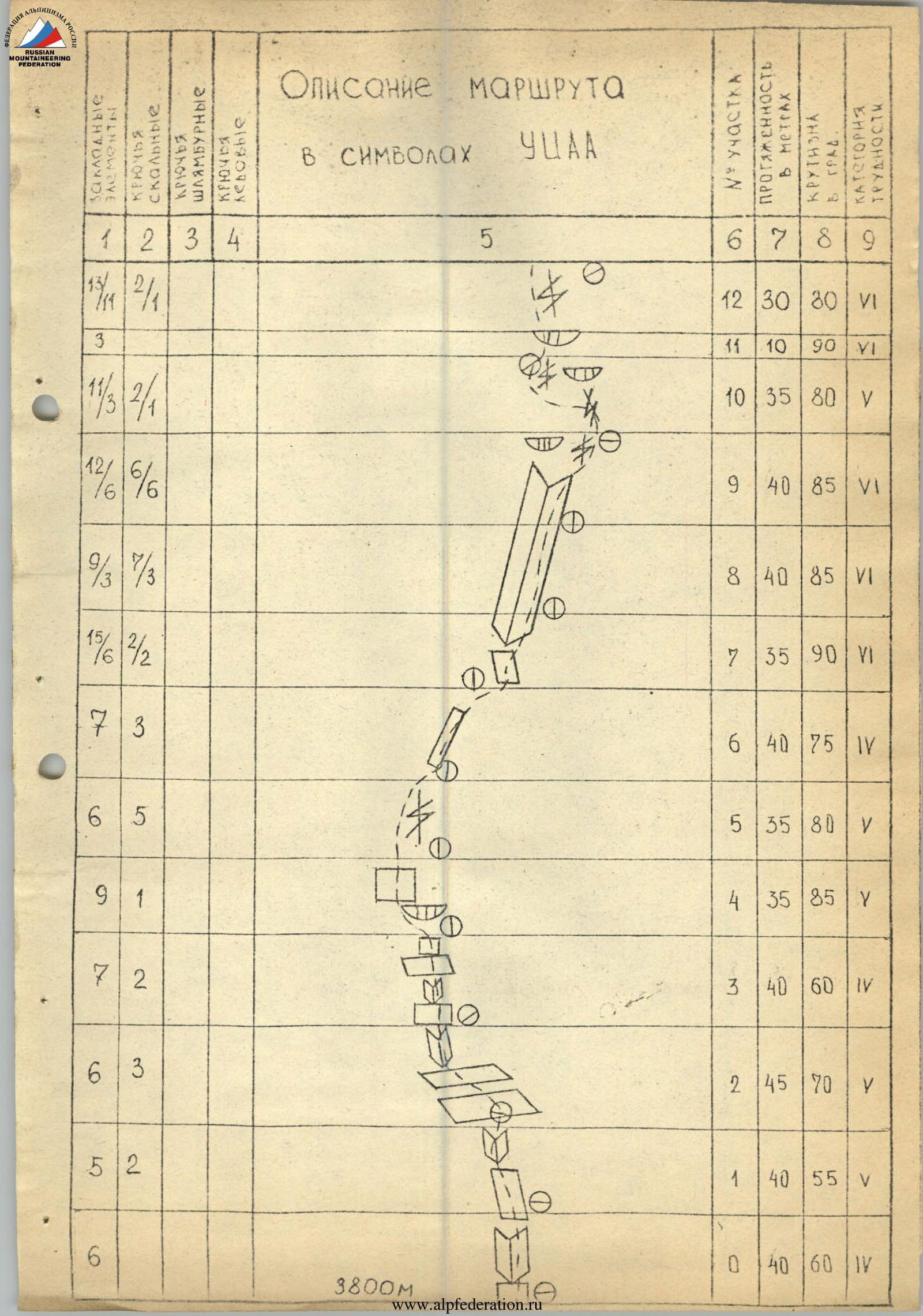
Route Description in UIAA Symbols
| Chocks | Rock | Bolt | Ice | Description/Notes | Section № | Length, m | Steepness, ° | Difficulty Category |
|---|---|---|---|---|---|---|---|---|
| 0 | 0 | 0 | 0 | (Diagram) | R39 | 100 | 45 | IV |
| 15 | 9 | 2 | 0 | (Diagram) | R38 | 160 | 50 | III |
| 0 | 6 | 6 | 0 | (Diagram) | R37 | 45 | 70 | V |
| 0 | 4 | 3 | 0 | (Diagram) | R36 | 50 | 30 | II |
| 0 | 10 | 1 | 0 | (Diagram) | R35 | 35 | 60 | V |
| 0 | 8 | 3 | 0 | (Diagram) | R34 | 40 | 60 | V |
| 3 | 3 | 2 | 0 | (Diagram) | R33 | 15 | 90 | V |
| 0 | 3 | 3 | 0 | (Diagram) | R32 | 25 | 60 | V |
| 0 | 2 | 6 | 0 | (Diagram) | R31 | 25 | 60 | V |
| 0 | 42 | 0 | 12 | Snow, ice | R30 | 160 | — | IV |
| 0 | 0 | 0 | 0 | Snow | R29 | 70 | 45 | III |
| 0 | 2 | 2 | 0 | (Diagram) | R28 | 20 | 45 | III |
| 0 | 8 | 4 | 0 | (Diagram) | R27 | 45 | 80 | V |
| 9 | 3 | 2 | 0 | (Diagram) | R26 | 30 | 65 | V |
| 0 | 0 | 0 | 0 | (Diagram) | R25 | 20 | 95 | VI |
| 0 | 0 | 0 | 0 | July 10. Working hours 9. Overnight stay 4290 m. | R24 | 6 | 50 | IV |
| 8 | 1 | 5 | 4 | (Diagram) | R23 | 40 | 20 | V |
| 9 | 2 | 3 | 3 | (Diagram) | R22 | 45 | 70 | V |
| 9 | 2 | 9 | 1 | (Diagram) | R21 | 15 | 95 | VI |
| 8 | 6 | 8 | 4 | (Diagram) | R20 | 30 | 70 | V |
| 0 | 6 | 0 | 0 | (Diagram) | R19 | 15 | 60 | V |
| 3 | 3 | 2 | 2 | (Diagram) | R18 | 6 | 120 | VI |
| 9 | 6 | 3 | 1 | (Diagram) | R17 | 13 | 85 | VI |
| 137 | 44 | 40 | 17 | July 9. Working hours 13. Overnight stay 4165 m. | R16 | 40 | 75 | V |
| 5 | 3 | 2 | 1 | (Diagram) | R15 | 20 | 90 | VI |
| 4 | 3 | 2 | 1 | (Diagram) | R14 | 15 | 90 | VI |
| 9 | 5 | 3 | 2 | (Diagram) | R13 | 25 | 80 | VI |
| 17 | 1 | 2 | 1 | (Diagram) | R12 | 30 | 30 | VI |
| 0 | 3 | 0 | 0 | (Diagram) | R11 | 10 | 90 | VI |
| 1 | 3 | 2 | 1 | (Diagram) | R10 | 35 | 80 | V |
| 12 | 6 | 6 | 6 | (Diagram) | R9 | 40 | 85 | VI |
| 9 | 3 | 7 | 3 | (Diagram) | R8 | 40 | 85 | VI |
| 17 | 6 | 3 | 2 | (Diagram) | R7 | 35 | 90 | VI |
| 0 | 7 | 3 | 0 | (Diagram) | R6 | 40 | 75 | IV |
| 0 | 6 | 5 | 9 | 0 | (Diagram) | R5 | 35 | 80 |
| 9 | 1 | 0 | 0 | (Diagram) | R4 | 35 | 85 | V |
| 0 | 7 | 2 | 0 | (Diagram) | R3 | 40 | 60 | IV |
| 0 | 6 | 3 | 0 | (Diagram) | R2 | 45 | 70 | V |
| 0 | 5 | 2 | 0 | (Diagram) | R1 | 40 | 55 | V |
| 0 | 6 | 0 | 0 | (Diagram) | R0 | 40 | 60 | IV |

p. Zamok 5070 m
| Chocks | Rock | Bolt | Ice | Description/Notes | Section № | Length, m | Steepness, ° | Difficulty Category |
|---|---|---|---|---|---|---|---|---|
| 0 | 0 | 0 | 0 | (Diagram) | R40 | 400 | 20 | I |
| 0 | 0 | 0 | 0 | (Diagram) | R39 | 100 | 45 | IV |
Route Description by Sections
The route starts under a clearly defined sheer internal corner, beginning 100 m above the start of the route, to the left of the main crack resembling a "dollar" sign. Movement is left-upwards through a black scree shelf to a crack left of the sheer internal corner, section R0–R5.
The route then goes 30 m up the crack, section R5–R6. Then right-upwards along an inclined shelf, section R6–R7, to a long, about 80 m, internal corner that ends in a cornice. Approach to the corner is 30 m along the wall, cat. III, section R7–R8. Further movement is along the internal corner with a cornice, section R8–R10. The upper part and the cornice are passed using ITO and rock pitons. Section R10–R11 goes 35 m along the main crack of the "dollar" to the next cornice, section R11. Exit onto the cornice is from the left — cat. III — and then over the cornice to the right to a crack where belay can be organized through chocks. Further movement is along a steep crack, section R11–R15, and exit onto a "finger" over which a cornice overhangs. The 1st control cairn-overnight stay is on a small shelf. Section R15–R16 — 40 m along the crack, approach along the cornice. The crack is partially filled with ice, using ice axes as belay points. The cornice is passed along the right part using ITO. After 40 m of movement along the crack, section R17–R18, the team approaches the next key section, an overhanging destroyed belt, section R18–R19, which is passed along a non-obvious crack, right of a large rusty destroyed corner, by alternating free climbing and ITO. Section R19–R26 passes along cracks filled with ice. Belay can be organized through ice screws. Approach under the overhang — sloping shelves — second overnight stay is organized.
The key location — an overhang with a black streak, section R21–R22, is passed right of the large black streak: first along a thin crack on the right using ITO, then straight up to a small shelf, section R22, 10 m to the right. Section R22–R23 — exit onto a large shelf under a steep chimney 45 m long, exiting onto the ridge, section R23–R24. Further movement is along the ridge for 2 km to the saddle between the "Parakdas" bastion and p. Zamok, section R24–R26. Section R26–R28 — Graves, 160 m along a snow-ice slope to icy rocks. Section R28–R33 — movement left-upwards along icy rocks of the bastion into "Zamok" using ice and rock equipment. Then movement along the left part of the bastion to its summit, section R33–R36, and along an ice-snow slope, section R36–R37, to p. Zamok. Descent from the summit "Zamok" is via route 1B category.