Ascent Passport.
- Ascent class — technical.
- Ascent area — Zeravshan Range, Fann Mountains.
- Peak Zamok 5070 m. Ascent route via the center of the northern wall of the Parandas bastion.
- Difficulty category — 6A.
- Route characteristics: Elevation gain – 1500 m. Length of sections with 5–6 diff. cat. – 390 m (5 diff. cat.), 340 m (6 diff. cat.). Average steepness of the wall section – 73° (from 3600 to 4200 m).
- Pitons driven: Rock pitons – 39, chocks – 181, ice screws – 22, bolt pitons – 0.
- Number of climbing hours – 52.
- Number of nights – 1, 2 – on a ledge, 3 – on the bastion ridge, 4 – near the summit.
- Participants: Vakula I.V. – Candidate Master of Sports Murygin O.V. – 1st sports category 482-16-04 home.
- Approach to the route – August 5, 2002, summit – August 10, 2002, return to camp – August 11, 2002.
- MEPhI Rock Climbing and Alpine Club – MALL "Vertikal – Alaudin" team.
Ascent diagram in UIAA symbols
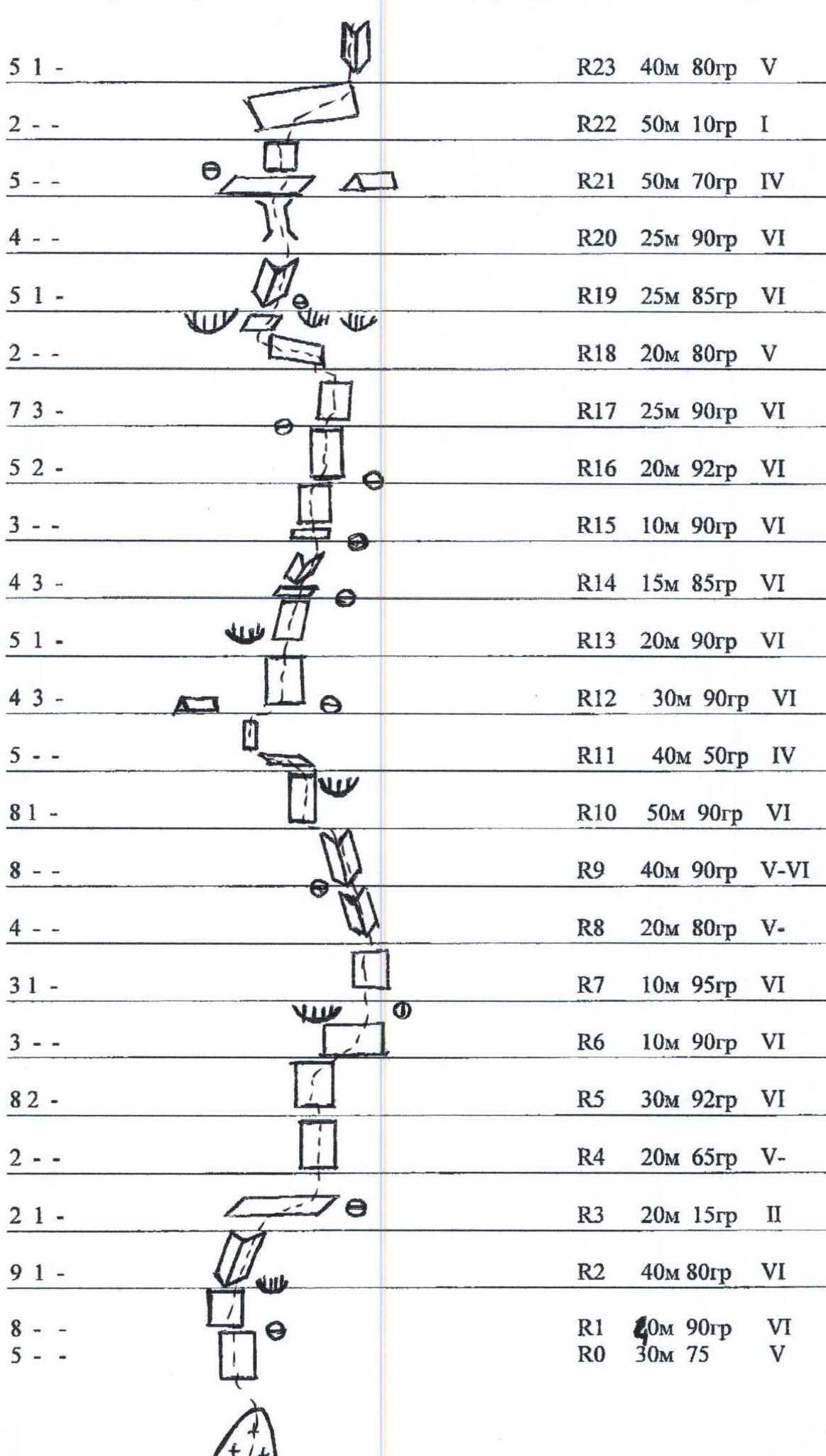
| Pitons | Section | Section characteristics |
|---|---|---|
| 8- | R48 | 400 m, 10° 1 |
| --4 | R47 | 50 m, 45° 3 |
| --4 | R46 | 25 m, 90° 5 |
| 214 | R45 | 25 m, 30° 4 |
| 41- | R44 | 10 m, 90° 6 |
| 3-- | R43 | 15 m, 30° 3 |
| -14 | R42 | 50 m, 50° 4 |
| 1-4 | R41 | 50 m, 50° 4 |
| 2-2 | R40 | 50 m, 50° 4 |
| 83- | R39 | 15 m, 92° 6 |
| 3-- | R38 | 60 m, 10° 3 |
| 42- | R37 | 10 m, 90° 6 |
| 2-- | R36 | 15 m, 15° 3 |
| 23- | R35 | 15 m, 65° 5 |
| 31- | R34 | 10 m, 90° 5 |
| 52- | R33 | 30 m, 70° 5 |
| 2-- | R32 | 40 m, 50° 4 |
| 2-- | R31 | 40 m, 60° 5 |
| 1-- | R30 | 15 m, 10° 3 |
| 82- | R29 | 40 m, 90° 6 |
| 32- | R28 | 20 m, 90° 6 |
| 2-- | R27 | 100 m, 30° 3 |
| 3-- | R26 | 20 m, 70° 4 |
| 41- | R25 | 30 m, 85° 5 |
| 1-- | R24 | 10 m, 10° 1 |
| 51- | R23 | 40 m, 80° 5 |
| 2-- | R22 | 50 m, 10° 1 |
| 5-- | R21 | 50 m, 70° 4 |
| 4-- | R20 | 25 m, 90° 6 |
| 51- | R19 | 25 m, 85° 6 |
| 2-- | R18 | 20 m, 80° 5 |
| 73- | R17 | 25 m, 90° 6 |
| 52- | R16 | 20 m, 92° 6 |
| 3-- | R15 | 10 m, 90° 6 |
| 43- | R14 | 15 m, 85° 6 |
| 51- | R13 | 20 m, 90° 6 |
| 43- | R12 | 30 m, 90° 6 |
| 5-- | R11 | 40 m, 50° 4 |
| 81- | R10 | 50 m, 90° 6 |
| 8- | R9 | 40 m, 90° 5–6 |
| 4-- | R8 | 20 m, 80° 5 |
| 31- | R7 | 10 m, 95° 6 |
| 3-- | R6 | 10 m, 90° 6 |
| 82- | R5 | 30 m, 92° 6 |
| 2-- | R4 | 20 m, 65° 5 |
| 21- | R3 | 20 m, 15° 2 |
| 91- | R2 | 40 m, 80° 6 |
| 8- | R1 | 40 m, 90° 6 |
| 5-- | R0 | 30 m, 75° 5 |
Team's Tactical Actions
The ascent of Zamok peak was made within the framework of the CIS championship during the MEPhI Alpine Club training camp in the Alaudin Lakes area (Fann Mountains). Previously, the team had made several ascents, including to Chapdara peak (5A diff. cat.). Consultations were obtained from the director of "Vertikal" base Arefieva R.G., as well as from representatives of the Russian-Tajik rescue expedition who had previously ascended the same peak via the Arkhipov route. Backup and observation were provided by a group of climbers from Riga.
On August 5, the team approached the route and observed it for the second half of the day. Based on the observation, it was concluded that the previously described start of the route was prone to rockfall and it was decided to climb directly from under the cornice. Additionally, it was decided to:
- Climb 4–5 ropes
- Descend to the glacier
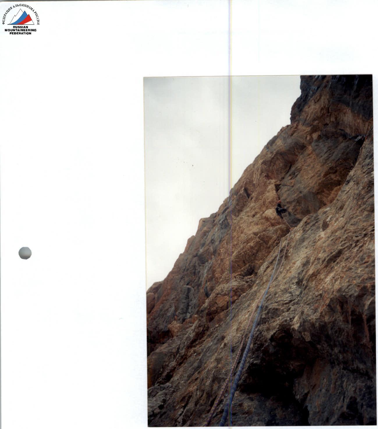
On August 6, the team approached the route by 8:00. After 40 m of difficult climbing, they reached a steep wall, partially overhanging, leading to a large cornice. The cornice is bypassed on the left via a very difficult inner corner with an overhang in the middle section. Climbing is complicated by water flowing down the corner. The corner leads to a wide, sloping ledge about 50 m long. Moving 20 m to the right along the ledge, they climbed up easy rock to the base of a complex wall (stand-by piton, key point of the lower section of the route).
On August 7, having passed the ropes hung the previous day by 8:00, the team began to climb the wall. The wall overhangs and is climbed using artificial aids (I.T.O.), leading to a cornice. From under the cornice – a tense traverse to the right (no belay points), then up a steep, broken wall directly to the base of an inner corner. A convenient belay point. Up the inner corner to the left – up to an ice-filled flake. At this point, the leader decided not to climb the flake but to climb left through the cornice and up a complex wall to a large ledge. Moving along the ledge with one wall to the left, the team found a convenient place to bivouac, protected from falling rocks.
On August 8, the team began to move, climbing a complex wall leading to a cornice. The cornice is bypassed on the right, and then – up a complex wall to a wet crack (I.T.O.). Then up a complex wall to large cornices, which are passed on the left. Exit to a ledge with a convenient bivouac.
On August 9, the team climbed the upper part of the wall, gradually easing. Steep inner corners, filled with ice, alternated with ledges, with an overall direction up – to the left. By the end of the day, the team reached the bastion ridge and, moving left along it, bivouacked at the base of the Zamok peak wall.
On August 10, after climbing 200 m of a steep left slope (ice screws), then via a system of ledges and ice-filled cracks and inner corners (ice axes), the team reached a simple snow slope leading to Zamok peak. Bivouac near the summit.
On August 11, descending from the summit via an easy route (2A), the team returned to the camp at Alaudin Lakes by 17:00.
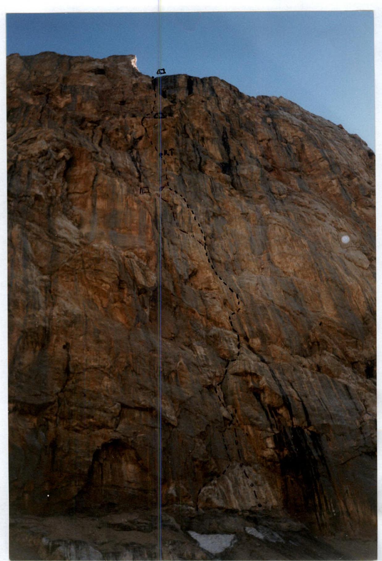
Rocky part of the route (Parandas Bastion)