Ascent Passport
-
Ascent class — technical.
-
Ascent area, ridge — Fan Mountains, Zarafshan Ridge.
-
Peak, its height, ascent route: peaks MARIIA (4970 m), MIRALI (5120 m), PROMEZHUTOCHNAYA (4810 m), ADAMTASH (4700 m), traverse with ascent to peak MARIIA via NW buttress, 2nd passage of the route.
-
Proposed difficulty category — 5B.
-
Route characteristics:
Total elevation gain — about 2600 m. Elevation gain on peak Mariya via NW buttress — 1250 m, including 700 m of wall. Length of sections with 5-6 difficulty category — 500 m. Average steepness of the entire route — 45°. Average steepness of the wall section of the buttress — 65°.
-
Number of pitons driven:
rock pitons — 95, including 3 for creating TAE chockstones — 30, including 1 for TAE ice screws — 5
-
Number of walking hours — 33
-
Number of bivouacs and their characteristics:
Two — good, on the ridge.
-
Participants' full names and qualifications:
Babeshko V.P. — CMS Valiulin E.A. — CMS
-
Team coach: Mumdzhi T.M., MS USSR, instructor-methodologist 1st category.
-
Date of departure and return:
Departure — August 24, 1980, return — August 26, 1980.
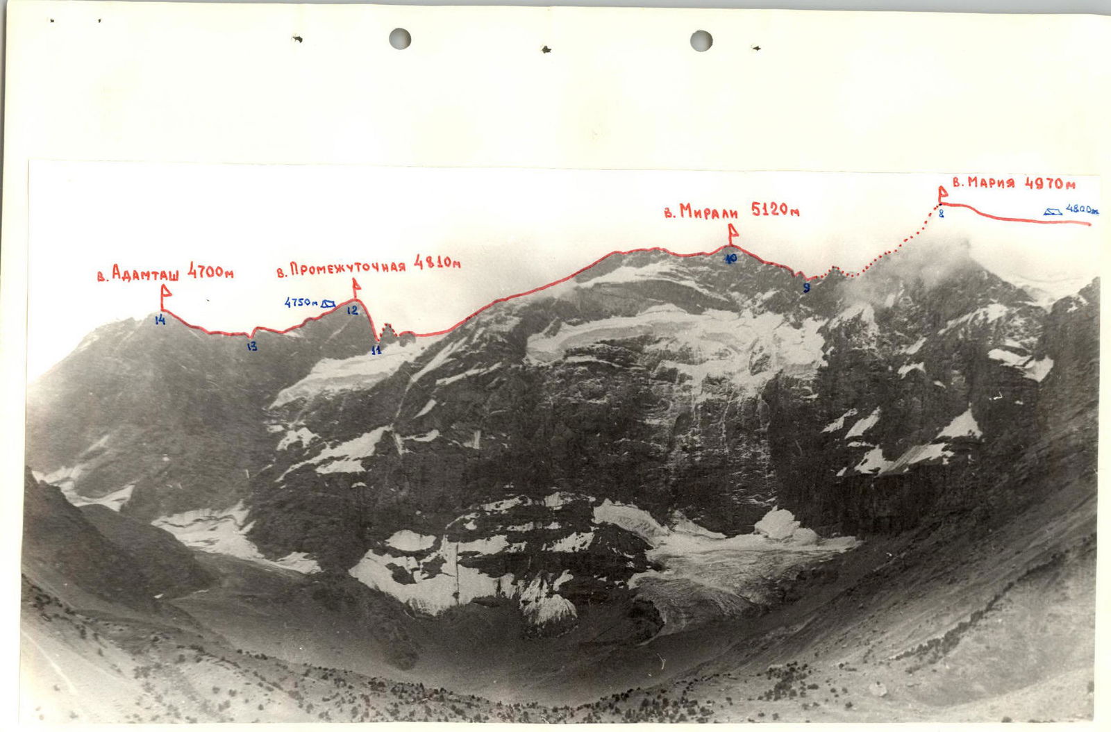
Traverse of peaks Mariya — Adamtash.
- ROUTE VIA NW BUTTRESS PASSED BY THE GROUP — ASCENT ROUTE DURING TRAVERSE OF PEAKS MARIYA — ADAMTASH 5B DIFFICULTY CATEGORY.
- ROUTE VIA S. BUTTRESS OF W. RIDGE, 5B DIFFICULTY CATEGORY TO PEAK MARIYA.
- ROUTE VIA S. WALL OF W. RIDGE, 5B DIFFICULTY CATEGORY TO PEAK MARIYA.
- ROUTE VIA S. RIDGE, 4B DIFFICULTY CATEGORY TO PEAK MARIYA.
ROUTE VIA NW BUTTRESS TO PEAK MARIYA (ascent route during traverse of peaks MARIYA — ADAMTASH).
Table of main route characteristics
| Date | Section designation | Average steepness in ° | Length in m | Terrain type | Difficulty | Condition | Weather conditions | Rock pitons | Chockstones | Ice screws | Time of departure and bivouac stop, number of walking hours, bivouac conditions. Time of reaching the summit. |
|---|---|---|---|---|---|---|---|---|---|---|---|
| 24.08. | R0–R1 | 55 | 50 | wall | 4 | broken | good | 5 | 1 | – | Departure – 6:00. Stop – 22:00. Walking hours – 16. |
| R1–R2 | 70 | 150 | wall | 5 | monolith | 15 | 5 | – | |||
| R2–R3 | 65 | 70 | wall | 5 | monolith | 7 | 3 | – | |||
| R3–R4 | 50 | 130 | ridge | 4 | monolith | 8 | 2 | – | |||
| R4–R5 | 60 | 120 | wall | 4 | broken | 6 | 3 | – | |||
| R5–R6 | 65 | 180 | wall | 5 | monolith | 12 | 6 | – | |||
| R6–R7 | 45 | 600 | ridge | 4 | ice, firn | 4 | 1 | 3 | |||
| R7–R8 | 40 | 400 | ridge | 4 | monolith | 8 | 3 | – | Reaching peak Mariya – 21:00. | ||
| 25.08. | R8–R9 | 30 | 800 | slope | 2 | broken | good | – | – | – | Departure – 8:00. |
| R9–R10 | 45 | 400 | ridge | 2 | broken | – | – | – | Reaching peak Mirali – 11:00. | ||
| R10–R11 | 45 | 300 | ridge | 4 | ice, firn | 2 | – | 2 | |||
| R11–R12 | 80 | 60 | wall | 6 | monolith | 12 (2*) | 5 (1*) | – | Reaching saddle Promezhutochny – 20:00. Stop – 21:00. Walking hours – 13. | ||
| 26.08. | R12–R13 | 45 | 350 | ridge | 4 | monolith | good | 4 | – | – | Departure – 8:00. |
| R13–R14 | 30 | 300 | ridge | 2 | broken | – | – | – | Reaching peak Adamtash – 13:00. Stop time – 13:00. Walking hours – 5. |
* Used for creating TAE.

Brief explanation of the table
Approach to the start of the route from Lake Bibidzhannat of Kulikalonsky circus takes 2–2.5 hours.
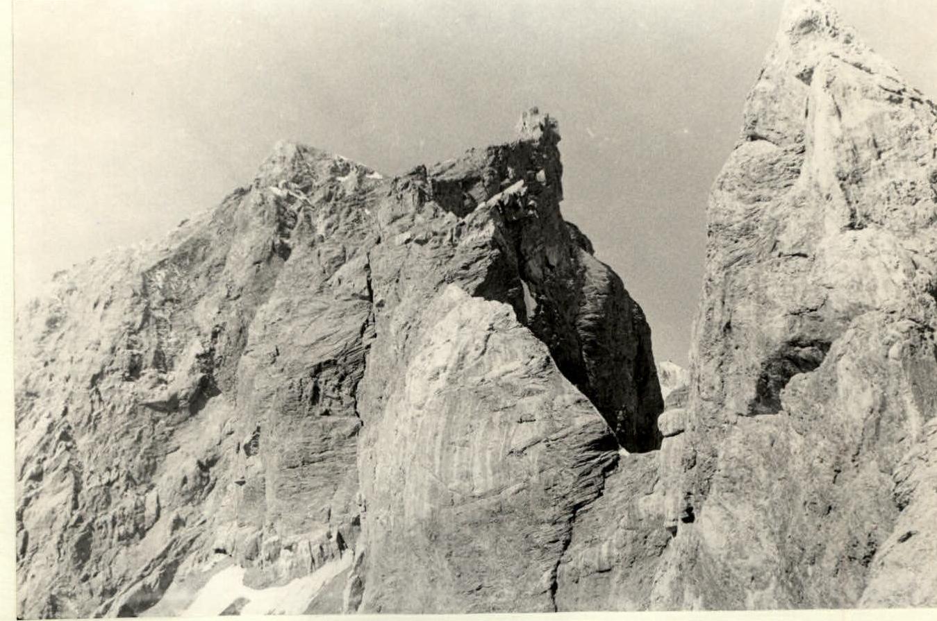
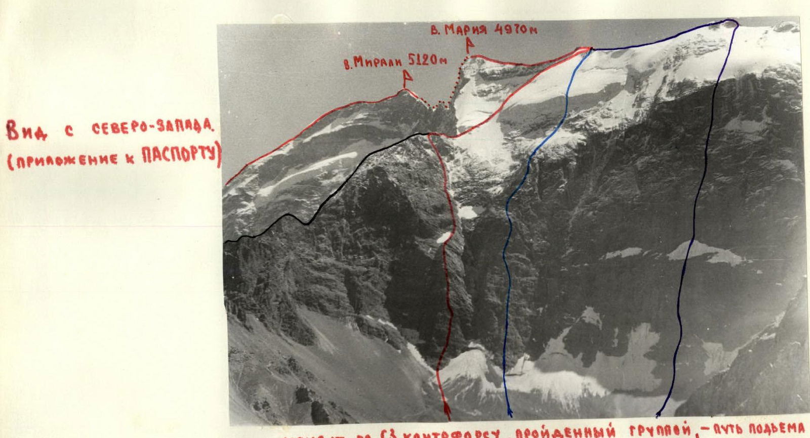
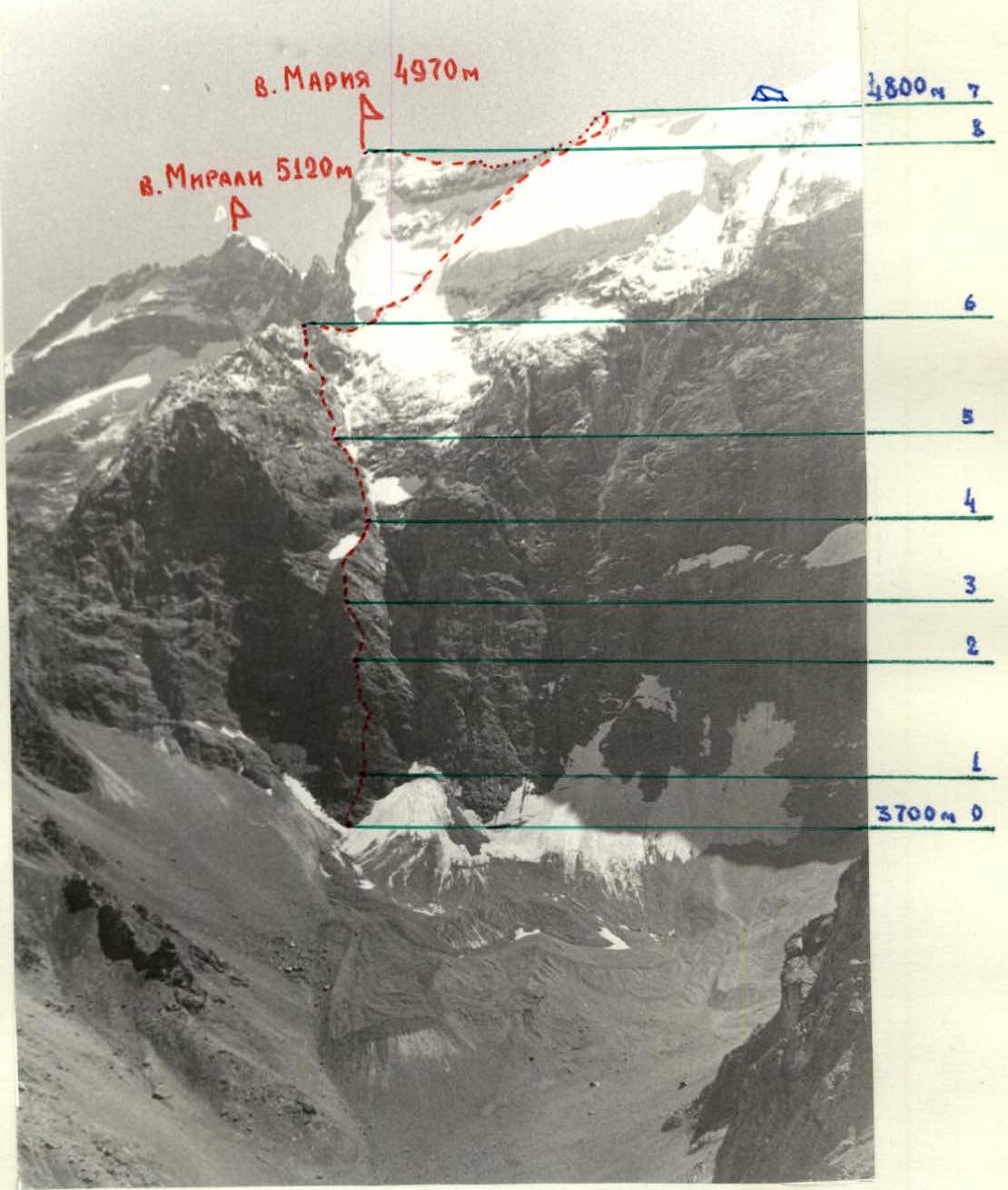
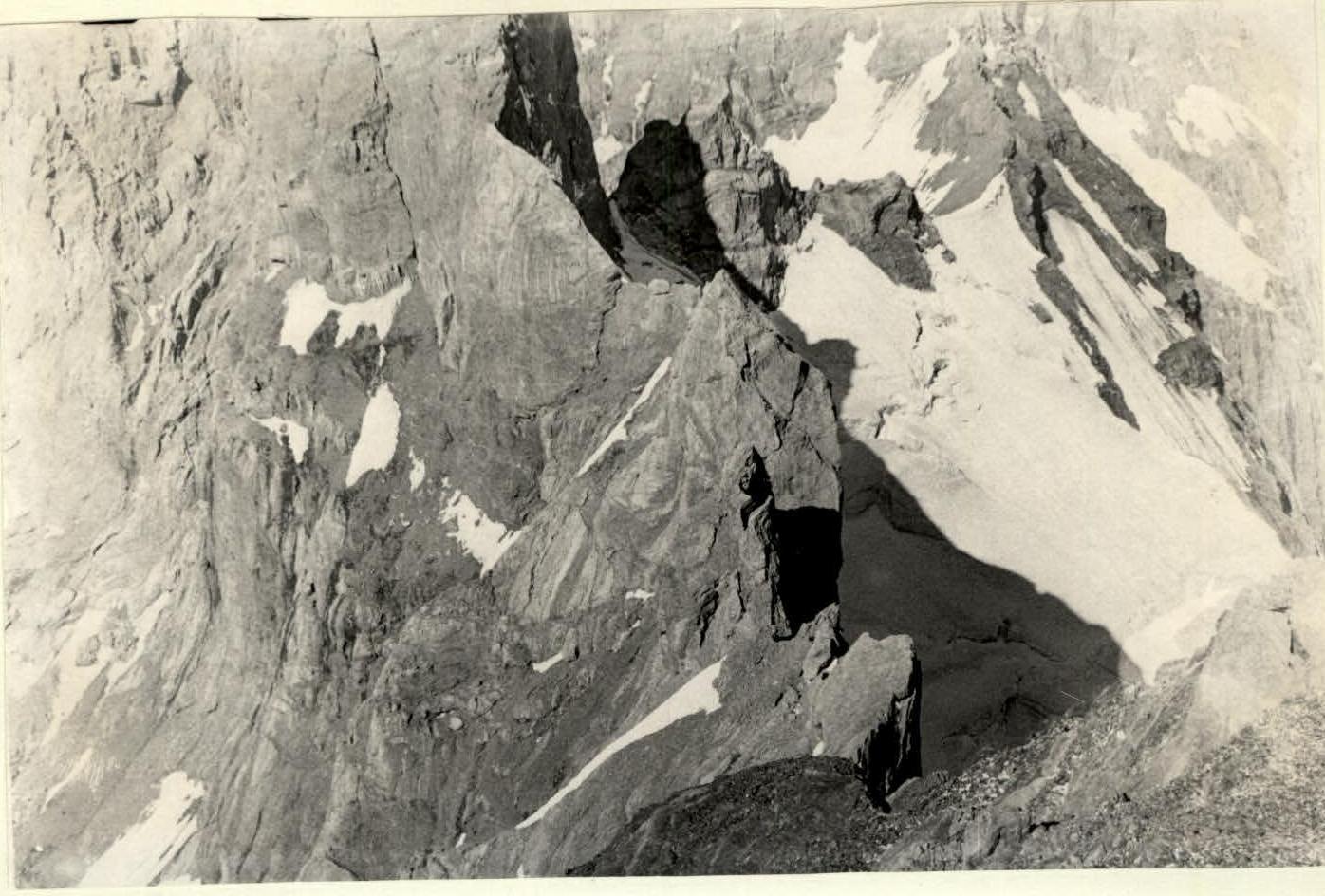
Start of the route — a clearly defined NW-directed buttress leading to the gendarme Temirtau on the northern ridge of peak Mariya.
Section R0–R1: Up the broken wall of the buttress, sticking to its right part, to a scree inclined terrace — a hollow.
Section R1–R2: Bypassing the hollow from left to right, up steep dark grey rocks, sticking to the right edge of the buttress. Then left along a ledge under an overhanging black wall and again up the wall to a large rock ledge.
Section R2–R3: From the ledge, vertically up an internal corner, then up a vertical chimney to a clearly defined ridge.
Section R3–R4: Up the rock ridge until it merges with a large couloir separating the NW buttress from the N. wall of the W. ridge of peak Mariya.
Section R4–R5: Up the wall along an ice-filled gully-couloir via broken light grey rocks.
Section R5–R6: Left up from the couloir, up the wall towards the summit of gendarme Temirtau. Rocks are fairly monolithic, with much accreted ice.
Section R6–R7: Further along the ice-snow N. ridge, partly on rocks, to peak Uzlovaya on the W. ridge of peak Mariya.
Section R7–R8: Along a simple ridge to a steep rock shoulder. Overcoming it, along a broken ridge to the summit of Mariya.
Section R8–R9: Descent from the summit along the W. ridge, then left down, bypassing the summit, to below peak Mirali.
Section R9–R10: Along a broken simple ridge to peak Mirali.
Section R10–R11: Along a rock ridge, then along a snow-ice ridge, bypassing peak Mirali, descent to saddle Promezhutochny.
Section R11–R12: Ascent to saddle Promezhutochny via a steep monolithic wall. This is one of the most technically challenging sections of the entire traverse.
Section R12–R13: Along a heavily dissected monolithic ridge, descent to peak Adamtash.
Section R13–R14: Along a simple ridge, ascent to peak Adamtash.
There were two bivouacs on the route: the first below peak Mariya, the second on saddle Promezhutochny. Apart from the ascent via NW buttress to peak Mariya (corresponding to 5A difficulty category), the technical difficulty of the traverse includes sections:
- Descent from peak Mirali (corresponding to 4 difficulty category)
- Ascent to saddle Promezhutochny (corresponding to 6 difficulty category)
- And descent from it (corresponding to 4-5 difficulty category).
Sections of descent from peak Promezhutochnaia.