Ascent Passport
I. Ascent class — technical. 2. Ascent area, ridge — Fan Mountains, Zarafshan Ridge. 3. Peak, its height, ascent route — Mt. Maria, 4970 m, via the north buttress of the western ridge, first ascent. 4. Proposed difficulty category — 5B. 5. Route characteristics: length of sections with 5–6 difficulty category — 940 m; total height difference of the entire route — 1670 m; average steepness — 53°; height difference of the buttress itself — 1450 m; average steepness — 62°; height difference of the rocky part of the buttress — 850 m; average steepness — 70°. 6. Pitons driven: rock — 152, ice — 37. 7. Number of nights and their characteristics — 3, safe and comfortable nights. 8. Total climbing hours — 32.5. 9. Surname, name, patronymic of the leader, participants, and their qualifications: Mumdzhi Timur Memetovich — Candidate for Master of Sports, leader Golubev Nikolai Nikolaevich — Candidate for Master of Sports Parkhimenko Alexander Leonidovich — Candidate for Master of Sports Valiulin Eduard Alexandrovich — 1st sports category Volkov Valery Timofeevich — 1st sports category Yakubenko Viktor Konstantinovich — 1st sports category. 10. Team coach — Mumdzhi Timur Memetovich. II. Date of departure and return: departure on the route — August 10, 1978, return — August 13, 1978.
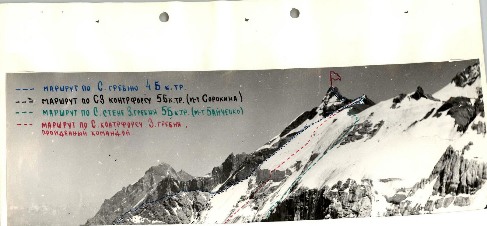
- Route via N ridge, 4B category.
- Route via NW buttress, 5B category (Sorokin's route).
- Route via N wall of W ridge, 5B category (Baichenko's route).
- Route via N buttress of W ridge, ascended by the team.
Route profile
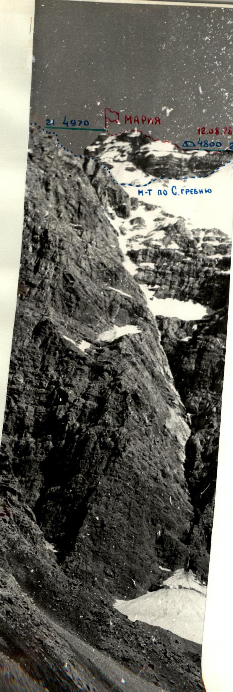
Table of main route characteristics
| Date | Designation | Average steepness | Length | Terrain character | Difficulty | Condition | Weather conditions | Rock pitons | Ice pitons | Time of departure and stop at bivouac | Total time of climbing hours, excluding rest, food, etc. | Bivouac conditions |
|---|---|---|---|---|---|---|---|---|---|---|---|---|
| August 10, 1978 | R0–R1 | 50° | 120 m | Slope | 4 | destroyed | good | 8 | — | from 7:00 to 14:00 | 7 hours | Good, on moraine under the route. |
| R1–R2 | 70° | 85 m | Edge | 5 | monolith | — | 12 | — | ||||
| R2–R3 | 75° | 100 m | Wall | 5 | monolith | — | 14 | — | ||||
| R3–R4 | 85° | 45 m | Wall | 6 | monolith | — | 12 | — | ||||
| August 11, 1978 | R4–R5 | 70° | 35 m | Ledge | 5 | monolith | — | 5 | — | (end of section — next bivouac site) | ||
| R5–R6 | 75° | 45 m | Wall | 6 | monolith | — | 8 | — | ||||
| R6–R7 | 80° | 40 m | Wall | 6 | monolith | — | 9 | — | ||||
| R7–R8 | 75° | 100 m | Wall | 5 | destroyed | — | 10 | — | ||||
| R8–R9 | 45° | 70 m | Wall | 5 | monolith | — | 6 | — | ||||
| R9–R10 | 85° | 40 m | Wall | 6 | monolith | — | 8 | — | ||||
| R10–R11 | 70° | 60 m | Edge | 5 | monolith | — | 9 | — | ||||
| R11–R12 | 60° | 80 m | Edge | 5 | monolith | — | 10 | — | ||||
| R12–R13 | 85° | 30 m | Edge | 6 | monolith | — | 8 | — | ||||
| R13–R14 | 70° | 30 m | Edge | 5 | monolith | — | 6 | — | ||||
| R14–R15 | 30° | 30 m | Ledge | 3 | monolith | — | 2 | — | ||||
| R15–R16 | 45° | 100 m | Slope | 4 | icy | — | 5 | — | from 7:00 to 21:00 | 12 hours | Good, on a wide ledge. | |
| R16–R17 | 70° | 120 m | Wall | 5 | monolith | — | 12 | — | ||||
| August 12, 1978 | R17–R18 | 85° | 60 m | Ice wall | 6 | icefalls | — | 18 | 7 | from 6:30 to 18:30 | 12 hours | Good, on a wide rocky ledge. |
| R18–R19 | 45° | 400 m | Ice-firn slope | 4 | dense | — | 12 | — | ||||
| R19–R20 | 30° | 400 m | Ridge | 2 | monolith | — | simultaneou | — | ||||
| August 13, 1978 | R20–R21 | 50° | 200 m | Ridge | 4 | destroyed | — | 8, ledges | — | from 8:00 to 9:30 | 1.5 hours | ascent to the summit. |
Brief explanation
To the table of main route characteristics
Preliminary inspection of the north buttress from the north ridge of Mt. Maria, as well as studying it from below with binoculars, showed that there are practically no convenient bivouacs on the buttress until the exit to its top — the "tooth" under the base of the ice barrier of the northern slopes of the western ridge of the peak. Therefore, it was decided to process 250–300 m of rocks in the lower part of the buttress on the first day in order to reach the "tooth" on the next day.
- On the first day, process 250–300 m of rocks in the lower part of the buttress.
- On the next day, reach the "tooth".
August 10. From the bivouac on the moraine to the glacier to the beginning of the north buttress — 15 minutes.
Section R0–R1: Up the edge of the buttress vertically. Rocks are destroyed, slightly above average difficulty. Insurance through pitons. General direction of movement — towards the top of the cone-shaped rocky triangle, clearly visible from below.
Section R1–R2
The rocks become significantly steeper, climbing becomes more complicated. Movement is still vertically upwards with piton insurance to the base of the right face of the cone-shaped triangle.
Section R2–R3
- Up the right face of the triangle to its top — 35 m.
- Then up the wall, then along the steep outer corner and again up the wall — under the cornice — 40 m.
Climbing is difficult, holds are small, like tiles. Insurance (here and further) is through pitons.
Section R3–R4
- Through the cornice 4 m up to the wall in its right part, and up the wall.
- Exit to a large ledge-terrace — 40 m. Very difficult, steep. But the rocks are monolithic with good holds.
About 350 m have been passed. We descend down the hung ropes to spend the night at the bivouac on the moraine.
August 11. We ascend via the ropes to the end of section R3–R4.
Section R4–R5:
- Along the ledge to the left under the cornice, crossing the groove, to a vertical chimney.
- Up the chimney 4 m.
- Then up the wall 30 m to a rocky ledge leading to the base of a large spalled block.
Section R5–R6
- From under the block, going around it on the left along the wall 5–7 m, exit to a steep inner corner (10 m), leading under the cornice.
- Along the slab to the left part of the cornice and through it to the wall — 5–7 m.
- Climbing is very difficult, holds are few.
- Up the wall 20 m to a rocky ledge.
Section R6–R7
- Again up the wall 15 m under a large cornice.
- Under the cornice to the right along a steep slab 10 m to a sheer monolithic wall.
- Up the wall 15 m and exit to a ledge under a "window" in the cornice.
- Climbing is very difficult.
Section R7–R8
- From the ledge under the cornice to the right of the "window", then traverse to the left and exit under the cornice — 20 m.
- Another 20 m of difficult climbing through the cornice and along the wall.
- Along them 40 m to the wall, to the right of which on the wall is a large red spot, clearly visible from below.
Section R8–R9. Up 40 m along steep rocks to the left along the path from the red spot to a small ledge under an overhanging wall.
Section R9–R10. Then up the wall 25 m, then along the inner corner and overhanging wall 15 m — exit to the top of the wall. Climbing is very difficult.
Section R10–R11. 40 m to the left up to the left edge of the wall. Up the wall 10 m (very difficult!), then along the slab and inclined crack 40 m — exit to the rocky edge of the buttress.
Section R11–R12 along the steep monolithic edge of light grey color upwards 80 m. Climbing is difficult, holds are few.
Section R12–R13
- Then vertically up along a narrow sheer chimney 20 m.
- To the left along a steep smooth slab 10 m.
We reach the middle of the pre-summit tower of the buttress. Climbing is very difficult, but the rocks are strong, monolithic.
Section R13–R14
- Then along an inclined crack to the left upwards 20 m.
- Along a monolithic wall 10 m.
Exit to the top of the buttress, to the "tooth".
Section R14–R15 — a gentle monolithic ridge (30 m), leads to a large rocky terrace.
The buttress itself has ended. It is followed by a small (4–5 m) dip and then steep smooth slabs, the path along which leads to the base of the sheer ice wall of the covering glacier of the western ridge of Mt. Maria.
A bivouac is organized on the rocky terrace. The 1st control cairn is also set up here. However, there is still plenty of daylight, and we decide to process the section from the bivouac to the ice wall after a short rest.
Section R15–R16:
- From the overnight site a little down.
- Exit to slabs like "ram's foreheads", partially snow-covered.
- Along them 100 m upwards.
- Pitons are driven poorly.
- Maximum care is required.
Section R16–R17
The rocks become significantly steeper and technically more complicated. Holds and cracks are few, with places having accrued ice. Up the steep slabs vertically 120 m to a small site under a rocky canopy directly at the base of the ice wall.
The 2nd control cairn is set up here (a tin can with a note is hung on a rocky pitons).
It's already getting dark. Leaving the hung ropes, we descend down to spend the night on the "tooth".
August 12, 1978. We ascend via the ropes to the base of the ice wall.
Section R17–R18
Vertically up along the sheer ice wall, using ice pitons for insurance, and for passage:
- screw-in pitons,
- ladders,
- ice axe,
- ice hammer.
The length of the section is 60 m. Climbing is very difficult.
Section R18–R19
Along the ice-firn slope alternately, organizing insurance through ice pitons, we exit to Mt. Maria-Uzlовая on the western ridge of Mt. Maria.
Section R19–R20
Along a gentle rocky ridge simultaneously, in places alternately in the direction of the pre-summit ascent.
Before the pre-summit rocky wall on a wide rocky ledge, a bivouac is organized.
August 13. Section R20–R21
Overcoming the rocky wall 15–20 m along the strongly destroyed rocky ridge, using ledges and pitons for insurance, exit to Mt. Maria.
Descent from the summit along the northern ridge via the route of 4B category.