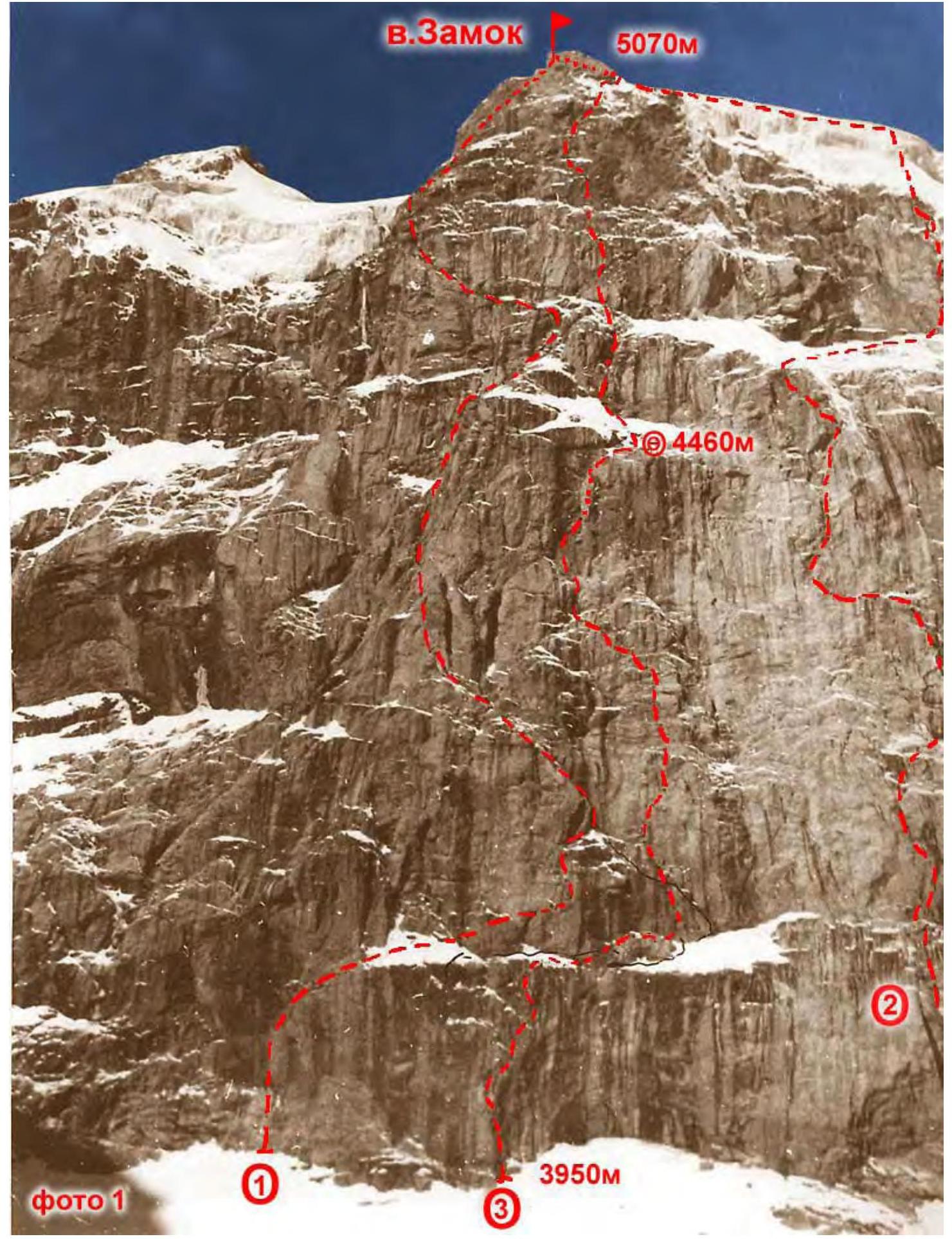
V. Zamok, 5B, via the shortest path up the NNE wall (A. Plotnikov's route, 82)
Climbing Passport
- Climbing category — technical
- Climbing area — Pamir-Alai. Eastern Fan Mountains, Zamok peak (5070 m) — via the shortest path up the NNE wall
- Proposed complexity category — 5B
- Height difference of the wall section — 950 m. Length of the wall section — 1115 m. Total route length — 1675 m. Length of sections with V–VI category difficulty — 690 m, including VI category — 275 m. Average wall slope — 67°
- Pitons driven:
| Pitons driven | For belay | ITO |
|---|---|---|
| Rock | 111 / 5 | 1 |
| Chocks | 115 / 5 | 0 |
| Bolt | 2 | 0 |
| Ice | 1 | 0 |
- Team's climbing hours: 20.5 hours (2 days)
- Overnight stays: lying in a tent. The overnight stay was set up by the team.
- Team: AUSV "Varzob" 7 A VS DFFSO "Profsoyuzov"
- Leader: Rusyaev Alexey Vasilievich — MS
Participants:
- Igolkin Viktor Ivanovich — MS
- Kirievsky Gennadiy Pavlovich — CMS
- Lapko Alexander Vladimirovich — CMS
- Odintsov Alexander Nikolaevich — MS
- Rykshin Vladimir Veniaminovich — CMS
- Team coach: — MS USSR Glushko Vyacheslav Ivanovich
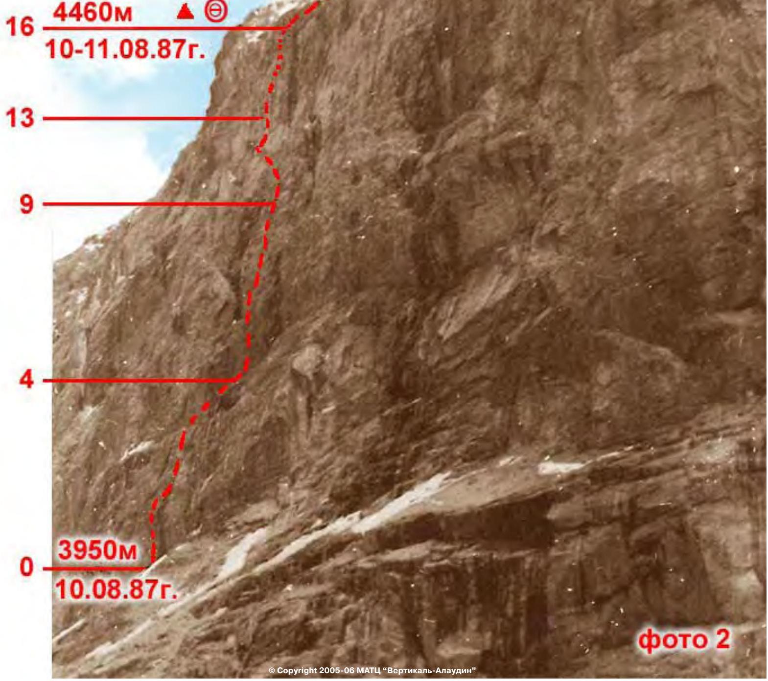
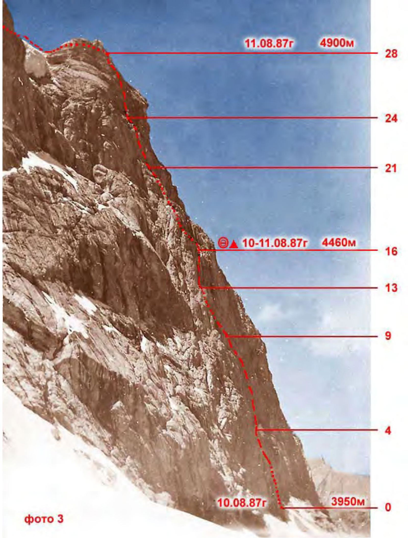
- Start of the route: August 10, 1987.
Reached the summit: August 11, 1987. Return: August 11, 1987.
Tactical Actions of the Team
The start date of the ascent — August 10, 1987 — was determined by the schedule of the USSR Championship, as well as the need to coordinate actions with the team from the Moldavian SSR, climbing a parallel route (a variation of the Shramko route). On August 8, 1987, a weather forecast was received via radio communication, indicating deteriorating weather on August 10–11, 1987, prompting the team to prepare a three-variant tactical plan. The plan accounted for different degrees of weather deterioration and route conditions, as well as reserve equipment and supplies. Due to normal weather conditions (weather deterioration occurred 2 hours before reaching the summit), the first variant of the tactical plan was executed. This variant involved completing the route with one overnight stay above the middle of the wall section and reaching the summit on the second day at 17:00.
In case of bad weather:
- The second variant involved two overnight stays (under the "finger" and under the upper bastion);
- The third variant — three overnight stays, if it became necessary to navigate through icy rocks in poor weather conditions.
The route was completed from August 10 to 11, 1987, with the summit reached at 16:30 in 20.5 climbing hours, in accordance with the planned time schedule for each day and section of the route.
Given the strong and balanced team composition and the flexibility of the tactical plan, the work of the leading rope teams was organized by sections:
- 1st day — rope team Rusyaev — Odintsov;
- 2nd day — rope team Kirievsky — Lapko;
- 3rd day — rope team Igolkin — Rykshin.
Due to the consistent difficulty of the route (average steepness and complexity approaching the maximum) throughout its length, the following tactics were employed: the first climber ascended, setting up ropes, which the other rope teams followed. The second rope team carried equipment and adjusted the ropes, while the third rope team dismantled them.
All participants were provided with double safety: rope protection and lower (upper) belay through intermediate points using "Elita" rope (FRG, UIAA). The first climber worked in galoshes. The direction of movement and points for securing ropes and organizing belays were chosen with safety in mind.
The route was mainly ascended using free climbing. Key sections of the route included:
- On the first day — a vertical smooth slab with a crack and a cornice (section R10–R11) and an overhanging internal corner — a chimney with a waterfall and formed ice (section R13–R15). This section, named the "finger" by the team, was overcome using a "pendulum" swing on a driven bolt and a single use of ITO.
- On the second day — the upper bastion with overhanging rocks and cornices (sections R21–R22, R24–R27).
The direction of movement on the macro-relief was organized to ensure the shortest path to the summit, which constituted the first ascent via the NNE wall.
Bivouac equipment was prepared for both joint and separate overnight stays. The bivouac was set up on a good, debris-covered ledge, protected from hanging ice icicles of the upper bastion by an overhanging wall (section R16).
The movement regime on the route was continuous. The descent from the summit was initially along the eastern ridge, then southward down snowy and debris slopes, and finally along a trail back to the base camp. Safety measures for the route included:
- High individual physical, technical, and psychological preparation of team members;
- A correct tactical plan;
- Material support, including modern equipment;
- Availability of modern equipment — ice axes — in case of icing on the upper part of the route and during descent;
- Presence of a qualified support group with a team doctor below the route, having a specific plan for emergency situations.
The team was monitored using 12x binoculars. Communication with observers via "Lastochka" radio was regular and stable.
On the route, the team had:
- Two hot meals per day;
- "Pocket" food throughout the day consisting of high-calorie natural products, calculated at 350 g per person per day for 4 days.
Route Description by Sections
1st day. August 10, 1987
Section R0–R1. The route begins along an external corner with smoothed walls. A vertical crack is bypassed on the left. 45 m, 75°, V category.
Section R1–R2. From a comfortable ledge for organizing belay, move right — upwards along an internal corner onto a vertical wall with a crack. 40 m, 80°, V+ category.
Section R2–R3. "Ram's foreheads" with a crack leading to a debris-covered ledge. 40 m, 65°, V− category.
Section R3–R4 — traverse right along the ledge. Belay from protrusions. 60 m, II category.
Section R4–R5 — from the ledge, move left onto a wall with an internal corner. Good friction. The internal corner leads to smoothed rocks with a crack, further transitioning into a chimney. Limited space for organizing belay. 40 m, 80°, V+ category.
Section R5–R6 — smoothed walls interspersed with ledges. 40 m, 60°, IV category.
Section R6–R7 — a heavily destroyed internal corner, transitioning into a monolithic rock wall at the top. 45 m, 65°, IV category.
Section R7–R8. A slab with a monolithic internal corner, with steepness reaching vertical at the top. 40 m, 75°, V category.
Section R8–R9. A cornice with a 70 cm overhang is overcome by free climbing. Above the cornice — a monolithic smoothed slab with a crack. 40 m, 75°, V+ category.
Section R9–R10. A steep internal corner bypassing a rusty overhang. 40 m, 80°, V+ category. Then traverse left along a 50 cm wide ledge, 20 m, III category.
Section R10–R11. Ascend along an overhanging crack by free climbing. Exit into an internal corner with a cornice in the middle section. ITO uses a bolt. 25 m, 90–95°, VI category, ITO.
Section R11–R12. A monolithic wall is overcome by moving left — upwards at a 45° angle. Then enter a couloir, its walls smoothed, mossy, and местами covered in ice. A stream flows from above; in the right part of the couloir — a vertical chimney with a plug. 45 m, 60–90°, V–V+ category.
Section R12–R13. Ascend the chimney, transitioning through an overhang at the top and exiting onto a grey monolithic slab. General direction of movement — left — upwards. 40 m, 65°, V− category.
Section R13–R14. Ascend a monolithic vertical slab right — upwards 15 m. Here, a bolt is driven for a pendulum swing right into a wet chimney with ice. In the middle section, the chimney overhangs. Climbing is extremely difficult. 45 m, 85–95°, VI category.
Section R14–R15. Vertical, местами overhanging chimney. Ice inside the chimney. Walls are wet. A plug at the top. 45 m, 85–95°, VI category.
Section R15–R16. A heavily dissected internal corner leading right onto a debris-covered ledge under a rock bastion. Comfortable spot for an overnight stay, a control cairn. 40 m, 45°, III–IV category.
2nd day. August 11, 1987
Section R16–R17. Move along smooth slabs with snow from right to left. Enter an internal corner via a small ledge. 60 m, 50°, IV category.
Section R17–R18. Move along internal corners filled with ice. Then, along a 10-meter wall — exit onto a ledge under a cornice. 40 m, 65°, V+ category.
Section R18–R19. The cornice is bypassed on the right via a crack, then along a steep wall — exit onto a ledge. Climbing is complex. Many loose rocks. 35 m, 70°, V− category.
Section R19–R20. From the ledge, ascend a vertical wall — 6 m with minimal handholds. Then move in balance along an inclined slab. 30 m, 75°, V category.
Section R20–R21. A wall with a crack, and then a cornice — is passed by free climbing. 20 m, 90°, V+ category. Then, along an internal corner — ascend to a small ledge. 20 m, 80°, V category.
Section R21–R22. An overhanging internal corner with few handholds, climbing is extremely complex. 10 m, 90°. Do not relax. Then, a smooth slab with a crack abuts a cornice. Handholds are small, wet. Friction is poor — 20 m, 80°, VI category. The cornice is passed from left to right. Difficult, psychologically challenging — 8 m, 85°, VI category.
Section R22–R23. Then, a slab leads under an overhang. 20 m, 70°, V category. The overhang is passed by free climbing. Climbing is complex. Then, along a crack — to a small "tooth". "Icicles" overhang on the left. 20 m, 60°, V+ category.
Section R23–R24. A key location. Exit onto "icicles" — in an arc from right to left. The wall overhangs. Handholds are small. After 8 m, a crack begins. Passed by free climbing. 12 m, 95°, V+ category. Then traverse left — onto a ledge. "Icicles" are below us.
Section R24–R25. A smooth slab. 15 m, 90°, V+ category. Passed in the right part — on friction. Handholds are smooth. Difficult.
Then:
- A cornice with good handholds.
- A crack entering an internal corner. 25 m, 90°, VI category.
Belay point is in a hanging position. Snow began to fall, with sleet.
Section R25–R26: along an internal corner — 8 m, 90°, VI category. Through a cornice — to the next internal corner with a crack. Passed by free climbing, with loose rocks. Careful climbing — 10 m, 90°, VI category. Then, it becomes easier. Along a smooth slab — to a large cornice on the left. 20 m, 75°, V+ category.
Section R26–R27. Before us is a wall — 10 m, 80°, V+, leading under a cornice. The cornice is topped with a smooth slab. Handholds are sloping. "Hook-noses" are used. 10 m, 90°, VI category.
Then:
- Right — to an internal corner with a crack. 20 m, 70°, VI category.
- Rocks are unstable, damp.
- The pre-summit tower is visible.
Section R27–R28. Along wet, unstable rocks — to the base of the pre-summit tower. 40 m, 70°, III–IV category. Fog. Snowfall.
Section R28–R29. Along an ice-snow slope 20°–30° — exit onto a ridge and then along the ridge to the summit at 16:30. No note in the summit cairn. Fog, snow, sleet. Leave our note and descend along the eastern ridge towards Pайхамber peak. Further descent along snowy slopes and scree to the south, then along a trail — to Alauddin lakes.
| Section № | Length, m | Steepness, ° | Category | Notes |
|---|---|---|---|---|
| R0 | 45 | 75 | V | Start of the route, August 10, 1987 |
| R1 | 40 | 80 | V+ | |
| R2 | 40 | 65 | V− | |
| R3 | 60 | 45 | II | |
| R4 | 40 | 80 | V+ | |
| R5 | 40 | 60 | IV | |
| R6 | 45 | 65 | IV | |
| R7 | 40 | 70 | V | |
| R8 | 40 | 75 | V+ | |
| R9 | 40 | 80 | V+ | |
| R10 | 45 | 90 | VI | ITO, ITO, August 10, 1987 |
| R11 | 45 | 60–90 | V–V+ | |
| R12 | 40 | 65 | V− | |
| R13 | 45 | 85–95 | VI | "Finger", ITO, August 10, 1987 |
| R14 | 45 | 85–95 | VI | |
| R15 | 40 | 45 | III–IV | |
| R16 | 60 | 50 | IV | Overnight stay location, August 10–11, 1987, 4460 m |
| R17 | 40 | 85 | V+ | |
| R18 | 35 | 70 | V− | |
| R19 | 40 | 80 | V | |
| R20 | 40 | 85 | V+ | |
| R21 | 40 | 85 | VI | |
| R22 | 40 | 75 | V+ | |
| R23 | 30 | 90 | V+ | |
| R24 | 40 | 90 | V+ | August 11, 1987, 4900 m |
| R25 | 40 | 85 | VI | |
| R26 | 40 | 80 | VI | |
| R27 | 40 | 70 | III–IV | |
| R28 | 500 | 20–30 | II | Tower |
| R29 | Reached the summit, August 11, 1987, 16:30 |
Descent
Descent towards Pайхамber peak along black slab scree for about 500 m. Bypass the rock sentry on the right, descend a bit lower, then ascend back onto the ridge. Exit onto the saddle between Zamok peak and Pайхамber peak.
From the saddle:
- Down the ice (do not turn into the scree couloir earlier);
- Cross the glacier from left to right downwards (cautiously, there are crevasses);
- From the glacier — right along the scree to the overnight stay site.