
- Climbing category — technical.
- Climbing area — Pamir-Alai, Zeravshan Range.
- Peak — Zamok, 5070 m
- Route name — via the E counterfort of the NNE wall.
- Difficulty category — 5B, presumed.
- Height difference — 9000 m, approximately.
- Average steepness — 65–70°.
- Pitons driven rock — 103 ice — 13 bolt — 1
- Number of climbing hours — 38.5
- Number of nights — 4
- Group composition: captain — Bregman Z.Z. — Candidate for Master of Sports Achasov O.V. — 1st sports category Goryunov O.E. — 1st sports category Titkin E.G. — 1st sports category Observation group: Sirotin V.I. — 1st sports category Bakunovich V.E. — 1st sports category
- Team coach — Bregman Z.Z.
- Started the route — July 5, 1978 Descended to Paykhamber glacier — July 9, 1978
Peak Zamok via the E counterfort of the NNE wall
The route passes through the left part of the E counterfort. Landmarks: — to the left — waterfalls and "ram" foreheads; — to the right — a couloir separating the counterfort ridge from the pillars and rocks with black streaks.
We approach to the left of the protruding rocks. From here straight up between the yellow wall and gray blocks. Up and left along the narrow couloir and exit from it to the left. The lower 20 meters — average climbing. Further to the left upwards along the shelves (loose rocks). In the middle of this section, to the left, there is a red smooth wall, and below under the scree wall — control cairn No. 1.
From the red wall, approach to the end of the first right black streak, here is a recess, shelves. From this place to the right, yellow rocks with large recesses are visible. From the shelves under the dark streak, complex climbing to the right upwards under the lower boulder with recesses and along it, then to its top. Very difficult climbing. Rope hauling.
From the top of the boulder, there is a narrow shelf with an overhang. Along the shelf — exit to an inclined two-tiered shelf, on the lower one it is possible to arrange a sitting bivouac. From here, a complex path is visible to the right along the red-brown rocks: — 20 m of complex climbing, then easier. Along the edge of the couloir and, crossing it, — exit to the scree shelves. Total 70 m.
To the left, at 20–30 meters, there is a large black stream — a waterfall. Cairn No. 2. From the cairn to the left along the slabs with streaks to the beginning of an inclined yellow shelf, which goes from the waterfall to the right to the ridge. Along it almost to the end and further upwards with an exit to simpler rocks of the snow-scree cirque — the beginning of the couloir of the pre-summit tower. To the right on the ridge — gendarmes. From here, three ropes to the right — upwards to the ridge, to the scree saddle between the gendarme and the tower. Steep, loose rocks.
Here is cairn No. 3. From the saddle along the crack to the left. Complex climbing leads to a flattening ridge. A little below the snow saddle and to the left — a platform suitable for a bivouac.
We ascend to the saddle, from there straight up along the crack, and then along the yellow blocks to the right upwards to the crack. The crack is overhanging. Further — complex traverse to the right (aid climbing), complex climbing, then easier. We exit to the left edge of the couloir. From here, the path lies to the left — upwards along small crumbling stones (few cracks). After 70 m — exit to the "shoulder" of the ridge. Along the ridge (loose, average and difficult climbing 60–70 m) we approach under the summit tower. The exit to it goes along the right crack. In the crack — complex climbing, overhang. Cairn No. 4.
From here, very difficult climbing. Exit to flattening rocks. Along these rocks, we exit to scree shelves, which lead to the highest point of the counterfort — three ropes of simultaneous movement. Good place for a bivouac. The counterfort is still considered as a separate peak. In the upper part of the last rock section, there are many loose rocks. It is not recommended for two or three teams to go simultaneously. We exit to the ice, which turns into snow above (crampons are not required). Along the snow ridge, we exit to the summit. Descent from the summit according to the classic version.
Explanations to the table of technical characteristics
Section R0–R1
Passed (after approaching along steep snow and through the bergschrund) by participant Goryunov in tricouni boots without a backpack to a section more complex, less dissected.
Section R1–R2
Titkin went first, wearing galoshes. He quickly passed the section and secured the rope. The remaining participants passed sections R0–R1 and R1–R2 without stops.
Section R2–R3
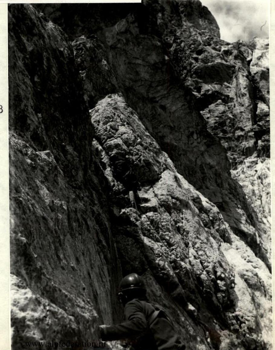
It is an alternation of small walls and shelves. Many ledges. Achasov went ahead.
Section R3–R4
Here Titkin went first and, using aid climbing, passed the section, skillfully working under the cornice, bypassed it by traversing to the slab. Backpacks were hauled.
Section R4–R5
Approach to the inclined shelf, where the group arranged a sitting bivouac.
Section R5–R6
On July 6, Titkin went first. Slowly, reliably passed steep slabs with a small number of holds and reached a simpler section. Piton belay.
Section R6–R7
A fairly simple section.
Section R7–R8
The same. But many loose rocks on the slabs. We went carefully.
Section R8–R9
The inclined shelf under the steep rocks allowed us to rise higher, from where, by traversing, it was easier to reach the steep rocks of the ridge.
Section R9–R10
A small steep section was easily passed first by Titkin (using spacers and a wide crack). The rest went with backpacks, using jumar.
Section R10–R11
The section is simple, but long and with loose rocks. Between the rocks, snow leads to the saddle of the ridge and to a convenient bivouac-shelf.
Section R11–R12
It is a complex section of the wall, with overhangs. Processed by Achasov, and then Titkin within 3 hours. Used ladders, etrier hanging, pendulum movements. A rope was fixed on the section and left for the next day.
After bad weather on July 8, this section became more complicated, but the group passed it well along the fixed ropes. Backpacks were hauled.
Section R12–R13
Further, there was a simpler section, where the group rested.
Section R13–R14
It represents rocks framing the couloir. Quartz structure. Few cracks. Many inclined and horizontal small stones, on which there was snow, and later, as it warmed up, an ice crust. It was impossible to go in galoshes.
Bregman went first, wearing Vibram soles. The rest went with jumar.
Section R14–R15
Steep wall, loose rocks. Exposure is southern, southeastern. The rocks are drier. Titkin went first.
Section R15–R16
The section leads to the summit tower, where a complex wall with cracks is visible. The group stopped and began to organize a bivouac. Titkin continued to process section R15–R16 and the next one.
Section R16–R17
The section was processed on July 8. For 3 hours, it was not possible to fully process it — it was getting dark. The group settled down for the night. The bivouac was sitting. On July 9, the section was passed with jumar. Backpacks were hauled.
Section R17–R18
It represents scree shelves, movement is simultaneous and alternating.
Section R18–R19
Snow slope with ice under a layer of snow, rock outcrops. Not very steep, but dangerous. In general, this is already a ridge leading to the upper point of the counterfort. Simultaneous movement.
Section R19–R20
Ridge of peak Zamok. Simultaneous movement. Thunderstorm, snowfall, limited visibility.
Section R20–R21
Descent from peak Zamok along scree and snow fields.
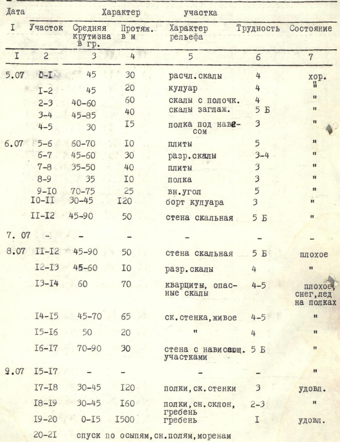
TABLE OF MAIN CHARACTERISTICS OF THE ROUTE on peak Zamok via the E counterfort of the NNE wall, approximately 5B category of difficulty:
— Height difference — 1000 m — Average steepness — 65–70°

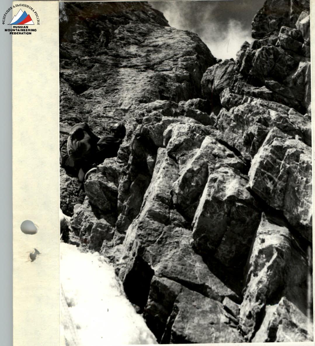
SECTION R0–R1. START OF THE ROUTE.
SECTION R6–R7. ACHASOV AND GORYUNOV AHEAD.
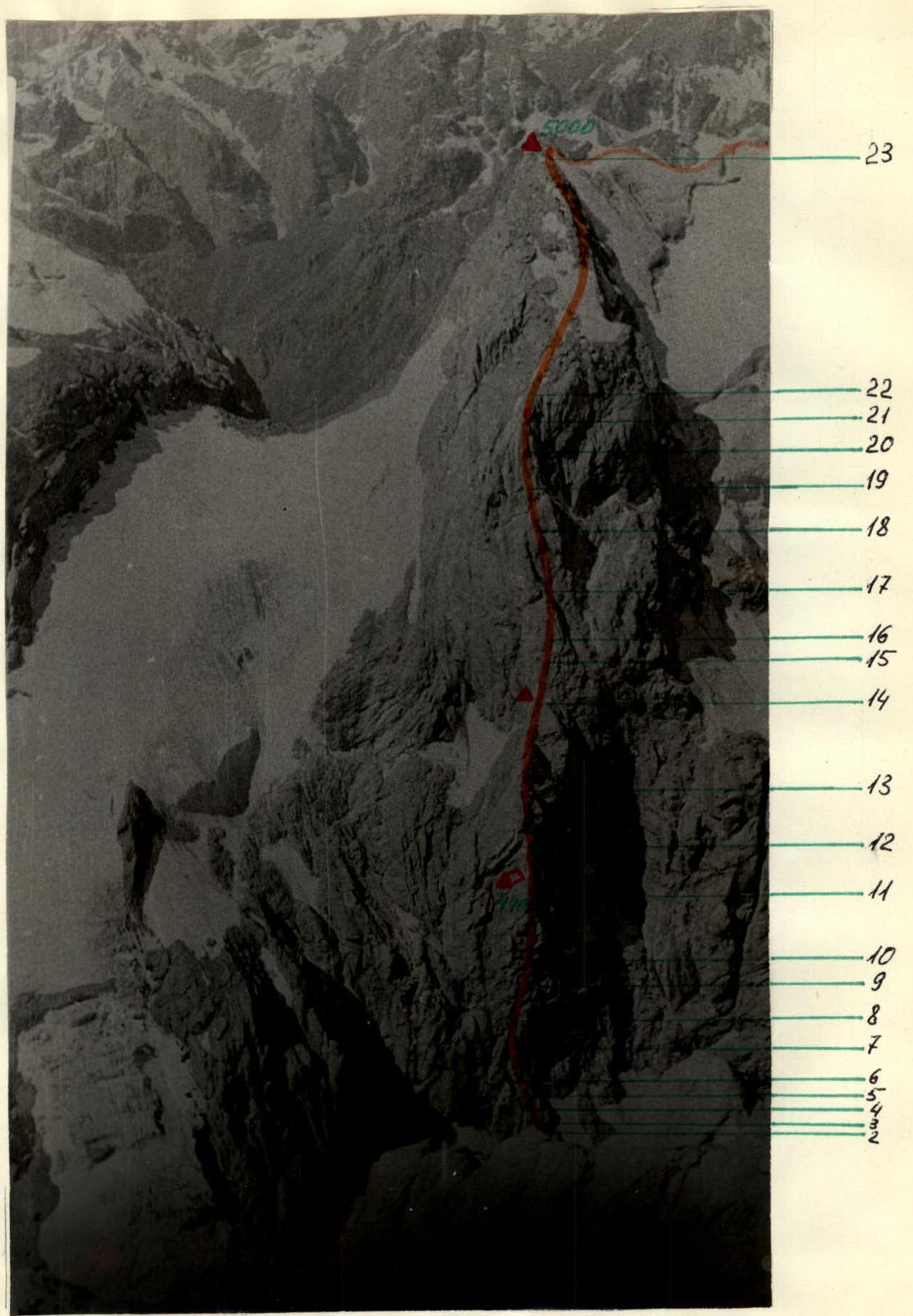
General view of the route.
TABLE OF MAIN CHARACTERISTICS OF THE ROUTE
on peak Zamok via the E counterfort of the NNE wall, approximately 5B category of difficulty height difference — 1000 m, average steepness — 65–70°
| Date | Character of the section | Difficulty | Condition |
|---|---|---|---|
| Section | Average steepness, ° | Length, m | |
| 5.07 | R0–R1 | 45 | 30 |
| R1–R2 | 45 | 20 | |
| R2–R3 | 40–60 | 60 | |
| R3–R4 | 45–85 | 40 | |
| R4–R5 | 30 | 15 | |
| 6.07 | R5–R6 | 60–70 | 10 |
| R6–R7 | 45–60 | 30 | |
| R7–R8 | 35–50 | 40 | |
| R8–R9 | 35 | 10 | |
| R9–R10 | 70–75 | 25 | |
| R10–R11 | 30–45 | 120 | |
| R11–R12 | 45–90 | 50 | |
| 7.07 | |||
| 8.07 | R11–R12 | 45–90 | 50 |
| R12–R13 | 45–60 | 10 | |
| R13–R14 | 60 | 70 | |
| R14–R15 | 45–70 | 65 | |
| R15–R16 | 50 | 20 | |
| R16–R17 | 70–90 | 30 | |
| 9.07 | R15–R17 | ||
| R17–R18 | 30–45 | 120 | |
| R18–R19 | 30–45 | 160 | |
| R19–R20 | 0–15 | 1500 | |
| R20–R21 |
APPENDIX 2
| Section | Weather conditions | Method of movement | Rock pitons | Ice pitons | Bolt pitons | Start time | Stop time | Climbing hours | Overnight stay |
|---|---|---|---|---|---|---|---|---|---|
| R0–R1 | good | alternating, with piton belay | 3 | — | — | 11:00 | |||
| R1–R2 | 4 | — | — | ||||||
| R2–R3 | 5 | — | — | ||||||
| R3–R4 | piton belay, aid climbing, rope hauling | 15 | — | — | |||||
| R4–R5 | piton belay | 4 | — | 1 | 9:00 | 20:00 | 9 | Sitting | |
| R5–R6 | 4 | — | — | ||||||
| R6–R7 | 5 | — | — | ||||||
| R7–R8 | 2 | — | — | ||||||
| R8–R9 | 1 | — | — | ||||||
| R9–R10 | 8 | — | — | ||||||
| R10–R11 | alternating, with piton belay | 10 | — | — | |||||
| R11–R12 | processing, ladders | 18 | — | — | 18:00 | 9 | Good | ||
| R11–R12 | very bad | group did not move | — | — | — | Satisfactory | |||
| R11–R12 | satisfactory | along processed ropes, rope hauling, alternating | — | — | — | 9:00 | |||
| R12–R13 | alternating | 3 | — | — | |||||
| R13–R14 | along perils, piton belay | 10 | — | — | |||||
| R14–R15 | 8 | — | — | ||||||
| R15–R16 | processing, aid climbing | 5 | — | — | 30 | ||||
| R16–R17 | processing, aid climbing | 15 | — | — | 20 | 11 | Satisfactory | ||
| R15–R17 | perils, rope hauling, jumar | — | — | — | 10:00 | 30 | |||
| R17–R18 | alternating, with piton belay and simultaneous | 6 | — | — | |||||
| R18–R19 | — | — | — | reached summit 16:00 | |||||
| R19–R20 | bad | simultaneous | — | — | — | 3.1900 | 9 | ||
| R20–R21 | descent along scree to the lakes | — | — | — |
Comments
Sign in to leave a comment