Ascent Passport
I. Sports organization: Kazakh Climbers' Club. 2. Ascent category: high-altitude, technically challenging. 3. Assault leader: Venckovskiy Gennadiy Zdislavovich.
1st sports category — 31 years old.
- Participants: Akchurin, Marat Khasanovich, 1st sports category; Vereshchagin, Sergey Igorevich, 1st sports category; Il'inskiy, Aleksandr Fedorovich — 1st sports category.
- Peak name, height: p. Zamok, 5070 m.
- Geographic area: Pamiro-Alay, Fan Mountains.
- Route: NW edge, rock.
- Route height: 1445 m.
Wall section height difference — 910 m, including:
- most challenging sections — 270 m.
- Category difficulty rating: 5B.
- Route length: 2620 m.
Including wall section — 1000 m. 11. Route completed August 12–16, 1968. 12. Number of days — 4. 13. Number of bivouacs on the route — 2. 14. Total travel hours: ascent — 33 h, descent — 3 h. 15. Tactics: movement in two teams in organic interaction, first team without backpacks. 16. Technique: during ascent, 77 pitons hammered, during descent — none. 17. Average route slope: 35°, wall section — 65°; including: most challenging sections — 85°.
Ascent Tactics
Start working on the route as early as possible and travel the entire daylight period if the weather permits.
Maintain a high speed of movement. The first climber carries only personal items in their backpack.
The most challenging sections are traversed without backpacks, with the organization of belays; backpacks are pulled up.
Maximum relief for the group: most caloric, light food; special equipment made of titanium.
The route slope is significant; suitable areas for setting up a "Pamirka" tent may not be available, so we proceed with "Zdarki" tents.
Cooking hot meals twice a day, in the morning and evening (at night stops).
Route Description
After completing preparations, the following assault schedule was approved:
August 10–11 — reconnaissance and observation of the route; August 12 — approach to the route and processing; August 13–15 — ascent along the NW edge and descent via the 3B category difficulty route. Expected return to the base camp — August 16.
Departed from the base camp at 7:00. After three hours, we reached the moraine under the white "nose" of the NW edge.
After a short rest — tea break — two climbers without backpacks, carrying both ropes and necessary equipment, proceeded to process the route, while the other team remained to set up a night stop and prepare lunch.
At 11:00, Venckovskiy and Akchurin began processing. We moved up and to the right along a narrow, steep snow ridge, and then along scree to the right of the white "nose," towards the location where the rock belt is narrowest, leading to a scree shelf. The landmark is a noticeable niche at the shelf level. The elevation gain is approximately 250–300 m.
The path is not complicated but somewhat tiring, especially on the fine, steep scree. This is the beginning of the route. We rope up.
Section R1
The rocks are not complicated, with good hand and footholds, but climbing is unpleasant due to many loose stones. We move slightly to the right. The rocks have many characteristic white spots from falling stones. It is necessary to quickly move under the wall and continue under its cover (wall slope 75–80°).
Section R2
Along a wide scree shelf under a steep, partially overhanging wall with small waterfalls, 300 m to the left and upwards towards the shoulder of the yellow "nose" (see photo 4).
Section R3
Exit to the "shoulder" via easy rocks. The route continues along a fairly steep wall. The "nose" shoulder allows us to move 50 m away and photograph the lower part of the wall (see photo 5).
Here, at the base of the wall, we leave the 1st control cairn.
Section R4
Here and further, almost the entire second day, we "take the stone technique exam." The chimneys vary — wide and narrow, straight and winding; sometimes they "invite" inside, sometimes they "push out" onto the wall. Almost all are steep, with jams. Climbing is greatly hindered by backpacks, but organizing a pull-up is rare.
Slightly to the left and below the shoulder — into a chimney; 15 m upwards using holds; the chimney turns into an internal corner — 5 m along the right wall (see photo 6), and then back into a chimney; climbing is complex. We move straight upwards. The rocks are heavily destroyed, rotten; pitons do not hold. Clouds have appeared. There is ice in the chimney. After three meters, we have to exit onto a steep (75°) left wall due to the ice. Here, we finally manage to hammer a 12-mm titanium rod reliably. Another one is at the end of the rope. It's already 15:00. We're hungry. It has gotten significantly colder.
Clouds, "white flies" are flying around. We leave one rope as a belay and descend with the second rope to the night stop. They are already waiting for us with excellent platforms (under "Zdarki") and a delicious dinner.
Early rise, breakfast. We begin movement at 6:00. After 2.5 hours, we're on the shoulder under the wall. The rocks are cold; fortunately, we've warmed up considerably while climbing the scree. We quickly pass the processed section and continue. We were worried about the weather last night, but today is clear, not a cloud, although it's cool — the sun won't be with us until around 2 pm. The only thing that spoils our mood is the abundance of "live" stones since we're climbing almost straight up and need to be very careful not to knock a stone down on the climber below.
Section R5
5 m upwards along a relatively "good" wall — although it's steep (75°), there are convenient holds. But further, the wall starts to overhang; we move right into a chimney (see photo 7). Along destroyed rocks, 35 m, 2 pitons, almost everything is covered in ice. We manage to hammer only one piton (rod). Climbing is done using holds, chipping away ice under the points of support with a hammer. Often, we have to wipe the soles of our boots on our socks or pants. By the end of the chimney, it becomes deeper and narrower, hindered by the backpack. But to the right, there's a ledge 4 × 8 m with a large stone on it, through which we organize belays. We can rest calmly without worrying about knocking a stone down on those below.
Section R6
Further, without backpacks, along a very complex, steep (85°) wall, 10 m to the right and upwards towards the next chimney (see photo 8) (no place to hammer a piton). The chimney is peculiar — narrow, winding. Climbing is very challenging; 25 m is traversed "like a snake." Here, a jam of several large stones overhangs; under it, there's a gap for a leaf-shaped piton. To the right of the jam, 4 m along a sheer wall — into a niche with snow at the bottom, formed by the jam and the chimney's expansion. Belays. Backpacks are pulled up.
The chimney is too narrow here; from above, another jam overhangs, making it impossible to exit. Organizing belay through a piton, we exit onto a very complex, smooth wall to the right (see photo 9). After 15 meters (4 pitons), we enter a chimney — it has narrowed sufficiently. Here, to the piton, we pull up the backpacks — it's impossible to push them further.
The chimney is vertical, with smooth walls; climbing is done using holds and friction. After 5 m, the chimney starts to widen, "inviting" us to enter, but after another 10 m, it narrows quite sharply, making it very difficult to exit back down the chimney walls with holds. This is the first key point of the route.
The rock is monolithic; there's nowhere to hammer a piton. After another 20 m of very challenging climbing in a narrow chimney, we exit onto a steep (45°) ledge on the right wall of the chimney with a good step; opposite the ledge, there's a wide gap (about 20 mm) for a U-shaped titanium piton. From above, 8 m away, a jam of huge stones overhangs. Exiting the chimney onto the wall is impossible without bolt pitons, but the group decided to complete the ascent without using them.
We exit under the jam. Between the stones, a narrow passage is found. We manage to climb through it with difficulty. The backpacks can't be pushed through; we pull them up along the wall.
We're on an uneven, horizontal ledge 1 × 6 m — for the first time in this day, we're in the sun. We sit for 20 minutes, enjoying the warmth, having a small snack. We assess the further route. Above us is a vertical, very smooth, monolithic wall, seemingly made of granite. To the left — completely hopeless slabs; to the right — a "guardian" slab detachment.
Section R7
Along a narrowing ledge to the right and downwards, 5 m towards the "guardian" slab detachment. Using holds, 5 m upwards, and then a transition to the wall (see photo 10). A piton (rod) is hammered, and here we have to leave the backpack. Further, 35 m of very challenging climbing to the right and upwards. We manage to hammer only 2 pitons. The wall leads to a small ledge — an internal corner overhanging on the left side. There's also a large protrusion, convenient for organizing belays. We pull up the backpacks.
Section R8
Along the internal corner at 75°, and then to the right of the cornice along a steep (85°) wall, we climb upwards 30 m. There are cracks for pitons. Climbing is quite challenging, but after the granite wall, we feel confident. The wall leads to a small ledge (see photo 11) 6 m below an overhanging cornice by 30 cm. The cornice is climbed directly, there's a place to hammer a piton. Behind the cornice is an uneven platform with steps for organizing belays.
Along medium-difficulty rocks at 55°, we traverse 5 m to the left around a bend, and then 20 m upwards. To the right, under a 10-meter vertical wall — a decent platform. Slightly below, in a deep crack, there's ice. Above, very smooth, steep slabs are visible. Clouds have appeared. We've covered a lot, and we're already quite tired. It's 17:00. We decide to set up a night stop (see photo 12), and the other team immediately goes up to process the visible challenging section.
Section R9
Along easy, then medium rocks, we exit onto a ledge 1 × 8 m under a vertical wall. These are smooth, monolithic slabs; in the lower part, there's a half-meter overhang. The path to the left is impassable — on the vertical wall, ice has formed. We attempt to bypass the slabs to the right. We exit to a sheer, very destroyed internal corner. Holds come off in our hands; everything is unreliable. There's nowhere to hammer a piton. We need to cover more than 20 m. It's not safe to climb here.
Only one option remains. In the center of the wall, a fairly thick slab, having detached, formed a narrow vertical gap — just enough to squeeze through with our bodies (see photo 13).
Section R10
Here begins the second key section. Directly into the ledge, a titanium rod is hammered. Movement is vertical, upwards, through the overhang by 0.5 m. After traversing 4 m, we enter a crack under the detached slab. Both slabs are very smooth, monolithic. There's nowhere to hammer pitons, and it's physically impossible due to the narrow and shallow crack; all movements are very constrained; a hand or foot can be lifted off the rock only for a few seconds to find a new hold. Climbing is done almost without holds, using friction, and the friction is very weak, even in boots! 5 m along a slightly overhanging edge of the detached slab, there's a step; we can rest. Above, the crack widens slightly. From above, a jam overhangs; under it, there's a wide crack for a channel-shaped piton. Using the piton as an artificial hold, we exit onto the jam. Here, there are excellent cracks. On two rods, we hang belays. It's already 19:00. The first ascent of this section took more than 1 hour.
We descend along the hung ropes to the night stop location. It's not very comfortable but safe — protected by a vertical wall from possible falling stones; there are cracks to organize self-belay through pitons; there's ice. Low clouds are moving across the sky; it's lightly snowing "sleet"; a gusty wind is blowing; the setting sun occasionally appears.
The outcome of the second day: we've passed the steepest and, apparently, the most challenging part of the wall. It's very good that we started early — we managed to reach a relatively acceptable night stop location and will be able to rest well. Climbing cold morning rocks is difficult, but waiting until mid-day when the sun appears is impossible, and the weather might deteriorate further. We'll rise early in the morning. We set up the second control cairn.
August 14, 1960, 6:00. Cold, clear, but we're no longer sure about the weather. We gather, have breakfast, and at 7:00, the first team begins movement. The passage of the processed crack yesterday is met with lively "comments." Now the backpacks are pulled up (see photo 14); the last climber begins the ascent; we move further.
Section R11
Along a narrow, horizontal ledge, 5 m to the left, bypassing a 15-meter vertical wall, and we enter a wide, ice-filled couloir with a slope of 55°. The left, far bank is an overhanging wall; the right, "our" bank, consists of very smooth slabs with a slope of 50°. Along these slabs, hammering titanium rods every 8 m, we climb 30 m upwards. Here, the couloir is dry. Through a large step, we organize belays. We've reached the overhanging 50-meter rocks, which are impossible to climb.
The only possible path is 6 m below, in the couloir, through a small gap in the "balcony" (again a chimney), through which water enters the couloir. Below this gap, in the wall at 85°, there's a crack along which we need to find a path. Fortunately, the water has receded (but, as it turned out later, not entirely) along the wall, forming a very beautiful garland of many small icicles. It's already thawing; the ice waterfall is very beautiful but evokes far from benevolent feelings — we'll have to climb right through it in the upper part. But the crack looks promising from afar.
Section R12
Along a wall overhanging by 0.6 m, 4 meters to the crack. However, upon closer inspection, it's far from as attractive as it seemed from afar.
Its inner walls are smooth; there are no holds either in it or on the wall. The cracks are overgrown, and pitons "won't go in." The main issue is that the wall above is shiny — a thin layer of ice! It becomes clear that further movement upwards will require maximum tension of all forces. This section is only suitable for a very strong, mentally stable rock climber. Upon exiting to the crack, a piton is hammered, and the backpack is left on it (see photo 15).
Further, about 12 m is traversed without piton belay, relying solely on technique. The right hand and foot are wedged into the crack. For the left hand, we need to find "footing" that isn't icy; then the same is used for the left foot. It's not possible to chip away the ice — the rocks have a typical "Fan" rough structure. 1.5 m from the chimney, we manage to hammer a leaf-shaped piton and take a break.
Further climbing is simply very challenging: a vertical, wide, ice-filled, wet chimney (see photo 16). We exit onto the entire rope's length (the belayer has to move under the wall). Here, there's a large 3 × 4 m ledge, two pitons, belays, and the backpacks are pulled up. This is the third key section, the most challenging on the route. It's traversed almost without piton belay, relying on refined rock technique and high moral and physical preparation. Here, we leave the third control cairn.
The weather has already deteriorated. Low clouds, sleet, wind, cold.
Section R13
Further, 170 m of simple and medium rocks at 50–60° to the right of the ridge. Here, the NW edge converges with the higher NNW edge. Slightly to the right, the pre-summit is visible. It's separated from the NNW edge and its southern steep walls by a deep, steep, stepped couloir; the approach to it is very complex in the lower part. We need to climb the wall to the upper part of the ridge and find a path to the pre-summit there.
Section R14
The section is a 95-meter wall interrupted by two ledges, approximately every 30 m.
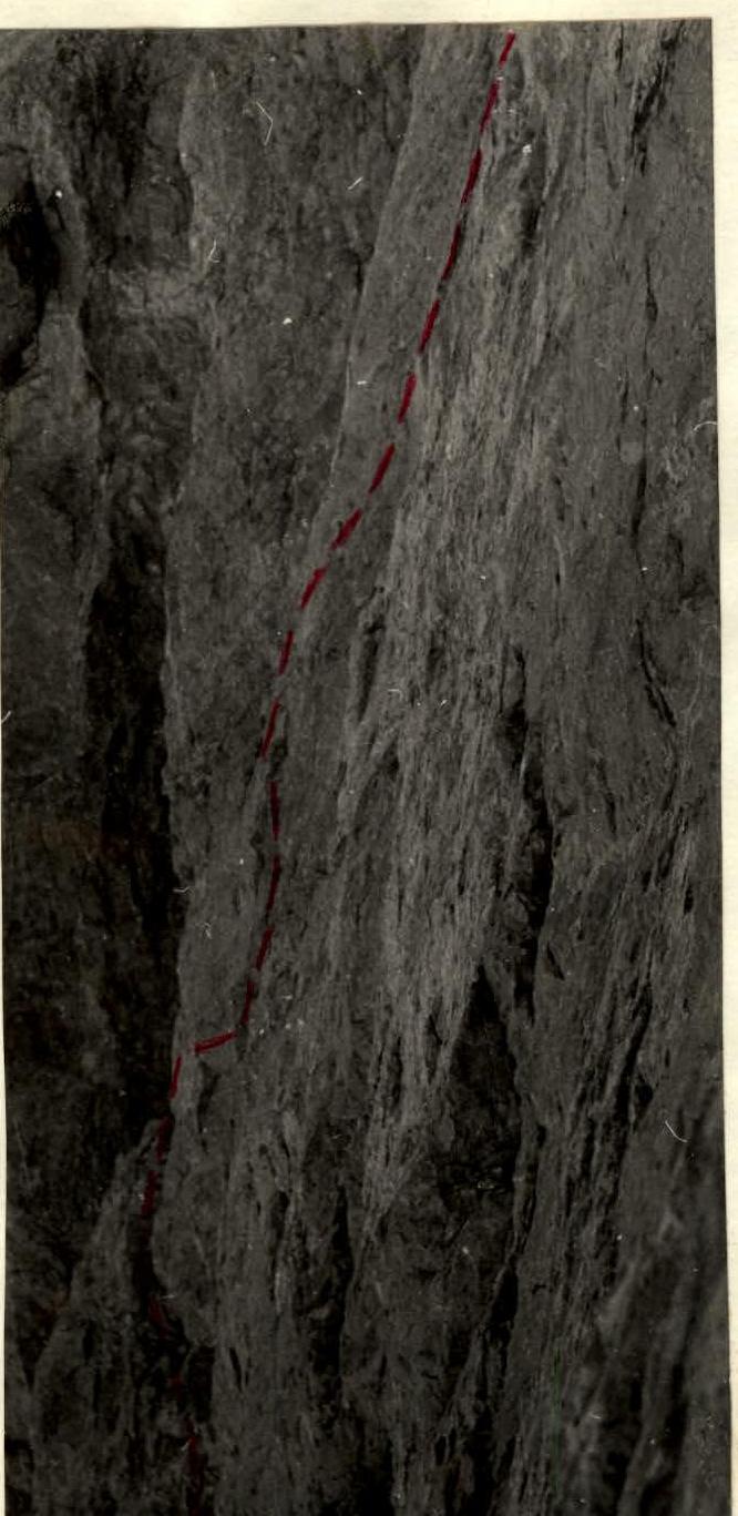
Photo 17. The third part of the wall. Section R14. p. Zamok.
The first third consists of rocks of medium difficulty, with a slope of 75°. The second and third parts are significantly steeper — up to 80° (see photo 17). Climbing is complex. There are cracks for pitons. 8 m after the first ledge — very challenging (see photo 18). The wall leads to a platform under the "fingers" of the NNW edge with a good protrusion for organizing belays. It's 17:00. We're tired; a very challenging section is visible ahead. The platform is quite suitable for a night stop.
The chimneys between the "fingers" are entirely filled with ice. Many ice waterfalls and large icicles, but a huge "finger," 12 meters in diameter, reliably protects the platform. Again, one team goes up to hang ropes, while the others set up a bivouac and prepare a hot meal.
Section R15
To the "finger," to the right of the platform, a comparatively small protrusion adjoins, made of a different rock type ("fingers" are made of pink granite, monolithic, very smooth; the protrusion is dark, destroyed). It's cut by a vertical couloir filled with ice. The "protrusion" overhangs more strongly on the right; on the left, it's less pronounced (by 0.7 m).
In the chimney between the protrusion and the "finger," there's an ice waterfall. We climb upwards along the left, narrower part of the protrusion (see photo 19), using pitons as artificial holds. The rock surface is fairly even, but deep in the left chimney, by chipping away icicles and ice, we manage to find good holds. Climbing is very challenging. This is the fourth key section of the route. It requires significant physical strength, endurance, and excellent coordination, despite its relatively short length (15 m). We hang belays.
We assess the further route. The visible part is clearly simpler than what we've traversed. Tomorrow, we should reach the summit.
We descend to the night stop location. 18:00. An excellent platform for four has already been set up here; everything is well-arranged (see photo 20). We sit down to dinner-supper. Unexpectedly, the sun appears through a gap in the clouds; it immediately warms up, and... literally within a few seconds, icicles, ice fragments, and ice pieces start falling with a characteristic "glassy" sound and clatter on both sides of the platform! We processed this section just in time!
The fourth day: ascent, breakfast; we leave the 4th control point at the night stop; at 8:00, we begin movement. We traverse the belays, pull up the backpacks. Clear, cold, we're in the shade.
Section R16
Along несложным полкам under the "fingers," we traverse 40 m towards the pre-summit. The slope is 45°.
Section R17
A complex 35-meter wall (80°) leads into the upper part of the couloir at the pre-summit — it was visible from section R13. We pull up the backpacks.
Section R18
Along a несложному wide couloir at 55°, filled with stones, we climb 30 m directly to the pre-summit. We need to be аккуратными and hammer pitons — there are many "live" stones. The pre-summit overhangs us. The path is the only one.
Section R19
Along a steep, very complex, smooth wall, using a piton as an artificial hold, we exit 6 m onto a ledge under a steeply overhanging chimney. The chimney is deep, narrowing towards the top. There are almost no good ledges or holds; climbing is done using friction. There are good cracks for pitons. The location is psychologically challenging — the narrowing chimney "squeezes" you towards the edge, and you find yourself first above your companions (the chimney overhangs), and then "behind" them! Climbing is very challenging. We pull up the backpacks.
Section R20
Along rocks of medium difficulty, 120 m, we traverse to the right, bypassing the pre-summit. The average slope is 45°. Belay is through ledges. A 10-meter wall with a slope of 60° leads to the pre-summit. And at 12:00, we're finally on the sunlit pre-summit. Before us lies the gentle dome of the summit. We change clothes, set up the last, 5th control cairn.
Section R21
Along a gentle firn, and then scree dome, at 13:00, we reach the summit. We retrieve a note left in 1966 by a group of climbers from the GDR who ascended p. Zamok via a route previously classified as 3B category difficulty.
Section R22
Through a black scree "guardian," we descend to the east, and then to the south towards the glacier (route 3B). We hear a shout — we're spotted by a group led by S. Bergman, completing a first ascent of p. Bodhana. We respond and continue downwards. At 16:00, we're back at the first night stop on the moraine under the NW edge of Zamok.
Conclusion
The group members, having experience in ascents via various routes in Tian-Shan, Pamir, Caucasus, and Pamiro-Alay, consider the traversed route along the NW edge of p. Zamok to meet the requirements of 5B category difficulty.
Table
The main technical characteristics of the ascent route along the NW edge of p. Zamok 5070 m. Height difference (maximum) — 1445 m. Height difference of the rock section — 910 m, with an average slope of 65°; of these, the highest difficulty section — 270 m, with an average slope of 85°.
| Date | Section № | Elevation gain, m | Length, m | Average slope, ° | Brief terrain characteristic | Technical difficulty | Belay method | Weather conditions | Departure time | Stop time | Travel hours | Pitons hammered | Rock, m | Ice, m | Backpack pull-up | Night stop conditions | Daily ration weight, g |
|---|---|---|---|---|---|---|---|---|---|---|---|---|---|---|---|---|---|
| August 12 | R1 | 10 | 15 | 45–50 | Wall of the rock belt separating scree from a wide ledge leading to the ridge. | Easy | Good | 11:00 | 15:00 | 4 | 300 | ||||||
| ... | ... | ... | ... | ... | ... | ... | ... | ... | ... | ... | ... | ... | ... | ... | ... | ... | ... |
| Total 1st day | 330 | 600 | 4 | ||||||||||||||
| August 13 | R5 | 55 | 60 | 60–65 | Passage of sections R1–R4. Medium rocks. Chimney with ice; complex wall. | Medium difficulty | Ledges | Good | 6:00 | 19:00 | 13 | 4 | 4 | 700 | |||
| ... | ... | ... | ... | ... | ... | ... | ... | ... | ... | ... | ... | ... | ... | ... | ... | ... | ... |
| Total 2nd day | 330 | 340 | 75 | 28 | 95 | ||||||||||||
| August 14 | R11 | 30 | 35 | 55 | Very smooth slabs on the right bank of a wide, ice-filled couloir. | Challenging | Ledges, pitons | Good | 4 | 700 | |||||||
| ... | ... | ... | ... | ... | ... | ... | ... | ... | ... | ... | ... | ... | ... | ... | ... | ... | ... |
| Total 3rd day | 320 | 355 | 65 | 30 | 75 | ||||||||||||
| August 15 | R16 | 30 | 40 | 45 | Easy ledges under the "fingers" of the ridge. | Easy | Ledges | Good | |||||||||
| ... | ... | ... | ... | ... | ... | ... | ... | ... | ... | ... | ... | ... | ... | ... | ... | ... | ... |
| Total 4th day | 480 | 1265 | 20 | 14 | 70 |