Ascents
-
Ascent class: Technical ascent class.
-
Ascent area, peak:
Zeravshan Range, Fann Mountains (53)
-
Peak, its height, ascent route:
Zamok peak, height 5070 m, ascent route via the West face
-
Estimated difficulty category: 5A
-
Route characteristics:
- height difference
- length of sections 5–6
- average steepness
height difference: 5070–4420 = 650 m. Length of sections 5–6: 300–350 m. Average steepness 50–55°.
-
Pitons driven:
- for belaying, for creating, etc.;
- rock — 66+1,
- ice — 4,
- bolt — —
-
Number of travel hours: 14 h
-
Number of nights and their characteristics:
1 overnight stay, good.
-
Surname, name, patronymic of the leader, participants and their qualifications:
Ilyin Vladimir Leonidovich — 1st sports category Dronov Yuri Stepanovich — 1st sports category Efimov Valery Emelyanovich — 1st sports category Malamid Vladimir Mendelevich — 1st sports category
-
Team coach: USSR Master of Sports Arefieva Rufina Grigorievna
-
Date of departure and return:
22–23 August 1978
Brief description of the route
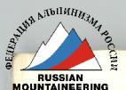
(explanatory note to Appendix No. 1) The route starts along the left (in the direction of travel) edge of the scree descending from under the middle of the West face of Zamok peak. Climb 80 m up the slab along the edge of the scree (R0–R1) (scree is loose) and then turn left-upwards along the "lby" 80–100 m to the shoulder of the West ridge (R1–R2). Control cairn No. 1. Then continue straight up the ridge for 180 m (R2–R6). Climbing is difficult, in some places (R4–R5) very difficult. Exit to a scree shoulder, here is control cairn No. 2. A bivouac is possible, there is no water. From the start of the route 6–7 hours.
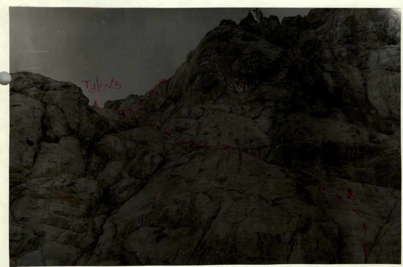
From the cairn straight up 75–80 m under the "shcherbataia" rock (R6–R8) and 30 m below it - traverse left along the slab 70 m, bypassing the rock, and then left-upwards to the shoulder (R8–R9). Here is control cairn No. 3.
To the left is a wall separating our route from the NW ridge, along which the Ventskovsky route passes. From the cairn up along the ridge, composed of "baranii lby", 35 m of difficult climbing (R9–R10).
Further:
- right-upwards, bypassing the "lby" 40 m (R10–R11);
- then up along the "lby" 80 m under the base of the bifurcated tooth on the pre-summit ridge (R11–R12).
Under the tooth - traverse left 40 m along the scree ledge (R12–R13), leading to a scree shoulder. Here the group organized an overnight stay (there is water (ice)). From control cairn No. 2 - 5–6 hours.
From the overnight stay 40–50 m left, bypassing the tooth along the scree, turning into a rock ledge, crossing a couloir with flow ice, and then up along the destroyed ridge (R13–R14) under the wall of the trapezoidal tower on the pre-summit ridge, located to the left of the bifurcated tooth. Up the wall 12 m of difficult climbing (R14–R15) to a rock mulde in the wall and from there right-upwards along the gully-corner 40 m (R15–R16), which leads to the ridge of the tower.
Further along the destroyed rocks 50 m up (R16–R17) to the left of the inner corner, filled with ice. Exit to the pre-summit plateau. Here on the scree a good bivouac with water is possible. From the overnight stay 2–2.5 hours.
Further right-upwards along the ice slope 80–100 m (R17–R18) with an exit to a wide scree ridge and along it 250–300 m to the summit (R18–R19). From the pre-summit plateau 20–30 minutes.
Descent from the summit - via route 1B cat. diff.
Description compiled by Ilyin V. L.

Table of main route characteristics (Appendix No. 1)
Date: 22 August 1978
| Section designation | Average steepness in degrees | Length in meters | Terrain character | Cat./diff. | Condition | Weather conditions | Rock pitons | Ice pitons | Bolt pitons | Notes |
|---|---|---|---|---|---|---|---|---|---|---|
| R0–R1 | 30 | 80 | slab | 2–3 | monolith with rubble | Overcast, variable wind | ||||
| R1–R2 | 30–35 | 80–100 | "lby" | 3–4 | Cold | 5 | Control cairn No. 1 | |||
| R2–R3 | 60–65 | 30 | wall | 3 | destroyed rocks | Wind | 4 | |||
| R3–R4 | 65 | 80 | wall | 5 | monolith | 13 | ||||
| R4–R5 | 80–85 | 10 | inner corner | 5–6 | 2 | 1 | Control cairn No. 2 | |||
| R5–R6 | 60–65 | 60 | slab | 4–5 | 5 | |||||
| R6–R7 | 30–35 | 40 | 3 | Variable cloudiness | 4 | |||||
| R7–R8 | 60 | 35 | 5 | 4 | ||||||
| R8–R9 | 40–50 | 145–150 | 4–5 | 18 | Control cairn No. 3 | |||||
| R9–R10 | 50–55 | 35 | ridge of "lby" | 5 | Sunny, wind | 5 | ||||
| R10–R11 | 35 | 40 | "lby", "baranii" | 2–3 | destroyed rocks | 1 | ||||
| R11–R12 | 40 | 80 | 3–4 | monolith | 4 | |||||
| R12–R13 | 20–25 | 80 | wide ledge | 1–2 | scree and monolith | Variable cloudiness | Overnight stay good. 11–13 h |
Table of main route characteristics (Appendix No. 1)
Date: 23 August 1978
| Section designation | Average steepness in degrees | Length in meters | Terrain character | Cat./diff. | Condition | Weather conditions | Rock pitons | Ice pitons | Bolt pitons | Notes |
|---|---|---|---|---|---|---|---|---|---|---|
| R13–R14 | 25–30 | 20 | ridge | 2–3 | destroyed rocks | Overcast, cold, wind | 2 | 2 | ||
| R14–R15 | 75–80 | 12 | wall | 5 | monolith | 2 | ||||
| R15–R16 | 45 | 40 | gully | 3–4 | destroyed rocks | 3 | ||||
| R16–R17 | 30 | 50 | ridge | 2–3 | Sunny, variable wind | Bivouac possible | ||||
| R17–R18 | 30 | 80–100 | ice slope | 2–3 | sastrugi | |||||
| R18–R19 | 0–5 | 250–300 | ridge | 1 | scree | Zamok peak 5070 m | ||||
| 3–3.5 h |
Appendix No. 3
General characteristics of the route
The route mostly passes along smooth slabs and "lby" with a small number of cracks and holds. The entire route is climbed in galoshes, requiring good friction climbing skills.
The route is objectively completely safe, logical, and beautiful. From the previously climbed routes on this side, Osh and Ventskovsky's routes, our route is separated by walls, so it does not intersect with them anywhere.
Brief description of the approach to the route
The path from Lake Bibi-Djanat goes through the Alaudin pass to the Alaudin lakes (3 h) and then up the gorge along the trail leading to the Mутные lakes. Before reaching the Mутные lakes, turn left and under the slopes of Peak Foggitor climb up the glacier tongue, covered with debris, bypassing the pedestal of Zamok peak on the right. Climb up to the scree above the pedestal and, traversing it left in the middle part, approach the uppermost snow patch on the scree, located under the middle of the West face of Zamok peak (from Alaudin lakes 5 h). Here the team organized an overnight stay. From the overnight stay to the start of the route - 25–30 minutes.
Brief description of the descent
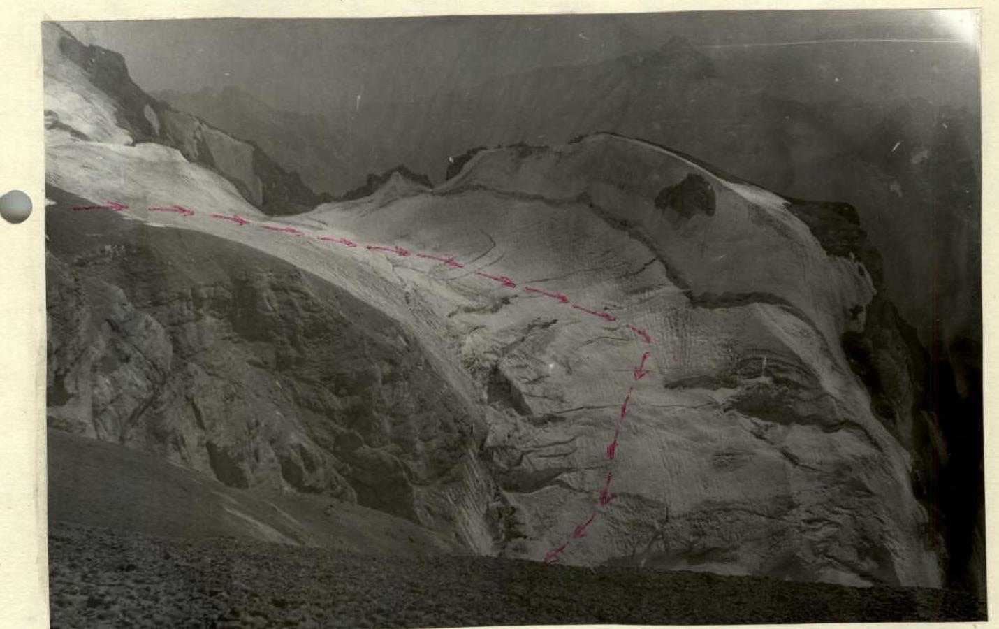
(via route 1B cat. diff.). Descent from the summit is done forward along the ridge, bypassing the red gendarme on the right, and then right along the ridge in the direction of Peak Paykhamber. Exit to the glacier (do not turn right earlier into the scree couloir) and cross it to the right down-left. Cross the bergschrund in the left part of the glacier, descend to the right-down to exit to the gentle part below the icefall. Then to the right onto the scree and down the scree along the West and South faces of Zamok peak to the bivouac. The descent takes 1.5–2 hours.
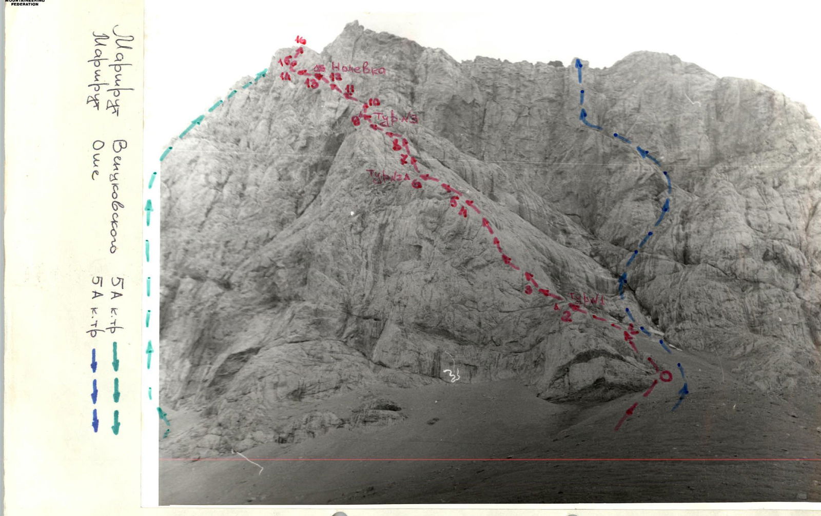
Passing the inner corner. Section (R4–R5)
Descent along the Paykhamber glacier (view from Zamok peak)
View of the route from the southwest (taken from the descent after exiting onto the scree)
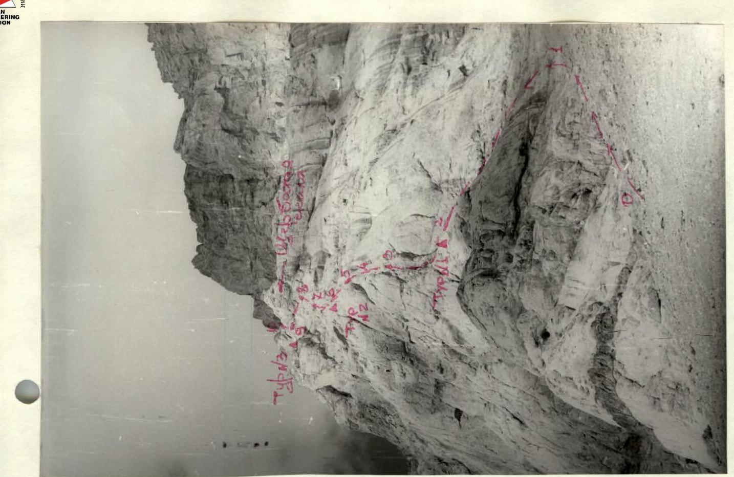
Bypassing the "shcherbataia" rock. Section (R8–R9)