Ascent Passport
- Ascent class — technical
- Ascent area — Pamir-Alay, Fann Mountains
- Peak, its height, ascent route — p. VEI, 4400 m, South-West ridge
- Estimated difficulty category — 3B
- Route characteristics: height difference — 700 m length of sections with 5–6 difficulty category — none average steepness 45°
- Pitons hammered: rock — 15 chocks — 12
- Number of climbing hours — 5.5 hours
- Number of nights — 0
- Surname, name, patronymic of the leader, participants and their qualifications: leader Gudialis Algis Vitautovich — 1st sports category. Simutis Rimutis Rozovich — 1st sports category. Navickas Stanislovas Ivanovich — 1st sports category. Volungyavichyus Gintaras Pranovich — 1st sports category. Virbalis Kestutis Adomo — 1st sports category. Pundzyus Edvardas Vinco — 1st sports category.
- Team coach — Makauskas Dainius Antano, Master of Sports.
- Date of departure and return:
July 25, 1980 – July 25, 1980
Brief description of the area and ascent route
The Fann Mountains, where p. VEI is located, are part of the Pamir-Alay mountain system and are situated between the Gissar and Zeravshan ridges.
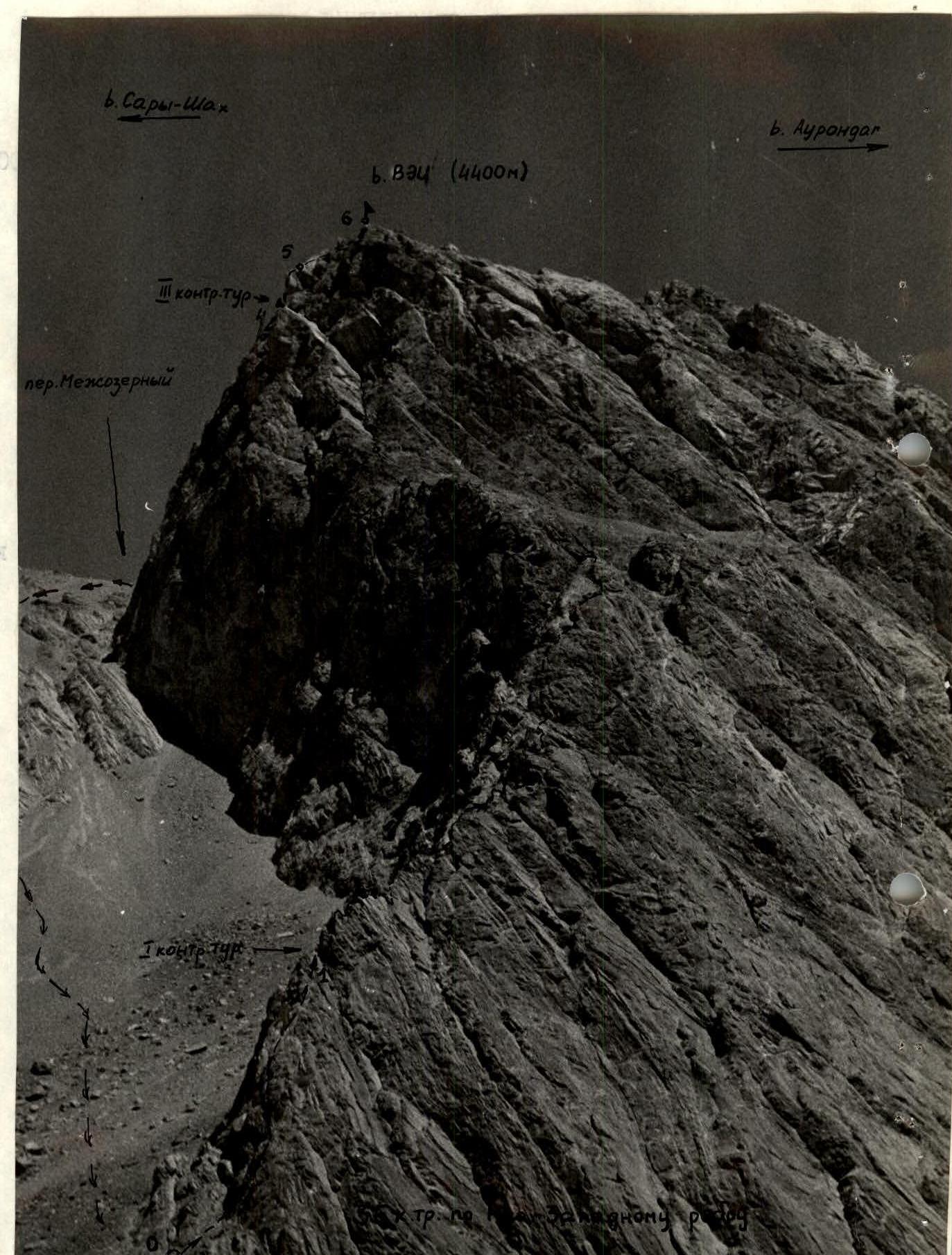
The peak VEI has a height of about 4400 m and is located in the ridge separating the Artuch and Zindon river basins. It is situated between the peaks Sary-Shakh (4650 m) and Aurondach (4573 m). From the north side (Artuch river side), the peak VEI appears as a small rise in the ridge and drops to the north with a black, very crumbly and stone-hazardous wall. From the south side, towards the Zindon river, VEI appears as a clearly defined peak. A rocky ridge extends southwest from the peak. From Lake Bolshoe Allo, the rocky ridge is very clearly visible, and the route along it is logical. The height difference from the beginning of the ridge to the peak is approximately 700 m, with an incline of up to 45° near the pre-summit tower. The pre-summit tower is "separated" from the ridge by a very large scree shelf-log having an incline of about 20°. At the very bottom edge of the pre-summit tower, a wide inner corner leads to the peak, and the route follows this. The inner corner is the key point of the route. Here, sections of 4B category difficulty are encountered, which can be passed by free climbing, without artificial support points, only by well-trained climbers.
It should be noted that the route's logic lies in the fact that, having started from the foot of the ridge, it is impossible to get lost in it. The route is unambiguous, and key points are necessary. Up to R2 control point, the rocks are clean and not stone-hazardous.
In the wide inner corner, stones can be dislodged by rope. The only stone-hazardous section is R4–R5 (above R3 control point). There is no water throughout the route. The route has a long exposure section and is sunlit from early morning to evening until the inner corner.
Compared to other 3B category routes in the Zindon gorge and Artuchya tourist camp, this route is technically more complex than routes on p. Shogun-Aga via NW ridge, Urech via NE wall, Urech via NW ridge, Khorharovat via N ridge, and p. Chaplygin, and its complexity can be compared to the route on p. Moskva from the Northeast.
Brief description of the approach to the route
From the base camp on Lake Bolshoe Allo, follow north towards the Mezhozerny pass, located between the peaks Sary-Shakh and VEI. From the foot of the pass, a clearly defined rocky ridge of p. VEI extends. It takes one hour to walk from the base camp to the start of the route. From Lake Bolshoe Allo, the entire route along the Southwest ridge is clearly visible.
Brief explanation of the table
Section R0–R1. Up steep 45°–50° slabs 40–45 m to the top of the ridge. The ridge is a sharp crest. Slabs are rough, with few cracks, good holds. Pitons used for protection. R1 is a control point.
Section R1–R2. Along the crest 45° 40–42 m to a wall. The wall is 8 m 70°–75°. Pitons used for protection. After the wall, a small dip (10 m). Then 40 m along the sharp crest under a rusty overhanging wall. Under it is a good platform. The wall is bypassed on the right along a monolithic, inclined shelf 15 m. Then 40 m to the base of a 60-meter wall of a gendarme. To the wall, along a scree wide shelf, simultaneously. First, the wall is an 8 m 60° wall (3A–3B category), then along a destroyed groove straight up, to the right, and up again. Climbing is moderately difficult (5B category). Steep. Places up to 80°, but with good holds. Rock texture is rough with very sharp holds. After 35 m, a good platform for protection. Then up along a crack and shelves. Steepness from 45° to 65°. Pitons used for protection (2 pitons). After the wall, 40 m is a simple shelf, simultaneously (1B category) under a 75° 12 m high wall. Climbing is difficult, few cracks (4B category). After the wall, to the gendarme on the left — 20 m, with alternate protection. Then follows a small dip and an exit to the gendarme about 3 m — very difficult (4B category). Then 3 m descent and ascent (3B category) to the second gendarme. Both gendarmes can be bypassed on the right, but the bypass is equivalent in technical difficulty. On the second gendarme is R2 control point.
Section R2–R3. After the control point, 25 m simultaneously along a platform, from which a stone-hazardous scree couloir descends. To the left, along a gentle chimney 10 m. Then to a gendarme 15 m along a 75°–80° wall. Rocks are 4A category. After the wall, a good platform. Then along a shelf on the left to a second wall. General direction is along the crest. Then to the right along a shelf towards a couloir. Should follow the shelf and stay left of the couloir, which is stone-hazardous. Approximately 160 m with alternate protection. Rocks are 2B category. Then begins a scree inclined area. Possible bivouacs. No water.
Section R3–R4. Then follows a wide inner corner, located at the left edge of the crest (tower peak). Initially, rocks in the inner corner are simple 50 m, but then become more complex (3B category) and approach a complex 2.5-meter wall within the inner corner. Passage is difficult (4B category). Then along the inner corner 35 m under a small overhang. Rocks are 4A–4B category. Under the overhang, it is convenient to belay, protected from stones that may be dislodged by a teammate passing the corner above. Then along the rocks of the corner (4B category) 40 m to a rusty smooth wall. Should go left along the wall, along rocks of 3B category, to a small shoulder, where R3 control point is located. The shoulder is visible from afar, from Lake Bolshoe Allo, in the upper part of the summit tower against the sky.
Section R4–R5. From the shoulder, along strongly destroyed and stone-hazardous rocks to the right 40 m to a scree shelf before the summit.
Section R5–R6. Then 200–250 m along scree, bypassing walls, to the summit. Simultaneous movement.
Section R6–R7. Descent from the summit towards Mezhozerny pass along rocks of 2B category about 200 m. This section can be overcome either by free climbing or by sport rappelling on a rope.
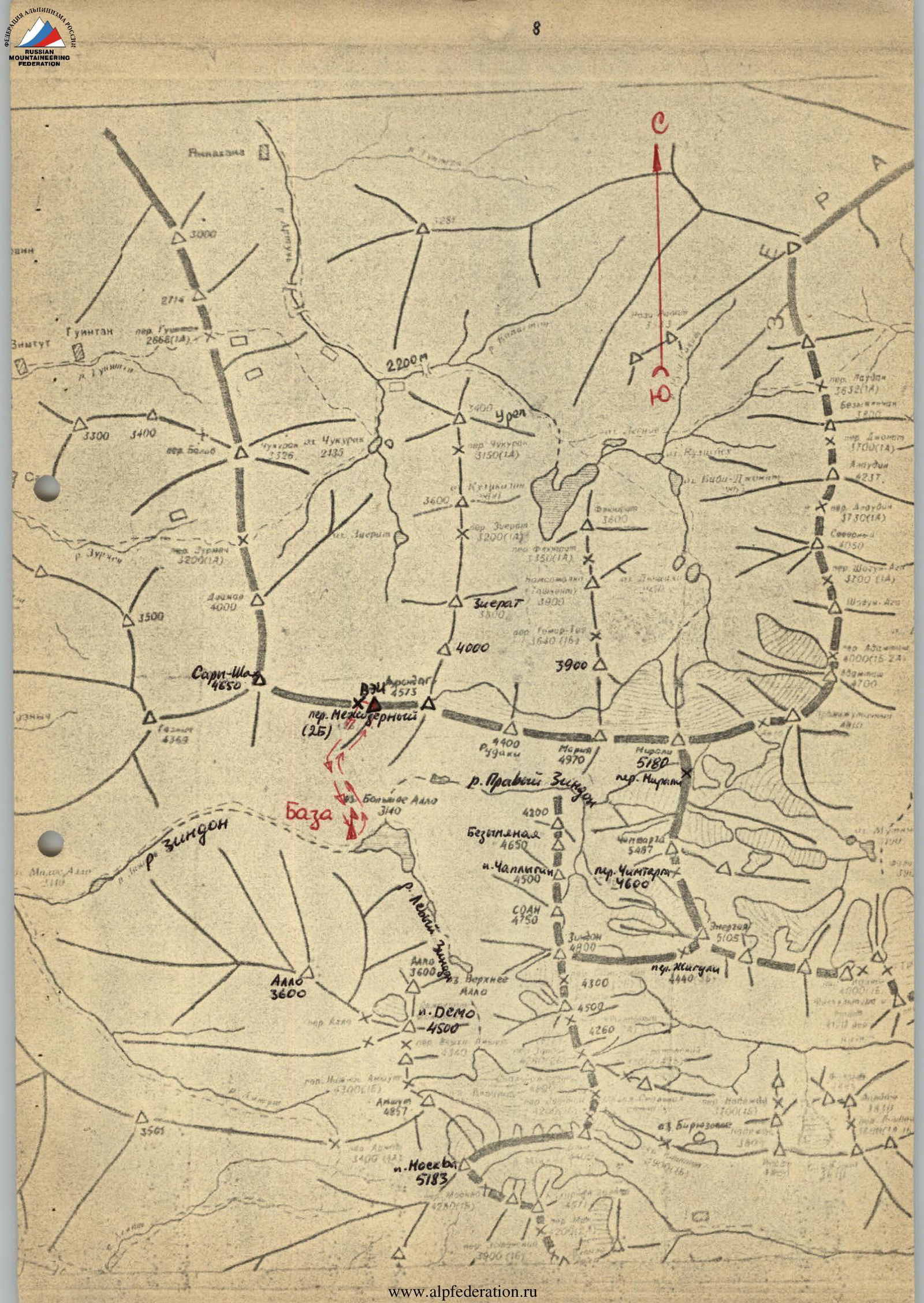

Fig. 3. On the crest of the SW ridge. Section R2–R3.
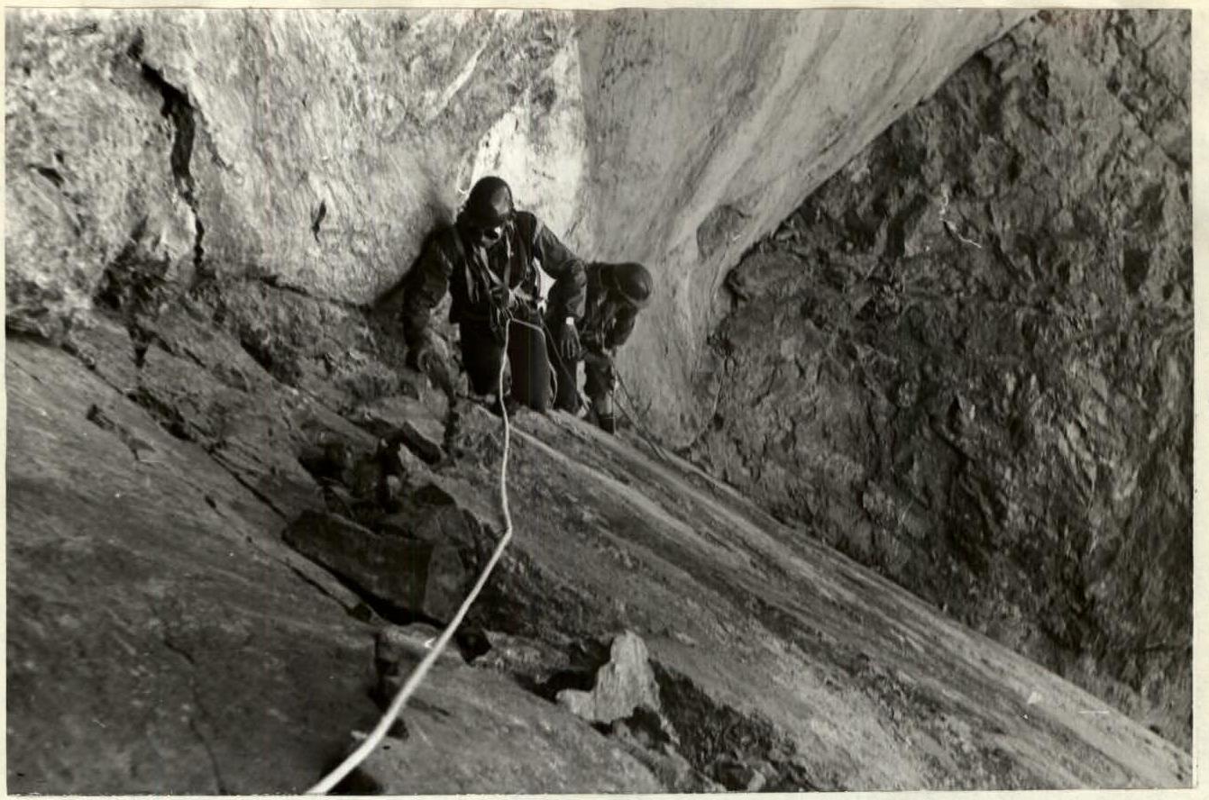
Fig. 7. Moving along the rusty sheer wall to R3 control point. (End of section R3–R4).
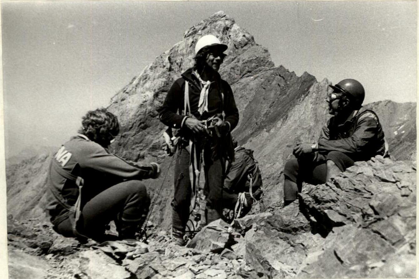
Fig. 8. On the summit of VEI (4400 m). In the distance, Sary-Shakh (4650 m) is visible.

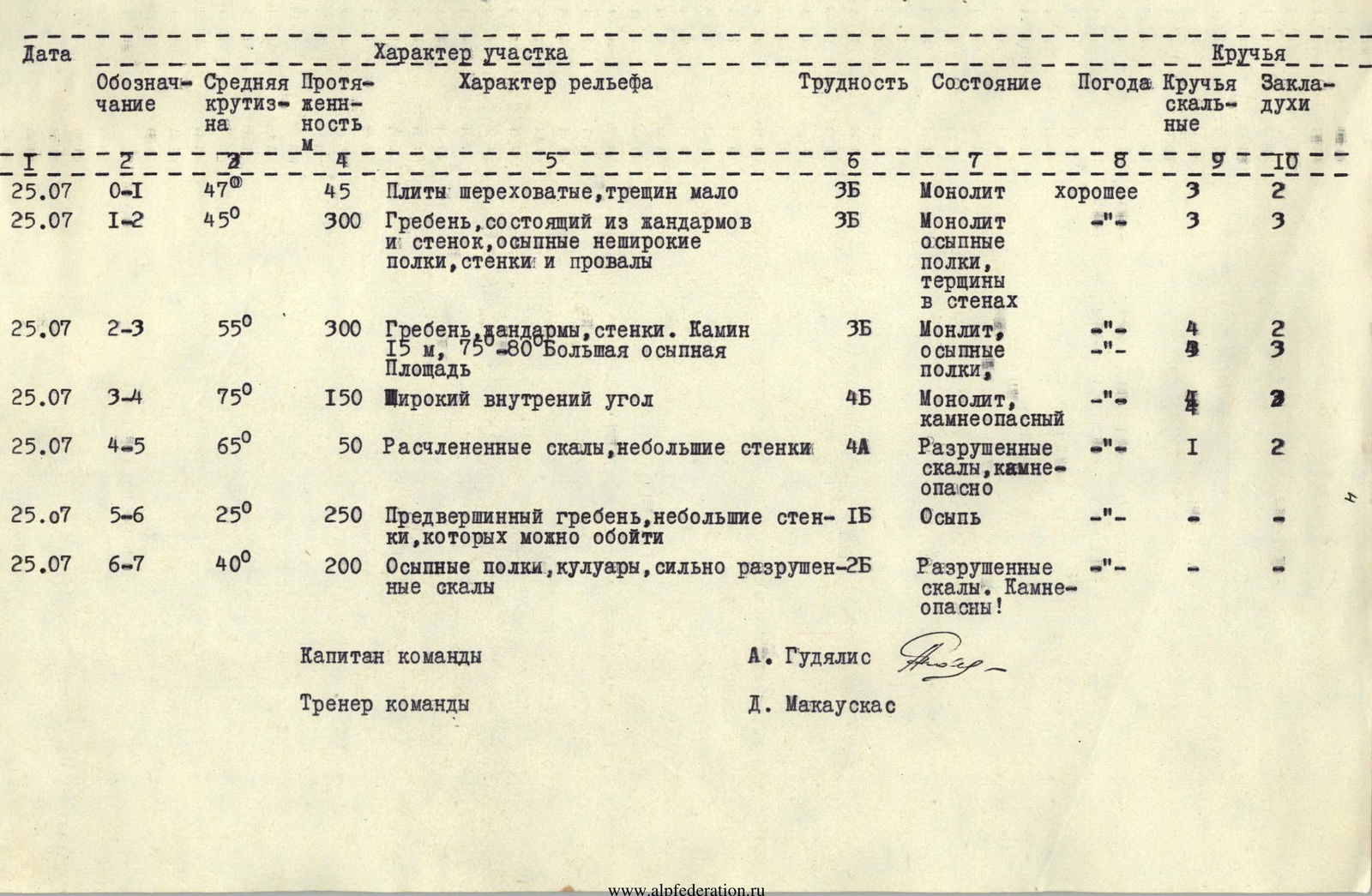
Table of main characteristics of the ascent route
| Date | Designation | Average steepness | Length, m | Character of section | Character of relief | Difficulty | Condition | Weather | Rock pitons | Chocks |
|---|---|---|---|---|---|---|---|---|---|---|
| 25.07 | R0–R1 | 47° | 45 | Rough slabs | few cracks | 3Б | Monolith | good | 3 | 2 |
| 25.07 | R1–R2 | 45° | 300 | Crest consisting of gendarmes | and walls, scree not wide shelves, walls and dips | 3Б | Monolith scree shelves, cracks in walls | " | 3 | 3 |
| 25.07 | R2–R3 | 55° | 300 | Crest, gendarmes, walls. Chimney | 15 m, 75°–80°. Large scree area | 3Б | Monolith, scree shelves | " | 4 | 2 |
| 25.07 | R3–R4 | 75° | 150 | Wide inner corner | 4Б | Monolith, stone-hazardous | " | 4 | 3 | |
| 25.07 | R4–R5 | 65° | 50 | Dissected rocks | small walls | 4А | Destroyed rocks, stone-hazardous | " | 1 | 2 |
| 25.07 | R5–R6 | 25° | 250 | Pre-summit crest | small walls that can be bypassed | 1Б | Scree | " | — | — |
| 25.07 | R6–R7 | 40° | 200 | Scree shelves, couloirs | strongly destroyed rocks | 2Б | Destroyed rocks. Stone-hazardous! | " | — | — |
| Team captain | ||||||||||
| A. Gudialis | ||||||||||
| Team coach | ||||||||||
| D. Makauskas | ||||||||||
 |