138
3 А pro5~499 0511/x-807
Ascent Log
- Ascent class: technical
- Ascent area: Pamir-Alay
- Peak, its height, ascent route: Peak 4200, 4200 m, via the northwestern ridge
- Proposed difficulty category: 3A
- Route characteristics: height difference – 900 m, average slope – 45°
- Pitons driven: for belay —; for creating RPE: rock — 6, ice — –, bolt — –.
- Number of climbing hours: 8 hours
- Number of overnight stays and their characteristics: none
- Surname, name, patronymic of the leader, participants, and their qualification:
- Klyokis Edvardas A. — 2nd sports category.
- Neverauskas Rimas B. — 2nd sports category.
- Podolinsky Alexander M. — 2nd sports category.
- Team coach: Dainius Makauskas
- Date of departure and return: July 20, 1980, July 29, 1980

- Route via the NW ridge, traversed by the group.
- Route via the N wall of Big Alla Tien Shan, B.B. K.T.R.
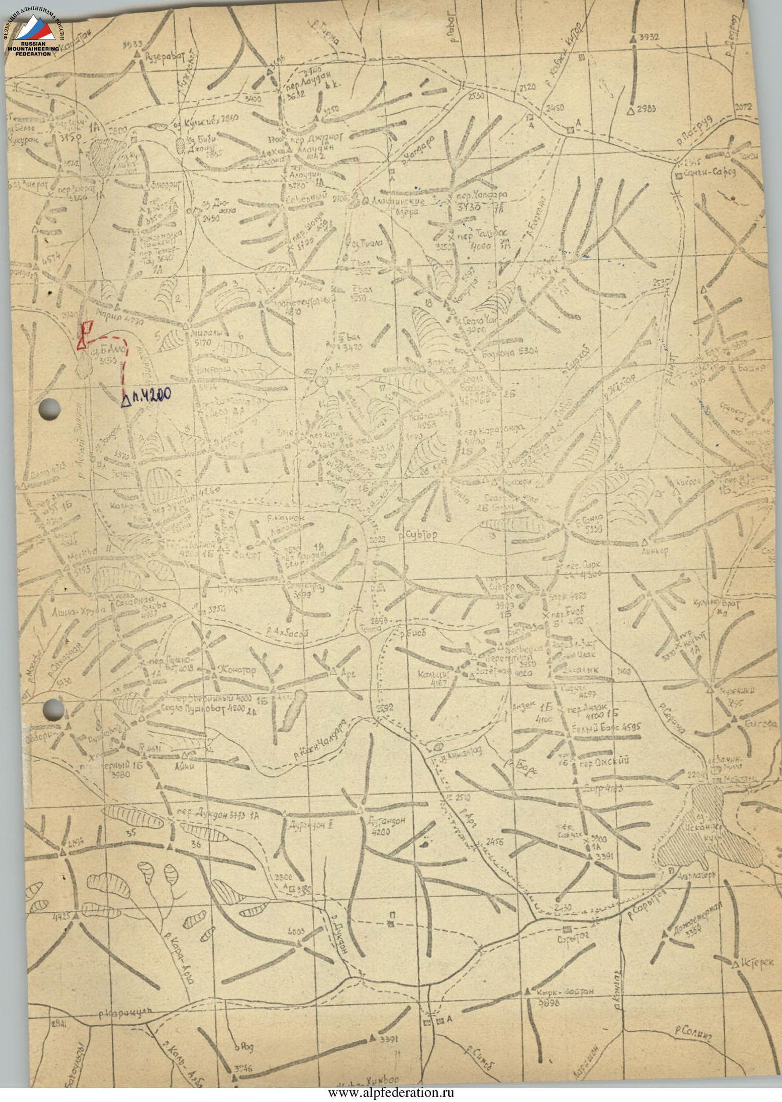
Description of the route to Peak 4200 m via the northwestern ridge
From the overnight stay at Big Alla — 50 minutes to the start of the route. From there, ascend to the ridge along moderately difficult rocks, belaying off protrusions. Traverse along the talus shelves on the right side of the ridge to the pre-summit tower. Along the way, watch out for loose rocks and scree. The route is clearly visible all the way to the top. Just before the summit, a wide chimney with an overhanging rock cornice is visible.
- 1st rope: traverse along the pre-summit tower and a gendarme ahead. The gendarme is taken "head-on" (pitons and protrusions for belay).
- Descent from the gendarme — under a "plug".
- Via a crack in the left rock wall — exit to a shelf before another rock wall.
- The wall is taken "head-on" (pitons for belay) — exit to the ridge.
- From there, along the shelves on the right side — ascend upwards via a small couloir to the first control cairn.
- From there, up the rock wall (pitons for belay) — to a chimney with rimed ice.
- On the right side of the couloir — 1st rope upwards (caution, loose rocks).
- Further, along the rocks to the right — exit to the summit plateau.
Descent via a scree-filled couloir towards the Left Zindon until the end of the pre-summit tower. From there, rightwards along the shelves, bypassing the pre-summit tower, descend via the ascent route.
Table of main characteristics of the ascent route
| Date | Designation of sections | Average slope | Length | Terrain characteristics | Recommended difficulty | Weather conditions | Rock pitons | Ice pitons |
|---|---|---|---|---|---|---|---|---|
| July 29, 1980 | R0–R1 | 30 | 300 | talus shelves | 2B | good | – | – |
| July 29, 1980 | R1–R2 | 50 | 40 | gendarme | 3A | – | 2 | – |
| July 29, 1980 | R2–R3 | 60 | 80 | rocks, wall | 3B | – | 2 | – |
| July 29, 1980 | R3–R4 | 35 | 200 | couloir | 3A | – | – | – |
| July 29, 1980 | R4–R5 | 50 | 180 | broken rocks, chimney | 3B | – | 2 | – |
| July 29, 1980 | R5–R6 | 45 | 100 | couloir, broken rocks | 3A | – | – | – |