Ascent Passport
- Ascent class: rock climbing.
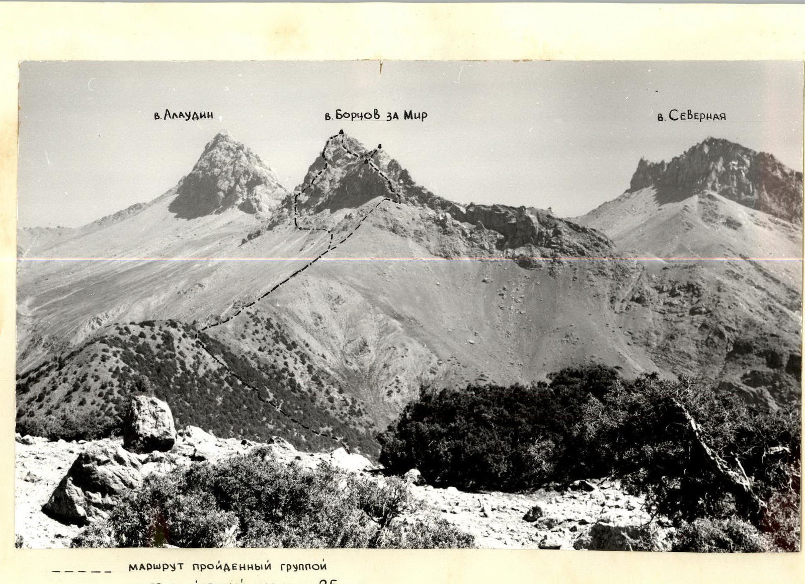
- Ascent area: Zarafshan Range, Fann Mountains.
- Peak, its height, ascent route: peak Bortsov za Mir, 3800 m, via the northwestern spur of the western ridge.
- Proposed difficulty category: 2B.
- Route characteristics: elevation gain — 400 m (3400–3800 m); total route length — 1400 m; average steepness of key sections — 60°;
- Number of pitons (including chocks): for belays — 16.
- Total climbing hours: 4.5 hours.
- Number of nights and their characteristics: none.
- Team composition:
- Malygin V.V., leader, 1st sports category.
- Valiulin E.A., participant, Master of Sports of the USSR.
- Gerasimov G.N., participant, 1st sports category.
- Grachenko V.P., participant, 1st sports category.
- Ivanina V.B., participant, 2nd sports category.
- Team coach: Head of the Tourist Sports Complex (KSP) in the Fann Mountains, Mumdzhi T.M.
- Date of departure and return: departure — July 25, 1986, return — July 25, 1986.
- Organization: KSP in the Fann Mountains.

Brief Description of the Approach to the Route
From Lake Bibi-Dzhonat, ascend along the grassy slopes covered with sparse juniper forest towards the northwest spur of peak Bortsov za Mir. Continue along the ridge, which is covered with small scree, directly under the western wall of peak Bortsov za Mir (1.5 hours). Exit under the route to the right of the vertical slab (see photo #1).
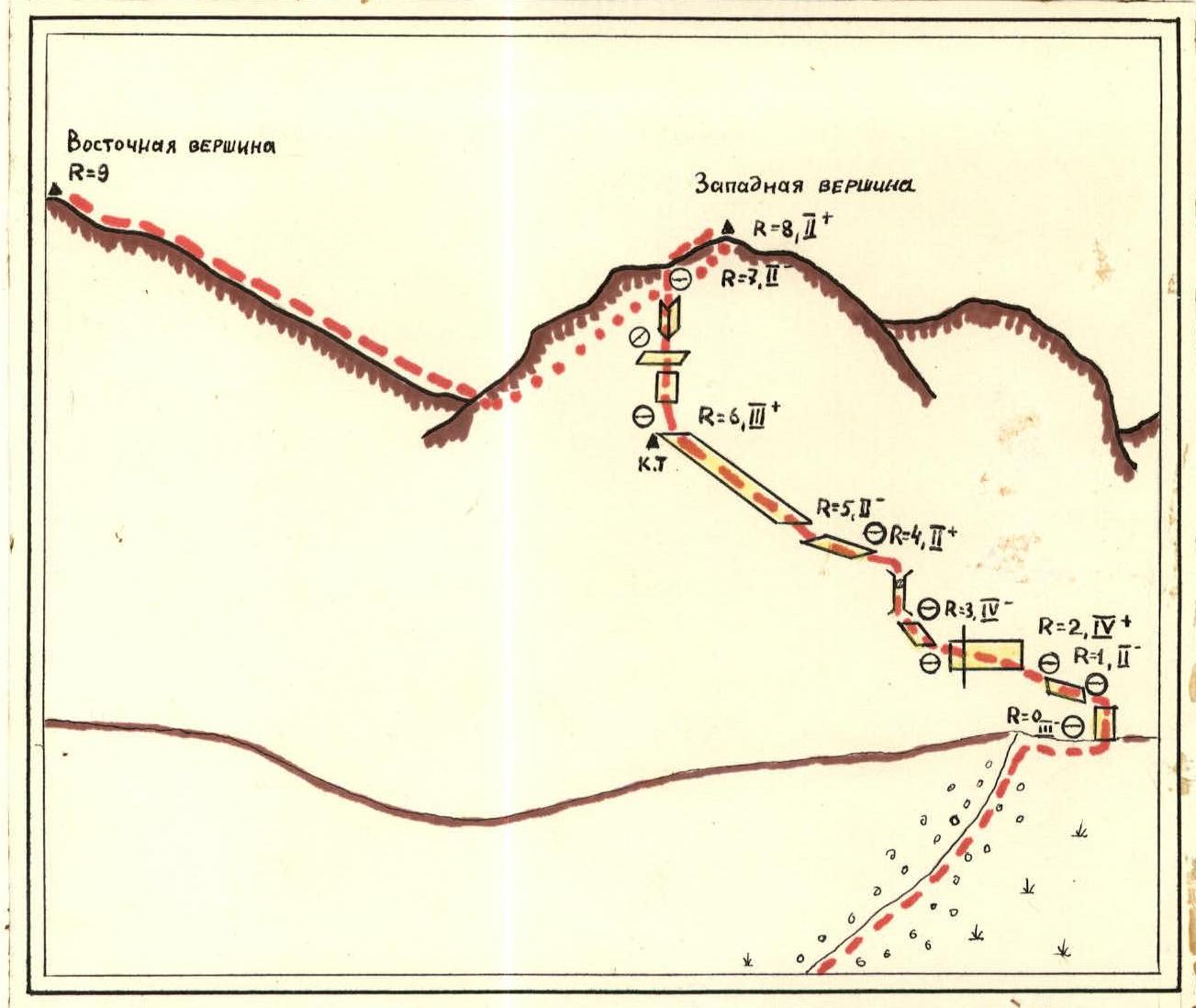
Brief Description of the Route Diagram
Section R0–R1: Ascend a simple wall (6 m) with numerous holds, approximately 60° steep, to reach an inclined scree ledge. Belay via protrusions, alternating.
Section R1–R2: Traverse the scree ledge left and upwards to a horizontal slab. Movement is alternating, with belays via protrusions (20 m).
Section R2–R3: The key section of the route (photo #3). Traverse a vertical slab leftwards, via a rib (20 m). Difficult climbing, piton belays. At the point of crossing the rib, it's recommended to use artificial footholds (chocks). Exit under a chimney.
Section R3–R4: Climb a chimney with a plug (10 m). Piton belays, monolithic rocks with few holds. Continue left and upwards to a horizontal slab via simple rock.
Section R4–R5: Traverse a horizontal slab (30 m). Monolithic rocks, piton belays, alternating movement. Exit onto a wide scree ledge.
Section R5–R6: Ascend the scree ledge leftwards and upwards. Movement is simultaneous and, in some sections, alternating with belays via protrusions on a vertical slab. Many "live" rocks. At the end of the scree ledge, there's a control cairn (photo #4). The scree ledge abuts a vertical slab with a rock ledge and an internal angle, leading to the pre-summit ridge.
Section R6–R7: Climb a slab (6 m) and an internal angle (5 m) to reach the ridge. Piton belays, alternating movement.
Section R7–R8: Ascend the ridge via simple rock to reach the western summit of peak Bortsov za Mir (20 m). Control cairn. Monolithic rocks, simultaneous movement.
Section R8–R9: Descend along the ridge to the saddle between the western and eastern summits of peak Bortsov za Mir. Continue along the ridge to the eastern (main) summit via simple and moderately difficult rock. Simultaneous movement with belays via protrusions. On the summit, there's a control cairn.
DESCENT FROM THE SUMMIT: follow the ascent path to the saddle between the western and eastern summits of peak Bortsov za Mir. Continue down the small scree slopes southwards to the trail leading to Lake Bibi-Dzhonat.
Ascent Leader V. Malygin, V. Malygin.
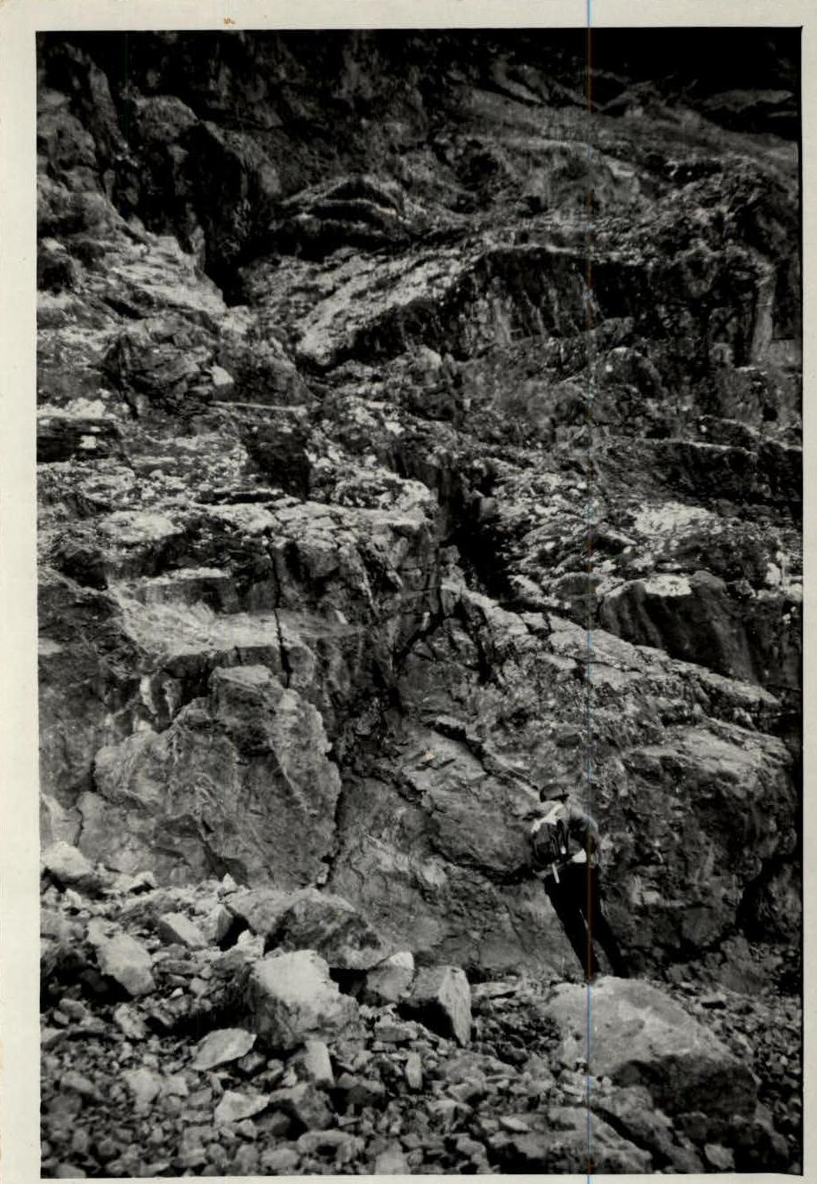
PHOTO # 1
Exit to the route.
Brief Description of the Approach to the Route
Peak GARDISH (4590 m) is located in the Fann Mountains (Zarafshan Range), in the southwestern corner of this mountain node.
From the "Artuch" tourist base, descend along the Kishtut River valley to the confluence of the Voru and Kishtut rivers. Turn left and ascend along the Voru River valley to the confluence of the Sarymat and Archa-Maydan rivers, Duoba. From Duoba, turn right and follow the Sarymat River valley to the village of Khumarigum. The car journey from "Artuch" tourist base to Khumarigum takes 2–2.5 hours (about 45 km).
Continue on foot along the Sarymat River valley to the confluence of the Sarymat and Obisafed rivers — 2–2.5 hours. From here, the Tavsang and Munora passes and the northwestern slopes of the Gardish massif are visible.
Follow the left (orographic) bank of the Obisafed River along a trail leading to the Munora pass, and exit into the Gardish cirque — 2–2.5 hours.
First, follow the lateral moraine, then ascend the gentle glacier to the median transverse moraine opposite the central part of the northern wall of peak Gardish — 45 minutes.
Here, a storm bivouac is set up for the climbing group, and a observation and radio communication point is established.