Ascent Passport
I. Ascent category — technically challenging.
2. Ascent area — Fan Mountains.
3. Route — peak S. Bodhona (5300 m) via N. wall, 5B category of complexity («Kudinov I.B. route, 1968, 3rd ascent»)
4. Ascent characteristics:
route length — 3270 m
height difference — 2100 m
average steepness — 75°
length of difficult sections — 520 m, VI category of complexity
5. Pitons driven:
rock (including stoppers) — 220
ice — 4
6. Number of climbing hours — 40 h
7. Number of nights — 4 (all comfortable)
8. Number of climbing days — 5
9. Team of LGS DOO «Spartak»
10. Team coach Kolchin A.A. MSMK
11. Team members:
Kruglov Evgeny Mikhailovich — team leader, CMS
Zhukov Sergey Yakovlevich — CMS
Malinovsky Andrey Igorevich — 1st sports category
Neplokhov Andrey Dmitrievich — 1st sports category
12. Ascent date — July 21, 1979 – July 26, 1979

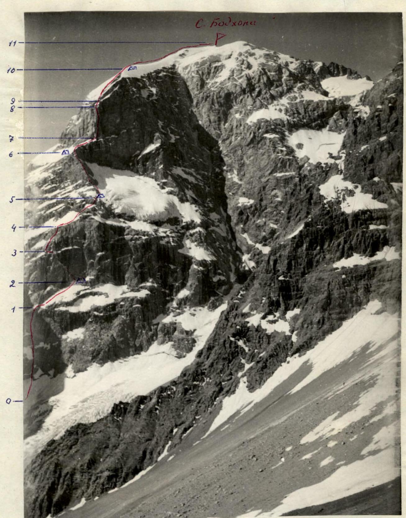
Route to peak S. Bodhona via N. wall.
Route description to peak S. Bodhona via N. wall
«Kudinov route, 1970»
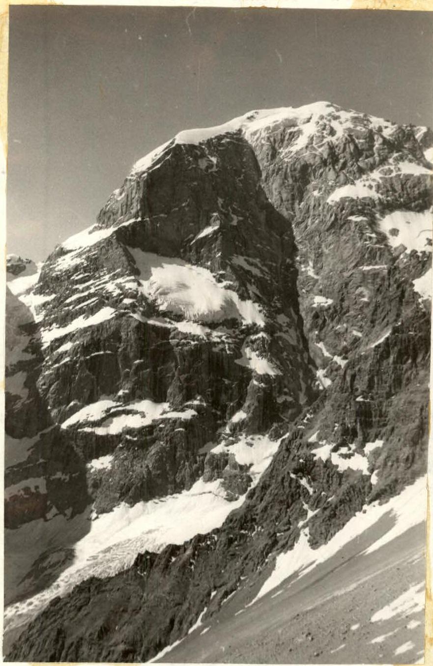
The Northern wall of peak S. Bodhona is cut by a giant couloir into two parts. To the left of the couloir, in the center of the wall, there is a hanging glacier. To the left of the glacier, at its level, there is a ridge that drops down to the glacier with a wall divided by a large snow shelf into two ascents. The route follows this wall, then along the ridge and straight up the second wall, which the ridge abuts. The first ascent of the lower wall is made in the left part, where the rocks are somewhat less steep than in the center. Above the right part of the wall hangs the aforementioned glacier, and from the eastern ridge of the peak to the left of the route, another glacier hangs. The falling ice from it limits the route to the left.
The base of the route — a bergschrund according to our altimeter is at an altitude of 3200 m (according to Kudinov's estimates — 3500 m). After the first ascent (section R0–R1, 400 m, V category of difficulty), the route goes along a steep snow shelf to the right and up to the highest point of the shelf, after which the shelf begins to descend. There is a good bivouac site there (3700 m). On the shelf (section R1–R2, 360 m, IV–V category of difficulty), protection is via ice axe, sometimes via rock pitons and sometimes from a running belay. To the bivouac site from the bergschrund takes 6 climbing hours. The second ascent of the wall is overcome by a large chockstone to the left and up from the bivouac (section R2–R3, 250 m, VI category of difficulty). This section is a series of very difficult walls, but with good ledges between them. In several places, the route passes under waterfalls from the right wall. It is recommended to pass this section in the morning, before the waterfalls gain strength. The chockstone leads to a shelf. Along the shelf to the left 25 m. Then to the right and up to the next large snow shelf (section R3–R4, 150 m, V–VI category of difficulty). Along the snow shelves with rock walls to the right and up (section R4–R5, 170 m, IV–V category of difficulty). The main landmark on this section is the beginning of the ridge. On the ridge is the second bivouac site (altitude 4100 m). In total, 10 climbing hours were spent on section R2–R5 for the day. Along the ridge, the first 2–3 ropes are relatively easy. Then it gets more difficult up to V category of difficulty (section R5–R6; 440 m, IV–V category of difficulty). Before the upper bastion, there is a good platform. Here is a bivouac site and a control cairn in a tin can on the wall near the platform. For the day, 4 ropes of the upper bastion were passed. From the bivouac site to the bastion:
- 100 m
- snow with rock outcrops (section R6–R7, I category of difficulty) On the bastion, there is a seemingly sheer counterfort, which is a continuation of the ridge. It divides the wall of the bastion into NE and NW walls. The first ascenders climbed slightly to the left of the crest. We chose a route slightly to the right. Bypass to the right and up — the base of the counterfort, then to the left and up along the stream (between the stream and the crest, with an exit to the crest). The last rope of this section is straight along the crest. The entire section: R7–R8, 320 m, VI category of difficulty. Further:
- Along the snow-ice slope (section R8–R9, 120 m, IV category of difficulty, 3 ice pitons)
- To the wall leading to the edge of the rock-snow-ice slope (section R9–R10, 240 m, IV–V category of difficulty) Rocks like tiles, sometimes snow-covered and iced. The path goes along the edge to the exit to the ice crest. Two ropes along the crest and on its right side — on a scree platform is a bivouac site. Altitude 5000 m. For the day (12 h), sections R6–R10 were passed. From the bivouac site to the summit along the ice crest (section R10–R11, 700 m, III category of difficulty, 3 h). Descent from the summit 40 m along the W ridge towards Chapdara and to the left into the couloir. Having descended 40 m, traverse to the left and then down into the large couloir descending from the saddle between the N peak and the large gendarme («the gendarme is marked as the central peak of the Bodhona massif on some maps»). The descent is mainly via rappel to the glacier. Then down to the serac zone and along it to the right and down under the slopes of Chapdara and along the snowfields down to the trail. The descent to the trail takes 4–5 h.
Table of technical characteristics of the route
| Date | Section | Steepness | Length in m | Terrain characteristics | Category of difficulty | Condition | Rock pitons | Ice pitons, stoppers and slings | Total for the day (climbing hours and height difference) |
|---|---|---|---|---|---|---|---|---|---|
| July 22 | R0–R1 | 70 | 400 | Rock wall | V | Monolith | 12 | 10 | 6 climbing hours |
| July 22 | R1–R2 | 45 | 360 | Snow shelf | IV–V | 10 | 7 | 3700–3200=500 m | |
| July 23 | R2–R3 | 80 | 250 | Rock wall | V–VI | Monolith, wet | 29 | 6 | 10 climbing hours |
| July 23 | R3–R4 | 70 | 150 | Rock wall with shelves | V–VI | Monolith, wet | 10 | 15 | |
| July 23 | R4–R5 | 50 | 170 | Snow shelves with rock walls | IV–V | 6 | 9 | 4100–3700=400 m | |
| July 24 | R5–R6 | 50 | 440 | Rock ridge | IV–V | Monolith, tiles | 22 | 20 | 5 climbing hours + 4 h processing 4600–4100 = 500 m |
| July 25 | R6–R7 | 40 | 100 | Snow with rock outcrops | III | - | 3 | 12 climbing hours | |
| July 25 | R7–R8 | 85 | 320 | Rock wall | VI | Monolith | 32 | 25 | |
| July 25 | R8–R9 | 35 | 120 | Snow-ice | II | Thin snow on ice | - | 4 | |
| July 25 | R9–R10 | 35 | 240 | Slabs to the left of the edge | IV | Monolith, snow-covered and iced | 16 | - | 5000–4600=400 m |
| July 26 | R10–R11 | 30 | 700 | Ice ridge | III | Ice with small cal-gaspores | 3 climbing hours 5300–5000 = 300 m |