Passport
- Category of ascent — High-altitude technical.
- Region of ascent — Pamir. Fann Mountains.
- Route of ascent — Mt. Bodkhona 5304 m via the right part of the wall, category 5B (Kolchin).
- Characteristics of the ascent: height difference — 1500 m; length of complex climbing — 1300 m; average steepness — 65°.
- Pitons hammered in: rock — 122, ice — 1, bolt — 6, placed elements — 33.
- Number of travel hours — 33.
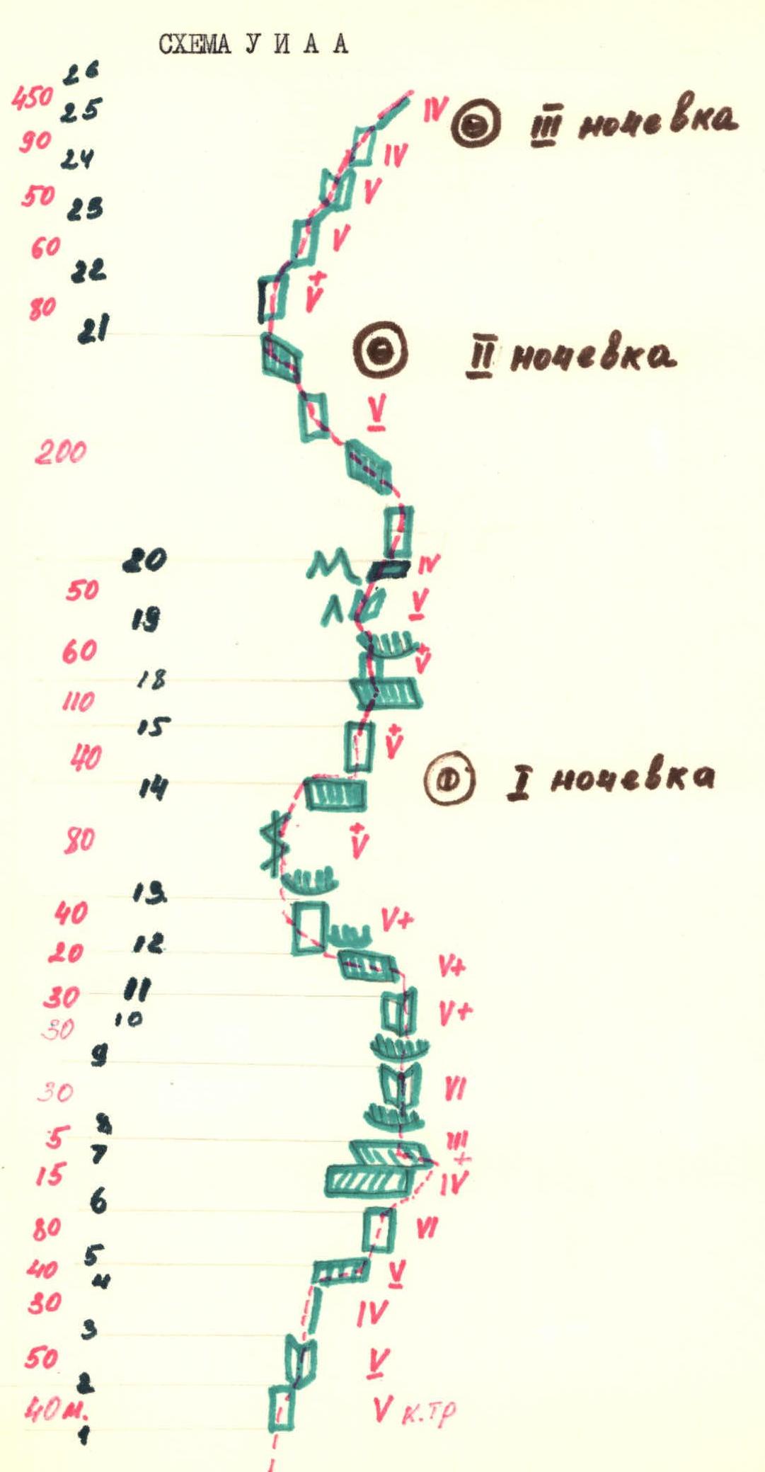
- Number of bivouacs and their characteristics:
Total — 3.
- 1 — rock ledge, sitting.
- 2 — ledge for a tent.
- 3 — ledge on the ridge.
- Team name: Voronezh team of Voronezh Regional Council "Zenit".
- Team members: Aksenov V.N. — Candidate Master of Sports, Korenyugin I.K. — Candidate Master of Sports, Prilepina T.M. — Candidate Master of Sports, Dronov Yu.S. — 1st sports rank.
- Team coach: Master of Sports of the USSR Zaev E.F.
- Dates: departure on the route — August 17, 1982,
return — August 20, 1982.
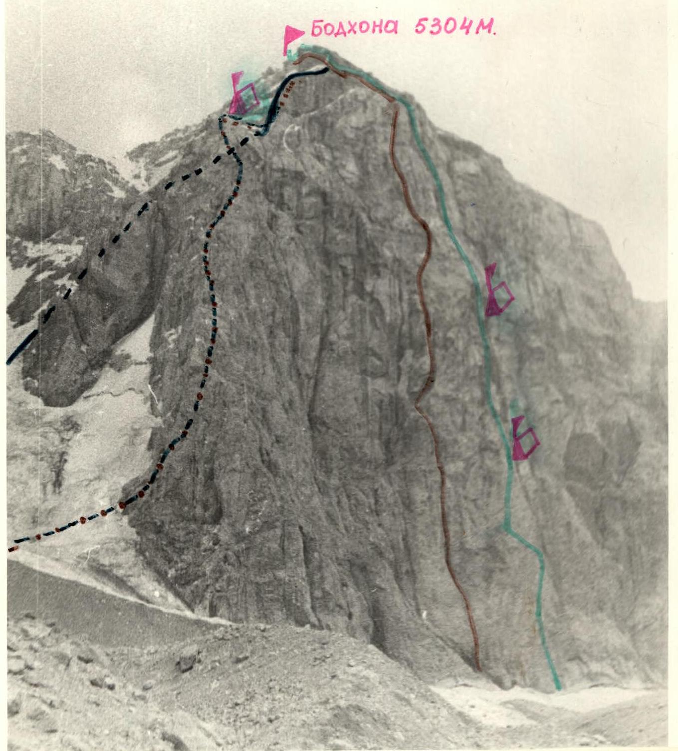
Photo from the ridge in Chandara.
Description of the route
The route passes through the center of the wall. In its lower part, it follows the central buttress, the "bottle". In the upper part, it follows the central large cleft, the "canyon". In the right part of the "bottle", a chimney-slot is visible, leading upwards to the "neck" of the "bottle". The chimney begins 30 meters from the base of the "bottle" in a large niche. Then, after exiting from under the cornice, it follows the wall, slightly to the left of the chimney, to a niche. After the cornice, it follows the chimney or to the left of it to the level of the "gendarme". From its summit, 30 meters upwards into a niche, and from there to the "neck" of the "bottle". From the "neck" upwards, there are laid out platforms. Upwards and to the left through a small cornice — into a cave. From the cave, upwards and slightly to the right, a steep ledge goes, following it for 30 meters, then directly upwards through an internal corner with an exit onto a wide ledge going to the left. The ledge leads into a dead end. Movement directly upwards through an internal corner turning into a ledge, which leads steeply to the left upwards. Following it, ascent to wide ledges of Sidelnikov's route. Along these ledges to a cornice, then upwards through slabs or through a cleft next to black streaks to easier stepped rocks, leading to a platform under a sheer wall with black streaks. The beginning of the ascent is 15 meters to the left of the platform, then upwards to the right to a large ledge under the canyon. Under overhanging green rocks — a platform. Further, following the canyon, ascent to a large talus ledge. This is the end of the wall. Height — 5000 m. Further, there is another wall, and then along the ridge to the summit.
Table №1
Main characteristics of the route
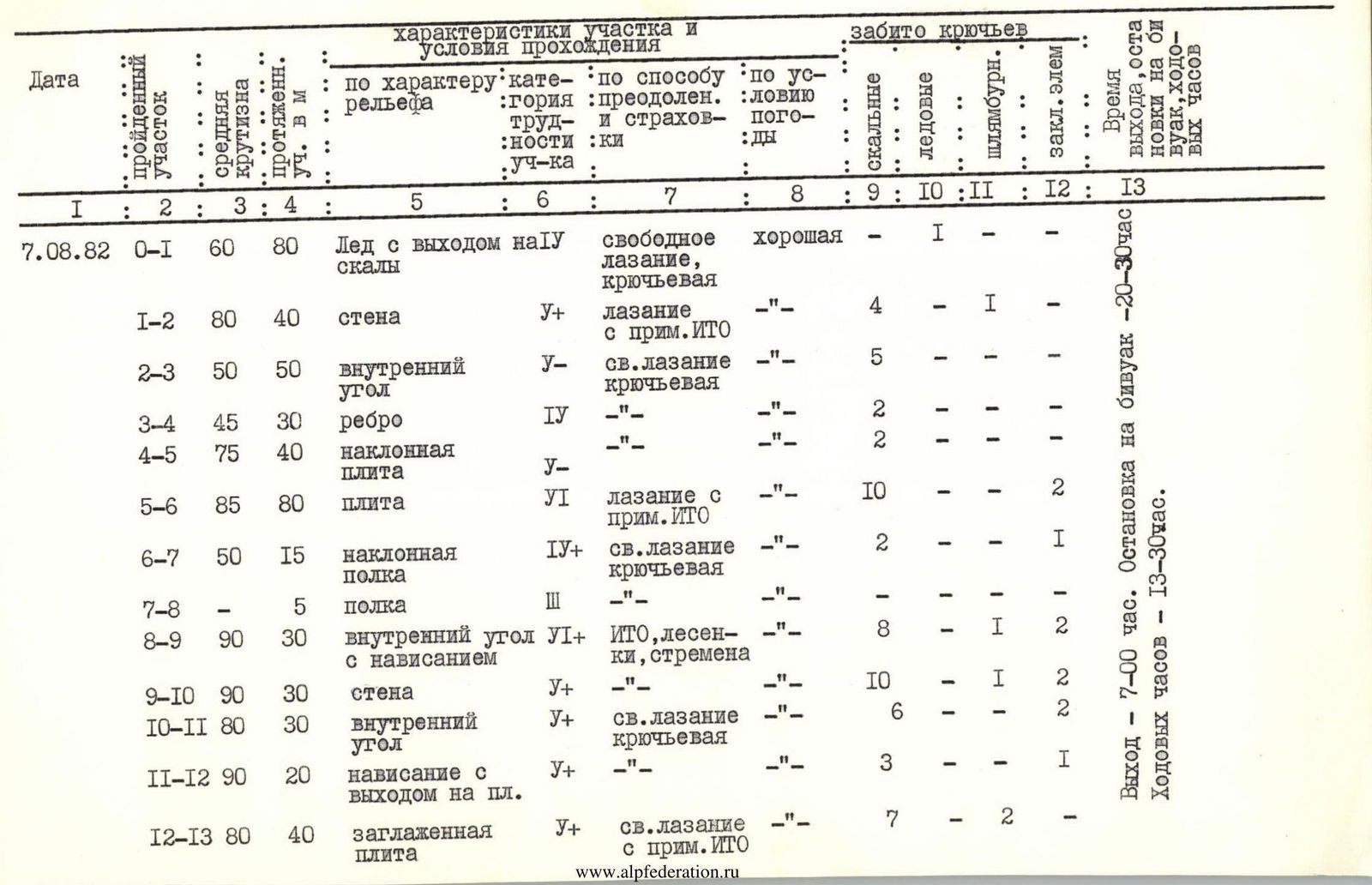
| Date | Section traversed | Average steepness | Length of section in m | Nature of terrain | Category of difficulty of section | Method of overcoming and belay | Weather conditions | Rock pitons | Ice pitons | Bolt pitons | Placed elements | Time of departure, stop for bivouac, travel hours |
|---|---|---|---|---|---|---|---|---|---|---|---|---|
| August 7, 1982 | R0–R1 | 60 | 80 | Ice with an exit onto rocks | 4 | free climbing, piton belay | good | - | 1 | - | - | |
| R1–R2 | 80 | 40 | wall | 5 | climbing with aid | -" | 4 | - | 1 | - | ||
| R2–R3 | 50 | 50 | internal corner | 5 | free climbing, piton belay | -" | 5 | - | - | - | ||
| R3–R4 | 45 | 30 | edge | 4 | -" | -" | 2 | - | - | - | ||
| R4–R5 | 75 | 40 | inclined slab | 5 | -" | -" | 2 | - | - | - | ||
| R5–R6 | 85 | 80 | slab | 6 | climbing with aid | -" | 10 | - | - | 2 | ||
| R6–R7 | 50 | 15 | inclined ledge | 4 | free climbing, piton belay | -" | 2 | - | 1 | - | ||
| R7–R8 | - | 5 | ledge | 3 | -" | -" | - | - | - | - | ||
| R8–R9 | 90 | 30 | internal corner with overhang | 6 | aid (ladders, stirrups) | -" | 8 | - | 1 | 2 | ||
| R9–R10 | 90 | 30 | wall | 5 | -" | -" | 10 | - | 1 | 2 | ||
| R10–R11 | 80 | 30 | internal corner | 5 | free climbing, piton belay | -" | 6 | - | - | 2 | ||
| R11–R12 | 90 | 20 | overhang with exit onto slab | 5 | -" | -" | 3 | - | - | 1 | ||
| R12–R13 | 80 | 40 | smoothed slab | 5 | free climbing with aid | -" | 7 | - | 2 | - | Departure — 7:00. Stop for bivouac — 20:30. Travel hours — 13 h 30 min. | |
| August 8, 1982 | R13–R14 | 80 | 80 | cleft, exit from under overhang | 5 | free climbing, piton belay | good 2 | - | - | 2 | - | |
| R14–R15 | 80 | 40 | wall | 5 | -" | -" | 4 | - | - | 1 | ||
| R15–R16 | 75 | 40 | -" | 5 | -" | -" | 6 | - | - | 1 | ||
| R16–R17 | 80 | 80 | slab | 5 | free climbing with aid | -" | 4 | - | - | - | ||
| R17–R18 | 50 | 30 | inclined ledge | 4 | free climbing | -" | - | - | - | - | ||
| R18–R19 | 60 | 60 | internal corner | 5 | -" piton belay | -" | 5 | - | - | 3 | ||
| R19–R20 | 55 | 50 | ledge | 4 | -" | -" | 2 | - | - | 1 | ||
| R20–R21 | 60 | 200 | alternation of walls and ledges | 5 | -" | -" | 8 | - | - | 4 | Departure — 7:00. Stop for bivouac — 18:30. Travel hours — 11 h 30 min. | |
| August 9, 1982 | R21–R22 | 70 | 80 | slab | 5 | -" | -" | 4 | - | - | 2 | |
| R22–R23 | 80 | 60 | wall | 5 | -" | -" | 5 | - | 1 | 2 | ||
| R23–R24 | 70 | 50 | canyon | 5 | -" | -" | 3 | - | - | 2 | ||
| R24–R25 | 60 | 90 | wall with exit onto ridge | 5 | -" | -" | 5 | - | - | 3 | ||
| R25–R26 | 45 | 450 | summit ridge | 4 | -" | -" | 8 | - | - | 2 | Departure — 7:30. Reach summit — 17:30. Stop for bivouac — 18:30. |
Brief explanation for the table of main characteristics
Section R0–R1
- Ice covered with snow.
- Simultaneous movement with piton belay.
Section R1–R2
- Vertical wall with black streaks.
- Passed on "mizerakh" (small pitons).
Section R2–R3
- Internal corner going upwards to the right.
- Free climbing, piton belay.
- The corner leads to an edge.
Section R3–R4
- Edge going upwards to the right.
- Piton belay.
Section R4–R5
- Inclined slab-ledge going upwards to the right.
- Free climbing, piton belay.
- To the left — black rock with an overhang.
Section R5–R6
- Smooth slab.
- Climbing on friction.
- Piton belay.
- Movement upwards to the right.
Section R6–R7
- Inclined ledge.
- Leads to the right part of the "bottle".
Section R7–R8
- Horizontal ledge.
- Place for overnight stay.
Section R8–R9
- Internal corner with overhang.
- Passed using aid (ladders, stirrups).
- Belay — bolt pitons.
Section R9–R10
- Traverse along the wall from right to left.
- Initially along a ledge turning into a crack on a vertical wall to an internal corner.
Section R10–R11
- Internal corner.
- Rocks are destroyed.
- Movement to the left upwards.
- To the right — smooth gray wall.
- Exit to the left onto an edge (the "neck" of the "bottle").
Section R11–R12
- Smooth wall 8 m.
- Initial movement upwards with a boost to a bolt piton.
- Exit to the left onto an edge.
- Belay — bolt pitons.
Section R12–R13
- Smooth slab (shoulder of the "bottle") leading to the "neck".
- To the right above — an overhang.
- To the left — smooth internal corner.
- Movement along the middle of the slab through a crack.
- Exit from under the overhang to the right.
Section R13–R14
- Gray wall.
- To the left above — a large cornice.
- Climbing through a cleft, piton belay.
- Exit onto a narrow ledge partially covered by a rock canopy.
- Bolt pitons are present.
- Place for overnight stay.
Section R14–R15
- Wall.
- Beginning of movement from the platform through an internal corner, then directly upwards to a cave.
Section R15–R16
- Inclined ledge going upwards to the right.
- Rocks are icy.
- First climber moves along the edge.
Section R16–R17
- Wall.
- To the left and above — an overhang.
- Movement upwards under the overhang, then — traverse to the right.
Section R17–R18
- Inclined ledge.
- Free climbing, piton belay.
Section R18–R19
- Movement along a ledge.
- Not reaching the internal corner, upwards through a crack.
Section R19–R20
- Exit onto a ledge.
- Further — movement along the center of the wall to the left upwards to wide ledges.
Section R20–R21
- Wall represents an alternation of ledges and walls.
- Ascent to a visible cornice.
- The cornice is overcome by free climbing.
Section R21–R22
- After the cornice — exit onto a slab.
- Along it directly upwards through a cleft to stepped rocks.
- Place for overnight stay.
Section R22–R23
- Wall with black streaks.
- Ascent along the center of the wall.
- Piton belay.
Section R23–R24
- Movement along a canyon to a ledge.
Section R24–R25
- Beginning of movement along a ledge to the left upwards.
- Then — along the wall to a visible ridge.
Section R25–R26
- Movement along the ridge to the summit.
- Piton belay.