30a
Passport
Kolcherek Route
-
Class: technical.
-
Fann Mountains.
-
Peak Bodkhona, 5304 m, via the right part of the West Face, rock climbing.
-
Cat. difficulty 5B.
-
Height difference 834 m, route length 1763 m, wall section 983 m.
Section lengths:
- 5th cat. diff. — 616 m
- 6th cat. diff. — 226 m
Average slope of the route — 52°, average slope of the wall section — 65°.
-
Number of pitons:
- rock: 118/11
- chocks, friends: 161/10
- ice screws: 4/0
-
Total climbing time: 27 h 20 min.
-
Overnight stay: one — on a ledge, lying down.
-
Team leader:
- Moroz Sergey Andreyevich MS/1st sports category (rock climber)
- Timofeev Vladimir Nikolaevich MS/MS (rock climber)
- Khitrikov Vladimir Andreyevich MS/KMS (rock climber)
- Lebedev Gennadiy Igorevich MS/1st sports category (rock climber)
- Portyanko Grigory Andreyevich KMS/KMS (rock climber)
- Pavlysh Sergey Nikolaevich KMS/1st sports category (rock climber)
-
Coach: Kozak Leonid Romanovich, MS.
-
Approach to the route: August 10, 1987.
Summit: August 11. Return: August 12, 1987.
-
Organization: Alpinist club "Dnepropetrovsk", Dnepropetrovsk regional council of DRSO.
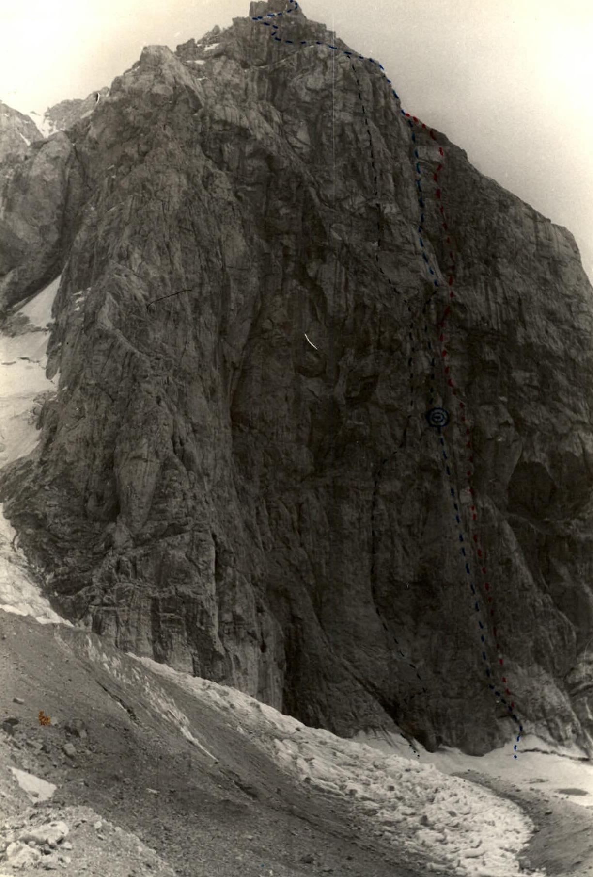
Photo #1. Lens type Industar-30. Shooting point #1, elevation 3800 m. Date of shooting July 25, 1980. Distance to the object 2000 m.
- — Team's route
- –– Volodarchik's route
- ––– Senchina's route
Tactical Actions of the Team
The tactical plan was to complete the route in two days without prior processing:
- day — traverse the lower part of the wall (section R1–R27), reach a niche, set up a bivouac, process the wall (section R28–R36).
- day — traverse the processed ropes in the upper part of the wall (section R37–R56), traverse the "roof" (section R57–R61).
The team largely followed the planned tactical plan. However, during the ascent, the team's tactical actions were adjusted. As they approached the chimney on the ledge above R45, the area was being bombarded with rocks and ice from the upper part of the chimney, and the weather deteriorated (it started snowing at 15:20), so in accordance with the backup plan for bad weather and to ensure safety, the upper tower was climbed via its right part.
In terms of terrain and rock structure, the right chimney is similar to the left one. However, due to the absence of ice in the middle and upper parts (photo #4), from which rocks and ice fall, it was safer to climb in the given weather conditions.
The division of teams and rotation of lead teams by day and within the day were as follows:
- By days
- Within a day
-
day:
- Timofeev — Moroz team #1, section R0–R27
- Portyanko — Pavlysh team #3, section R28–R36
-
day:
- Khitrikov — Lebedev team #2, section R37–R56
- Portyanko — Pavlysh team #3, section R57–R61
Thus, the work time for the lead climber was reduced to 10 hours. For a challenging wall that requires significant physical and psychological strain, reducing work time and having interchangeable teams was a crucial factor in maintaining a good pace and ensuring safety.
The first team worked with a double rope. At belay stances, all pitons were backed up with a separate sling, which prevented rope breakage and increased the working length of the rope by 2–3 m.
On the wall section of the route, they left fixed ropes. To simplify and speed up the movement of the second climber in the lead team:
- they straightened out the fixed ropes,
- created intermediate anchor points.
Teams moved along the fixed ropes, additionally belaying themselves with a team rope passed through intermediate carabiners. When moving and setting up belay stances, chocks were most frequently used.
The work and rest schedule is detailed in the ascent time graph. The average work time on the route was 13–14 hours per day. The overnight stay was on a comfortable platform in a closed niche.
Safety measures:
- The first climber moved on a double rope (one — UIAA, the second — with a BEP compensator)
- Belaying through an "8" descender
- Backing up all carabiners at belay stances
- Using extenders with shock-absorbing components
- When moving on fixed ropes — "Jumar" ascenders in combination with a Prusik knot
There were no falls or injuries during the ascent. To overcome challenging sections, the team fully utilized their experience, technical skills, and physical fitness, which allowed them to complete the route at a good pace, with a sufficient margin of safety, and with maximum use of free climbing.
Communication with observers and within the group was regularly maintained using a 70 RPP-2 ChM radio station.
Table of Food and Fuel Supplies
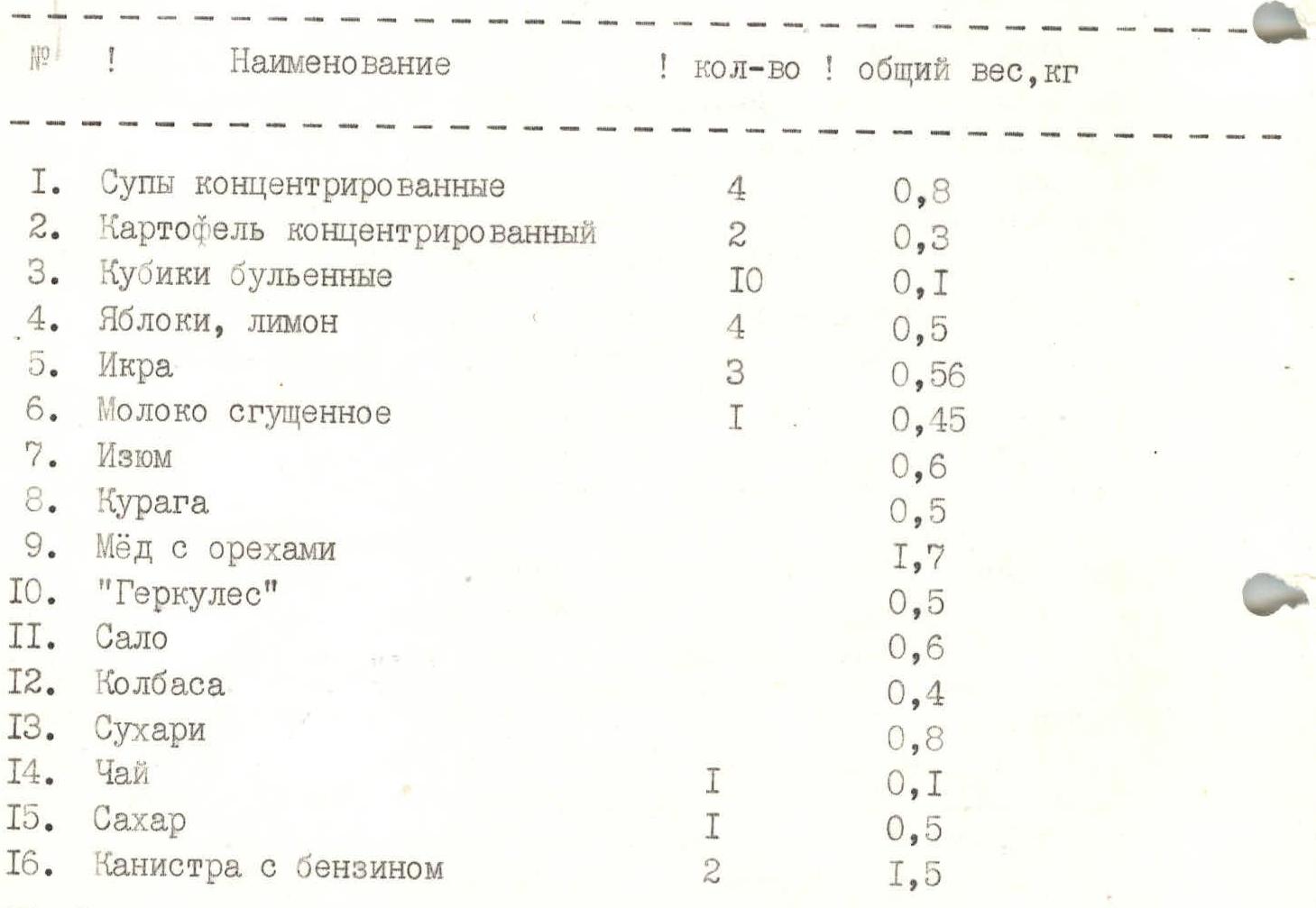
| Item | Quantity | Total weight, kg |
|---|---|---|
| 1. Concentrated soups | 4 | 0.8 |
| 2. Concentrated potatoes | 2 | 0.3 |
| 3. Bouillon cubes | 10 | 0.1 |
| 4. Apples, lemon | 4 | 0.5 |
| 5. Caviar | 3 | 0.56 |
| 6. Condensed milk | 1 | 0.45 |
| 7. Raisins | - | 0.6 |
| 8. Dried apricots | - | 0.5 |
| 9. Honey with nuts | - | 1.7 |
| 10. "Hercules" oatmeal | - | 0.5 |
| 11. Lard | - | 0.6 |
| 12. Sausage | - | 0.4 |
| 13. Rusks | - | 0.8 |
| 14. Tea | 1 | 0.1 |
| 15. Sugar | 1 | 0.5 |
| 16. Gasoline canister | 2 | 1.5 |
Total weight of food supplies 8.4 kg. Weight of backpacks on the route for the 2nd, 3rd, 4th, 5th participants — 6.7 kg. Weight of the last participant's backpack — 4.2 kg.

Route Diagram in UIAA Symbols
- R0
- R1, V, 38 m, 60°
- R2, V, 40 m, 60°
- R3, IV, 40 m
- R4, VI, 10 m, 90°
- R5, VI, A3, 5 m, 95°
- R6, V, 23 m, 70°
- R7, V, 35 m, 70°
- R8, V, 10 m, 70°
- R9, V, 10 m, 85°
- R10, V, 20 m, 70°
- R11, VI, 7 m, 90°
- R12, VI, 10 m, 80°
- R13, VI, A3, 3 m, 95°
- R14, VI, 7 m, 90°
- R15, VI, 5 m, 80°
- R16, VI, 32 m, 80°
- R17, V, 8 m, 65°
- R18, V, 6 m, 65°
- R19, VI, 25 m, 80°
- R20, VI, 5 m, 80°
- R21, VI, 27 m, 80°
- R22, V, 27 m, 70°
- R23, V, 35 m, 70°
- R24, V, 20 m, 70°
- R25, V, 10 m, 70°
- R26, VI, A2, 2 m, 90°
- R27, VI, 8 m, 70°
- R28, V, 20 m, 70°
- R29, VI, 20 m, 80°
- R30, VI, A3, 5 m, 90°
- R31, VI, 20 m, 80°
- R32, V, 15 m, 80°
- R33, IV, 20 m, 60°
- R34, IV, 20 m, 60°
- R35, V, 25 m, 70°
- R36, V, 15 m, 50°
- R37, I/I, 10 m
- R38, V, 25 m, 65°
- R39, VI, 7 m, 70°
- R40, V, 33 m, 65°
- R41, IV, 40 m, 45°
- R42, V, 40 m, 55°
- R43, V, 15 m, 65°
- R44, VI, A2, 5 m, 90°
- R45, V, 17 m, 60°
- R46, V, 8 m
- R47, V, 10 m, 75°
- R48, VI, A2, 3 m, 95°
- R49, V, 19 m, 75°
- R50, V, 40 m, 70°
- R51, V, 40 m, 70°
- R52, VI, 15 m, 85°
- R53, VI, A3, 6 m, 90°
- R54, IV, 10 m, 50°
- R55, V, 10 m, 80°
- R56, V, 25 m, 60°
- R57, III, 200 m, 30°
- R58, IV, 80 m, 50°
- R59, III, 100 m, 45°
- R60, III, 150 m, 45°
- R61, III, 250 m, 45°

Route Description by Sections
On August 10, 1987, at 6:00, the team left their bivouac under peak Bodkhona and began their ascent at 6:35.
-
day: R1–R2, approximately 80 m long, sloping slabs — no particular difficulties. Timofeev leads.
-
R3: traverse left along a sloping ledge to an inner corner with an overhang.
-
R4–R6: climbing is tense. Timofeev traverses left through the overhang to an ITO on a slab and continues to a small sloping ledge.
-
R7: continues vertically up the slab under a cornice.
-
R8–R10: bypassing the cornice on the right with free climbing, passes the slab towards an inner corner and goes up to a convenient ledge for belaying.
-
R11–R14: from the ledge, Timofeev goes up the inner corner to a cornice, which he overcomes on ITO quite slowly due to the limited possibilities for piton and chock placements. After passing the cornice, he continues up the inner corner.
-
R15–R16: a small wall leads to an inner corner with smoothed sides — "ram's foreheads" type of rock (limited micro-relief).
-
R17–R20: the first climber continues up the inner corner, moves left to a small ledge, rests, and then continues up the inner corner, bypassing an overhang on the right, to a ledge with a control cairn.
-
R21–R23: from the ledge, up a small chimney, then left along flakes and spalls to a sloping slab. From the slab, through a small overhang, to a belay stance. The belay is hanging.
-
R24–R27: further along the slab, bypassing an overhang on the left on ITO, Timofeev enters an inner corner and from it traverses left along a slab (wet, partly icy) to a niche with an overnight stay. The niche has a good platform for two tents and a control cairn. They organize a snack. Portyanko — Pavlysh prepare for processing.
-
R28–R29: Portyanko from the bivouac moves right up the slab towards an inner corner ending in an overhang. The slab is wet, partly icy.
-
R30–R32: from under the overhang, right-up to a small ledge and up an inner corner filled with water and ice, to a vertical slab. He uses many intermediate belay points and ITO.
-
day. At 7:10, the team continues up the fixed ropes. Movement is difficult due to ropes being icy from the night. By 9:00, the entire group reached section R36, which was processed the day before by team #3.
- R37–R38: Khitrikov traverses right along a ledge and up an inner corner to an overhang.
- R39–R40: continues right-up along an icy inner corner turning into a chimney with ice and reaches a snowy ledge.
- R41–R42: along a snow-ice ledge, Lebedev in crampons moves right-up under a "ram's forehead" with a crack. He sets up a combined belay on rock and ice.
- R42: Khitrikov moves up the crack in a monolithic slab towards chimneys.
- R43–R45: continues up the crack and, in its middle part, passes a cornice on ITO, reaching a good ledge. Caution: section R42–R45 is exposed to rockfall and icefall from the left chimney.
- R46–R49: along the ledge right and up a slab to an inner corner, carefully bypassing an overhang of loose rocks; Khitrikov enters the inner corner again and exits to a ledge. It has gotten colder, it's snowing. Hands are freezing.
- R50: from the ledge, straight up a wall with a small crack to the next ledge.
- R51: further up an icy inner corner to slabs.
- R52–R54: moving along wet slabs with cracks, Khitrikov attempts to bypass a cornice on the right but fails. On the second attempt, on ITO, he bypasses it on the left and approaches a large inner corner with a niche.
- R55–R56: up a wall, then along a slab, the first climber reaches the ridge. Riders put on vibrams.
- R57: teams move with alternate belaying left along scree slopes with snow.
- R58–R59: up "ram's foreheads", then left along snow to the pre-summit tower.
- R60–R61: further, moving simultaneously and with alternate belaying along ledges left to right, then right to left along scree and small rock walls, they reach the summit. At 20:25, everyone is on the summit.
They quickly write a note and begin their descent.
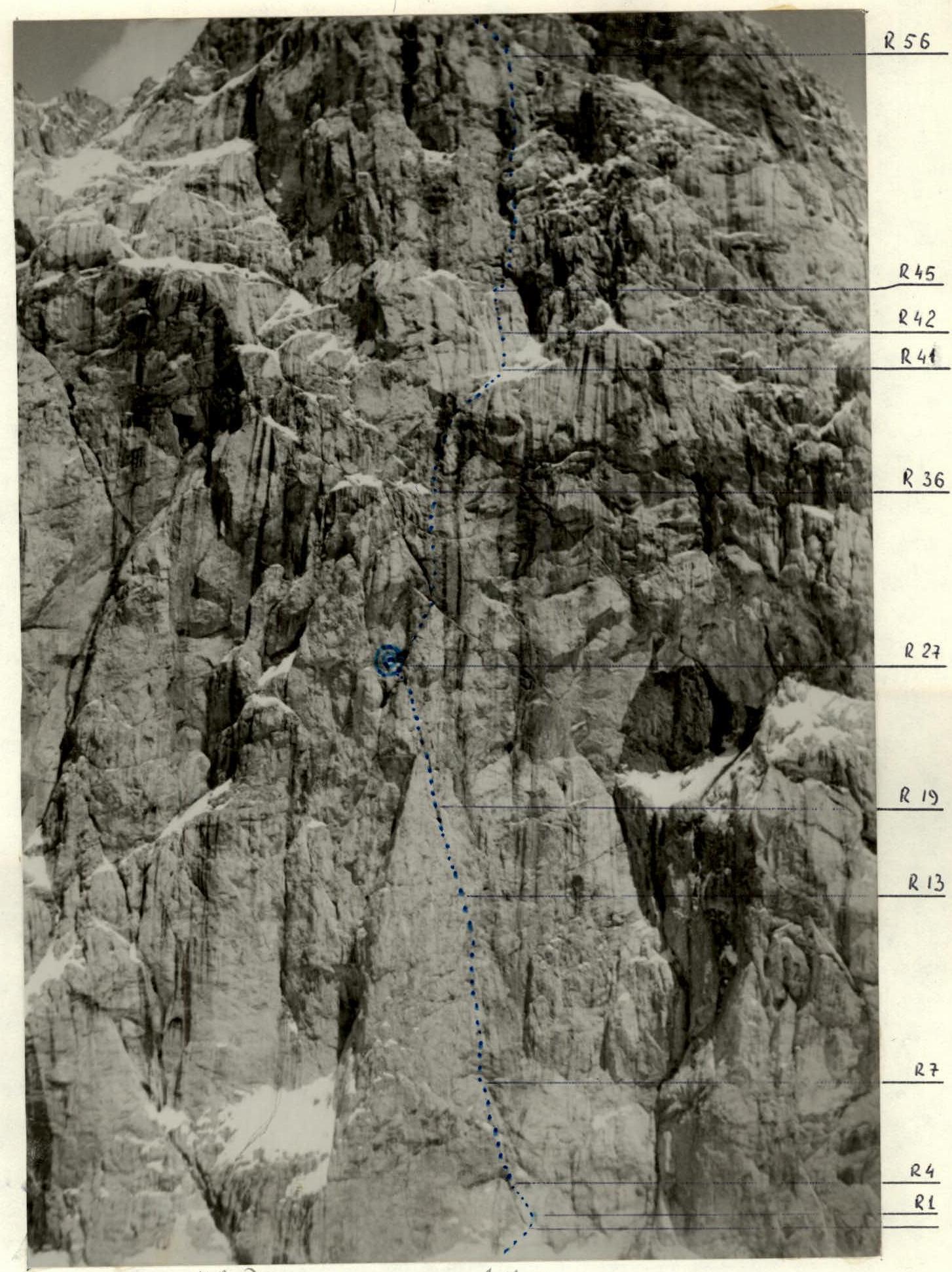
Photo #3. Technical photograph of the route. Lens type T-43. Shooting point #3 at an elevation of 4500 m. Date and time of shooting — July 22, 1987, 14:00. Distance to the object — 1000 m.