Ascent Passport
I. Ascent class: technical 2. Ascent area: Fann Mountains 3. Peak, its height and ascent route: Mt. Aurondagh, 4573 m, via the central part of the N wall 4. Proposed complexity category: 5B category 5. Route characteristics:
height difference — 1374 m, average steepness — 60°, length of sections:
- R1 — 300 m
- R2 — 150 m
- R4 — 370 m
- R5 — 435 m
- R6 — 40 m
- Number of pitons: for belaying, for creating
rock — 132, ice — 0, bolt — 0
- Number of climbing hours: 25.5 hours
- Number of nights and their characteristics:
2, bivouac
- Surname, name, patronymic of the leader and participants, their sports qualification
Samoylin V.A. leader, Candidate Master of Sports Povolotsky V.Yu. — Candidate Master of Sports Zadvoriev Yu.V. — Candidate Master of Sports Sitnikov N.N. — Candidate Master of Sports Oznobikhin B.A. — 1st sports category Lensky S.V. — 1st sports category
- Team coach: Master of Sports Mikhailov A.A.
- Date of departure and return: July 14 – July 16, 1978
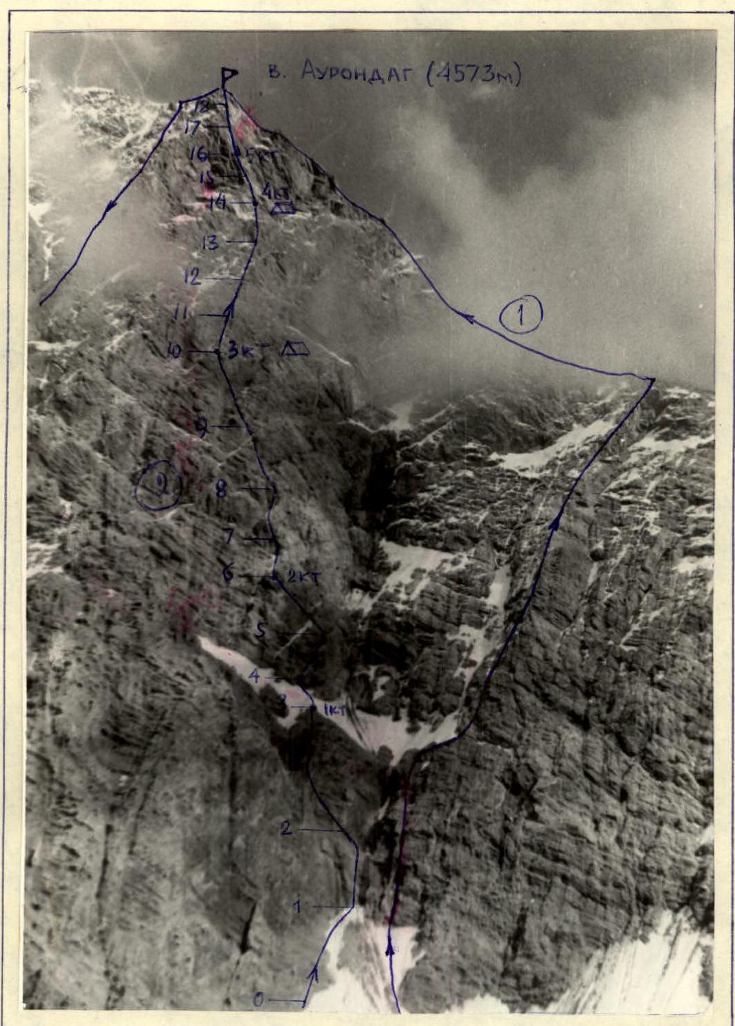
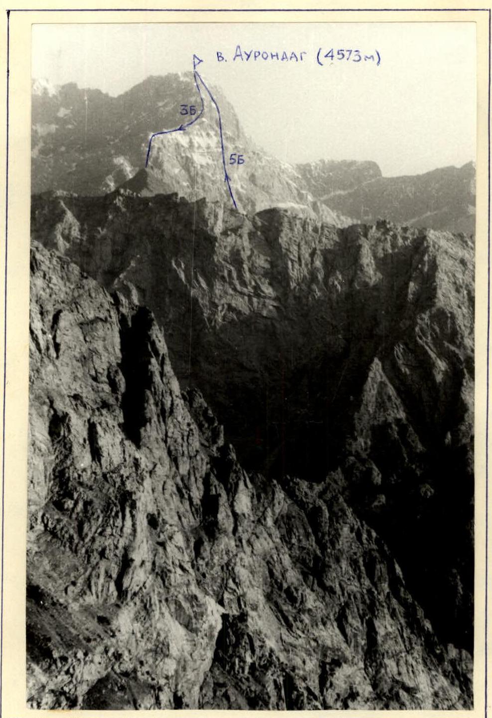
Mt. Aurondagh. 3rd ascent via T. Mumadji's route (2) with marked sections. (1) Previously climbed route, 5B category.
Mt. Aurondagh. Profile view.
Table of main route characteristics
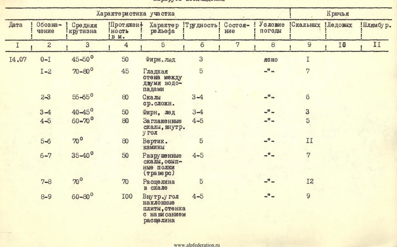
| Date | Designation | Average steepness | Length in m | Terrain characteristics | Difficulty | Condition | Weather conditions | Rock | Ice | Bolt |
|---|---|---|---|---|---|---|---|---|---|---|
| July 14 | R0–R1 | 45–50° | 50 | Firn, ice | 3 | Clear | 1 | |||
| R1–R2 | 70–80° | 45 | Smooth wall between two waterfalls | 5 | «-» | 7 | ||||
| R2–R3 | 55–65° | 80 | Medium complexity rocks | 3–4 | «-» | 6 | ||||
| R3–R4 | 40–45° | 50 | Firn, ice | 3–4 | «-» | 3 | ||||
| R4–R5 | 60–70° | 80 | Smoothed rocks, inner corner | 4–5 | «-» | 5 | ||||
| R5–R6 | 70° | 80 | Vertical chimneys | 5 | «-» | 11 | ||||
| R6–R7 | 35–40° | 50 | Broken rocks, talus shelves (traverse) | 4–5 | «-» | 7 | ||||
| R7–R8 | 70° | 70 | Crack in rock | 5 | «-» | 12 | ||||
| R8–R9 | 60–80° | 100 | Inner corner, sloping slabs, wall with | 4–5 | «-» | 9 | ||||
| overhang, crack | ||||||||||
| July 15 | R9–R10 | 45–55° | 120 | Rocks, shelves in wall, talus gully | 3 | Highly broken rocks | Clear | 9 | ||
| R10–R11 | 50–60° | 80 | Crack and slabs | 4 | Clear | 7 | ||||
| R11–R12 | 65° | 80 | Steep ridge | 4 | «-» | 5 | ||||
| R12–R13 | 70–80° | 90 | Sharp crest | 5 | Smoothed slabs in upper part | «-» | 13 | |||
| R13–R14 | 30–40° | 70 | Sloping talus shelves under bastion base | 3 | «-» | 2 | ||||
| R14–R15 | 60–65° | 80 | Sloping shelves; wall | 4 | Broken wall with exit to slab | «-» | 6 | |||
| R15–R16 | 75–85° | 40 | Rock wall | 6 | Smooth slab without holds, | «-» | 11 | |||
| quartz "lens" | ||||||||||
| R16–R17 | 70–80° | 80 | Inner corner with cornice, smooth wall, | 5 | «-» | 10 | ||||
| exit to shelf | ||||||||||
| R17–R18 | 60–70° | 40 | Inner corner, exit to bastion summit | 4 | «-» | 4 | ||||
| July 16 | R18–R19 | 20–30° | 300 | Broken ridge | 2 | Clear |

Team Captain V. Samoylin Team Coach A. Mikhailov
Description of the route and main characteristics
Section R0–R1. Steep firn leading to rocks between two waterfalls. Covered with ice crust in upper part. Climbed with alternating belay to the left of the left waterfall, then one rope of handline traverse to the right with step kicking. Section R1–R2. Up the smooth steep wall between two waterfalls. One rope of difficult climbing — vertically up with exit to the left onto a shelf, handline. Section R2–R3. Via the right part of the couloir descending from the saddle between Aurondagh and Zierat to the summit of the first bastion. Two ropes of rock with good holds, exit to bastion on the left — 1st control point. Sections R0–R3 were climbed with preliminary processing. Based on observations, the recommended time for climbing these sections, from the point of view of rockfall safety, is before 10:00. Section R3–R4. Left along a wide sloping shelf to the base of the second bastion — 50 m. Firn, ice. Alternating belay via ice axe, piton near rocks. Section R4–R5. Up and right along smoothed rocks and inner corner to the saddle near the start of chimneys. Difficult climbing with alternating belay, handline. Section R5–R6. Two vertical chimneys (one above the other), each 40 m. Piton belay and via ledges, handline. Section R6–R7. Right, along broken rocks and talus shelves. Alternating movement. Increased rockfall hazard! Section R7–R8. Up the steep crack and inner corner to the summit of the second bastion. Difficult climbing with piton belay, handline. Exit to small talus shelves (Lunch). Section R8–R9. Up the inner corner and crack to the left (zigzagging) through an overhang to the platforms (first ascenders' bivouac). Difficult rocks, alternating belay, handline on the section with cornices. Section R9–R10. Highly broken rocks, shelves in the wall, talus gully. Medium climbing, alternating belay. Increased rockfall hazard. Exit to shoulder to 3rd control point. Good shelves. 1st overnight stay. Section R10–R11. Right along a steep shelf around the corner of the wall and then left up along the crack and slabs (80 m). Medium complexity rocks, alternating movement. Section R11–R12. Up the steep ridge to the platforms (second ascenders' bivouac). Alternating belay. Section R12–R13. Left up along steep rocks and then via the left part of the ice couloir (steep crest, smoothed slabs). Difficult climbing, piton belay, handline. Section R13–R14. Along sloping talus shelves, exit to a platform under the base of the pre-summit bastion (first ascenders' bivouac). 4th control point. Alternating belay, increased rockfall hazard. Stop for overnight stay and further processing until exit to the summit of the pre-summit bastion (sections R14–R18). Section R14–R15. Along sloping shelves and broken wall to the right to smoothed slabs and then left under the steep overhanging section of the bastion. Alternating belay, preparation for processing the key section of the route. Section R15–R16. Smooth sheer wall without holds with a vertical crack, in the upper part overhanging "rusty" unstable blocks — "lens". Exit to a narrow shelf — 5th control point. Very difficult climbing using piton belay and ladders, organization of handline. Increased rockfall hazard for those below due to crumbling of the "lens" during its passage. Section R16–R17. Up the inner corner and then right through cornices with exit to smoothed slabs and a shelf under the base of the crack leading to the pre-summit ridge. Difficult climbing, alternating belay, handline. Section R17–R18. Right up along the crack and inner corner to the ridge and summit of the bastion. Alternating belay, handline. After processing sections R14–R18, descent to the overnight stay on a shelf near the 4th control point. Section R18–R19. After climbing via handline sections R14–R18, simultaneous movement along the broken ridge to the summit of Aurondagh. Descent from the summit to the saddle Aurondagh–Zierat via the 3B category route.