Ascent Passport
-
Ascent class – technical.
-
Ascent area – Fann Mountains, Zeravshan Range.
-
Peak, its height, ascent route – Mt. Aurandag, 4573 m, via the center of the northwest wall.
-
Proposed difficulty category – 5B.
-
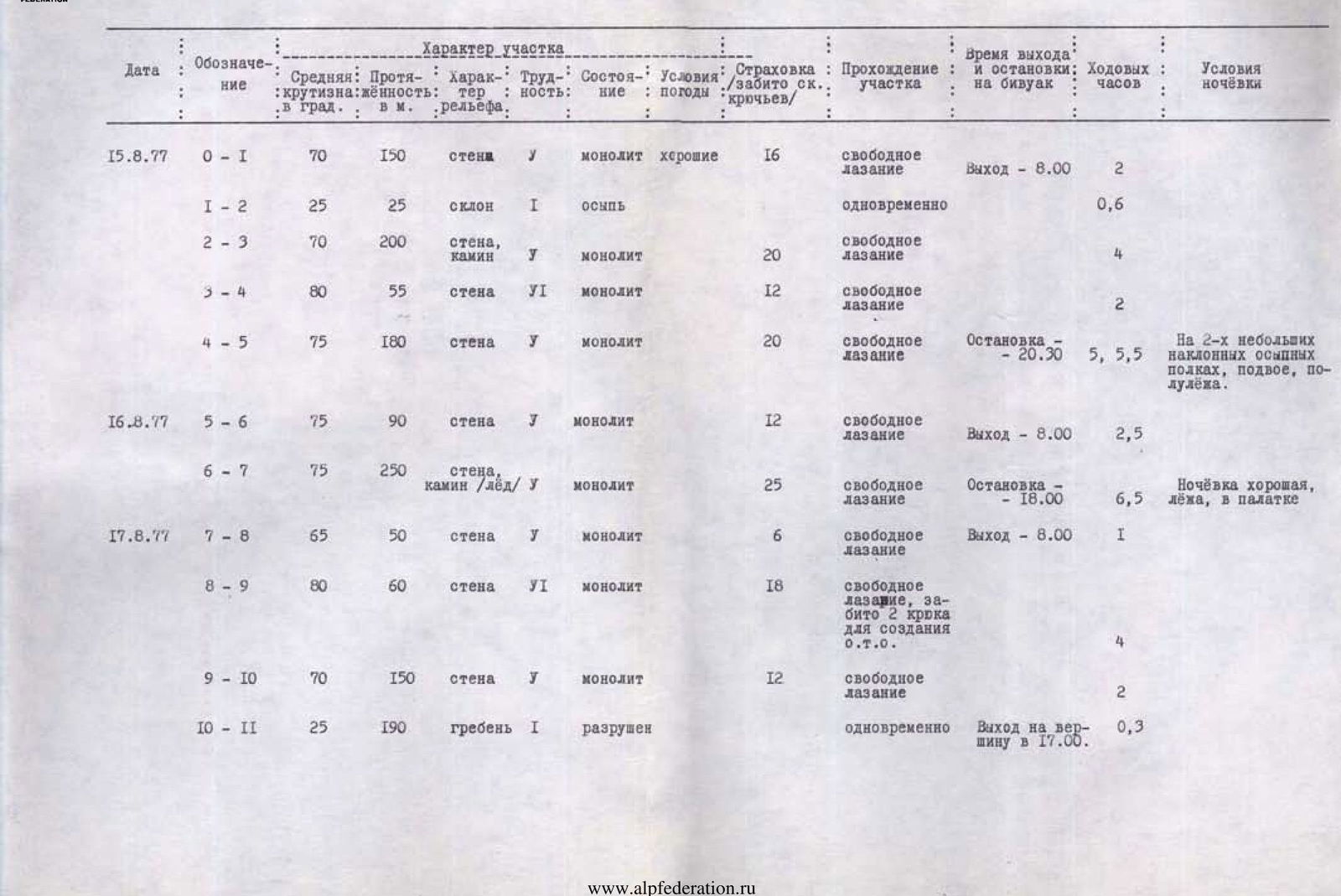
Route characteristics:
height difference – 1123 m, length of 5th-6th difficulty category sections – 1185 m, average steepness – 65°.
- Pitons driven (for belaying and creating artificial holds):
rock – 143, ice – — , bolt – — .
- Number of climbing hours – 30.
- Number of bivouacs and their characteristics:
1st bivouac – satisfactory (on scree shelves, half-lying, in pairs). 2nd bivouac – good (tent set up).
- Surname, initials of the leader, participants, and their qualifications:
Mumdzhi Timur Memetovich, Candidate Master of Sports – leader, Ponomarev Valery Alekseevich, Candidate Master of Sports – participant, Smirnov Gennady Konstantinovich, 1st sports category – participant, Gornostaev Vladimir Vasilyevich, 1st sports category – participant.
-
Initials of the team coach – Mumdzhi Timur Memetovich.
-
Date of departure and return:
departure – August 15, 1977 return – August 17, 1977
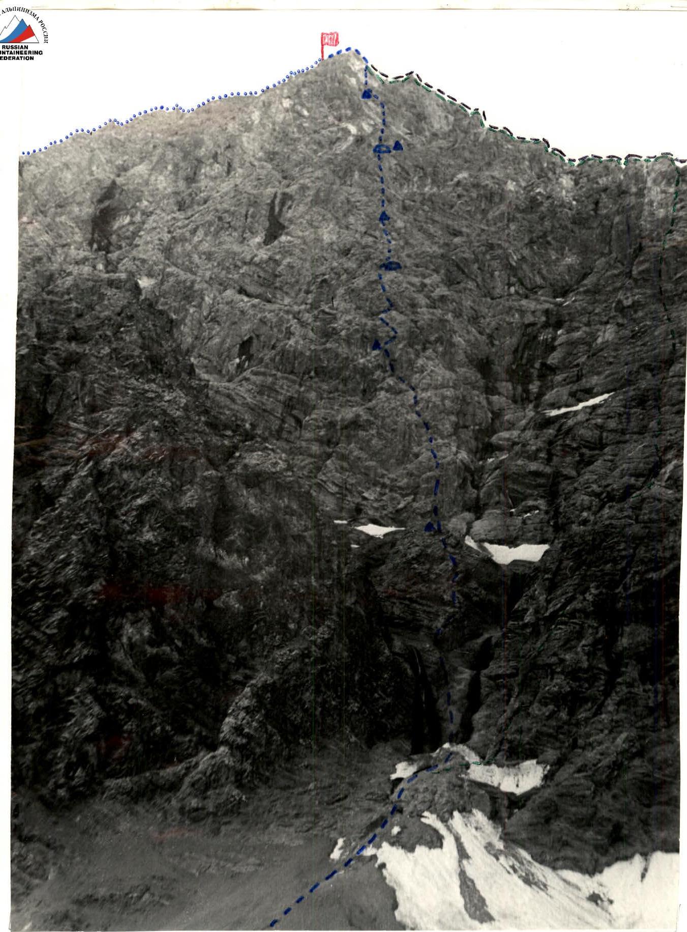
Mt. Aurandag
— route via the center of the northwest wall. — route via the northwest ridge of the western crest, 5B difficulty category. — route from Pereval MezhOzerny (via the western crest), 4B difficulty category. — route via the northern crest, 3B difficulty category.
Mt. Aurandag Route via the center of the northwest wall. Photo taken with a telephoto lens from the bivouac on the Aurandag glacier.
TABLE OF MAIN ROUTE CHARACTERISTICS
Brief explanations of the table
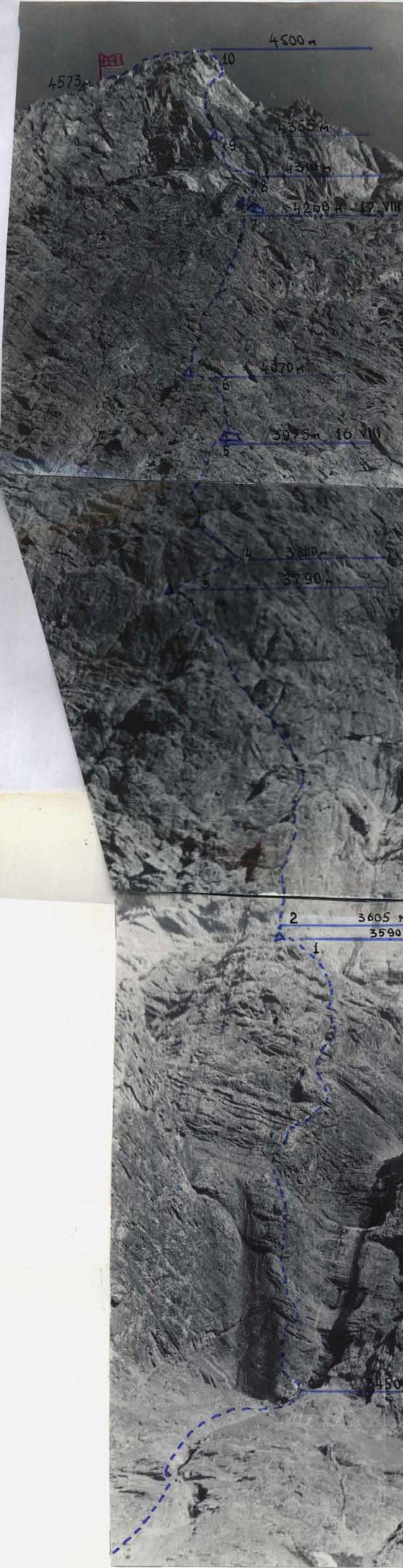
Section R0–R1
Up a steep monolithic rock wall between two waterfalls, vertically (70 m).
Then along an indistinct ridge to the top of the rock bastion (80 m), separated from the wall by a wide scree shelf.
The 1st control cairn is set up here.
Section R1–R2
Cross the scree shelf towards the base of the large rock triangle (25 m).
Section R2–R3
Vertically up, first along the right part of the rock triangle (70 m), then along its right face, which is a series of steep chimneys and cracks, to the top of the triangle (80 m), and another chimney (50 m) leads to a distinct "flake" in the wall.
Behind the "flake", on a small scree shelf, the 2nd control cairn is set up.
Section R3–R4
Straight through the "flake", using it for belaying, up (4 m), then traverse right along a steep monolithic wall to a cornice (15 m, very difficult!). Then under the cornice, and again traverse right along a series of narrow shelves to the base of a steep inclined crack (40 m). This traverse is called a "chameleon" due to its initially apparent relative simplicity.
Section R4–R5
Up the crack to the left (30 m) to the spot where backpacks are pulled up from the "flake". The pull-up was done along continuous overhanging rocks.
Then up the wall (40 m) to the base of a crack-chimney with a monolithic rock plug. The first person squeezes through the crack under the plug. The rest with backpacks have to overcome the plug from above using a ladder. Up the crack to the left (40 m), and again up a sheer inner corner (40 m) to a horizontal crack filled with ice inside and turning further into a small inclined shelf covered with scree in the middle.
The 1st bivouac is organized on the shelf. They spent the night half-lying in three different points on the shelf.
In total, about 600 m were covered during the day (in 13 hours 30 minutes of climbing time).
Section R5–R6
From the right end of the shelf, vertically up a crack with a cornice at the exit (40 m) to destroyed small shelves (more comfortable overnight stay possible – for four, half-lying). Then up the wall, then right, left (total 50 m) and exit onto a horizontal scree terrace (shoulder), protruding 8–10 m from the wall, where an excellent bivouac can be organized by setting up a tent.
The 3rd control cairn is set up here.
Section R6–R7
From the cairn, right along the shelf, then left up a large steep inner corner (80 m). Then vertically up the wall (50 m) to small inclined shelves. From here, the sheer pre-summit bastion is visible above, resembling a sail in shape.
Then up the wall to the left, to an inner corner, and vertically up it (60 m). Again, up the wall vertically (40 m) to the base of a steep ice gully. The first person goes over the top of the left wall of the gully, the rest – on the fixed rope along the gully (50 m). Then up steep slabs to scree inclined shelves, where the 2nd bivouac is organized (a platform is built, a tent is set up).
In total, about 350 m were covered during the day (in 9 climbing hours).
The 4th control cairn is also set up here.
Section R7–R8
Again up – first along steep slabs, then along a steep sheer wall, and again along slabs to a narrow horizontal shelf at the base of the pre-summit bastion (50 m).
Section R8–R9
Left along the shelf along the base of a sheer smooth light pink slab to a vertical crack (10–12 m), running parallel to the left edge of the pre-summit bastion.
Up the crack (very difficult, ladders are used) to overhanging cornices (30 m) and traverse right-up along the smooth slab with individual footholds to a small inclined platform at the base of a sheer 10-meter wall of dark gray color (8–10 m).
From the platform, vertically up through a calcite lens (a piton with a ladder is driven from the shoulder) to an inclined about 1 m wide shelf (6 m).
Along the shelf, 10 m to the left, to the spot where backpacks are pulled up from the base of the slab.
The 5th control cairn with a tin indicator made from a can is also set up here.
Climbing in this section is very technically and psychologically difficult. The use of bolt pitons is recommended for passing this section.
Section R9–R10
From the cairn, vertically up a crack, crossing a calcite vein, to an inner corner (20 m).
Then:
- up to the right onto the roof of a dark reddish cornice (very difficult!)
- then along the wall under the cornices of the roof of the pre-summit bastion (30 m)
- then traverse right into a small scree depression, and from it vertically up to the right edge of the pre-summit bastion (50 m)
- along the edge, 50 m of moderately difficult rock to the exit onto the pre-summit.
Section R10–R11
Along the crest simultaneously to the summit of Mt. Aurandag. In total, on the 3rd day (in 7 climbing hours), about 200 m of the wall section of the route were covered.
The descent was made along the northern crest to Lake Kuli-Kalon.