Climbing Ascent Document
-
Climbing category: technical
-
Climbing area: Pamir-Alay (Fan Mountains)
-
Peak, its height, ascent route: peak Aurondag 4573 m via the northeast wall.
-
Estimated difficulty category — 5B
-
Route characteristics: height difference — 980 m
average steepness — 73°, length of sections: 1st cat. diff. — —, 2nd cat. diff. — —, 3rd cat. diff. — 45, 4th cat. diff. — 340, 5th cat. diff. — 516, 6th cat. diff. — 139 m.
-
Number of pitons driven:
for belaying: special — 164, wooden wedges — 5 for creating artificial holds — 11
-
Number of hours to complete the ascent — 17–18 hours.
-
Number of bivouacs and their characteristics:
Both bivouacs on the wall are identical — narrow platforms for a 3–4 person tent. The platforms are bounded by sheer walls. There is a possibility to organize belaying. A bolted piton is driven on the first control point. There is no water. The bivouac on the ridge is sheltered from the wind, with ice nearby.
-
Name of the team leader and participants, their sports qualification:
Vikulov Alim Iskhakovich CMS Rybakov Alexander Vasilyevich CMS Senetsky Vitaly Petrovich CMS Nikolaenko Alexander Pavlovich 1st sports category Leitsinger Vladimir Andreyevich 1st sports category
-
Team coach: Kosaty Viktor Trofimovich.
-
Date of departure and return: August 7 — August 10, 1977
General view of Aurondag
General view of the route on peak Aurondag, approximately 5B category.
TABLE
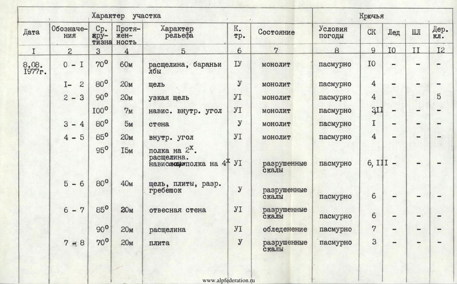
| Date | Designation | Average steepness | Length | Terrain characteristics | Category of difficulty | Condition | Weather conditions | Safety lines | Ice | Bolted pitons | Wooden wedges |
|---|---|---|---|---|---|---|---|---|---|---|---|
| August 8 | R0–R1 | 70° | 60 m | crevice, "ram's foreheads" | 4 | monolithic | overcast | 10 | – | – | – |
| 1977 | R1–R2 | 80° | 20 m | gap | 1 | monolithic | overcast | 4 | – | – | – |
| R2–R3 | 90° | 20 m | narrow gap | 6 | monolithic | overcast | 4 | – | – | 5 | |
| 100° | 7 m | overhanging inner corner | 6 | monolithic | overcast | 3 | – | – | – | ||
| R3–R4 | 80° | 5 m | wall | 1 | monolithic | overcast | 1 | – | – | – | |
| R4–R5 | 85° | 20 m | inner corner | 6 | monolithic | overcast | 4 | – | – | – | |
| 95° | 15 m | ledge on 2X. crevice. overhanging ledge on 4 | 6 | destroyed rocks | overcast | 6 | – | – | – | ||
| R5–R6 | 80° | 40 m | gap, slabs, destroyed ridge | 1 | destroyed rocks | overcast | 6 | – | – | – | |
| R6–R7 | 85° | 20 m | sheer wall | 6 | destroyed rocks | overcast | 6 | – | – | – | |
| 90° | 20 m | crevice | 6 | icing | overcast | 7 | – | – | – | ||
| R7–R8 | 70° | 20 m | slab | 1 | destroyed rocks | overcast | 3 | – | – | – | |
| R8–R9 | 80° | 15 m | wall | 1 | destroyed rocks | overcast | 4 | – | – | – | |
| R9–R10 | 70° | 40 m | slab | 4 | monolithic | overcast | 3 | – | – | – | |
| R10–R11 | 70° | 40 m | slabs | 1 | destroyed rocks | overcast | 5 | – | – | – | |
| R11–R12 | 80° | 60 m | inner corner | 1 | destroyed rocks | overcast | 10 | – | – | – | |
| R12–R13 | 65° | 60 m | ridge | 4 | destroyed rocks | overcast | 4 | – | – | – | |
| R13–R14 | 60° | 40 m | ledges | 3 | destroyed rocks | overcast | 5 | – | – | – | |
| 85° | 8 m | wall | 1 | monolithic | overcast | 4 | – | – | – | ||
| 0° | 5 m | ledge on 2X | 3 | destroyed rocks | overcast | 2 | – | – | – | ||
| 85° | 8 m | wall | 1 | monolithic | overcast | 4 | – | – | – | ||
| 60° | 40 m | inclined ledges | 4 | destroyed rocks | overcast | 6 | – | – | – | ||
| R14–R15 | 65° | 40 m | ridge | 4 | destroyed rocks | overcast | 3 | – | – | – | |
| R15–R16 | 75° | 20 m | wall | 1 | monolithic | overcast | 5 | – | – | – | |
| R16–R17 | 55° | 60 m | ridge, ledge on 4X | 4 | destroyed rocks, ledges | overcast | – | – | – | – | |
| Exit to the route — 8:00. Stopped at the bivouac at 16:00. 8 hours of climbing. | |||||||||||
| Bivouac conditions: small platform, difficult accommodation, organization of a belay rope. The platform is bounded by sheer drops. No water. Strong cold wind. | |||||||||||
| August 9 | R17–R18 | 75° | 80 m | short, steep walls | 1 | destroyed rocks | clear, strong wind | 10 | – | – | – |
| 1977 | R18–R19 | 45° | 40 m | gap, oblique ledge | 4 | destroyed rocks | – " – | 2 | – | – | – |
| R19–R20 | 80° | 40 m | yellow wall | 1 | monolithic | – " – | 7 | – | – | – | |
| R20–R21 | 65° | 15 m | ridge | 1 | destroyed rocks | – " – | 3 | – | – | – | |
| 70° | 40 m | icy gully | 1 | icy rocks | – " – | 6 | – | – | – | ||
| R21–R22 | 95° | 7 m | chip, live plug | 6 | monolithic | – " – | 2 | – | – | – | |
| 80° | 15 m | inner corner | 6 | destroyed rocks | – " – | 4 | – | – | – | ||
| R22–R23 | 75° | 30 m | traverse, "ram's foreheads", short wall | 1 | monolithic | – " – | 4 | – | – | – | |
| 80° | 10 m | inner corner | 1 | icy destroyed rocks | – " – | 2 | – | – | – | ||
| R23–R24 | 90° | 15 m | wall | 6 | monolithic | – " – | 5 | – | – | – | |
| 90° | 15 m | chimney | 1 | monolithic | – " – | 4 | – | – | – | ||
| 85° | 15 m | wall | 1 | monolithic | – " – | 2 | – | – | – | ||
| R24–R25 | 80° | 30 m | "ram's foreheads", ridge | 1 | monolithic | clear, gusty wind | 4 | ||||
| Exit to the route — 8:00. Stopped at the bivouac at 17:00. 9 hours of climbing. | |||||||||||
| Bivouac conditions: convenient safe platform, sheltered from the wind, ice nearby. |
Explanation for the table
Description of the route on peak Aurondag via the northeast wall, approximately 5B category. Second ascent.
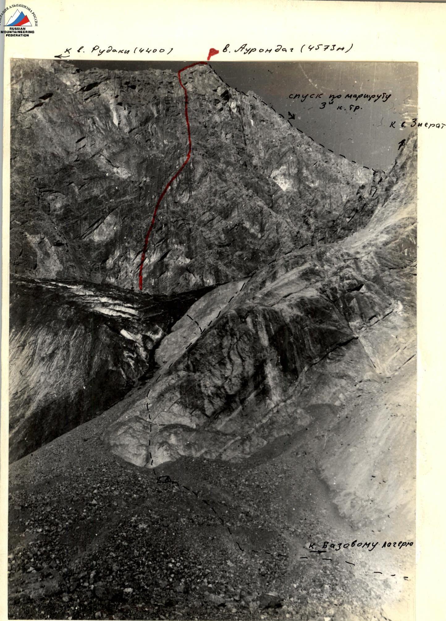
Exit from the base camp on "Bibi-Djanat" lake. Go around "B. Kulikalon" lake from the left, ascend via scree into the cirque of peaks Maria, Rudaki, Aurondag, Zierat, and follow the right side — approach under the "ram's foreheads". Bivouac site.
From the bivouac via "ram's foreheads" 80 m (50–60°) exit to the glacier. The route begins 60 m to the right of the "black stream" at the base of a wide inner corner of the northeast wall of peak Aurondag.
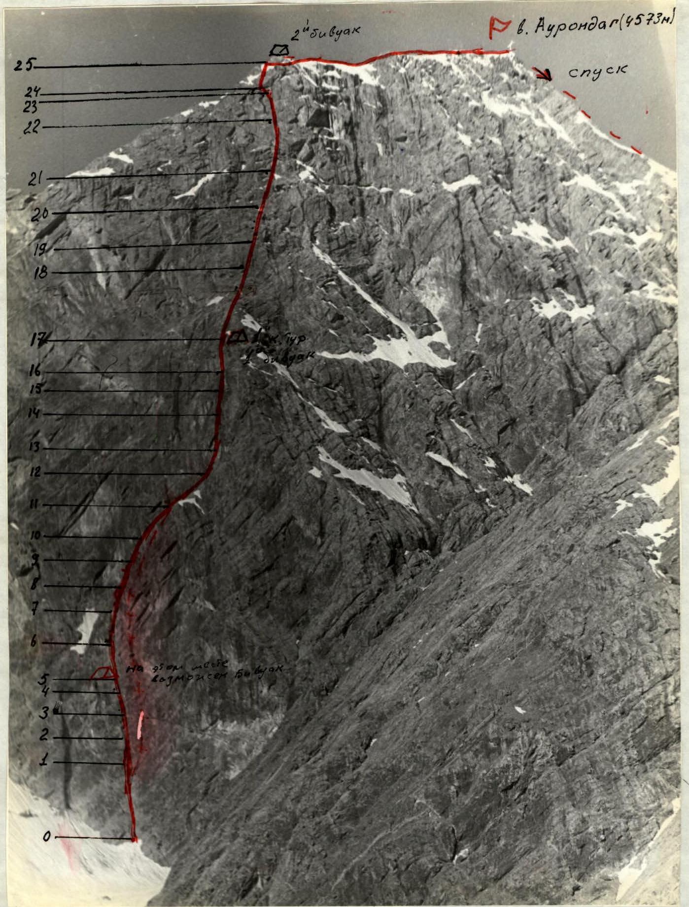
Section R0–R1
Via a narrow crevice and further via rocks of medium difficulty — like "ram's foreheads" 60 m (70°). Few places for driving pitons. To the left is rockfall hazard.
Section R1–R2
Further via a very steep wall (80°) 20 m to a narrow vertical gap. Difficult climbing, few places for organizing belay points, rocks are "polished".
Section R2–R3
Via a narrow gap of the inner corner (like an "open book") upwards 20 m (90°). Difficult climbing, use of wooden wedges and placements. Exit through the overhanging part of the inner corner 95–100° — 7 m. Climbing is very complex, use of artificial holds.
Section R3–R4
Exit to the left side from the inner corner 5 m (80°) and further again into the inner corner up to the overhanging cornice 20 m (85°). Very complex climbing.
Section R4–R5
Exit under the cornice and further left onto a ledge. From the ledge via a crevice, overhanging from the top, to a wide ledge. 15 m (90–95°).
There is a safe place for a bivouac.
Section R5–R6
From the platform to the right and upwards via destroyed rocks. Upwards via an oblique gap and further left upwards via destroyed slabs to a small ridge, sharply dropping down to the left into the direction of the black huge gully 40 m (80°).
Section R6–R7
From the ridge to the right upwards under the sheer wall (85°) 20 m. Via the wall to the left upwards to a large crevice with ice accretion. 20 m (90°) — very complex climbing.
Section R7–R8
Further to the right upwards via a slab to the ridge 20 m (70°) and to the left upwards via a short wall, exit under a slab 15 m (80°).
Section R8–R9
Via the slab to the right upwards 40 m (70°). Climbing of medium difficulty.
Section R9–R10
Further to the right upwards, crossing destroyed slabs 40 m (70°) (complex climbing), under the inner corner.
Section R10–R11
Via an inclined inner corner exit onto a rib 60 m (80°). Climbing is difficult.
Section R11–R12
Via the rib upwards to a shoulder 60 m (65°). Few places for driving pitons. Climbing of medium difficulty.
Section R12–R13
Via the shoulder to the right upwards via ledges 40 m to a chimney with a plug (60°). Climbing of medium difficulty.
Section R13–R14
Bypass the chimney with a plug via a wall 8 m (85°) to the left upwards under the next wall. Further via a ledge to the left 5 m and via a steep wall 8 m (85°), exit onto steep inclined ledges to the ridge of the counterfort 40 m (60°).
Section R14–R15
Via the ridge of the counterfort 40 m (65°). Medium climbing under a wet wall.
Section R15–R16
Via the wall upwards 20 m (75°). Climbing is complex.
Section R16–R17
Further via heavily destroyed rocks (climbing is medium, 60 m (50–55°)) exit under the wall. Bivouac site and control point.
Section R17–R18
From the platform via short steep walls of 3–4 m (85–90°), exit upwards to a small ledge 80 m (60°). Average steepness of the section — 75°.
Section R18–R19
From the ledge to the right upwards along a gap, and then to the left via an oblique ledge with snow 40 m (45°).
Section R19–R20
From here upwards through heavily destroyed overhanging yellow walls 40 m (80°). Complex climbing.
Section R20–R21
Further to the left (15 m (65°), rocks of medium difficulty) and upwards via a destroyed gully with ice accretion under an overhanging yellow wall 40 m (70°). Few places for organizing intermediate belay.
Section R21–R22
Via a chip to the left to the right upwards under an overhang (artificial holds), which is passed on the right side 7 m (95°). Through an overhanging live plug (dangerous) via a steep inner corner 15 m (80°) under a rusty wall with water flows (on ledges in the second half of the season — ice!).
Section R22–R23
Under the rusty overhanging wall-shelf. From here traverse to the left upwards via a steep wall like "ram's foreheads". Complex climbing, few places for organizing intermediate belay (live rocks in the upper part!). 30 m (75°). Then via an inner corner 10 m (80°) (ice accretion) in the upper part destroyed, exit onto a "balcony".
Section R23–R24
From the "balcony" upwards via a sheer wall 15 m (90°) with short overhanging sections and further via a steep chimney 15 m (90°) (ice accretion), ending with a wall 15 m (85°). Few holds. Live rocks in the upper part of the wall (dangerous). Climbing is complex.
Section R24–R25
Via steep, but short walls, like "ram's foreheads", exit onto the pre-summit ridge 30 m (80°) — climbing is complex.
Bivouac site. There is ice for water. Via the ridge (simple rocks) exit onto the summit of Aurondag 4573 m. Descent via the 3B category route. To "Bibi-Djanat" lake — 4–5 hours.
General conclusion on the route
The route via the northeast wall of peak Aurondag is an interesting and logical route. The route is long and requires participants to be in good physical condition. The steepness of key sections is 90–100°. Technically, the route is complex, requiring careful selection of equipment, mastery of advanced rock climbing techniques, and tactics of modern ascents. The route is climbed in rubber boots. Strictly follow the counterfort; to the left and right — rockfall hazard. Ice accretion is encountered.
It is recommended to climb the route in the second half of the season.
Bivouac sites are available on the route according to the description.
There is no water on the second control point.
For organizing belaying and self-belaying, 164 rock pitons and 5 wooden wedges were driven.
For organizing artificial holds — 18 rock pitons.
Rappel was used in two places.
Based on the experience of modern ascents of 5B–6B category on the Caucasus and in the Fan Mountains, the team members consider the route on peak Aurondag via the northeast wall to correspond to the 5B category.
Ascent experience of team members: 5B–6B category.
Caucasus:
- Traverse of Pikeldy
- Dalar via the north ridge
- Dalar via the west wall
- Double peak via the "edge"
- Brick peak via the south wall
Fan Mountains:
- Bodkhona via the west wall (Kolchin's route)
- Rudaki via the left counterfort
- Chapdara via the "Sphinx"
Route ascent
1st day. August 7, 1977
The group left the base camp on "Bibi-Djanat" lake at 12:00 and, going around "B. Kulikalon" lake from the left, approached under the north wall of peak Maria. Then, turning left, at 14:20 they approached under the "ram's foreheads". Two people — Rybakov and Leitsinger — stayed to organize the bivouac, and three — Vikulov, Senetsky, and Nikolaenko — left at 15:00 under the route for observation and to throw necessary equipment for the ascent. This day, the trio returned to the bivouac at 20:30. Everyone went to bed at 21:30.
On the first day, they deliberately refused preliminary processing and decided to study the route better (the group had a 20x tube) and track the paths of falling rocks.
2nd day. August 8, 1977
They left at 6:40 and, passing the "ram's foreheads" and the snow plateau, approached under the northeast wall of peak Aurondag at 8:10. The route begins to the right of the "Black stream", at the base of a wide inner corner.
The rope team Vikulov — Leitsinger started moving first, and then was replaced by the rope team Rybakov — Senetsky — Nikolaenko. Moving alternately, the rope teams replaced each other every 80–120 m. Since the route is new and there is little data on it, the group had to be especially careful in choosing the path and monitoring rocks. All sections up to the first control point are characterized by great steepness and a small number of holds, and the rocks are "polished" in many places. Despite all this, the group passed this part of the route at a good pace, observing all safety rules. They stopped at the 1st control point at 16:20. Vikulov, Senetsky, and Leitsinger set up the tent and prepared food, while the rope team Rybakov — Nikolaenko went for processing. On this day, they covered 675 m and processed 80 m of the route. On section R6–R7, they organized a rappel. The retreat was made at 21:00.
3rd day. August 9, 1977
They left the bivouac at 7:00 and quickly passed the ropes processed the day before. The movement was led by the rope team Leitsinger — Rybakov. There were no big technical difficulties on this section. From the bivouac, the route goes straight up under the "rusty triangular" wall. The first 40 m after the processed ropes were relatively simple, but the presence of snow and ice accretion on the ledges required great caution.
Then again, there are steep and complex rocks, which are first passed by the rope team Senetsky — Nikolaenko. Having passed this section, the group comes to the base of a steep gully that rests against the "rusty triangular" wall. There are many live rocks in the gully, and ice accretion. Movement was carried out by moving from one side of the gully to the other. There were many short, 3–4 m, but very steep walls. On section R21–R22, they had to use artificial holds and rappel — this is the most complex place of the day. From under the "rusty triangular" wall, they traversed to the left via a steep slab with ice accretion and came out onto a "balcony". From here, the movement is again straight up. Via steep, in some places overhanging, walls and then a steep gully and wall with live rocks, the group came out onto the shoulder of the summit ridge at 18:00. A bivouac was organized here. For the day, they covered 352 m.
4th day. August 10, 1977
On this day, the group left for the route at 6:00 and, having passed the несложный summit ridge, was on the summit at 8:15.
The descent from the summit was carried out via the 3B category route. At 10:30, the group was at the bivouac under the "ram's foreheads" and then continued the descent to the base camp.
Thus, the tactical plan of the ascent was fully implemented.
Table of route characteristics on peak Aurondag via the center of the NE wall, approximately 5B category.
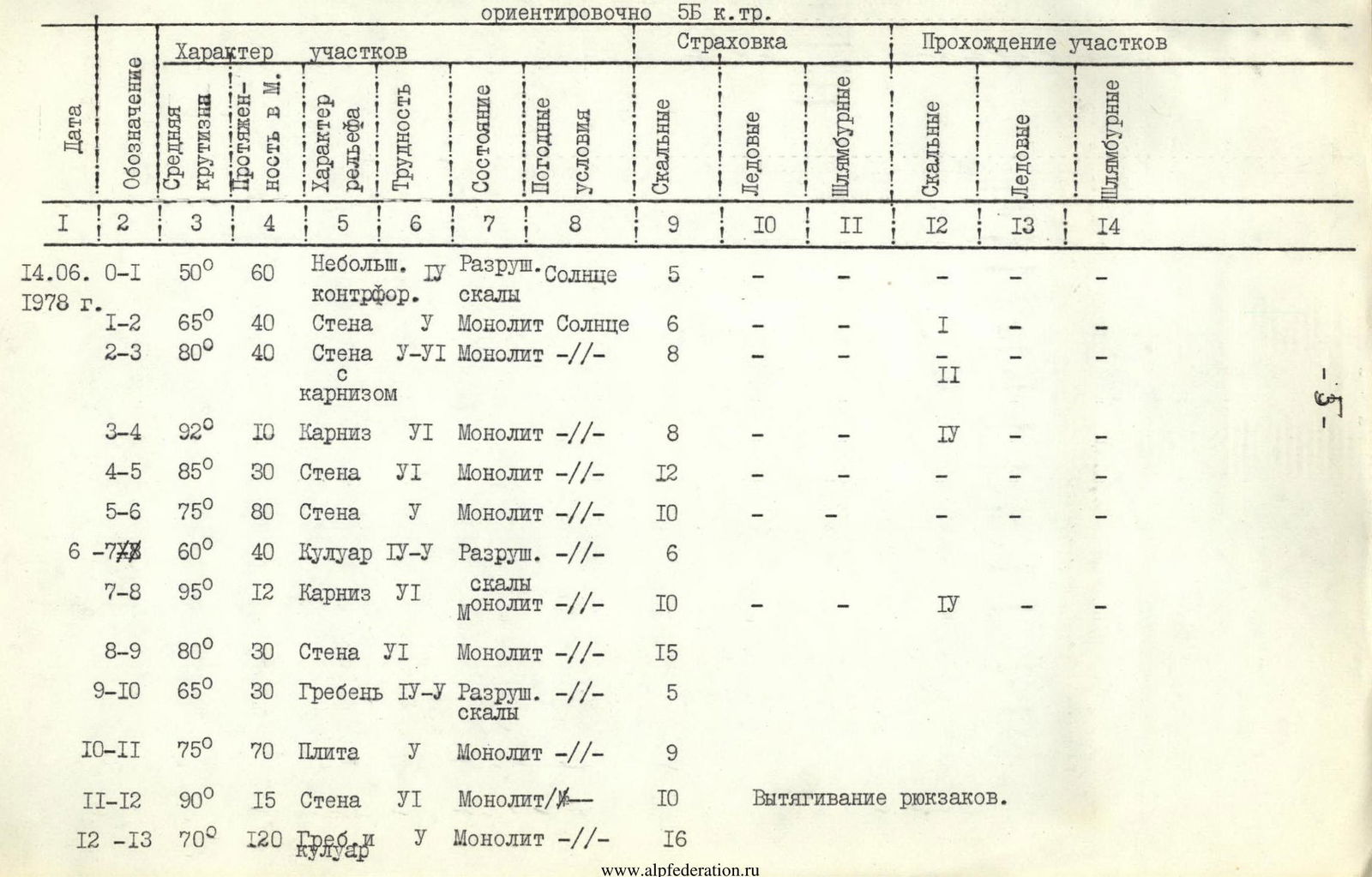

| Date | Designation | Average steepness | Length in m | Terrain characteristics | Difficulty | Condition | Weather | Safety lines | Ice | Bolted pitons | Rock pitons | Ice pitons |
|---|---|---|---|---|---|---|---|---|---|---|---|---|
| June 14 | R0–R1 | 50° | 60 | Small counterfort | 4 | Destroyed, sunny rocks | – | 5 | – | – | – | – |
| 1978 | R1–R2 | 65° | 40 | Wall | 1 | Monolithic, sun | – | 6 | – | – | 1 | – |
| R2–R3 | 80° | 40 | Wall with a cornice | 6 | Monolithic | – | 8 | – | – | 2 | – | |
| R3–R4 | 92° | 10 | Cornice | 6 | Monolithic | – | 8 | – | – | 4 | – | |
| R4–R5 | 85° | 30 | Wall | 6 | Monolithic | – | 12 | – | – | – | – | |
| R5–R6 | 75° | 80 | Wall | 1 | Monolithic | – | 10 | – | – | – | – | |
| R6–R7 | 60° | 40 | Gully | 4 | Destroyed rocks | – | 6 | – | – | – | – | |
| R7–R8 | 95° | 12 | Cornice | 6 | Monolithic | – | 10 | – | – | 4 | – | |
| R8–R9 | 80° | 30 | Wall | 6 | Monolithic | – | 15 | – | – | – | – | |
| R9–R10 | 65° | 30 | Ridge | 4 | Destroyed rocks | – | 5 | – | – | – | – | |
| R10–R11 | 75° | 70 | Slab | 1 | Monolithic | – | 9 | – | – | – | – | |
| R11–R12 | 90° | 15 | Wall | 6 | Monolithic | – | 10 | – | – | – | – | |
| Rappel | ||||||||||||
| R12–R13 | 70° | 120 | Ridge and gully | 1 | Monolithic | – | 16 | – | – | – | – | |
| Exit to the route 7:30. Stopped at the bivouac 19:30. Number of climbing hours — 12 hours. Bivouac on a snowy platform. Control point #1 on section R6–R7. | ||||||||||||
| June 15 | R13–R14 | 80° | 50 | Chimney with a plug | 6 | Monolithic | Cloudy, | 10 | – | – | 2 | – |
| 1978 | R14–R15 | 60° | 40 | Ridge and inner corner | 1 | Destroyed rocks | Cloudy, | 7 | – | – | – | – |
| R15–R16 | 85° | 40 | Wall | 4 | Destroyed rocks | Wind, snow grains | 15 | 3 | – | – | – | |
| R16–R17 | 70° | 70 | Gully | 4 | Icy rocks | Wind, snow | 7 | – | – | – | – | |
| Exit to the route 8:00. Stopped at the bivouac 17:00. Number of climbing hours — 9 hours. Bivouac on a snowy ridge. | ||||||||||||
| June 16 | R17–R18 | 55° | 70 | Snow-ice ridge | 4 | Destroyed and icy rocks | Cloudy | 4 | 4 | – | – | – |
| 1978 | R18–R19 | 75° | 80 | Wall | 1 | Monolithic | Fog, cloudy | 2 | – | – | – | – |
| R19–R20 | 85° | 80 | Gully | 6 | Destroyed rocks | Rain with snow | 16 | – | – | – | – | |
| Rappel | ||||||||||||
| Exit to the route 7:30. Stopped at the bivouac 15:30. Number of climbing hours — 7 hours 00 minutes. Sitting bivouac at the end of the gully under a large cornice. Control point #2. | ||||||||||||
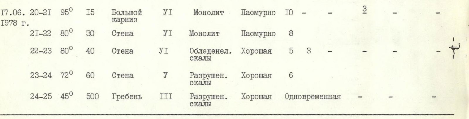
| June 17 | R20–R21 | 95° | 15 | Big cornice | 6 | Monolithic | Cloudy | 10 | – | – | 3 | – |
| 1978 | R21–R22 | 80° | 30 | Wall | 6 | Monolithic | Cloudy | 8 | – | – | – | – |
| R22–R23 | 80° | 40 | Wall | 6 | Icy rocks | Good | 5 | 3 | – | – | – | |
| R23–R24 | 72° | 60 | Wall | 1 | Destroyed rocks | Good | 6 | – | – | – | – | |
| R24–R25 | 45° | 50 | Ridge | 3 | Destroyed rocks | Good | – | – | – | – | – |
Exit to the route — 7:30. On the summit at 14:00. Descent to the bivouac on the moraine at 19:00. Number of climbing hours — 11 hours 30 minutes.
Total pitons driven on the route: 219 (rock), 10 (ice), 16 (artificial holds).
Team captain MVO: (Efremov N.L.)

Explanation for the table
Description of the route on peak Aurondag via the center of the NE wall, approximately 5B category.
June 13, 1978. Exit from the gathering camp of the USSR Armed Forces, located a little below the Kulikalon lakes, and approach under the peak took 3 hours 30 minutes. Bivouac site.
June 14, 1978. Exit from the bivouac site on the moraine at 6:00. Via the glacier to the NE wall of peak Aurondag 1 hour 30 minutes. The wall rises with a huge black triangle, the route passes through the center of the "triangle". A small counterfort protruding in the lower part of the wall is the beginning of the route. Via it 40 m of rocks of medium difficulty (section R0–R1), further to the right upwards one rope of difficult climbing (section R1–R2) with a small number of cracks. Via the wall to the right upwards along the edge of the overhanging section and to the left via an inclined ledge, bypassing the cornice on the right, exit under the 2nd big cornice (section R2–R3) 40 m of complex climbing. From under the cornice to the left downwards, further straight up and to the right onto an inclined ledge (section R3–R5), one rope. Total 160 m covered.
From here begins the section of big cornices. From the inclined ledge to the left upwards to the right edge of the big gully and via its edge under the big red cornice. Here is the 1st control point. 280 m covered (section R6–R7). Bypassing the cornice on the right via an overhanging wall (section R7–R8), exit to the left upwards and exit onto the ridge (section R9–R10) of the big gully to the left of the second big rusty cornice 50 m. Upwards via the ridge onto a huge gray slab going to the right upwards. Via the slab to the ridge of the slab (section R10–R11), complex climbing 70 m. From the ridge straight up via a vertical wall and a small overhang 15 m, rappel. From here to the left upwards under the wall in the direction of a snowy ridge 60 m and further to the right upwards 50 m via a gap and 10 m to the left via a steep gully (section R12–R13), to the bivouac site, onto a small snowy platform.
June 15, 1978. From the bivouac site at 8:00. Straight up 50 m (section R13–R14) to the beginning of a chimney with a live plug in its upper part, few places for driving pitons. Further up, via a poorly expressed ridge 40 m under an inner corner (section R14–R15). Via an overhanging corner with the use of artificial holds, very difficult climbing, approach under a wall to the left via a ledge. The wall