
| 1. Class of ascent: | technical. |
|---|---|
| 2. Ascent area: | Pamir-Alai (Fann Mountains) |
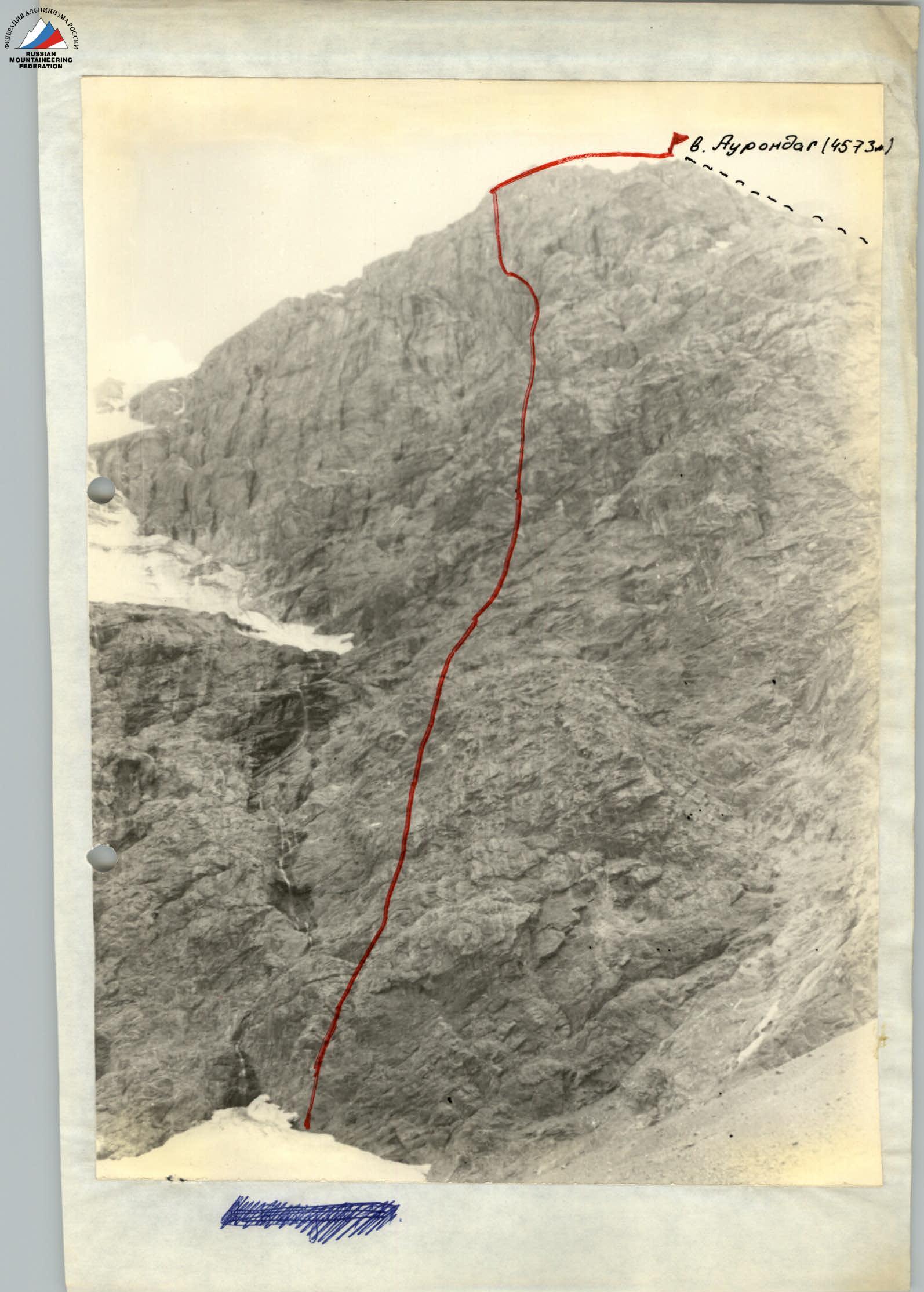
| 3. Peak, its height, ascent route: | p. Aurondag 4573 m via north-eastern wall. |
| 4. Estimated difficulty category: | 5B |
| 5. Route characteristics: | height difference — 980 m |
| average steepness — 73° | |
| section lengths: | |
| 1c.tr. — —, Pc.tr. — —, Шc.tr. — 45, 1Уc.tr. — 340, Уc.tr. — 510 | |
| У1c.tr. — 139 m: | |
| 6. Pitons driven: | for belaying |
| special: | — 164 |
| wooden wedges: | — 5 |
| for creating artificial holds: 11 | |
| 7. Number of climbing hours: | 17–18 h |
| 8. Number of bivouacs and their characteristics: | |
| Both bivouacs on the wall are identical — narrow platforms for a 3–4 person tent. The platforms are bounded by sheer walls. There is a possibility of organizing belaying. On the second category section, there is a piton. No water. The ridge bivouac is sheltered from the wind, with ice nearby. | |
| 9. Full name of team leader and participants, their sports qualification: | |
| Vikulov Alim Iskhakovich | Candidate Master of Sports |
| Rybakov Alexander Vasilyevich | Candidate Master of Sports |
| Seshenetsky Vitaly Petrovich | Candidate Master of Sports |
| Nikolaenko Alexander Pavlovich | 1st sports category |
| Leitsinger Vladimir Andreevich | 1st sports category |
| 10. Team coach: Kosaty Viktor Trafimovich. | |
| 11. Date of departure and return: | August 7 – August 10, 1977 |
Route description
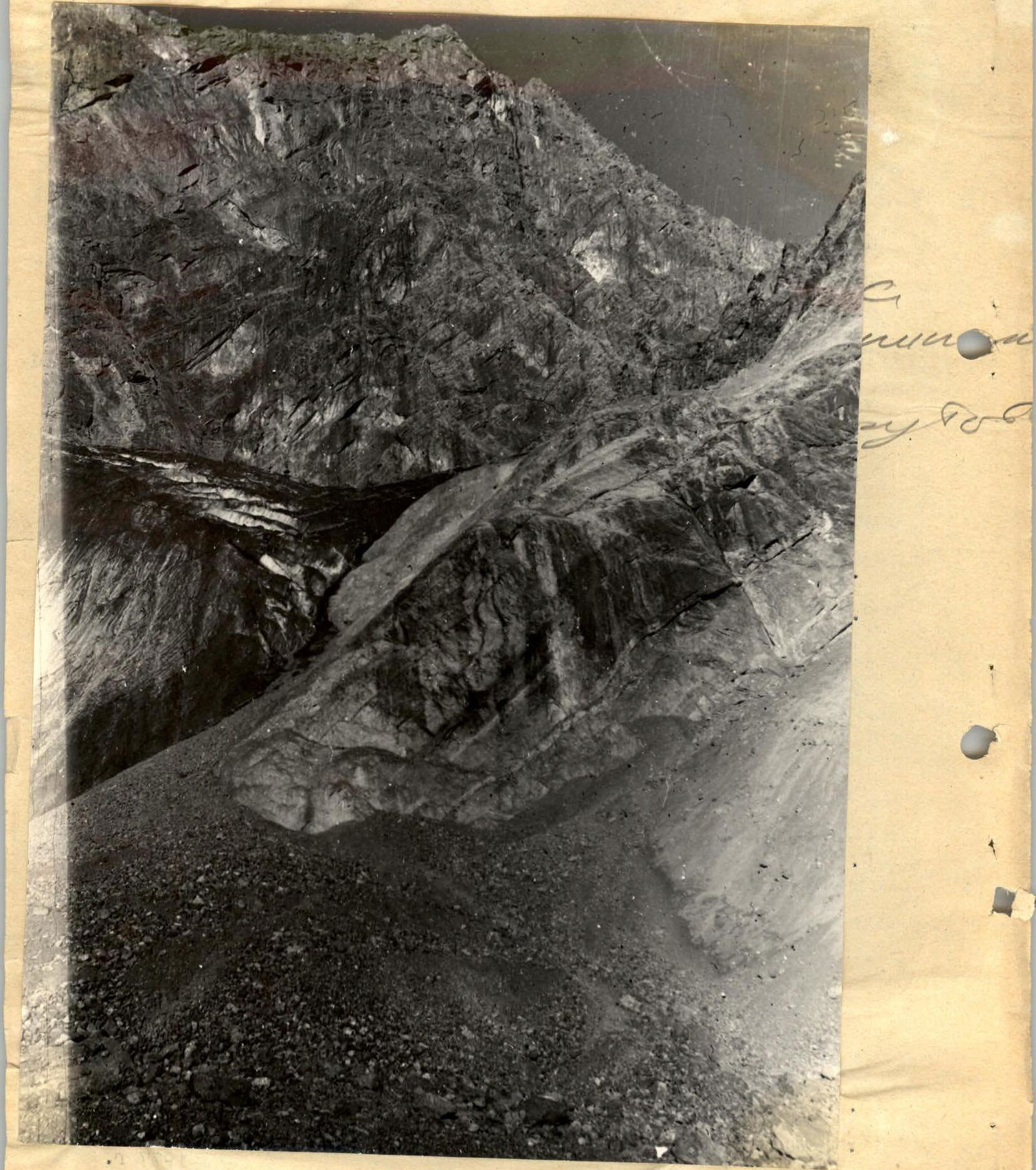
Description of the route to p. Aurondag via the north-eastern wall, approximately 5B category, second ascent.
From the base camp on "Bibi-Janat" lake, bypassing "B. Kulikalon" lake from the left, ascend via scree to the cirque of p. Maria, Rudaki, Aurondag, Znerat and stick to the right side, approaching the "ram's foreheads". Bivouac site.
From the bivouac, via "ram's foreheads" 80 m (50–60°) exit to the glacier. The route begins 60 m to the right of the "black stream" at the base of a wide internal corner of the north-eastern wall of p. Aurondag.
Section R0–R1
Via a narrow cleft and then via medium-difficulty rocks — like "ram's foreheads" 60 m (70°). Few places for piton placement. On the left, there is a risk of rockfall.
Section R1–R2
Then via a very steep wall (80°) 20 m to a narrow vertical slit. Difficult climbing, few places for belaying, rocks are smooth.
Section R2–R3
Up the narrow slit of the internal corner (like an "open book") 20 m 90°. Difficult climbing, use of wooden wedges and chocks, exit through the overhanging part of the internal corner 95–100° — 7 m, climbing is very difficult, use of artificial holds.
Section R3–R4
Exit to the left side from the internal corner 5 m (80°) and then again enter the internal corner up to the overhanging cornice 20 m (85°). Very difficult climbing.
Section R4–R5
Exit under the cornice and then left to a ledge. From the ledge via a cleft, overhanging from the upper part, to a wide ledge. 15 m (90–95°).
There is a safe place for bivouac.
Section R5–R6
From the platform, right-up via broken rocks. Up via an oblique cleft and then left-up via broken slabs to a small ridge, steeply dropping down to the left into a black huge couloir 40 m (80°).
Table of section characteristics
| Date | Designation | Average steepness | Length | Terrain characteristics | Category | Condition | Weather conditions | Rock Climbing Skills | Ice | Pitons | Wooden wedges |
|---|---|---|---|---|---|---|---|---|---|---|---|
| August 8, 1977 | R0–R1 | 70° | 60 m | cleft, "ram's foreheads" | 4 | monolithic | overcast | 10 | - | - | - |
| R1–R2 | 80° | 20 m | slit | 5 | monolithic | overcast | 4 | - | - | - | |
| R2–R3 | 90° | 20 m | narrow slit | 6 | monolithic | overcast | 4 | - | - | 5 | |
| 100° | 7 m | overhanging internal corner | 6 | monolithic | overcast | - | - | 3 | - | ||
| R3–R4 | 80° | 5 m | wall | 5 | monolithic | overcast | 1 | - | - | - | |
| R4–R5 | 85° | 20 m | internal corner | 6 | monolithic | overcast | 4 | - | - | - | |
| 95° | 15 m | ledge on 2x cleft, overhanging ledge on 4x | 6 | broken rocks | overcast | 6 | - | 3 | - | ||
| R5–R6 | 80° | 40 m | cleft, slabs, broken ridge | 5 | broken rocks | overcast | 6 | - | - | - | |
| R6–R7 | 85° | 20 m | sheer wall | 6 | broken rocks | overcast | 6 | - | - | - | |
| 90° | 20 m | cleft | 6 | icing | overcast | 7 | - | - | - | ||
| R7–R8 | 70° | 20 m | slab | 5 | broken rocks | overcast | 3 | - | - | - | |
| R7–R8 | 80° | 15 m | wall | 5 | broken rocks | overcast | 4 | - | - | - | |
| R8–R9 | 70° | 40 m | slab | 4 | monolithic | overcast | 3 | - | - | - | |
| R9–R10 | 70° | 40 m | slabs | 5 | broken rocks | overcast | 5 | - | - | - | |
| R10–R11 | 80° | 60 m | internal corner | 5 | broken rocks | overcast | 10 | - | - | - | |
| R11–R12 | 65° | 60 m | ridge | 4 | broken rocks | overcast | 4 | - | - | - | |
| R12–R13 | 60° | 40 m | ledges | 3 | broken rocks | overcast | 5 | - | - | - | |
| R13–R14 | 85° | 8 m | wall | 5 | monolithic | overcast | 4 | - | - | - | |
| 0° | 5 m | ledge on 2x | 3 | broken rocks | overcast | 2 | - | - | - | ||
| 85° | 8 m | wall | 5 | monolithic | overcast | 4 | - | - | - | ||
| 60° | 40 m | inclined ledges | 3 | broken rocks | overcast | 6 | - | - | - | ||
| R14–R15 | 65° | 40 m | ridge | 4 | broken rocks | overcast | 3 | - | - | - | |
| R15–R16 | 75° | 20 m | wall | 5 | monolithic | overcast | 5 | - | - | - | |
| R16–R17 | 55° | 60 m | ridge, ledge on 4x | 4 | broken rocks | overcast | - | - | - | - | |
| R17–R18 | 75° | 80 m | short, steep walls | 5 | broken rocks | clear, strong wind | 10 | - | - | - | |
| R18–R19 | 45° | 40 m | cleft, oblique ledge | 4 | broken rocks | " | 2 | - | - | - | |
| R19–R20 | 80° | 40 m | yellow wall | 5 | monolithic | " | 7 | - | - | - | |
| R20–R21 | 65° | 15 m | ridge | 5 | broken rocks | " | 3 | - | - | - | |
| 70° | 40 m | iced couloir | 5 | icy rocks | " | 6 | - | - | - | ||
| R21–R22 | 95° | 7 m | chip, living cork | 6 | monolithic | " | 2 | - | 4 | - | |
| 80° | 15 m | internal corner | 6 | broken rocks | " | 4 | - | - | - | ||
| R22–R23 | 75° | 30 m | traverse, "ram's foreheads", steep wall | 5 | monolithic | " | 4 | - | - | - | |
| 80° | 10 m | internal corner | 5 | icy broken rocks | " | 2 | - | 2 | - | ||
| R23–R24 | 90° | 15 m | wall | 6 | monolithic | " | 5 | - | - | - | |
| 90° | 15 m | chimney | 5 | monolithic | " | 4 | - | - | - | ||
| 85° | 15 m | wall | 5 | monolithic | " | 2 | - | - | - | ||
| R24–R25 | 80° | 30 m | "ram's foreheads", ridge | 5 | monolithic | clear, gusty wind | 4 | - | - | - |
Exit to the route — 8:00, stopped at the bivouac at 16:00. 8 climbing hours.
Bivouac conditions:
- small platform, difficult accommodation;
- organization of a running belay;
- platform is bounded by sheer drops;
- no water;
- strong cold wind.
Exit to the route — 8:00, stopped at the bivouac at 17:00. 9 climbing hours.
Bivouac conditions:
- comfortable safe platform;
- sheltered from the wind;
- ice nearby.
Section R6–R7
From the ridge, right-up under the sheer wall (85°) 20 m. Via the wall, left-up to a large cleft with ice. 20 m (90°) — very difficult climbing.
Section R7–R8
Then right-up via a slab to a ridge 20 m (70°) and left-up via a short wall, exit under a slab 15 m (80°).
Section R8–R9
Via the slab, right-up 40 m (70°) — climbing of medium difficulty.
Section R9–R10
Then right-up, crossing broken slabs 40 m (70°) (difficult climbing), under the internal corner.
Section R10–R11
Via an inclined internal corner, exit to a ridge 60 m (80°), climbing is difficult.
Section R11–R12
Up the ridge to a shoulder 60 m (65°). Few places for piton placement. Climbing is of medium difficulty.
Section R12–R13
Via the shoulder, right-up via ledges 40 m to a chimney with a cork (60°). Climbing is of medium difficulty.
Section R13–R14
Bypass the chimney with a cork via a wall 8 m (85°) left-up under the next wall. Then via a ledge left 5 m and via a steep wall 8 m (85°), exit to steep inclined ledges to the ridge of the counterfort 40 m (60°).
Section R14–R15
Via the ridge of the counterfort 40 m (65°) — medium climbing under a wet wall.
Section R15–R16
Up the wall 20 m (75°) — difficult climbing.
Section R16–R17
Then via heavily broken rocks (medium climbing, 60 m (50–55°)) — exit under the wall. Bivouac site — control tour.
Section R17–R18
From the platform via short steep walls 3–4 m (85–90°), exit up to a small ledge 80 m (60°). Average steepness of the section is 75°.
Section R18–R19
From the ledge, right-up along a cleft, and then left via an oblique ledge with snow 40 m (45°).
Section R19–R20
From here, up via strongly broken overhanging yellow walls 40 m (80°). Difficult climbing.
Section R20–R21
Then left (15 m – 65°, rocks of medium difficulty) and up via a broken couloir with ice under an overhanging yellow wall 40 m (70°). Few places for intermediate belaying.
Section R21–R22
Via a chip left to right up under an overhang (artificial holds), which is passed in the right part 7 m (95°). Through an overhanging living cork (dangerous) via a steep internal corner 15 m (80°) under a rusty wall with water flows (on ledges, ice in the second half of the summer!).
Section R22–R23
Under the rusty overhanging wall, ledge. From here, traverse left-up via a steep wall like "ram's foreheads". Difficult climbing, few places for intermediate belaying (in the upper part, loose rocks!). 30 m — 75°. Then via an internal corner 10 m — 80° (ice) in the upper part broken, exit to a balcony.
Section R23–R24
From the balcony, up via a sheer wall 15 m (90°) with short overhanging sections and then via a steep chimney 15 m (90°) (ice), ending with a wall 15 m (85°). Few holds. In the upper part of the wall, loose rocks (dangerous!) — difficult climbing.
Section R24–R25
Via steep but short walls, like "ram's foreheads", exit to the pre-summit ridge 30 m (80°) — difficult climbing.
Bivouac site. There is ice for water. Via the ridge (easy rocks), exit to the summit of Aurondag — 4573 m. Descent via the route of 3rd category. To "Bibi-Janat" lake 4–5 h.
General conclusion on the route
The route via the north-eastern wall to p. Aurondag is an interesting and logical route. The route is long and requires participants to be in good physical condition. Steepness of key sections is 90–100°. Technically, the route is complex, requiring careful equipment selection, mastery of advanced rock climbing techniques, and modern ascent tactics. The route is climbed in rubber boots. Passage in the upper part is strictly along the counterfort. On the left and right, there is a risk of rockfall. There is ice in some sections.
Recommended to be climbed in the second half of the season.
Bivouac sites are available on the route according to the description. On the second category section, there is no water.
For belaying and self-belaying, 164 rock pitons and 5 wooden wedges were driven. For artificial holds — 18 rock pitons. In two places, rope hauling was used.
Based on the experience of modern ascents of 5B–6 category on the Caucasus and in the Fann Mountains, the team members consider the route to p. Aurondag via the north-eastern wall to be corresponding to the 5B category.
Ascent experience of team members: 5B–6 category.
Caucasus:
- Traverse of Shkheldy;
- Lalar via north ridge;
- Lalar via west wall;
- Double peak via "Kant";
- Kirpich via south wall.
Fann Mountains:
- Bodkhona via west wall (Kolchin's route);
- Rudaki via left counterfort;
- Chapdara via "Sphinx".