Report
on the ascent to the summit of Aurondak (4573 m) via the northeast wall (approximately 5B category of difficulty; second ascent).
From July 15 to August 14, 1977, a team from the Kharkov regional council of the Spartak Sports Society conducted a training camp based at the Artuch resort (Fann Mountains).
The goal of the camp was to enhance the participants' sportsmanship, conduct ascents for the Spartakiad of the Ukrainian Council of the Spartak Sports Society, dedicated to the 60th anniversary of the October Revolution.
Geographical and Sports Characteristics of the Ascent Object
Between the Gissar and Zeravshan ranges rises a cluster of short but high ridges known as the Fann Mountains. The area has become known relatively recently but has already established itself as interesting. Peaks such as:
- Chaptara
- Bodkhona
- Zamok
- Mirali
- Chimitarga
- Energiya
- Zindon
- Mariya
- Rudaki
- Aurondak
require heightened attention and good preparation during ascents. This is a закономерное явление, as the peaks are mostly categorized between 4th and 6th category of difficulty.
Exploration of the area began in the 1930s, but it gained significant popularity through expeditions by the Kazakh Alpine Club starting from 1966. Much has been done to explore this area by instructors from the Artuch and Varzob alpine camps and participants in training camps.
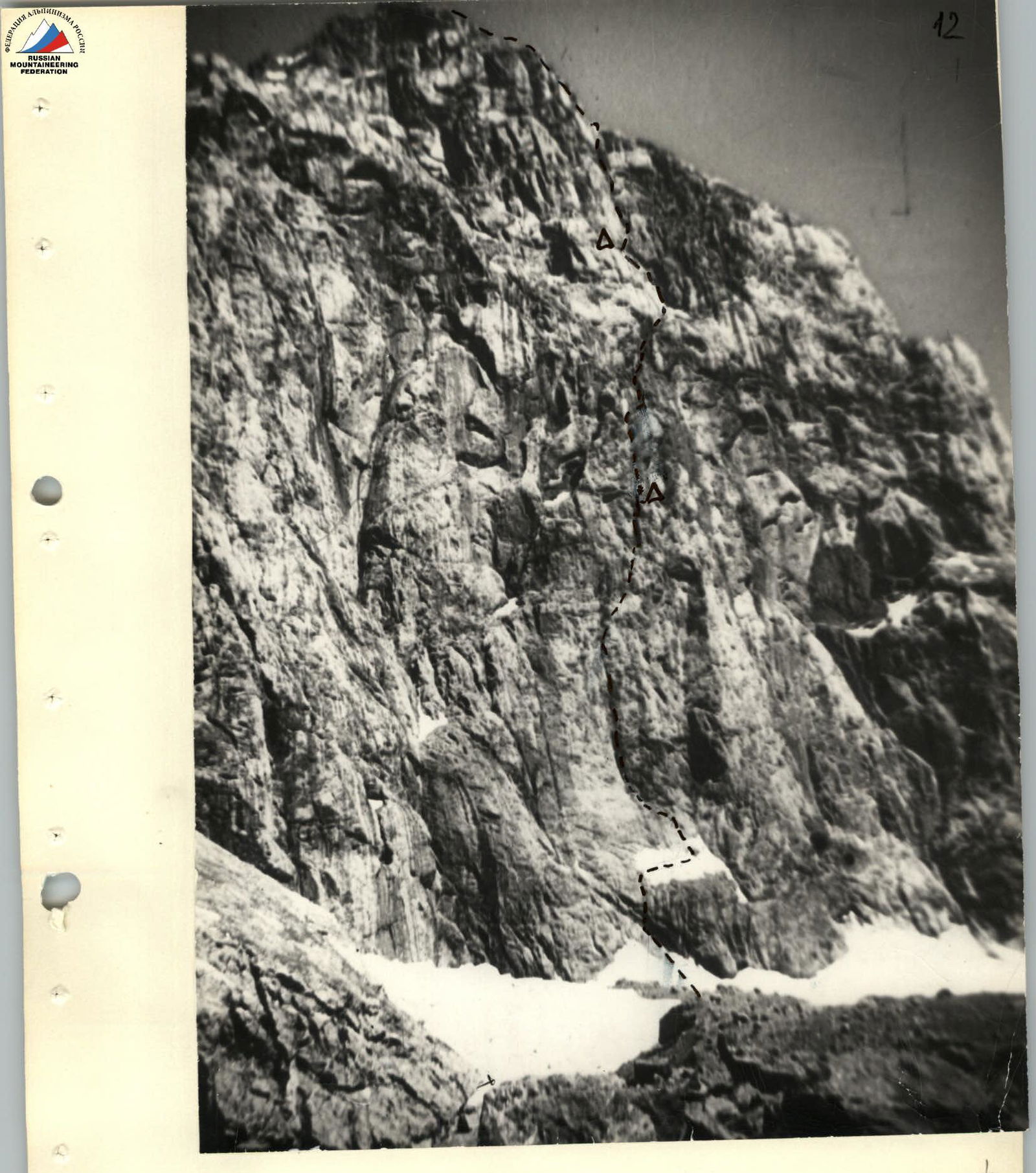
The ascent target was the summit of Aurondak (4573 m) via the northeast wall, categorized as 5B (second ascent).
We initially planned this ascent as a first ascent. However, it was discovered that a group from the Kiev "Burevestnik" had made the first ascent in July 1977.
The route appears as a wall in its lower part, transitioning into a counterfort; in its middle and upper parts, it is obstructed by sheer cliffs. Completing the route demands from participants:
- attention,
- good physical conditioning,
- technical preparedness,
- tactical preparedness.
Organization and Execution of the Ascent
Preparations for the ascent began in the winter of 1977 after the team composition was finalized and approved. Since the route is rock-based, primary focus during pre-camp preparations was on:
- rock climbing training for the team,
- manufacturing necessary equipment.
The tactical plan for the ascent was finalized and approved after consultation and observation with the head of the KSP area, M. T. Mumdina. This plan was fully executed.
The tactical plan for the ascent was as follows:
Day 1, August 7, 1977.
- Departure from the campsite at Lake Bibi-Djanat at 12:00.
- Arrival at the overnight stop under "baran'i lby" (ram's foreheads) by 14:30.
- Approach to the route, cache necessary equipment, observation.
- Descent back to the campsite.
Day 2, August 8, 1977.
Departure from the campsite at 17:00. Movement along the route, reaching the 1st control point by 17:00–18:00, processing 70–80 m of the route, overnight stay.
Day 3, August 9, 1977.
Working on the route, reaching the shoulder of Aurondak summit (4573 m) by 18:00–19:00. Overnight stay.
Day 4, August 10, 1977.
Summit ascent and descent via the 3B category route, return to the base camp.
Route Description
Day 1. August 7, 1977.
The group departed from the base camp at Lake Bibi-Djanat at 12:00, bypassed Lake Bolshoy Kulikalon to the left, and approached under the north wall of Mariya peak. Then, turning left, they arrived under the "baran'i lby" by 14:20. Here, there are convenient and safe areas for an overnight stay.
Two team members, Rybakov and Leipinger, remained to set up the campsite, while three others, Bikulov, Senetsky, and Nikolayenko, departed at 15:00 to approach the route for observation and to cache necessary equipment for the ascent. This trio returned to the campsite by 20:30. By 21:30, everyone had gone to sleep.
On the first day, they deliberately avoided preliminary route processing, opting instead to:
- study the route more closely (the team had a 20x spotting scope),
- observe rockfall paths.
Day 2. August 8, 1977.
They departed at 6:40, passed "baran'i lby" and a snow plateau, and by 8:10 approached under the northeast wall of Aurondak. The route begins to the right of the "Black Flow," at the base of a wide internal angle. The Bikulov—Leipinger rope team began the ascent first, followed by the Rybakov—Senetsky—Nikolayenko team. The rope teams alternated every 80–120 m. As the route was new and little information was available, the team had to carefully choose their path and monitor for rockfall.
All sections up to the first control point were characterized by high steepness and a lack of handholds; the rocks in many areas were "polished." Despite these challenges, the group progressed at a good pace, adhering to all safety rules.
They established a campsite near the 1st control point by 16:20. Bikulov, Senetsky, and Leipinger set up the tent and prepared food, while the Rybakov—Nikolayenko rope team proceeded with route processing. On this day, they covered 675 m and processed 80 m of the route. At section R6–R7 (see table), they organized rope hauling. The day's work ended at 21:00.
Day 3. August 9, 1977.
They departed from the campsite at 7:00 and quickly traversed the previously processed ropes. The Leipinger—Rybakov rope team led the ascent. This section presented no significant technical difficulties. From the campsite, the route proceeds directly upwards towards the "ryжая triangular" wall. The first 40 m after the processed ropes were relatively straightforward, but the presence of snow and ice on ledges required caution.
Subsequently, steep and complex rocks resumed, with the Senetsky—Nikolayenko rope team leading the way. After traversing this section, the group reached the base of a steep couloir that led to the "ryжая triangular" wall. The couloir contained:
- loose rocks,
- ice formations.
They had to navigate by switching sides within the couloir. Several short, 3–4 m, yet very steep walls were encountered. At section R21–R22 (see table), they had to employ artificial climbing techniques (ICT) and haul ropes. This was the most challenging part of the day.
From under the "ryжая triangular" wall, they traversed left along a steep slab with ice formations, reaching a "balcony." From here, they ascended directly upwards. Through steep, partially overhanging walls, and then a steep couloir and wall with loose rocks, the group reached the shoulder of the summit ridge by 18:00. Here, they set up a campsite.
They covered 352 m on this day.
Day 4, August 10, 1977. The group departed for the route at 6:00 and, after traversing a relatively straightforward summit ridge, reached the summit by 8:15.
The descent from the summit was conducted via the 3B category route. By 10:30, the group was at the campsite under "baran'i lby" and continued their descent to the base camp.
Thus, the tactical plan for the ascent was fully executed.
Route Description
July 13 (preliminary route processing from 13:00 to 18:00). The starting point of the route is marked by a wide, snow- and ice-covered ledge at the base of the wall (left of the "bottle"). Access to the ledge is via straightforward, crumbling rocks resembling "baran'i lby" (section R0–R1). From the ledge, the route proceeds left and upwards along smooth slabs (R1–R2) with an 80° incline. (There are very few places to secure pitons.) The route is directed towards a vertical chimney that occasionally transitions into an internal angle, then back to a chimney, and so on, determining the group's direction for over 200 m.
After 20 m, the smooth slabs ease to a 60° incline, and 35 m of movement in the same direction (R2–R3) lead to the base of the chimney. The initial section of the chimney, approximately 40 m (R3–R4), is completely sheer (with a control point in the middle of this section). Further, the chimney diminishes into a weakly defined internal angle (R4–R5) with an 85° incline, followed by a 10 m vertical wall (R5–R6) at 90°, and a 5 m traverse under a meter-wide cornice (very complex climbing). The cornice is bypassed on the right via a 95° wall (R6–R7), and after 5 m of complex climbing, we enter a 45 m internal angle at 85° (R7–R8), narrowing into a 5 m overhanging (95°) chimney (R8–R9) at the top.
July 14 — Day one. Departure at 9:00. After completing the pre-processed section of the route, we enter an internal angle (R9–R10) 35 m long, with an incline of 80° on polished rocks with few handholds. 2nd control point. Further, after complex climbing along a 40 m wall (R10–R11) at 85°, we reach a ledge. To the right below, a ledge is visible where the first ascenders set up their overnight stay. From the ledge, the route proceeds upwards along a 30 m wall (R11–R12) at 80° (the latter half transitions into a sheer drop). A piton is hammered in. Movement involves ladders for 5 m. Further, 10 m of traverse to the right towards a crack. Along the 95° crack (R12–R13), we ascend 5 m using ladders, and then along a narrow ledge on a sheer wall for 30 m (R13–R14), approaching the base of a large rock outcrop resembling a "glove." Ascending onto the "glove" involves a 20 m internal angle (R14–R15) at 90°, formed between the wall and the side of the "glove." Then, a ledge — the "glove's finger" — and another 15 m ascent along an overhanging chimney at 95° (R15–R16) to the top of the "glove." (The chimney contains some ice).
19:00. Overnight stay atop the "glove." Comfortable area. Below in the chimney, there is ice.
July 15 — Day two. Departure at 8:00. Movement directly upwards (R16–R17) along an internal angle (70 m) at 80°, overhanging in the upper part from 95° to 100° over 10 m (R17–R18). Further, over 40 m, there's a gradual easing to 85° (R18–R19) — (at this point, the route intersects with V. Sidelnikov's route) — and after overcoming a 3 m sheer section (R19–R20), we move right and upwards along a 40 m wall (R20–R21) at 75° towards the base of a bastion (intersecting with A. Kolchin's route). A 50 m section (R21–R22) at 70° leads to the base of the bastion, ending in a black 3 m overhang (R22–R23) at 80°. Complex traverse for 10 m (R23–R24) along a sheer wall, followed by ascent (R24–R25) along a 10 m wall at 90°, and another 15 m traverse (R25–R26) under overhanging rocks to the base of a 5 m vertical internal angle (R26–R27). After the angle, movement involves traversing (R27–R28) right and upwards for 40 m along a wall at 75–80° towards a waterfall from the black cliffs, and after overcoming a 5 m wall (R28–R29) at 90° using ladders, we reach a wide, debris-filled ledge with snow. Traversing the ledge for 40 m (R29–R30) and then left and upwards along a wide internal angle, initially on snow (30 m) at 45° (R30–R31), then on rocks of medium difficulty for 80 m (R31–R32) at 75°.
19:00. Overnight stay. Good platforms. Water available.
July 16 — Day three. From the overnight stay location, directly upwards, there's a 5 m vertical wall (R32–R33), followed by a 80 m section (R33–R34) at 80° right and upwards, leading to a 70 m internal angle (R34–R35) at 75–80°. Further, the angle eases (R35–R36), and over 65 m, it has a 70° incline. A 10 m overhanging wall (R36–R37) leads to a 10 m niche (R37–R38) at 50°. Ascending to the top of the bastion involves an internal angle 35 m long at 70° (R38–R39). After three hours of movement along straightforward (65°) crumbling rocks (R39–R40), intersecting scree, a narrow ledge (R40–R41) 140 m long, and a summit dome at 60° covered in fine scree — we reach the summit by 15:00.
Descent follows the ascent path in the direction of the NW edge, category 5B. Further right (along the descent path) from the NW edge, we rappel down "baran'i lby" for 350 m onto the glacier. By 21:00, the group had returned to the base camp.
Table
of main characteristics of the ascent route
| Date | Designation | Average steepness in degrees | Length in meters | Relief characteristics | Difficulty | Condition | Weather conditions | Rock Pitons | Ice | Shoulder. |
|---|---|---|---|---|---|---|---|---|---|---|
| I | 2 | 3 | 4 | 5 | 6 | 7 | 8 | 9 | IO | II |
| July 13. Route processing from 13:00 to 18:00 | R0–R1 | 60–70 | 100 | "baran'i lby" (snow 40 m). | III | Crumbling rocks | Clear | 4 | - | - |
| R1–R2 | 80 | 20 | Smooth slabs | V | Monolithic | -»- | 6 | - | - | |
| R2–R3 | 60 | 35 | -»- | IV | -»- | -»- | 7 | - | - | |
| R3–R4 | 90 | 40 | Chimney (1 control point 15 m from start) | VI | -»- | -»- | 9+П | - | - | |
| R4–R5 | 85 | 15 | Internal angle | V | -»- | -»- | 4 | - | - | |
| R5–R6 | 90 | 10 | Vertical wall | VI | -»- | -»- | 8+I | - | - | |
| R6–R7 | 95 | 5 | -»- | VI | -»- | -»- | 6+I | - | - | |
| R7–R8 | 85 | 45 | Internal angle | VI | -»- | -»- | 13 | - | - | |
| R8–R9 | 95 | 5 | Chimney | VI | -»- | -»- | 2 | - | - | |
| July 14. Departure at 9:00 | R9–R10 | 80 | 35 | Internal angle (2 control points) | V | -»- | -»- | 8 | - | - |
| Overnight stay at 19:00. Total travel hours — 10 | R10–R11 | 85 | 40 | Wall | VI | -»- | -»- | 14 | - | - |
| R11–R12 | 80 | 30 | Wall | V | -»- | -»- | 9+П | - | I | |
| R12–R13 | 95 | 5 | Wall with cracks | VI | -»- | -»- | 2+I | - | ||
| R13–R14 | 90 | 30 | Traverse along wall | VI | Monolithic | Clear | 5 | - | ||
| R14–R15 | 90 | 20 | Internal angle | VI | -»- | -»- | 5 | - | ||
| R15–R16 | 95 | 15 | Chimney | VI | Rocks covered in ice | -»- | 5+П | - | ||
| Overnight stay. Comfortable area. Ice available. | ||||||||||
| July 15 | R16–R17 | 80 | 60 | Internal angle | VI | Monolithic | -»- | 14 | - | |
| R17–R18 | 95–100 | 10 | -»- | VI | -»- | -»- | 4+I | - | ||
| R18–R19 | 85 | 40 | -»- | VI | -»- | -»- | 8 | - | ||
| R19–R20 | 90 | 3 | -»- | VI | -»- | -»- | 3 | - | ||
| R20–R21 | 75 | 40 | Wall | V | -»- | -»- | 7 | - | ||
| R21–R22 | 70 | 50 | -»- | V | -»- | -»- | 7 | - | ||
| R22–R23 | 80 | 3 | Wall | VI | -»- | -»- | 4 | - | ||
| R23–R24 | 90 | 10 | Traverse along sheer wall | VI | -»- | -»- | 2 | - | ||
| R24–R25 | 90 | 10 | Wall | VI | -»- | -»- | 4 | - | ||
| R25–R26 | 90 | 15 | Traverse under overhanging rocks | VI | -»- | -»- | 3 | - | ||
| R26–R27 | 90 | 5 | Internal angle | VI | -»- | -»- | 4 | - | ||
| R27–R28 | 80 | 40 | Wall | V | -»- | -»- | 10+I | - | ||
| R28–R29 | 90 | 5 | Wall | VI | -»- | -»- | 3 | - | ||
| R29–R30 | - | 40 | Ledge | IV | -»- | -»- | 2 | - | ||
| R30–R31 | 45 | 30 | Snow slope | III | Monolithic | -»- | ||||
| R31–R32 | 75 | 80 | Internal angle | V | Wet rocks | -»- | 7 | - | ||
| Departure on July 15 at 8:00. Overnight stay at 19:00. Total travel hours — 11. | ||||||||||
| Overnight stay conditions: good platforms, water available. | ||||||||||
| July 16 | R32–R33 | 90 | 5 | Wall | VI | Monolithic | Clear | 2 | - | |
| R33–R34 | 80 | 80 | Wall | VI | -»- | -»- | 17+П | - | ||
| R34–R35 | 75–80 | 70 | Internal angle | V | -»- | -»- | 12 | - | ||
| R35–R36 | 70 | 65 | Internal angle | V | Crumbling rocks | -»- | 14 | - | ||
| R36–R37 | 90 | 10 | Wall | VI | Monolithic | -»- | 5+I | - | ||
| R37–R38 | 50 | 10 | Niche | IV | -»- | -»- | 2 | - | ||
| R38–R39 | 70 | 35 | Internal angle | V | Crumbling rocks | -»- | 6 | - | ||
| Arrival at the top of the bastion at 12:00. | ||||||||||
| Arrival at the summit at 15:00. | ||||||||||
| Descent to base camp by 21:00. |
The group's route