Report
on the ascent to the summit of Alaudin via the southern counterfort ("Parasail") (I. Sandalov's route, 72) category 4A on July 25, 2019
I. Ascent Passport
| № | 1. General Information | |
|---|---|---|
| 1.1 | Full name, sports rank of the leader | Merkuryeva V.A. — Master of Sports |
| 1.2 | Full name, sports rank of the participants | Zhdanov I.M. — 2nd sports rank |
| 1.3 | Full name of the coach | |
| 1.4 | Organization | |
| 2. Characteristics of the ascent object | ||
| 2.1 | Region | GISSAR-ALAI, Fann Mountains — northern part |
| 2.2 | Valley | Alaudin |
| 2.3 | Section number according to the 2013 classification table | 5.3.1 |
| 2.4 | Name and height of the summit | Alaudin, 4134 m |
| 2.5 | Geographical coordinates of the summit (latitude/longitude), GPS coordinates | |
| 3. Characteristics of the route | ||
| 3.1 | Name of the route | via the southern counterfort ("Parasail") (I. Sandalov's route, 72) |
| 3.2 | Proposed category of complexity | 4A |
| 3.3 | Degree of route exploration | - |
| 3.4 | Character of the route terrain | rock |
| 3.5 | Route elevation gain (altimeter or GPS data) | 404 m (from the pass) |
| 3.6 | Route length (in meters) | 440 m (wall section, including 20 m rappel), 200 m (approach via couloir) |
| 3.7 | Technical elements of the route (total length of sections of various complexity categories with terrain character indication) | 1st cat. complexity rocks — 200 m (approach via couloir) 2nd cat. complexity rocks — 80 m 3rd cat. complexity rocks — 215 m 4th cat. complexity rocks — 95 m 5th cat. complexity rocks — 30 m Rappels: — from "Parasail" to the saddle — 20 m — on the descent from the summit — 2 sections of 20 m each |
| 3.8 | Descent from the summit | Descent via 2A category route towards Alaudin pass |
| 3.9 | Additional route characteristics | - |
| 4. Characteristics of the team's actions | ||
| 4.1 | Travel time (team's walking hours, in hours and days) | 10 hours |
| 4.2 | Overnight stays | - |
| 4.3 | Route start | 06:00, July 25, 2019 |
| 4.4 | Summit ascent | 13:00, July 25, 2019 |
| 4.5 | Return to base camp | 16:00, July 25, 2019 |
| 5. Person responsible for the report | ||
| 5.1 | Full name, e-mail | Zhdanov Ilya Mikhailovich, snb.flex@gmail.com |
II. Ascent Description
1. Characteristics of the Ascent Object
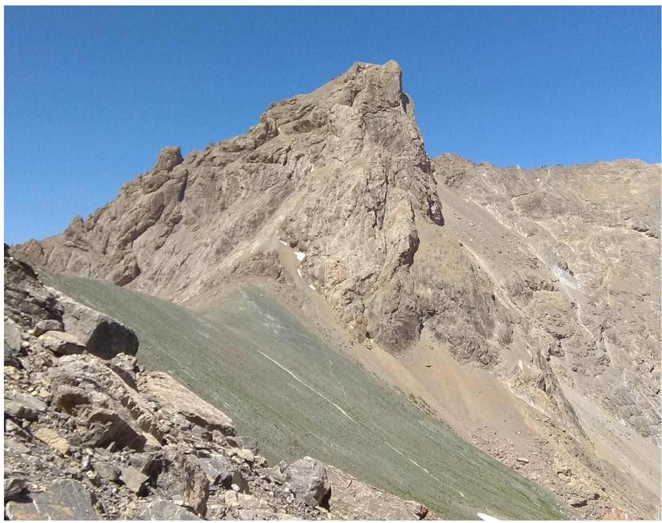
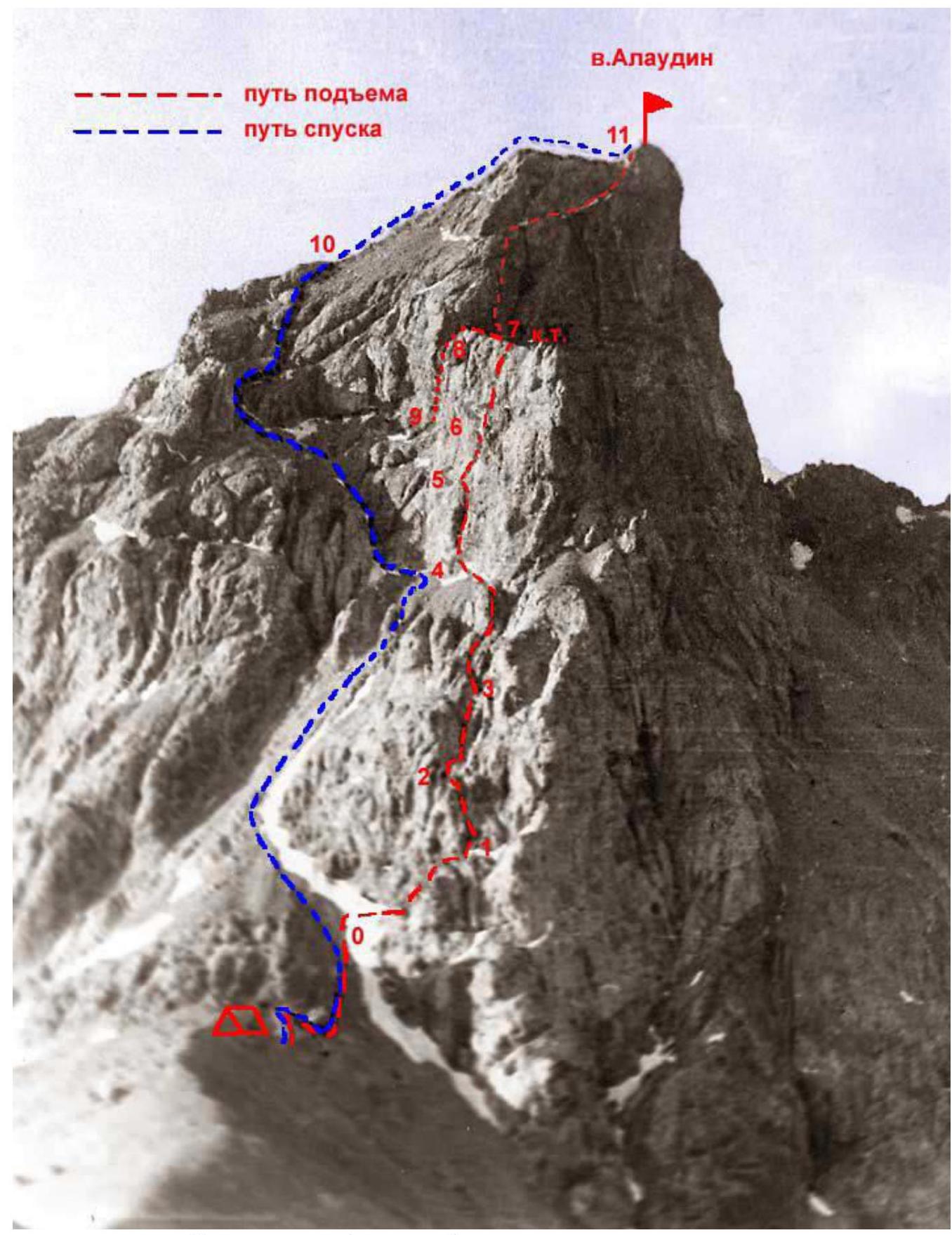
Alaudin summit and pass. Photo from the ridge of Severny summit. July 24, 2019
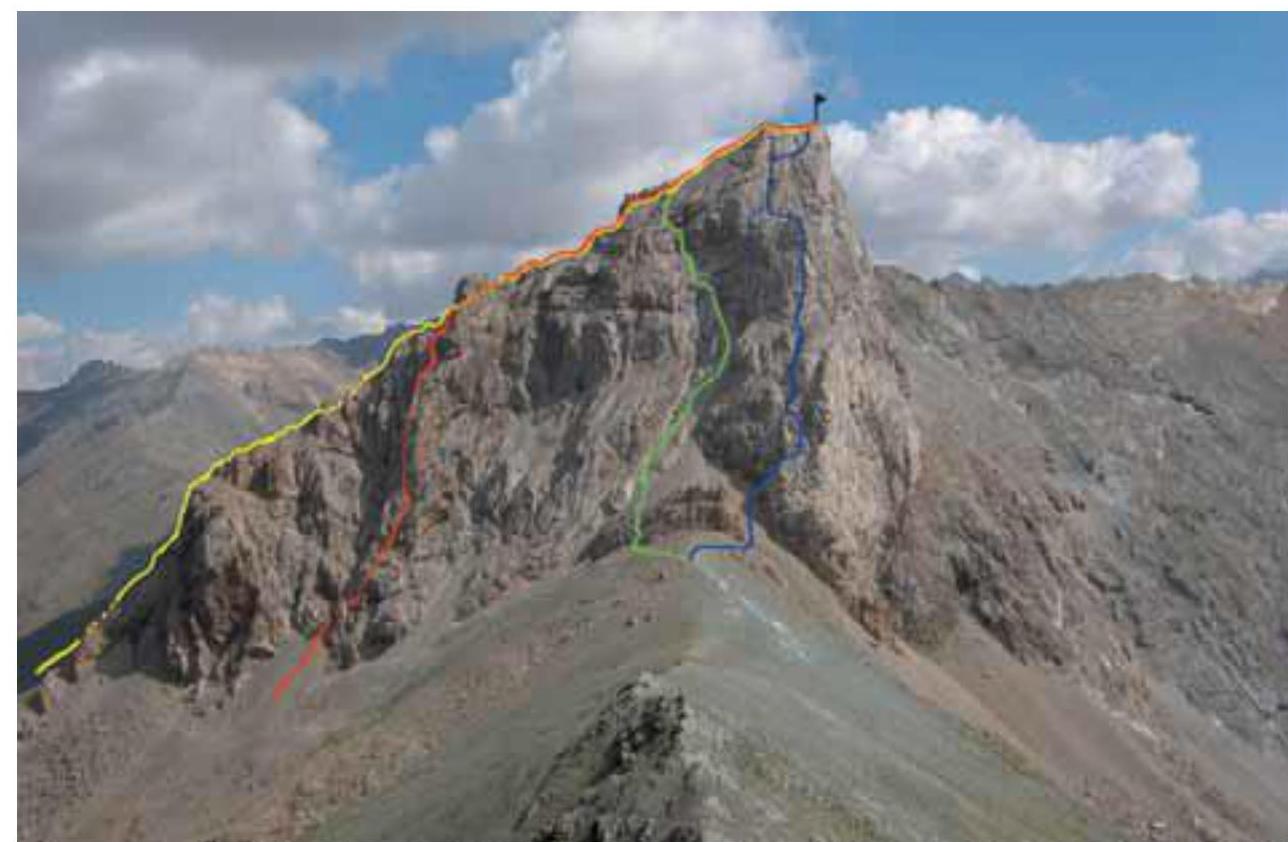
Alaudin summit and pass. Photo from Severny summit. Photo from RISK onsite guidebook.
Blue thread — 4A category route (via S counterfort, I. Sandalov) — the route taken. Green thread — 2A category route (via SW couloir) — descent route. Red thread — 3B category route (via S counterfort 3rd ridge, E. Zhitny). Yellow thread — 3A category route (via 3rd ridge, P. Karpov).
Alaudin summit from the approach to Alaudin pass from Kulikalon lakes. Photo from RISK onsite guidebook.
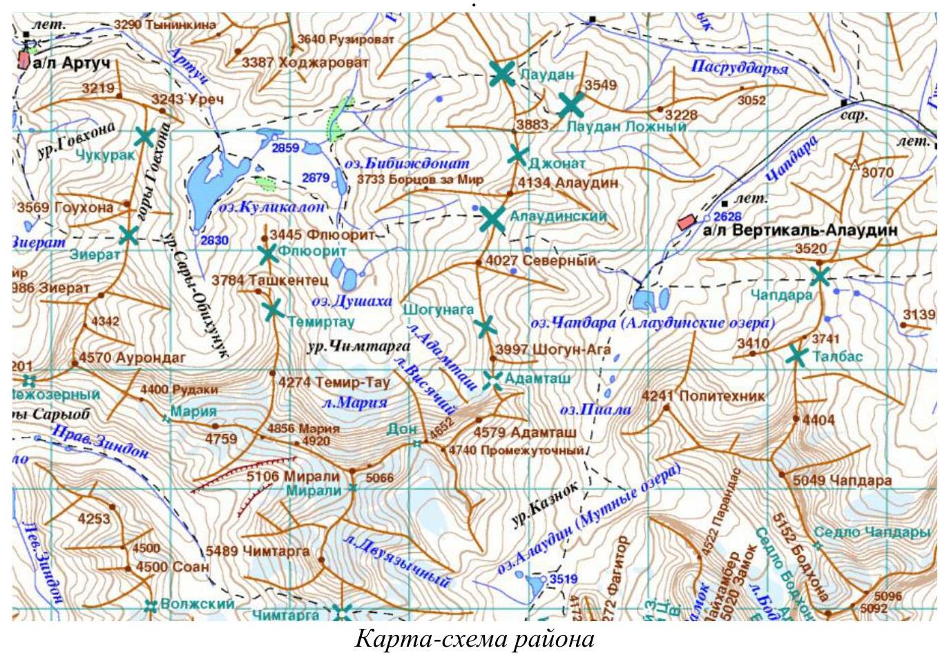
Area map.
The approach to the route is possible from "Vertikal-Alaudin" AL or from "Artuch" AL from different sides of Alaudin pass.
A good trail leads to the pass. Marked on the map above with a black dashed line. The path from "Vertikal-Alaudin" AL to overnight stays under Alaudin pass took about 2 hours.
2. Route Characteristics
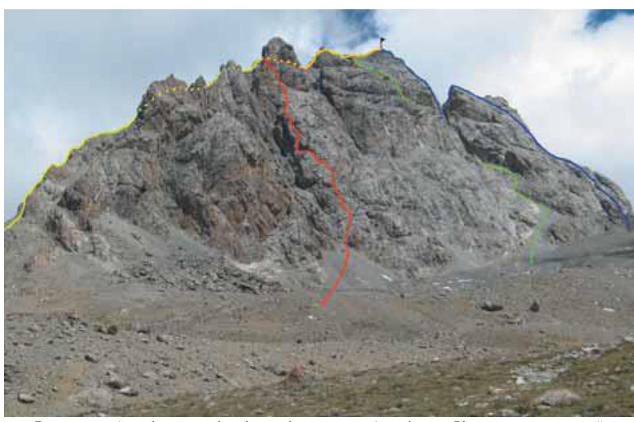
Technical photograph of the route with sections. View from the side of Severny summit. Photo from: http://www.fanyvertical.ru/↗
Technical characteristics of route sections
| Section № | Terrain character | Category of complexity | Length, m | Steepness, ° |
|---|---|---|---|---|
| R0–R0 | Scree slope | 1 | 200 | 30 |
| R0–R1 | Rocks | 3 | 40 | 30 |
| R1–R2 | Rocks | 3 | 15 | 45 |
| R2–R3 | Rocks | 4–5 | 35 | 60–80 |
| R3–R4 | Rocks | 3 | 30 | 30–40 |
| R4–R5 | Rocks | 3 | 100 | 45 |
| R5–R6 | Rocks | 3–4 | 40 | 60 |
| R6–R7 | Rocks | 4–5 | 30 | 80 |
| R7–R8 | Rocks | rappel | 20 | |
| R8–R9 | Rocks | 4 | 30 | 60 |
| R9–R10 | Rocks | 3–4 | 20 | 50–60 |
| R10–R11 | Rocks | 1–2 | 80 | 30 |
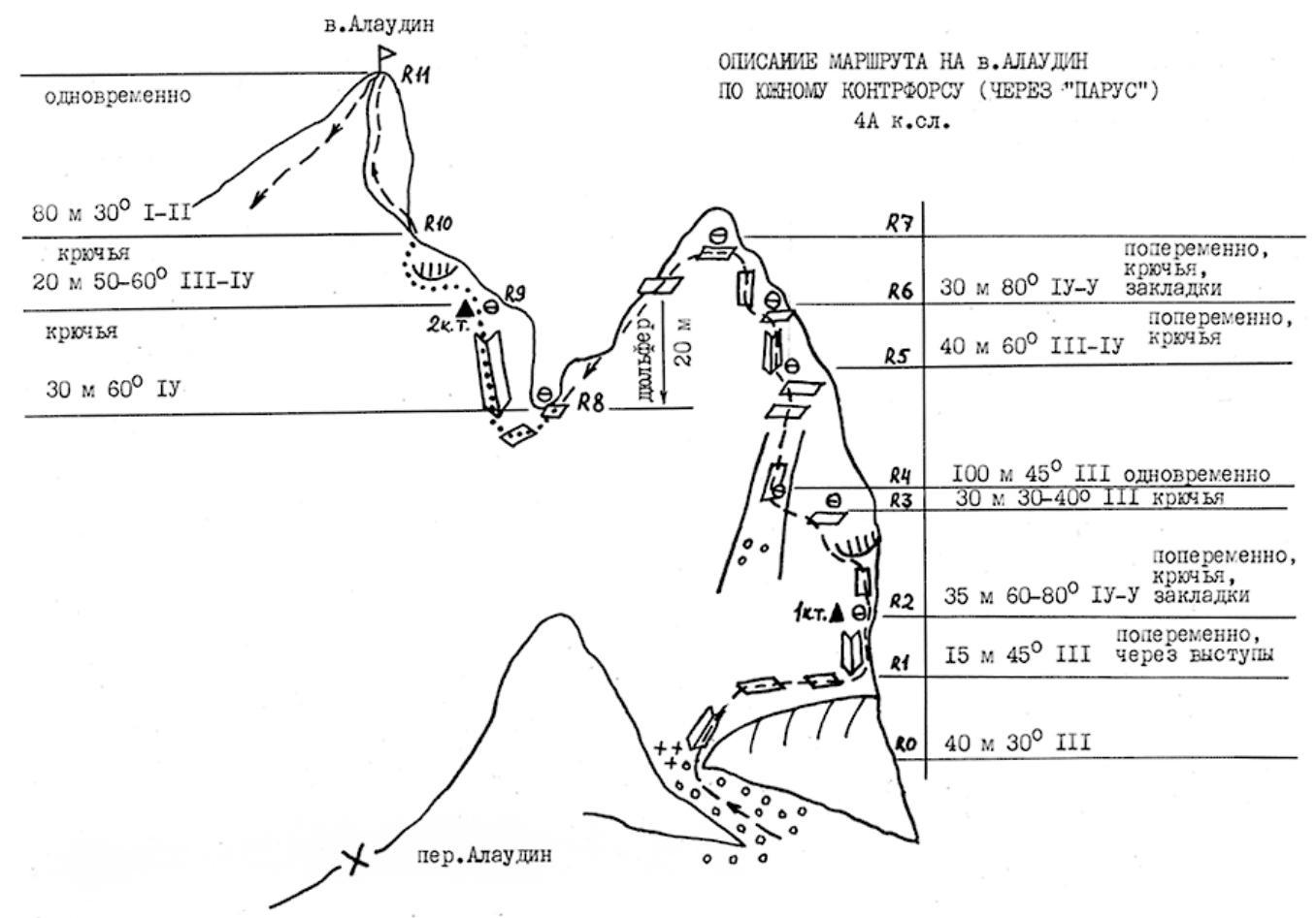
Technical scheme of the route with sections and UIAA symbols. Image taken from: http://www.fanyvertical.ru/↗
The route starts with a traverse via scree around the rocky outcrop and exit through a wide, destroyed couloir.
R0–R1: After exiting the couloir, move right onto scree shelves. Simultaneous movement. 40 m.
At the start of the route on the shelf, a stone cairn is built. On the rock, there is an inscription "4А".
R1–R2: Up from the "4А" inscription. In the upper part of the wall, move slightly right. Alternating movement. 15 m.
R2–R3: The section is passed first to the right under the overhang, and then through a crack in its left part, exit up the wall (60°) to a shelf convenient for setting up a belay. 35 m.
R3–R4: Moving left and up, transition into a wide couloir. It's challenging to find a spot for a belay station. You can move left and choose a spot on friction. 30 m.
R4–R5: Exit via the couloir slightly right onto shelves almost on the ridge of "Parasail". Simultaneous movement. 100 m.
R5–R6: Enter the inner corner in the left part of the shelves. 40 m.
R6–R7: The steep wall has many loose rocks. Pitons are better placed in the first half of the wall. Then follow the ridge of "Parasail" to its summit. 30 m.
R7–R8: From the summit of "Parasail", move left and down to a platform with loops for descent. The rappel ends on the saddle between "Parasail" and the summit ridge. The platform accommodates no more than two people. 20 m.
There's also an option to rappel further down and right onto a scree shelf (25 m is enough) at the start of the wall (station on an anchor and small nuts).
R8–R9: Belay via a bolt hanger on the saddle. Descend from the saddle right and down onto a scree shelf 2 m (you can rappel directly onto it). Then, in the right part of the large inner corner, slightly moving right at the start. In the beginning, there's scarce relief for belay. 30 m.
R9–R10: Then move left under the overhangs, bypassing them, and exit onto the pre-summit ridge. 20 m.
R10–R11: Move to the right and bypass the wall via a small shelf. Simple rocks lead to the summit. 80 m.
Descent
Descent via 2A category route towards Alaudin pass.
There are 3 rappel sections of 20 m each: — The first two can be descended by climbing. — The first section is immediately after the pre-summit ridge. — After the first section, you need to descend a bit and turn almost 180°.
The entrance to the descent couloir is marked by a large cairn built under a small, sharp gendarme. From here, rappel or climb down.
After descending a bit, there's a belay station for the next rappel. On it, there's a risk of dislodging rocks during descent. Those who have descended should exit the rockfall-prone descent couloir as far as possible.
Recommendations on Equipment
Camalots (friends) worked well. Nuts were used rarely. In three places (on different ropes, once on a station), anchor pitons were used.
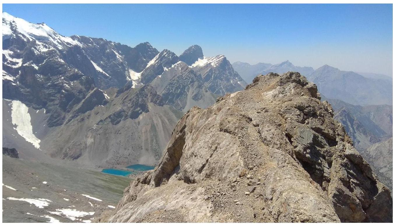
Photo from the summit on July 25, 2019, 13:15
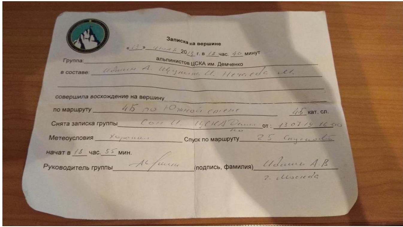
Note from the summit