To the Classification Commission under the USSR Alpine Federation and the USSR Central Sports Club, Moscow.
Description
Traverse of the Kulikalon Wall (v. Adamtash – p. Promezhutochny – East Mirali – Main Mirali – Main Maria – Uzlovaya Maria – West Maria – v. Bezymyannaya – p. 4300 – v. Aurondag – v. Zierat) with ascent to v. Adamtash via the Eastern Edge.
Approximately 50 km of technical terrain.
Fann Mountains, Pamir-Alai, 1968.
1. Data on Traverse Participants
The traverse of the Kulikalon Wall was completed by the LOS SDSO "Burevestnik" team consisting of:
Traverse leader: Vadim Aleksandrovich Korotkov, born 1940, CMS, engaged in mountaineering since 1959.
Traverse participants:
- Svet Borisovich Tikhvinsky, born 1928, CMS, engaged in mountaineering since 1947, team doctor.
- Genrikh Mikhailovich Vylegzhanin, born 1931, MS, engaged in mountaineering since 1951.
- Alexander Grigorievich Lipchinsky, born 1944, 1st sports category, engaged in mountaineering since 1963.
- Vladimir Leonidovich Strchek, born 1938, 1st sports category, engaged in mountaineering since 1961.
- Yuri Glebovich Karpov, born 1941, 1st sports category, engaged in mountaineering since 1961.
- Sergey Georgievich Kalmykov, born 1939, 1st sports category, engaged in mountaineering since 1960.
- Vadim Rafailovich Lurie, born 1942, 1st sports category, engaged in mountaineering since 1961.
5. Route Description
July 21. The group departed from the base camp at Lake Dushakha, located in the eastern cirque of the Kulikalon Wall, at 8:00 AM. Initially, the path follows a trail, then a glacier descending from the Adamtash Pass. The panorama of the traverse from v. Adamtash to v. Maria is visible throughout. The ascent is uncomplicated, and by 11:00 AM, they reached the last ascent to the pass next to the wall of v. Adamtash.
They descended into the Alauddin valley. The terrain then consisted mainly of scree and grassy slopes. They skirted the eastern ridge of v. Adamtash from the left and, after a tiring ascent on scree, reached its shoulder from the south by 4:00 PM. The altitude is ~3800 m. They set up a bivouac.
After resting and having a snack, the pair Kalmykov and Lipchinsky proceeded to process a 250-meter ascent starting directly from the bivouac (sections 1 and 2). The ascent is a wall about 100 m wide, shaped like a concave mirror. The terrain consists of smooth slabs with a steepness gradually increasing from 50° to 80°. A crevice runs along the right edge of the wall, sometimes interrupted and changing direction. They planned to ascend via this crevice. The pair wore galoshes, took 4 ropes, sections 1 and 2). They wore galoshes, took 4 ropes, pitons, and proceeded. The others set up the bivouac, observed the pair's work on the wall. By 8:45 PM, they descended from the wall, having securely anchored all the ropes and removed excess intermediate pitons. A portion of the wall remained for the next day.
July 22. Departure at 6:00 AM. The first pair to depart was Karpov–Lurie. They quickly traversed the anchored ropes and processed another 2 ropes on the route (section 2). The entire group completed the wall passage by 9:30 AM.
Further along the ridge, the terrain is significantly simpler: disintegrated rocks, snow (section 3). They moved mostly simultaneously. This section ends with a snow slope with a steepness of ~40°. After traversing this slope, the ridge steepness increases, the terrain becomes rocky with rocks of medium difficulty. Movement was alternating, with some sections having fixed ropes and piton belays (section 4). The ridge leads to a meeting point with the northern ridge, forming a pre-summit rocky ascent (section 5). Climbing is challenging; the first climber ascended without a backpack and in galoshes, with fixed ropes.
The distance to the summit is short. The ridge abruptly changes steepness (section 6). Rocks, scree, simultaneous movement. They bypassed a gendarme on the left and reached the pre-summit. From there, they descended via a rope (section 7) and reached v. Adamtash via heavily disintegrated rocks and scree (section 8). The time was 3:00 PM.
They rested. The further route was unclear. The ridge to p. Promezhutochny is heavily jagged, making the route choice ambiguous. Therefore, they decided to bivouac on the summit, as it was a convenient location, and dedicate the remaining daylight to reconnaissance and route processing.
At 4:30 PM, Korotkov and Tikhvinsky departed for reconnaissance and processing. After climbing through gendarmes, they found a viable route (Fig. 7). After the summit, they initially descended along the ridge (section 9) – simple, heavily disintegrated rocks, then bypassed a group of gendarmes by descending along the eastern side of the ridge (section 10) to a steep snow ascent (section 11), which led back to the ridge beyond a large gendarme. The entire bypass was relatively simple and mostly traversed simultaneously.
Korotkov–Tikhvinsky managed to traverse part of the ridge (sections 12–14):
- Section 12 is a steep rocky wall, complicated by the fragility of the rocks, which have a tiled structure.
- Section 13 is straightforward; it's a ridge with rocks and snow, leading to a smoothed rocky ascent (section 14), which presented a significant challenge. The rocks are smooth with very small holds.
With difficulty, Korotkov anchored a rope and quickly descended. It was already late. Another rope was left on section 12, and the pair quickly returned to the bivouac (9:30 PM).
July 23. Departure at 7:00 AM. The first pair to depart was Lipchinsky–Tikhvinsky. The group quickly traversed the previously reconned route without wasting time on path selection.
The next section, 15, is a simple rocky ridge leading to a challenging rocky wall (section 16) about 40 m high. The rocks are disintegrated.
Lipchinsky hammered in 6 pitons and ascended without a backpack; the others followed with fixed ropes.
The ridge then became less steep, with rocks and snow (section 17). The rocks are of medium difficulty. Movement was alternating with piton belays and natural protection.
The next rocky ascent (section 18) was initially attempted head-on, then traversed to the right to bypass a gendarme. The bypass was particularly challenging, requiring a traverse of an overhanging wall section while suspended over a void. The first climber ascended without a backpack; the others followed with fixed ropes.
The route then became simpler. Along snow and easy rocks, they bypassed (on the left) the last large gendarme before the summit of p. Promezhutochny and reached a saddle beyond it (section 19).
It turned out that p. Promezhutochny is somewhat offset from the ridge, which turns west towards v. Mirali. They left their backpacks on the saddle and ascended to p. Promezhutochny:
- Initially along steep, disintegrated rocks (section 20), with fixed ropes.
- Then along a snow slope (section 21) to the summit.
They descended via the ascent route to the saddle. A short rest, and at 2:30 PM, they continued.
The first pair, Korotkov–Karpov, led the way and organized the descent.
Initially, they encountered a section of moderately steep, heavily disintegrated rocks (section 22) (3 sports). Then the ridge abruptly dropped (section 23). They began descending along the left side of the ridge. The group was large, so the descent route was chosen to ensure shelter at each rappel point, preferably away from falling rocks. The descent was conducted with great caution (one moved while the others were in shelter). Thus, 5 rappels were organized.
Kalmykov and Lurie worked efficiently on rope retrieval. The descent was completed without incident.
Further, they bypassed (on the left) the red and black gendarmes in the ridge leading to Mirali (sections 24, 25, and 26). Section 24 involved snow and rocks, alternating movement, and piton belays. Section 25 required a traverse along rocks of medium difficulty, with a steepness of 60°, movement on fixed ropes. Section 26 involved rocks of medium difficulty, exiting onto the ridge, alternating movement, and piton belays.
They then followed a straightforward ridge (section 27) to a broad, scree-covered saddle before ascending to Mirali (section 28). Here, they set up a bivouac (7:30 PM).
July 24. Departure at 7:15 AM. Karpov and Lurie led. The ascent to Mirali began on the left along a fairly steep (45°) snow slope (section 29). The snow was very hard, making it difficult to create steps. The other participants quickly caught up with the first pair, and by constantly changing the lead, the group rapidly gained altitude.
Towards the end of the section, they encountered rocks, which were overcome with belays using natural protection and an ice axe. They exited to the right onto the ridge.
The route then followed the ridge to v. East Mirali (section 30). The ridge was straightforward, snowy, but the altitude and backpacks were challenging. By 10:30 AM, they reached the summit. The ridge to v. Main Mirali presented no difficulties (sections 31, 32). By 11:15 AM, the group gathered on the summit of Main Mirali.
The descent began towards v. Maria along a heavily disintegrated rocky ridge, partially covered in snow and ice (section 33). The ridge was wide and prone to rockfall. They navigated this section with great caution.
The ridge became steeper (section 34), increasing the risk of rockfall. Movement was alternating, with careful attention to falling rocks.
Next, they performed a rappel descent (section 35). The rappel was anchored to a large outcrop, as there was no suitable location to hammer in a piton.
The first two gendarmes in the Mirali–Maria ridge (Fig. 10) were bypassed on the left along scree slopes and disintegrated rocks (sections 36, 37, 38), leading to a broad scree saddle in the ridge before a very steep, partially overhanging ascent to the summit tower of Maria. Here, they set up a bivouac (4:00 PM). An attempt to find a bypass for this gendarme was unsuccessful. Therefore, they decided to process and reconnoitre the route along the ridge.
At 5:00 PM, Korotkov and Kalmykov, wearing galoshes, departed to process the route. Korotkov began the ascent on a double rope. The rocks were steep and partially overhanging (section 39). The ascent was complicated by the fragility of the rock, requiring cautious progression. The ascent initially went straight up the gendarme, then exited to the right side of the ridge, which dropped steeply with a 1.5 km vertical face.
They traversed the first rope, hammering in 10 pitons and deploying two ladders. Kalmykov then followed, advancing another 20 m and adding 5 pitons. The exit to the top of the ascent was simpler, with rocks of medium difficulty (section 40).
A relatively straightforward route to the summit tower of Maria was visible. With available time, the pair decided to approach the summit tower and outline a route. Without significant difficulties, they traversed the ridge to the summit ascent (sections 41–42), leaving pitons as needed. This ridge section was rocky and heavily disintegrated.
After scouting the ascent route to the summit, the pair returned to the bivouac at 8:00 PM. An additional rope was left on the steep ascent for upper belays and rucksack retrieval the next day.
July 25. Departure at 7:30 AM. Kalmykov, Lurie, and Lipchinsky ascended via the fixed ropes and began the laborious task of retrieving rucksacks (Fig. 11). The other participants then followed with upper belays and fixed ropes.
The ascent to the summit tower of Maria was led by Kalmykov–Lurie (Fig. 12). Initially, a steep 40-meter rocky wall (70°) (section 43), followed by a traverse along a sharp ridge (section 44) directly beneath the summit ascent (section 45). The first climber wore galoshes and ascended without a backpack. The rocks in the lower section were heavily disintegrated, but became more solid and complex higher up. Climbing was challenging, with several overhanging sections requiring artificial holds. 18 pitons were hammered in during this section. By 2:30 PM, the group gathered on the summit of Maria.
From the summit, they descended along the ridge via a rope, then followed a relatively straightforward rocky ridge with some sections of medium difficulty climbing (section 46). On a gentle ridge, they encountered a steep descent (section 47). Finding suitable cracks for piton placement was very challenging. In this location, the disintegrated ridge consisted of crumbling tiles. After a lengthy search for cracks, they hammered in three pitons, blocked them, and organized a rope descent.
They then bypassed a small gendarme on the left, traversing a broad, smooth rocky ridge to reach v. Uzlovaya Maria (sections 48–49).
They reached the summit at 5:30 PM. From the summit, they followed a straightforward ridge to a broad scree saddle before v. West Maria (sections 50, 51). Here, they set up a bivouac (6:00 PM).
July 26. Departure at 7:00 AM. A straightforward, broad ridge with scree and snow led to v. West Maria, where they left a note (sections 52, 53).
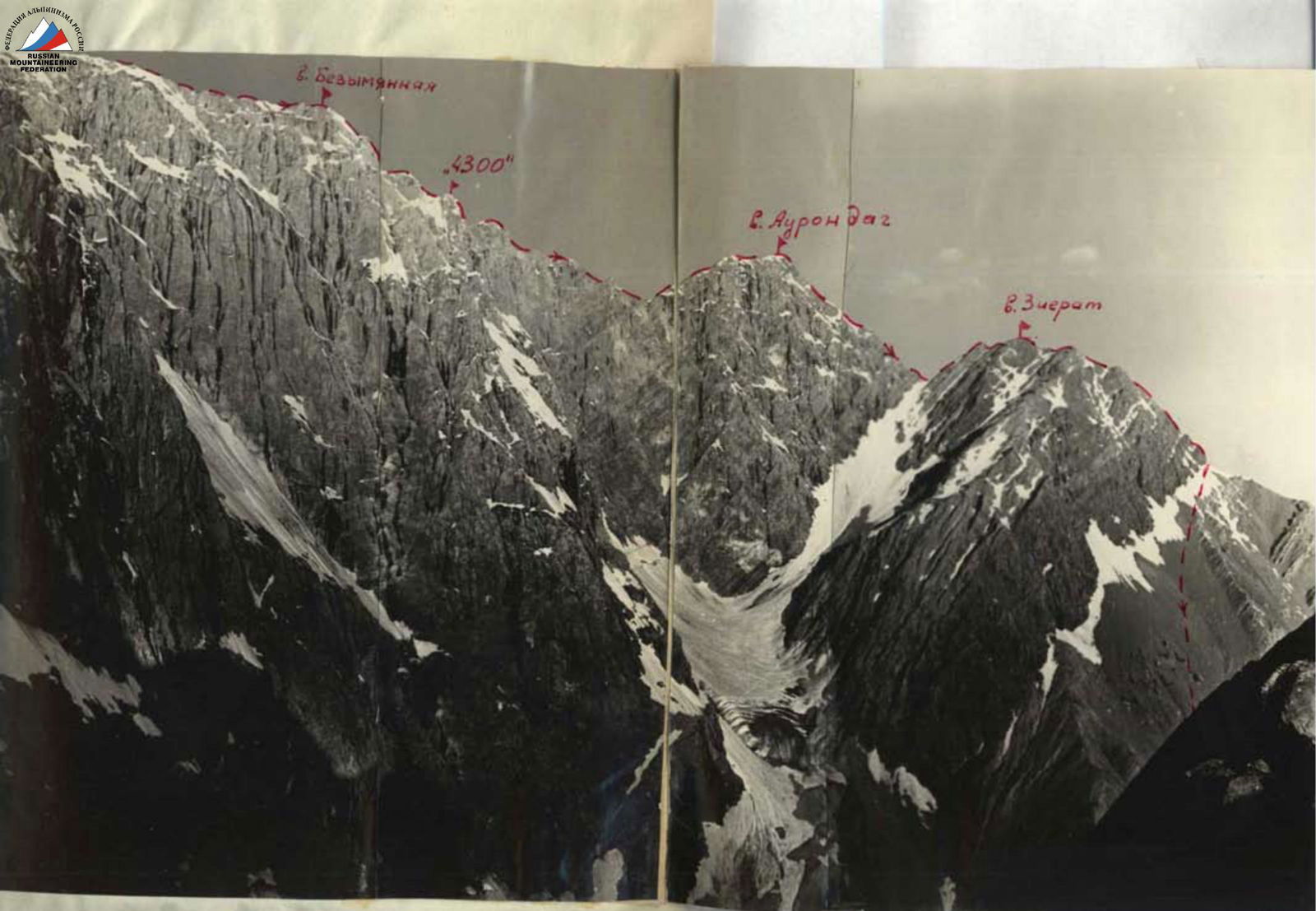
Approaching v. Bezymyannaya, the ridge gradually narrowed and became more complex (sections 54, 55).
Some sections required alternating movement with natural protection. By 10:30 AM, they reached v. Bezymyannaya. The summits on this traverse section were not particularly pronounced, and the ridge was not heavily jagged. Therefore, the passage presented no significant challenges. The terrain was primarily rocky.
They quickly traversed the "4300" summit and descended to a saddle before v. Aurondag (sections 56, 57, 58). On the descent, they organized two rappels.
From the saddle to v. Aurondag, the ascent took 1.5 hours (section 59). The rocks were not difficult, with simultaneous movement and some alternating movement with natural protection.
By 12:00 PM, the group reached v. Aurondag. At 12:30 PM, they began their descent. The ridge was heavily disintegrated with sharp drops (sections 60, 61, 62). Movement was strictly along the ridge.
From the summit to the saddle before v. Zierat, they organized 10 sports rappels with rope retrieval. In one location (section 61), they used pitons for the descent. On the saddle at 4:30 PM, they rested. At 5:00 PM, they continued their ascent to v. Zierat.
The ridge was not steep, with simple rocks and simultaneous movement, except for short sections (section 63).
After v. Zierat, the ridge remained straightforward, with simultaneous movement (section 64).
The summit of Zierat is a fairly broad massif. After traversing it, they began descending along a heavily disintegrated rocky ridge (section 65).
By 7:00 PM, they descended to the grass and followed grassy and scree slopes to Lake Kulikalon. From there, they returned to the base camp at Lake Dushakha, arriving at 9:00 PM.
6. Overall Route Characteristics (Fig. 13)
| Characteristic | Value |
|---|---|
| Route length | 14030 m |
| Ridge length from v. Adamtash to v. Zierat (map) | 10000 m |
| Height difference along the traverse: 5170 – 4100 = | 1070 m |
| Length of complex traverse sections | 1200 m |
| Average steepness of complex sections | 75° |
| Pitons hammered: rock | 224 |
| expansion | 2 |
| Walking hours | 64 |
| Including processing and reconnaissance | 10.5 |
The route is logical. The most challenging part of the traverse is from v. Adamtash to v. Maria. The group assesses the traverse as a category 5B route.
9. Table of Main Technical Characteristics of the Kulikalon Wall Traverse
(v. Adamtash – p. Promezhutochny – v. East Mirali – v. Mirali – v. Maria – v. Uzlovaya Maria – v. West Maria – v. Bezymyanaya – p. 4300 – v. Aurondag – v. Zierat).
| Date | Section # | Average Steepness | Section Length | Terrain Characteristics | Technical Difficulty | Passage Method and Belays | Departure Time | Bivouac Time | Walking Hours | Processing and Reconnaissance Time | Rock Pitons | Bivouac Conditions | Daily Ration Weight |
|---|---|---|---|---|---|---|---|---|---|---|---|---|---|
| July 22 | 1 | 55° | 100 | rocks | medium difficulty | fixed ropes, piton belays | 6:00 | 2.5 | 10 | ||||
| 2 | 70° | 160 | rocks | difficult | fixed ropes, piton belays | 18 | |||||||
| 3 | 40° | 240 | rocks, snow | easy | simultaneous | ||||||||
| 4 | 50° | 240 | rocks | medium difficulty | alternating, piton belays | 10 | |||||||
| 5 | 65° | 200 | rocks | difficult | fixed ropes, piton belays | 20 | |||||||
| 6 | 30° | 180 | rocks, scree | easy | simultaneous | ||||||||
| 7 | 65° | 40 | rocks | medium difficulty | rope descent, piton belays | ||||||||
| 8 | 45° | 70 | rocks, scree | easy | simultaneous | 15:00 | 9 | 1 | lying on scree | 750 g | |||
| July 23 | 9 | 30° | 400 | disintegrated rocks | easy | simultaneous | 7:00 | 5 | |||||
| 10 | 40° | 300 | rocks, snow | easy | simultaneous | ||||||||
| 11 | 40° | 200 | snow | easy | simultaneous | ||||||||
| 12 | 60° | 40 | rocks | difficult | fixed ropes, piton belays | 4 | |||||||
| 13 | 20° | 80 | rocks, snow | easy | simultaneous | ||||||||
| 14 | 65° | 40 | rocks, ice | very difficult | fixed ropes, piton belays | 5 | |||||||
| 15 | 25° | 120 | rocks | easy | alternating, piton belays | 4 | |||||||
| ... | ... | ... | ... | ... | ... | ... | ... | ... | ... | ... | ... | ... |
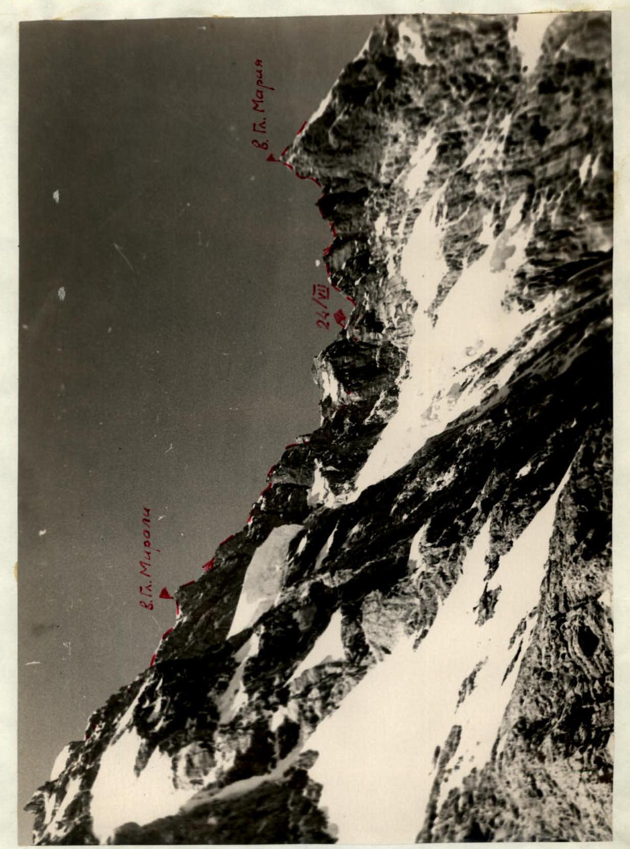
Fig. 10. Traverse section between v. Mirali and v. Maria.

Fig. 12. Summit tower of Maria. Section 45.
Fig. 2. Voronaya tower of Maria.

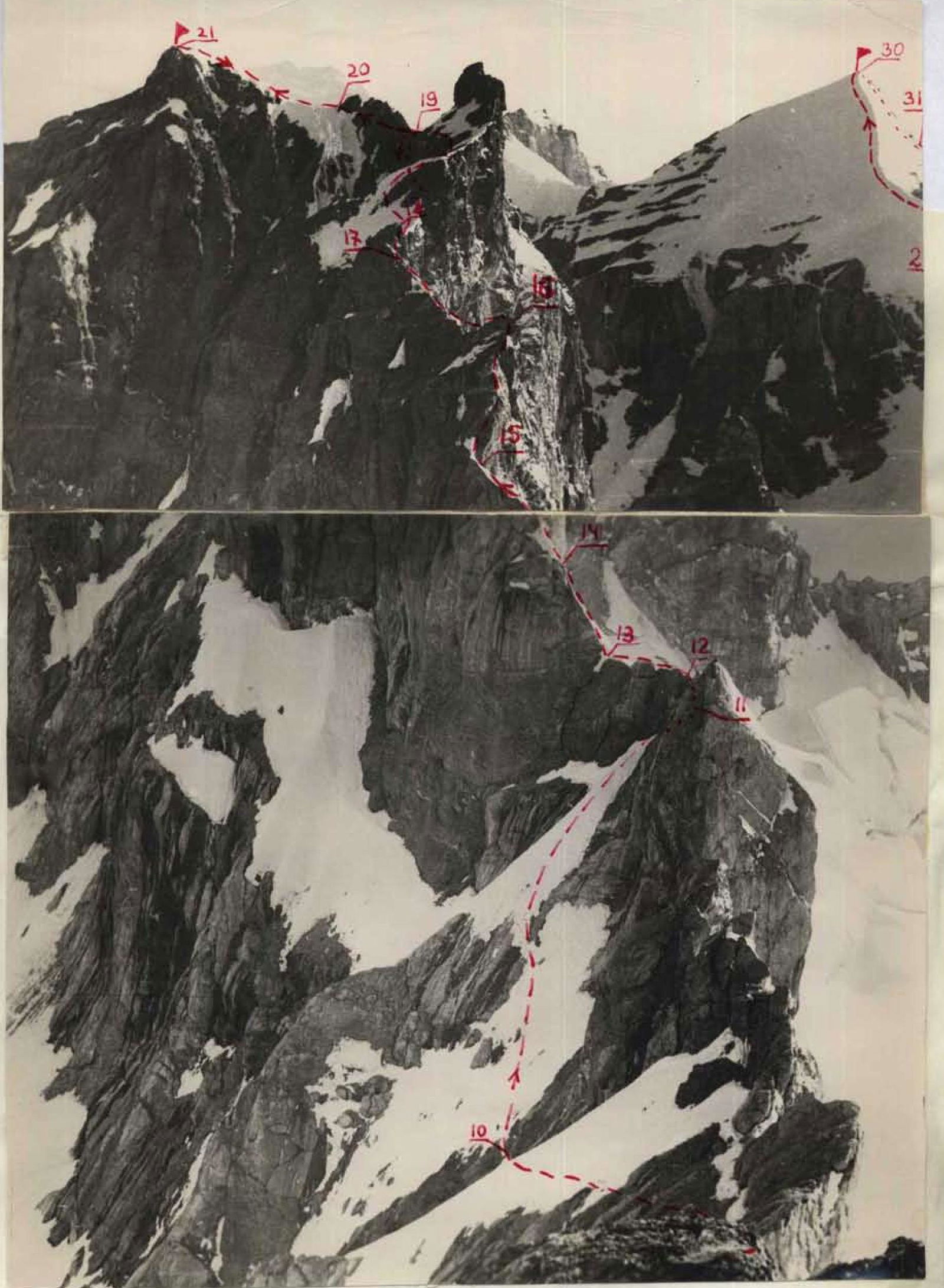
Fig. 7. View from v. Adamtash to the traverse section to p. Promezhutochny. v. Main Mirali is visible on the right.