
Ascent Passport
I. Rock class 2. Fann Mountains, Tagrich gorge 3. Peak 4200, via the southeast wall (Glushko route) 4. 5B category of difficulty, third ascent 5. Height difference: 670 m, length — 770 m Length of sections with 5B category of difficulty — 235 m 6 category of difficulty — 320 m Average steepness of the route — 78° Average steepness of the wall — 83° 6. Pitons driven:
- rock: 9
- bolt: 4 + I X
- chocks: 83/2
- ice screws: 0 X — use of previously driven pitons I — including loops thrown over ledges
- Team's travel hours: 26 and days: 3
- Overnights: 1st — one person in a hammock, three on a rock ledge. 2nd — four on a rock ledge
- Leader: Glubokov Alexander Vasilyevich, Candidate Master of Sports Team members:
- Klepinin Arkady Vladimirovich, Candidate Master of Sports
- Nechaev Vladimir Vyacheslavovich, Candidate Master of Sports
- Smirnov Evgeny Viktorovich, Candidate Master of Sports
- Coach:
- Mamonov Valentin Ivanovich, Candidate Master of Sports, category II instructor-methodologist
II. Departure to the route: July 8, 1988 Summit: July 10, 1988 Return: July 10, 1988

Photo #1. General photo of the summit.
- Kapitanov's route,
- "Aragats" alpine club route,
- Team's route (Glushko). Date taken July 7, 1988, 13:00; Lens Mir-1V, 37 mm, distance 1.0 km, shooting point #2, H = 3300 m.
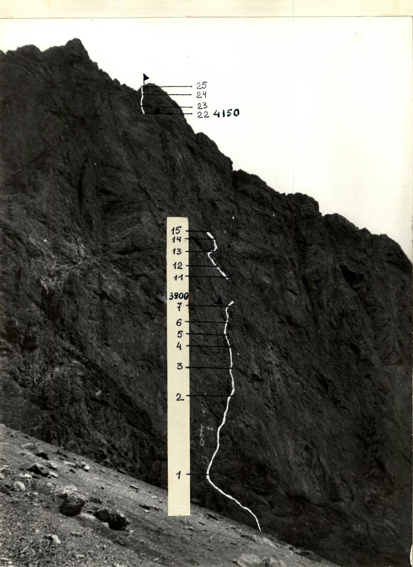
Photo #2. Photo of the wall profile from the left
- team's route. Date taken July 7, 1988, 12:00, lens Mir-1V, 37 mm, distance 400 m, shooting point #3, H = 3400 m.
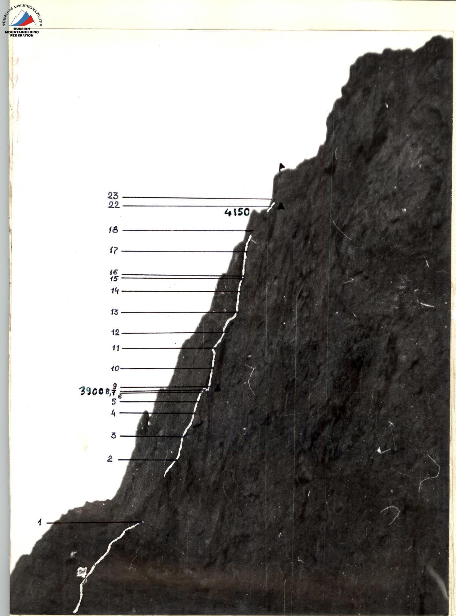
Photo #3. Photo of the wall profile from the right
- team's route. Date taken July 10, 1988, 21:00; Lens Minitar I, 32 mm; distance 700 m, shooting point #4, H = 3200 m.
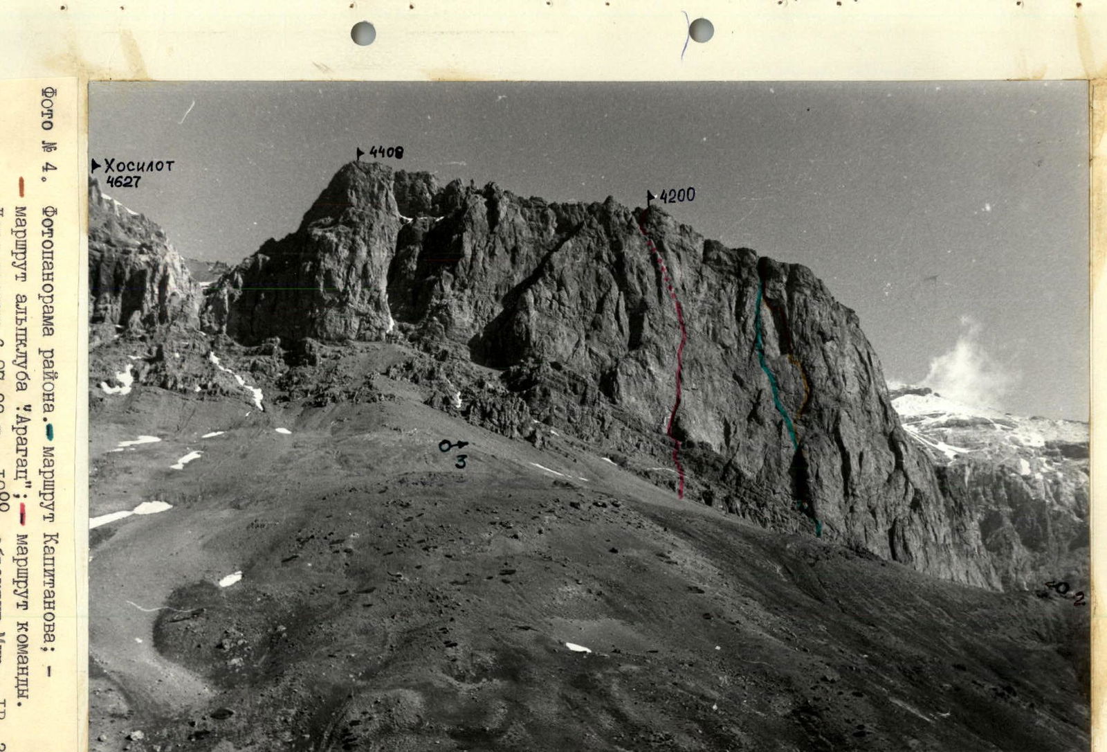
Photo #4. Photopanorama of the area.
- Kapitanov's route;
- "Aragats" alpine club route;
- team's route. Date taken July 6, 1988, 10:00, lens Mir-1V, 37 mm; distance 2.5 km, shooting point #1, H = 3500 m.
Description of the route by sections
R0–R1. The route begins at the lowest part of the wall. The section is an alternation of rock walls 3–5 m and inclined ledges. R1–R2. Climbing up through the right part of the inner corner to a horizontal ledge 0.3 × 1 m. A convenient place for belay. During the ascent, off-center cams and other medium-sized chocks were used as belay points. R2–R3. Climbing up and to the right through a steep narrow crack (5 m), ending in a series of small horizontal ledges. Opportunities for organizing belay points are minimal (petal-shaped pitons). A bolt pito should be driven from the last ledge. Further up, a vertical wall. There is micro-relief for climbing, but practically no cracks. The wall leads to a sheer inner corner. End of the second rope. R3–R4. Inner corner with an overhang in the middle part. A crack runs through the center of the corner. Chocks of medium and large sizes are used. The corner ends with a chip, convenient for setting up a belay station to receive a partner. R4–R5. Sheer wall. Difficult to organize intermediate belay. Exit to a small shelf under the cornice. R5–R6. The cornice is passed on the right through a hanging narrow crack. R6–R7. Climbing up through the right part of the inner corner. Exit to a ledge where 1 belay anchor is set, a convenient place for an overnight stay. R7–R8. Difficult traverse to the right with a slight descent. Moving away to a vertical rib. Further straight up through a sheer large-block wall (in the second half of the day, a stream flows, climbing is difficult and unpleasant), exit to a wide inclined slab. The exit from the wall onto the slab is very difficult because the holds are wet and water-worn, and it is practically impossible to organize a belay. Traverse the slab to the right to the end. R8–R9. A large inner corner goes up. Entering it through a steep crack. Here, a belay station should be set up. Although the place is not very convenient, it won't get any better. R9–R10. Climbing up through a smooth inner corner to a narrow ledge. R10–R11. Sheer inner corner, wet in the second half of the day. Climbing up through the right part to a place where the corner narrows, and the right part starts to overhang. Organizing belay is complicated; there are loose rocks. A very difficult transition across wet rocks to the left side to a horizontal ledge. There are no cracks; a belay station is set up on two bolt pitons. First crux.
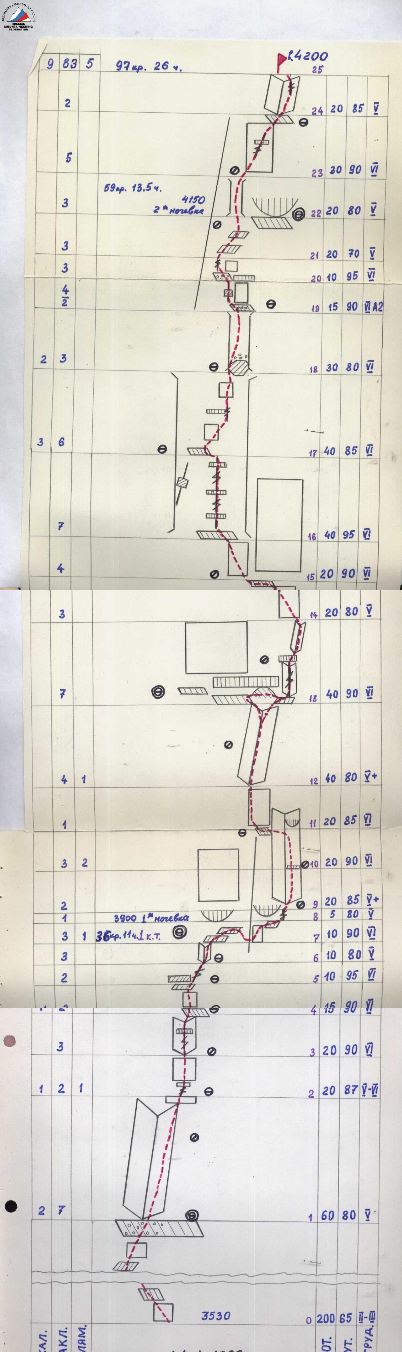
Route diagram in UIAA symbols
- R11–R12. A steep frontal slab is passed on the left. Problem with organizing belay.
- R12–R13. An inclined inner corner (dry in the morning) leads under a cornice.
- R13–R14. Traversing under the cornice to the left leads to ledges where the 2nd belay anchor was set and there are places for overnight stay. To continue on the route, the cornice should be bypassed on the right (a stream flows here in the second half of the day). From the overnight stay area, a difficult traverse to the right is made under an overhang in a large niche. Further, a 10 m corner-crack leads under the cornice. The cornice is passed on the right (difficult section), and then — through an inclined inner corner under a smooth vertical wall.
- R14–R15. Moving up and to the left and traversing along a 10 cm intermittent flake.
- R15–R16. Climbing up and to the left through destroyed rocks to the base of a chimney on a ledge.
- R16–R17. A wide, wet chimney with several overhangs. Passed "head-on" by free climbing through cracks inside the chimney. Climbing in a wide chimney with wet, smooth rocks is extremely difficult. Second crux. Exit to a wide 1.5 × 0.7 m convenient ledge on the left. A diagonal hanging crack runs along the left part of the chimney, passable with artificial aids.
- R17–R18. The chimney becomes less steep and narrower. After 15 m, another overhang is encountered, which is passed through a diagonal crack. It is convenient to set up a belay station on a cork filled with small debris from above. Exactly 40 m straight from the previous ledge.
- R18–R19. The chimney narrows to 1.5 m, passed in a wide stance, rocks are smooth.
- R19–R20. A ledge with snow leads to a 15 m wall. The right crack is dry but overhanging; the left is wider, sheer, and wet. The ascent is made through the left crack in a wide stance on tiny holds. Psychologically difficult climbing. When passing a small overhang, artificial aids were used.
- R20–R21. A debris-filled ledge and a hanging crack. Climbing through the crack is strenuous and difficult.
- R21–R22. A series of inclined ledges. Difficult to organize belay. Caution, many loose rocks.
- R22–R23. A wide chimney-couloir is passed on the left. On the right, there is an exit to a wide ledge under an overhang where a convenient overnight stay can be organized.
- R23–R24. A vertical wall on the right is passed through a wide crack, through a small overhang to a wide inner corner. Here, there are convenient cracks for setting up a belay station. Caution, loose rocks.
- R24–R25. Through the right crack of the inner corner, approaching a steep crack (3 m) leading to the summit.
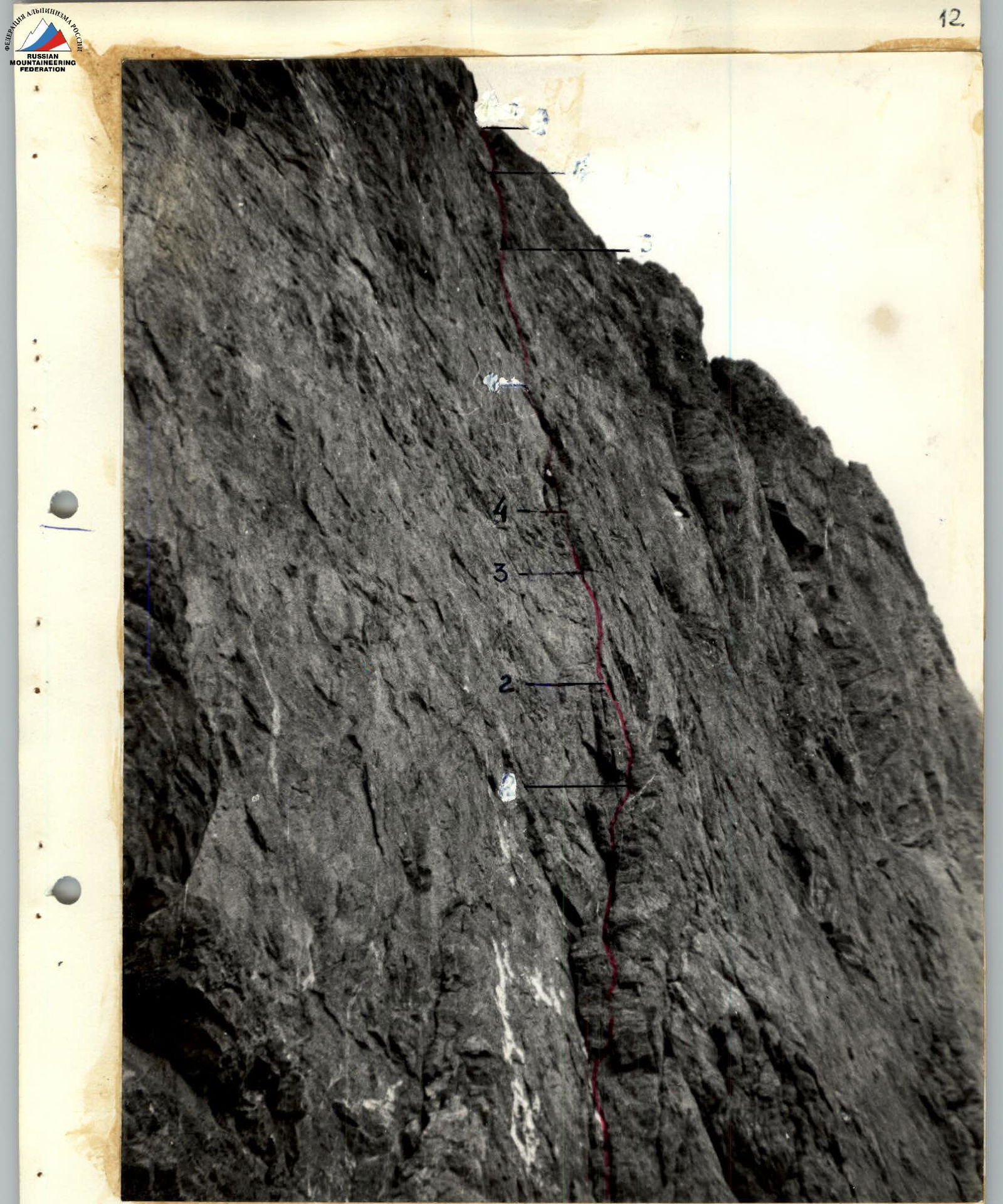
Photo #6. Sections R1–R4. Date taken July 8, 1988, 9:00, lens Minitar I, 32 mm; shot from section R0–R1.
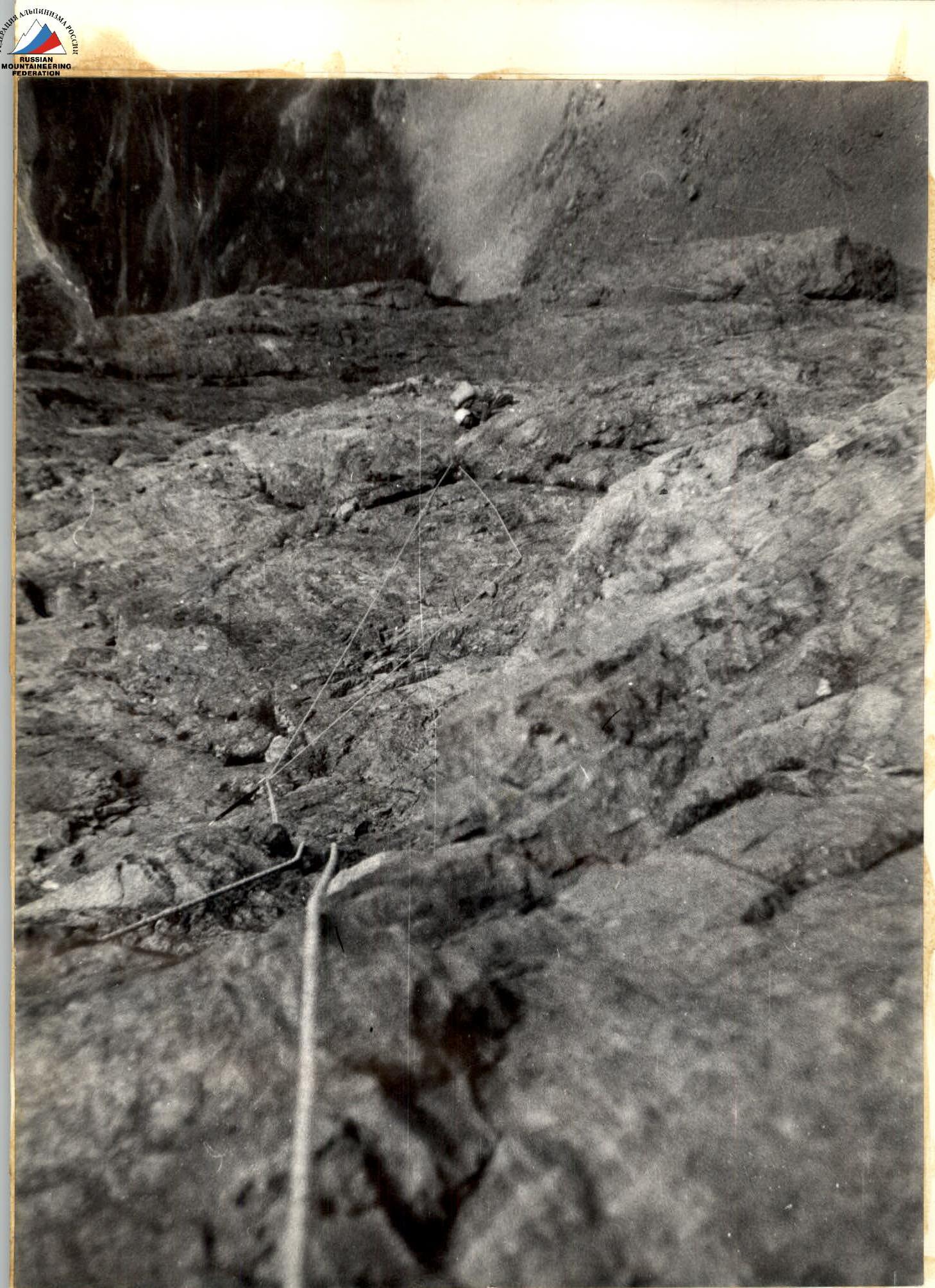
Photo #7. Sections R4–R7. Smirnov E. is moving along the rope. Date taken July 8, 1988, 16:30, lens Minitar I, 32 mm; shot from the 1st overnight stay.