Passport
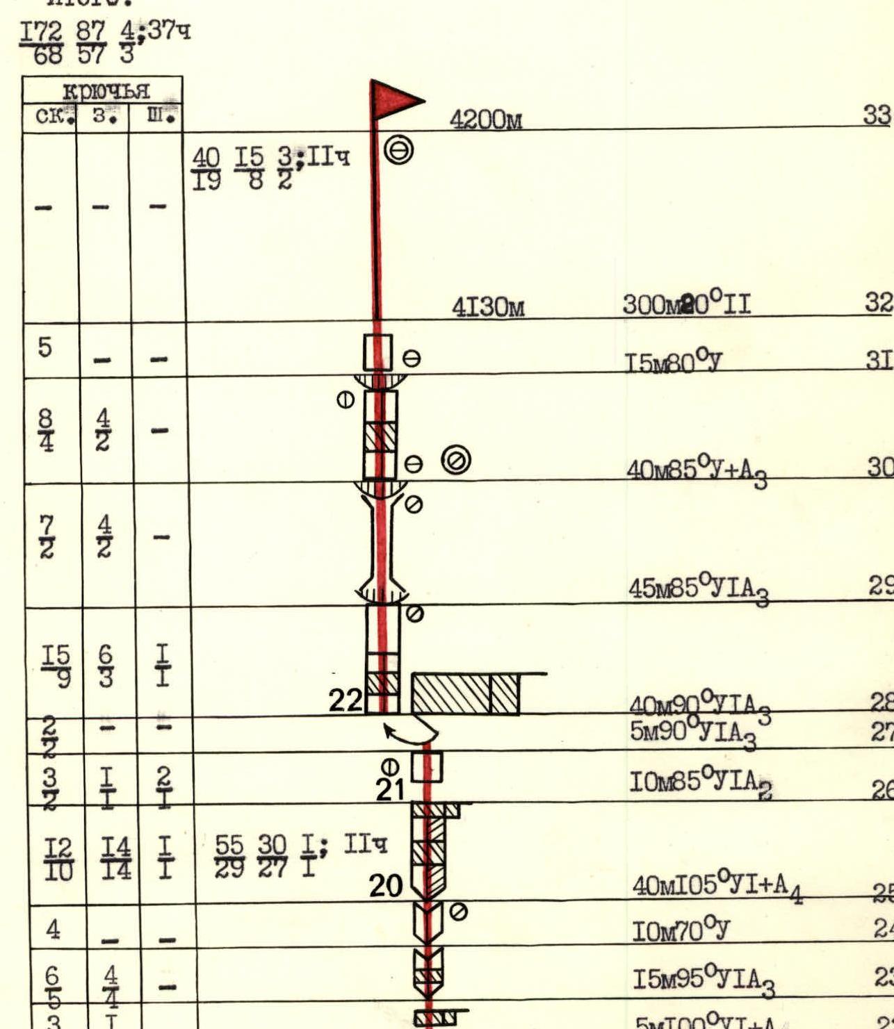
I. Rock class 2. Pamir-Alay, Gissarsky ridge 3. Peak "4200" along the center of the Southeast wall 4. Proposed — 5B category of difficulty, variant 5. Height difference: 630 m, length — 965 m. Length of sections: 5 category of difficulty – 385 m, 6 category of difficulty – 250 m. Average steepness of the main part — 85° (3570–4130), including 6 category of difficulty: 95° (3835–3900), (3915–3935); 97° (3945–3965); 93° (3975–4075) 6. Pitons hammered:
| Rock | Nut | Bolts |
|---|---|---|
| 172/68 | 87/57 | 4/3 |
- Team's working hours — 37 and days — 4
- Overnights: under the route after processing, 1st on the route — lying on a horizontal ledge, 2nd on the route — sitting on an inclined ledge
- Team leader: Vardanyan Valery Vladimirovich
Participants:
- CMS Tonoyan Gayk Danielovich
- CMS Taturyan Grigory Akopovich
- CMS Khachatryan Gagik Norikovich
- CMS Khachatryan Garik Norikovich
- Coach: Harutyunyan Ruben Aykaramovich
- Approach to the route: July 14, 1986 Summit — July 17, 1986 Return — July 17, 1986
- Armenian climbing club "Aragats".
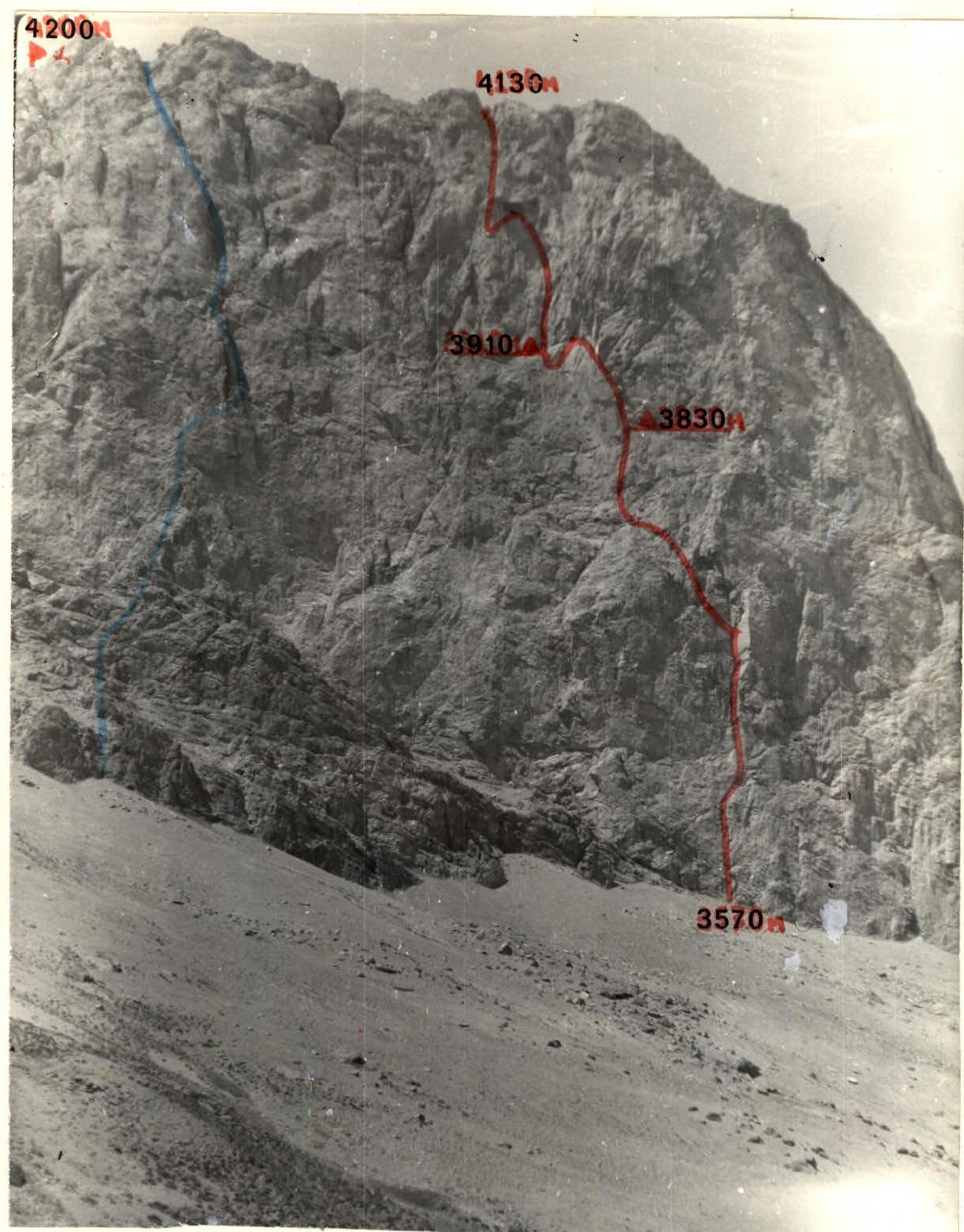
Photo 1.
- V. Glushko's route 1982
- O. Kapitanov's route 1982
- Team's route
The photo was taken on July 15, 1986 at 13:00 from a distance of 1 km at an altitude of 3450 m, shooting point 4, lens Mir-1-A, focal length 3.7 cm.
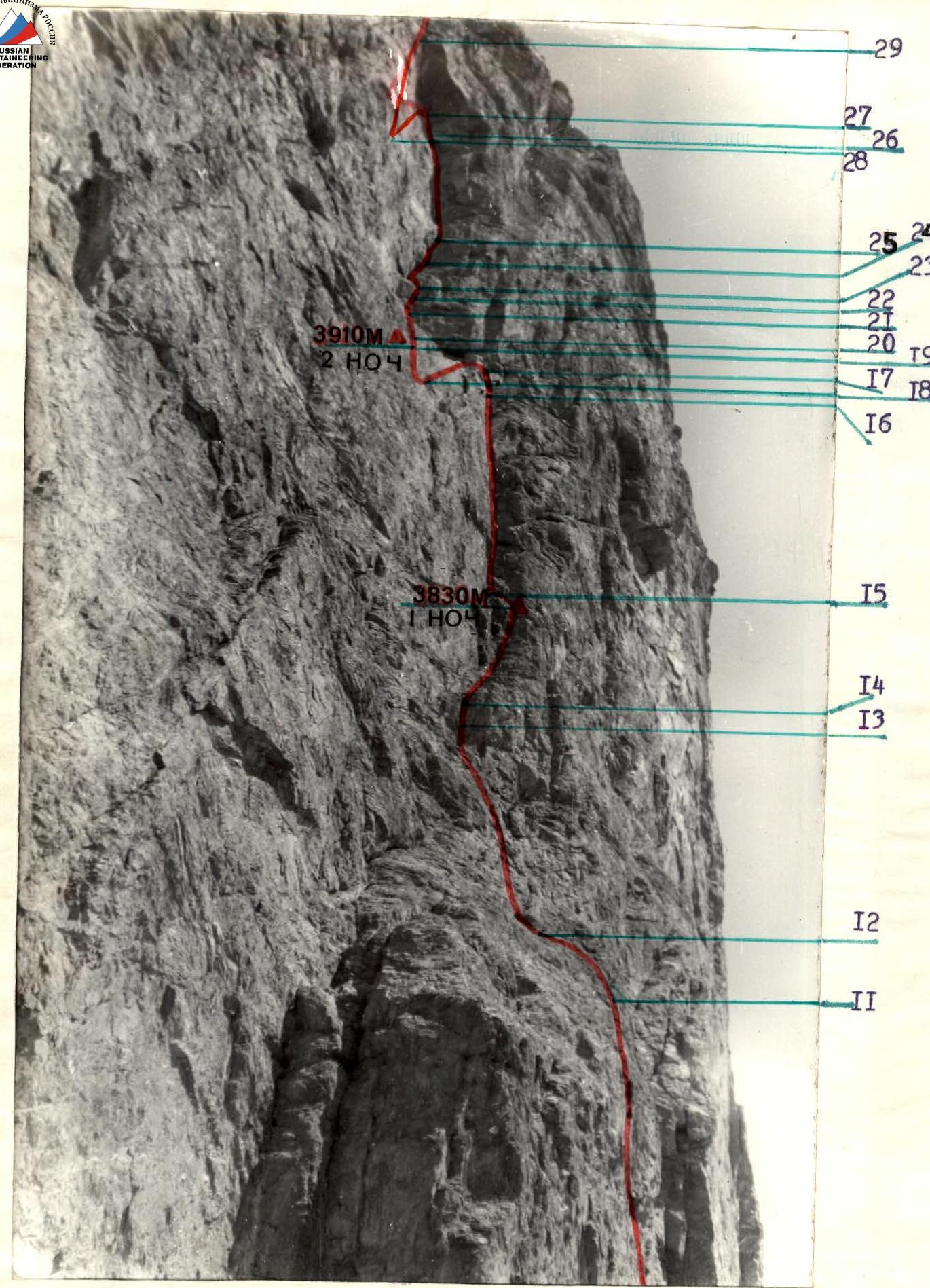
Photo 2. Profile of the SE wall from the right, from the east. The photo was taken from a distance of 200 m at an altitude of 3550 m on July 16, 1986 at 12:00, lens Mir-1-A, focal length 3.7 cm, shooting point 2.

Photo 3. Profile of the SE wall of peak 4200 from the left, from the west. The photo was taken from a distance of 300 m at an altitude of 3670 m. July 16, 1986 at 14:30, shooting point 3. Lens Mir-1-A, focal length 3.7 cm.
Route sections table
| Rock (hammered/left) | Nut (hammered/left) | Bolts (hammered/left) | Length / Steepness / Category | Section |
|---|---|---|---|---|
| 2/2 | 1/1 | – | 20 m 85° V+ | R0 |
| 2/1 | 1/1 | – | 25 m 90° V+A2 | R1 |
| 2/1 | 1/1 | – | 15 m 60° IV | R2 |
| 6/2 | – | – | 10 m 80° V | R3 |
| 3/– | 1/– | – | 30 m 80° V | R4 |
| 4/3 | 1/– | – | 20 m 75° V | R5 |
| 4/– | 2/– | – | 20 m 90° V+A2 | R6 |
| 3/1 | 1/– | – | 10 m 90° V+A2 | R7 |
| 5/– | 5/– | – | 15 m 90° V+ | R8 |
| 5/– | – | – | 20 m 85° V+A2 | R9 |
| 7/– | 3/– | – | 40 m 80° V | R10 |
| 2/– | 1/– | – | 10 m 45° III | R11 |
| 2/– | 1/– | – | 30 m 75° V | R12 |
| 4/1 | 2/– | – | 5 m 90° V+At | R13 |
| 4/– | 1/– | – | 30 m 70° V | R14 |
| 6/– | 2/– | – | 70 m 95° VI+A3 | R15 |
| 3/– | 2/– | – | 10 m 75° V | R16 |
| 2/– | – | – | 5 m 90° V+ | R17 |
| 3/1 | – | – | 20 m 75° V | R18 |
| 5/– | – | – | 5 m 45° V | R19 |
| 6/6 | 4/4 | – | 20 m 95° VI+A3 | R20 |
| 4/– | – | – | 10 m 75° V | R21 |
Total:
| Rock (hammered/left) | Nut (hammered/left) | Bolts (hammered/left) | Length / Steepness / Category | Section |
|---|---|---|---|---|
| 3/– | – | 1/– | 5 m 100° VI+A4 | R22 |
| 4/– | – | 1/– | 15 m 95° VI+A3 | R23 |
| 6/– | – | 1/– | 10 m 70° V | R24 |
| 7/– | 1/– | 1/– | 40 m 105° VI+A4 | R25 |
| 3/2 | 1/1 | – | 10 m 85° VIA | R26 |
| 2/– | – | – | 5 m 90° VL+A3 | R27 |
| 2/– | – | – | 40 m 90° VL+A3 | R28 |
| 15/– | 6/– | 3/– | 45 m 85° VIA3 | R29 |
| 8/4 | 4/2 | – | 40 m 85° V+A3 | R30 |
| 5/– | – | – | 15 m 80° V | R31 |
| 4/– | – | – | 300 m 20° II | R32 |
| – | – | – | – | R33 |
Route description by sections
The route goes through three huge cornices located on the Southeast wall of peak 4200 m in the form of the number "7" and is clearly distinguished by its uniqueness. The beginning (R0–R12) and end (R29–R33) of the route coincide with O. Kapitanov's route. The original part of the route (R12–R29) gave it a more logical and holistic look. Only the exceptional technical difficulty forced Kapitanov's team to make a huge detour, deviate from under the overhanging cornices, and bypass them on the left.
R0–R1: It is a steep cleft with an inclined ledge at the end, followed by a vertical wall with poorly expressed holds, passed by free climbing at the limit of the possible. (Photo 8)
R1–R2: Further — an inner corner covered by a cornice from above. (Photo 7) Climbing is difficult. To exit under the cornice and pass it on the left, ITO ("krukonogi") are used.
R2–R3: After the cornice — an inclined ledge to the base of the chimney. (Photo 7)
R3–R4: The chimney is passed by free climbing. It leads to a steep wall with smoothed holds. (Photo 7)
R4–R5: Up the wall to the left. Difficult climbing on "minutiae" on a monolithic wall.
R5–R6: The wall leads to an inner corner, passed by free climbing. (Photo 7)
R6–R7: The inner corner leads to a large inner corner located under the first huge cornice. A cleft passes through the corner without pronounced holds. Very steep. ITO is used. On such relief, "friends" work well, as well as large-sized nuts. (Photo 9)
R7–R8: The cleft on the right side becomes overhanging, and movement is possible only along the left edge of the inner corner, which is a vertical wall passed by free climbing. (Photo 9)
R8–R9: The wall leads under a huge cornice, which can be bypassed on the left, making a traverse along the wall under the cornice. Since the wall is vertical and without pronounced holds, the traverse is technically very difficult. Climbing is extreme on "minutiae" to a narrow inclined ledge.
R9–R10: From the ledge, up the wall with a narrow crack. Climbing is very difficult and psychological. ITO is used, mainly "krukonogi".
R10–R11: The wall leads to a small "grotto" (Photo 10), where you can rest. Further to the right along the wall, under the canopy, passed in the right part. The holds are well expressed and reliable. Climbing is free and pleasant.
R11–R12: After the canopy, a horizontal ledge is a convenient place for a bivouac. The first control point is located here.
R12–R13: From the ledge straight up along a wide wall to the chimney (Photo 11). The wall gradually becomes steeper, eventually becoming vertical. The holds are reliable. The insurance is piton.
R13–R14: The chimney is passed on the left side using ITO. Climbing is difficult, on balance. (Photo 11)
R14–R15: The chimney leads to an inner corner, passed by free climbing along the right edge. It leads to a horizontal ledge adapted for a bivouac. (Photo 12)
R15–R16: From the ledge straight up along an overhanging inner corner (Photo 13) with a wide (15–20 cm) cleft. The micro-relief of the cleft is very poor, which greatly complicates the passage of the section. Technically, physically, and psychologically, the section is one of the most difficult on the route. (Photo 14) Pre-processing of the section with overcoming it the next day is preferable. Climbing is almost only on ITO using a stance. Wooden wedges and "friends" is successfully applied.
R16–R17: The inner corner becomes flatter, causing significant psychological relief. The relief is rich, and nuts are placed. The corner ends under a large gray cornice with a narrow ledge. (Photo 15) Many loose rocks.
R17–R18: To exit from under the cornice, a traverse-pendulum is used:
- First, a traverse is made to the left along a poorly expressed ledge.
- Then a descent is organized to the level of a narrow ledge (20 m) under the cornice, after which an exit by pendulum to this ledge is made.
R18–R19: Further — a traverse to the left and ascent (Photo 16) by free climbing to a wide inclined ledge. There are few pronounced holds, climbing is on friction.
R19–R20: The ledge is suitable for a sitting overnight stay. A control point is installed on it. (Photo 17)
R20–R21: From the ledge begins an overhanging cleft (Photo 18). Up it to the exit to the inner corner. Climbing is extremely difficult. Movement along the cleft is only on ITO, mainly — on a stance. Horizontal rolled steel angles work very well.
R21–R22: Along the right edge of the inner corner under the cornice-ceiling-potolok. The holds are good, the insurance is piton.
R22–R23: The cornice is passed in the right part. The section is technically one of the most difficult on the route. (Photo 19) Movement is exclusively on a stance. Constantly being thrown off the rock, which leads to increased emotional stress.
R23–R24: Further along the overhanging inner corner with a cleft (5–10 cm) upwards. Climbing is mainly on ITO. The stance is often used. "Friends" work well. The section is rockfall-hazardous, so the belayer should be under the cornice. The rest of the participants can be directly under the cleft of section R20–R21.
R24–R25: The inner corner becomes flatter. Here you can psychologically relax from the constant canopies. Climbing is free, insurance is piton.
R25–R26: The key section of the route is a system of cornices in an overhanging inner corner. (Photo 20) A crack 15–20 cm wide passes through the corner, which is passed exclusively on ITO using wedges. Climbing on ITO is extremely difficult because it is constantly repelled from the rock. All cornices are passed on the left along the way, requiring large expenditures of physical strength. "Zaltsug" is constantly used, and bolt pitons are used. A control point is installed under the cornice at the end of the section.
R26–R27: Further — along a steep smoothed wall without holds under a giant cornice-ceiling-potolok. (Photo 21) Climbing is very difficult on friction using ITO. Bolt pitons are used.
R27–R28: To exit from under the huge cornice, a traverse-pendulum is used:
- A descent is organized to the level of a small ledge (20 m) under the giant cornice, after which an exit by pendulum to this ledge is made.
- Further — by traverse along a sheer wall without clearly expressed holds to the left to the base of a narrow crack. "Krukonogi" are used.
R28–R29: At first — along the crack (Photo 22), then — along a vertical wall without pronounced holds to the left and up to the left edge of the ceiling-potolok under the canopy covering the entrance to the chimney. Climbing is extremely difficult, turning into ITO. A stance is used. Bolt pitons are used.
R29–R30: From under the canopy, an exit to a vertical chimney covered by a cornice from above. (Photo 6) The difficulty of climbing the chimney is extreme. ITO is used. The cornice is passed by tense free climbing.
R30–R31: Along the wall of black color to the right and left along the groove under the canopy. Climbing is difficult, turning into ITO. The canopy is passed using ITO and "Zaltsug". Climbing on ITO is very difficult.
R31–R32: After the canopy — a wall passed by free climbing. It leads to the ridge.
Photo 5. Technical photograph of the route.
The photo was taken on July 16, 1986 at 16:00 at an altitude of 3500 m, shooting point 1, from a distance of 150 m, lens "Jupiter-37A", focal length 13.5 cm.
— overnight stay location.

Photo 6. Technical photograph of sections R13–R32. The photo was taken on July 16, 1986 at 10:00 at an altitude of 3670 m from a distance of 300 m. Shooting point 3. Lens "Jupiter-37A", focal length 13.5 cm. — overnight stay location.
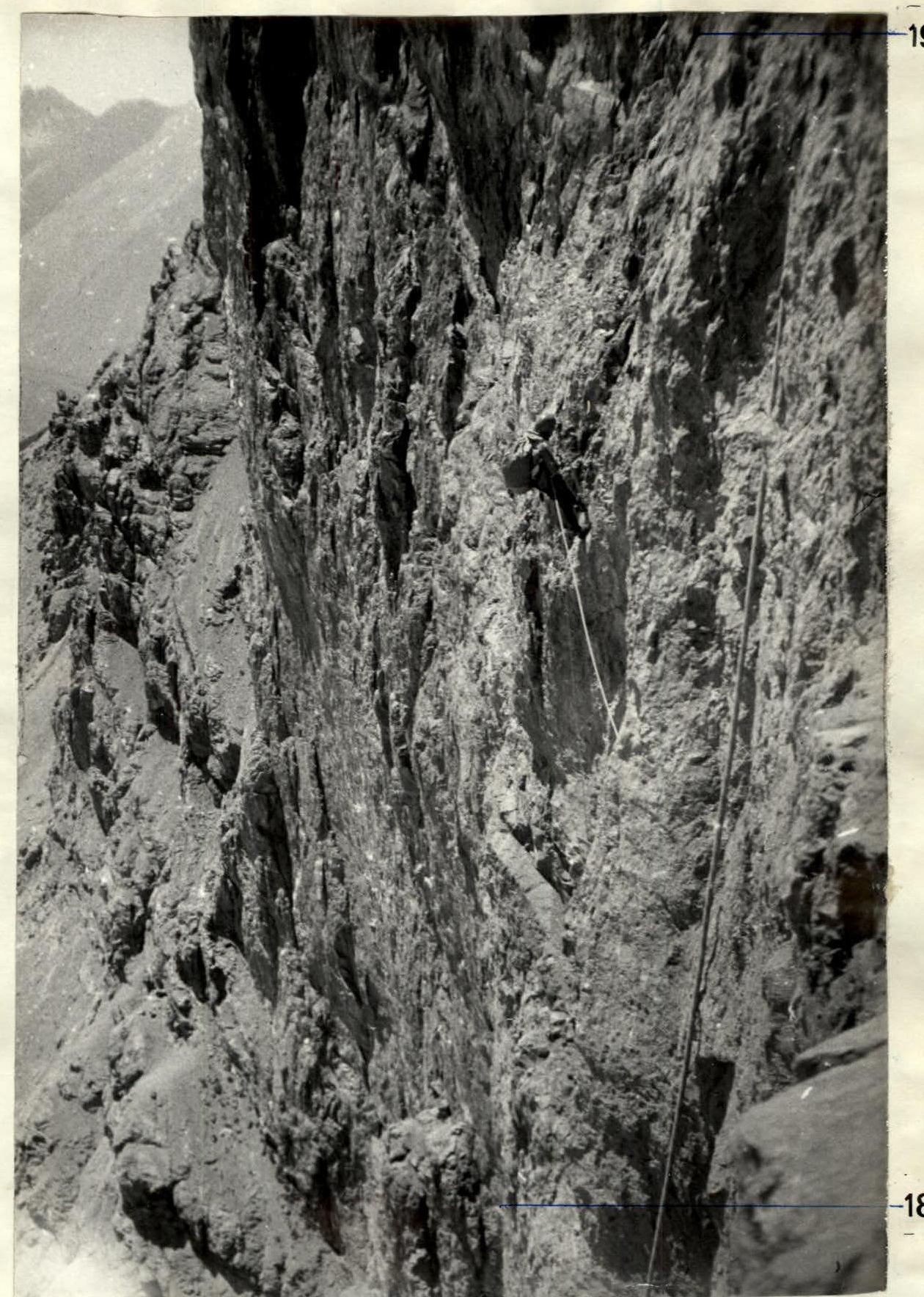
Photo 16. Movement on the rope on section R18–R19. July 16, 1986 at 13:00. Shooting point 16.
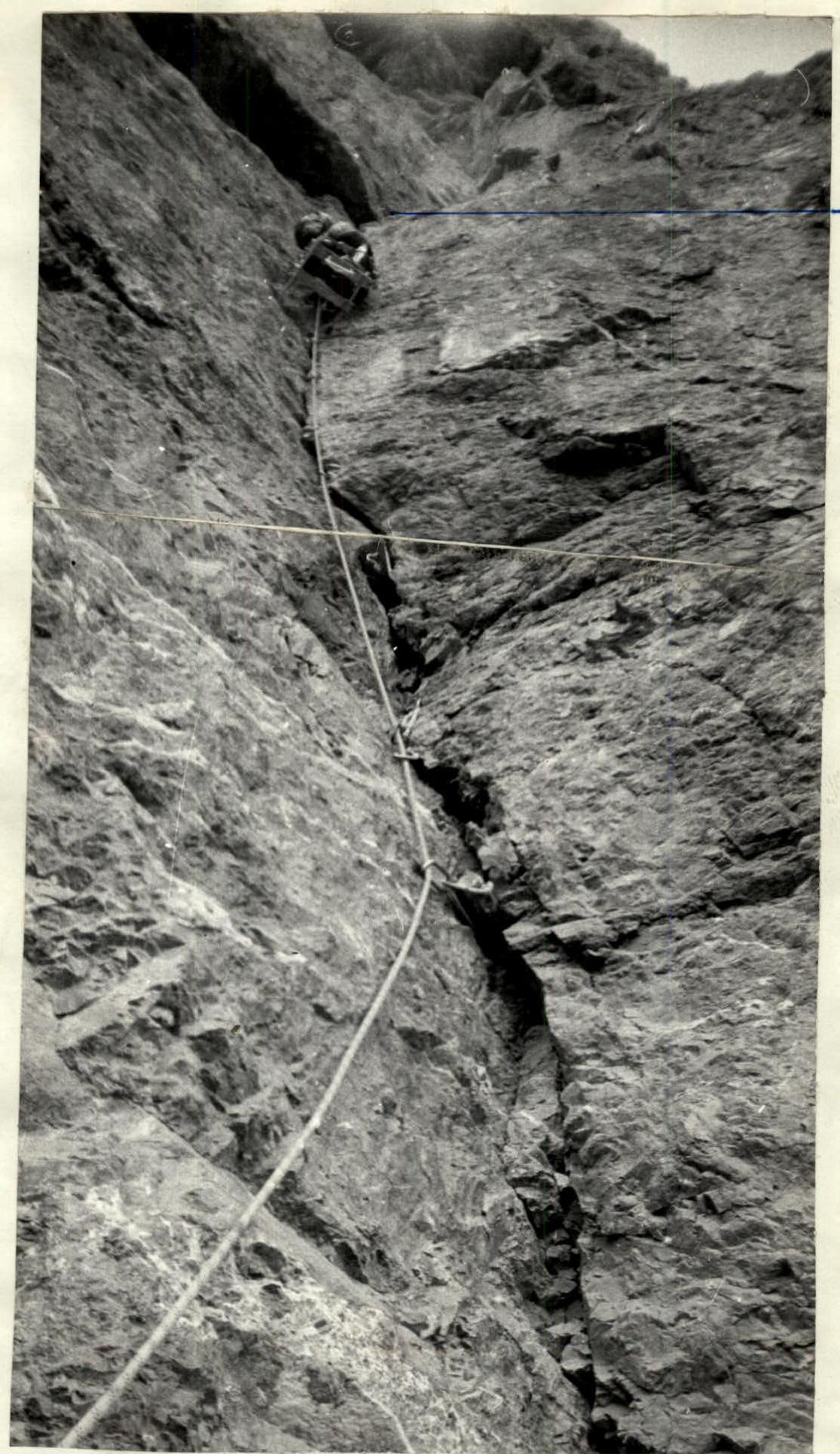
Photo 18. On section R20–R21. Shooting point 18.
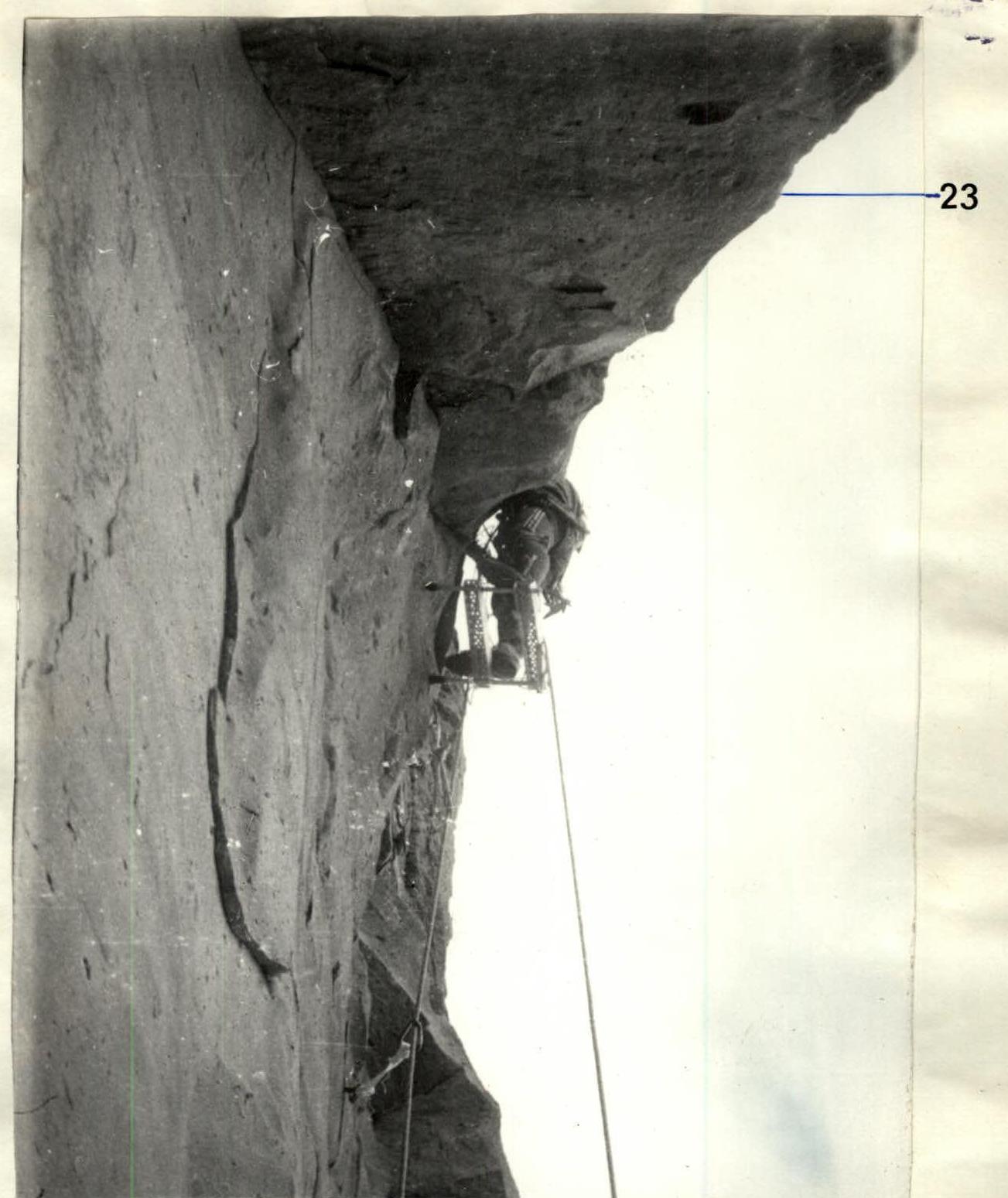
Photo 19. Section R22–R23. Passing the cornice on July 16, 1986 at 16:00. Shooting point 19.