Passport
- Rock class.
- Pamir-Alay, Gissar Range, Tagrich gorge.
- Peak 4200 — southeast wall.
- Proposed 6 cat. sl., first ascent.
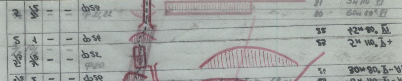
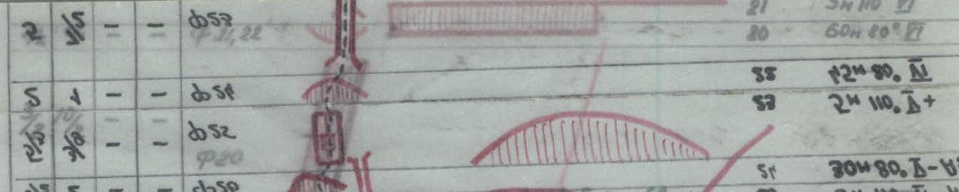
- Route height difference 650 m, wall part — 620 m. Route length — 776 m. Length of sections with 5–6 category complexity — 664 m. Avg. steepness of main sections — 85°. Length of sections with 6 category complexity — 317 m.
- Driven hooks:
| rock | stopper | bolt | ice |
|---|---|---|---|
| 103 | 56 | 5 | 4 |
| 48 | 27 | 6 | 0 |
- Travel hours — 51 h, days 6 (one day of bivy).
- Overnights: I–2 — reclining on an inclined ledge. 3–4 — reclining on a ledge. 5 — sitting on outcrops.
- Leader — Oleg Viktorovich Kapitanov, MS.
Participants:
- Viktor Aronovich Aisenberg, CMS
- Anatoly Stepanovich Skachkov, CMS
- Evgeny Olegovich Lorenz, CMS.
- Coach — Oleg Viktorovich Kapitanov, MS.
- Approach to the route — July 10, 1982.
Summit — July 15, 1982.
Return — July 15, 1982.
(3)

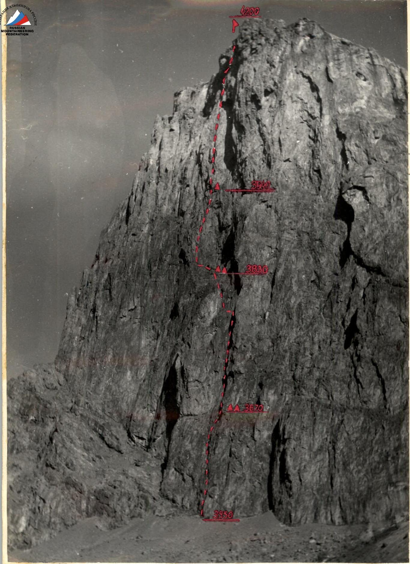
GENERAL PHOTO OF THE SUMMIT. Taken on July 9, 1982, 02:00. T-22 lens, F-75 mm, from
a distance of 1 km, point No. 1. 3200 m
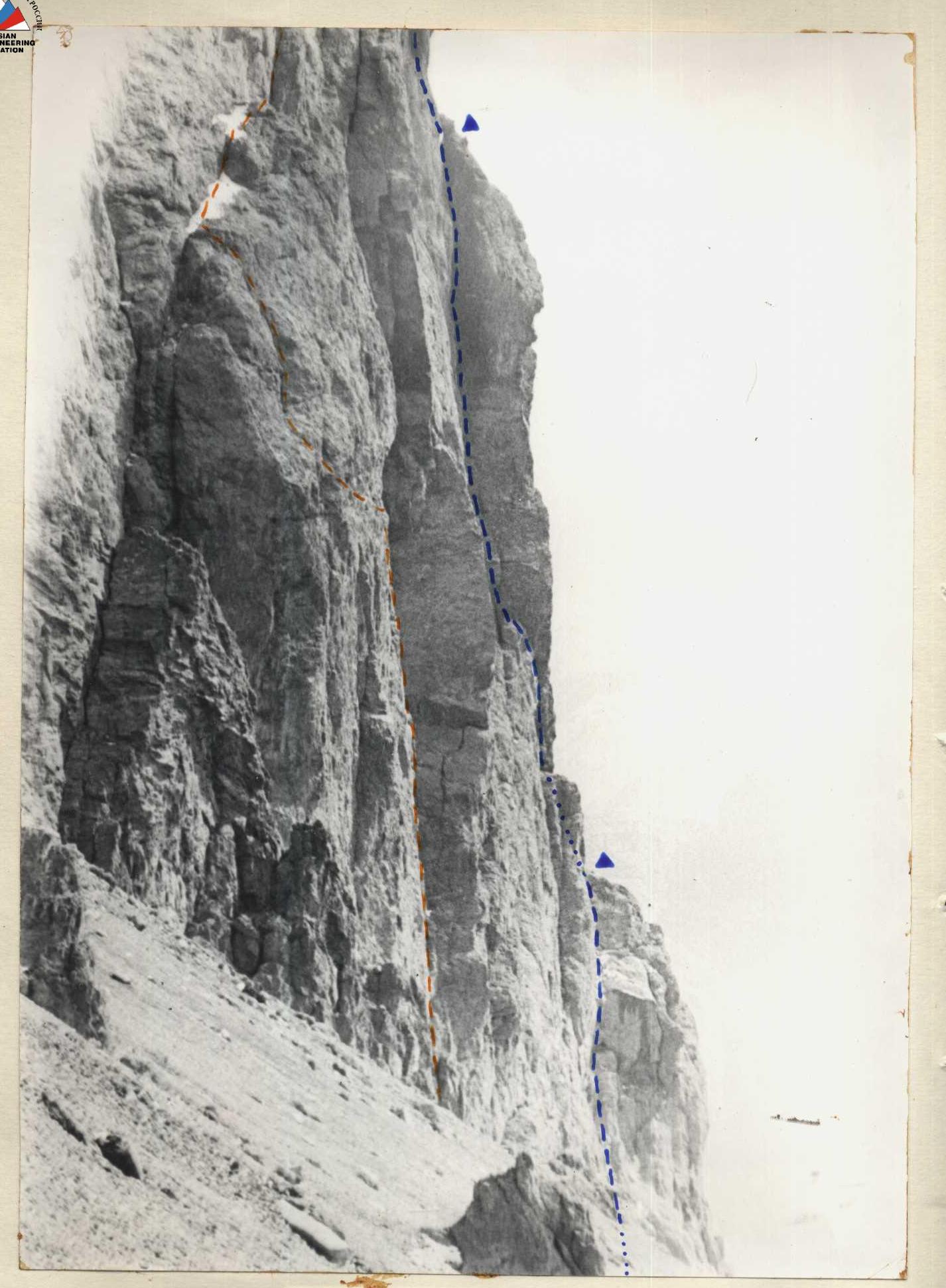
PROFILE FROM THE LEFT
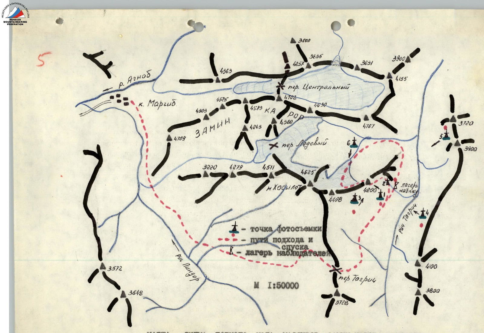
MAP-SCHEME OF THE ZAMIN-KAROR — KHOSILOT MASSIFS MOUNTAIN NODE
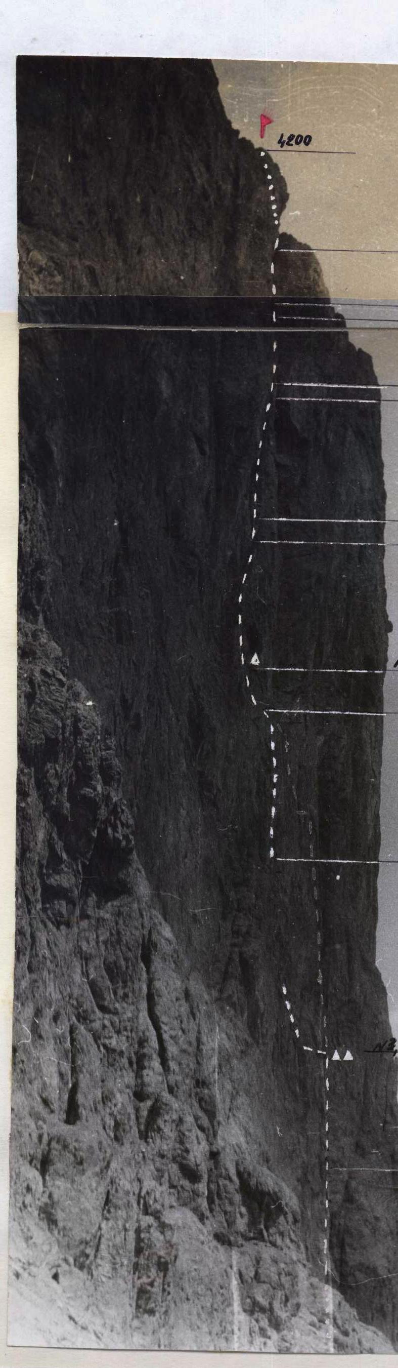
PHOTO OF THE WALL PROFILE FROM THE LEFT
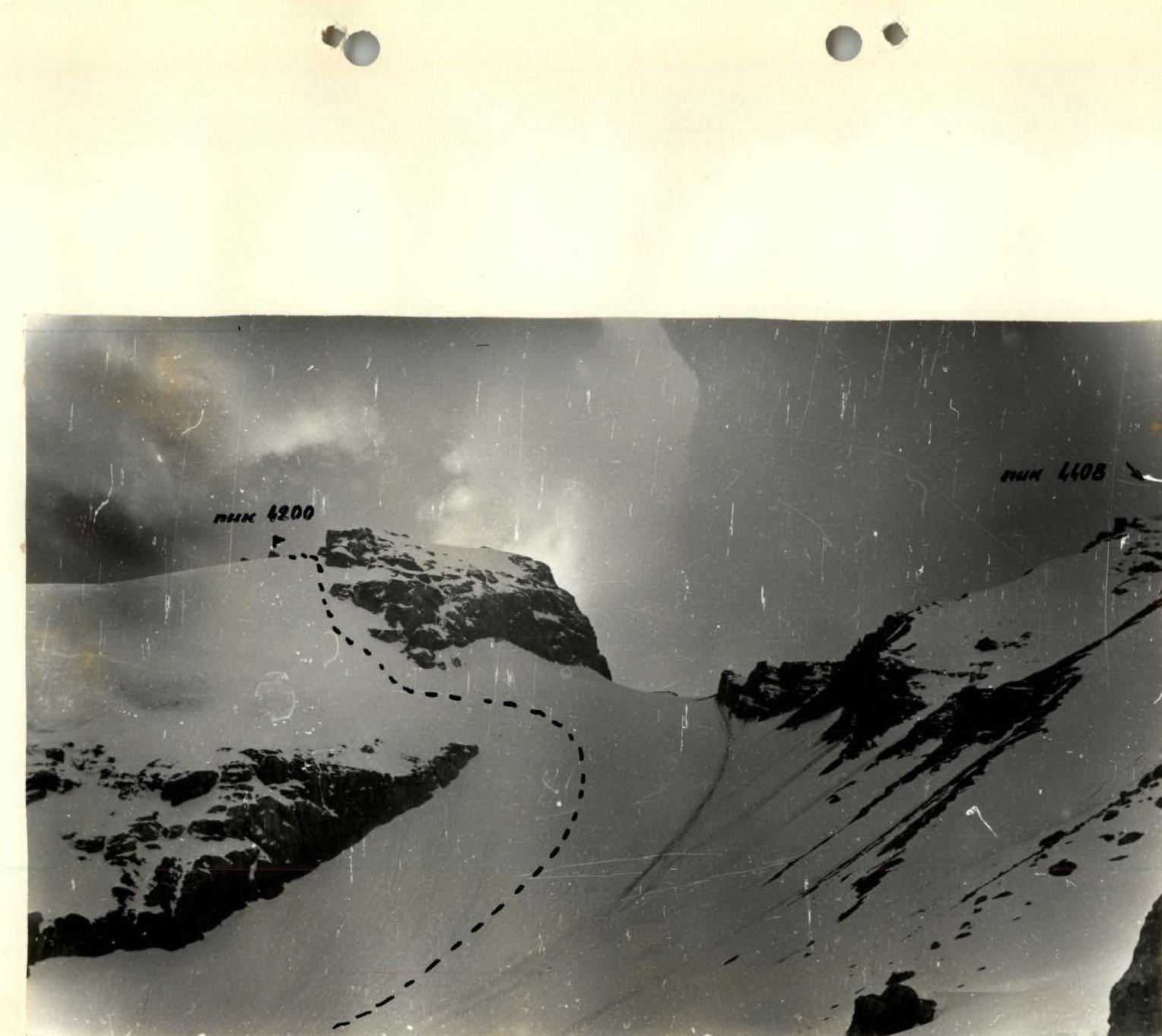
PATH OF DESCENT FROM THE SUMMIT
Brief geographical overview of the area
Peak 4200 is located in the spur of the Gissar Range in the area of the popular mountain massif Zamin-Karor, known in the mountaineering world as the "Yagnob Wall". The summit remained unknown for a long time, as it was obscured from the west by the Khosilot massif. The area around the summit had not been visited before — the attention of mountaineers was focused on the "Yagnob Wall". Finally, the wall was well explored, and with the aim of searching for new routes and objects, a group of instructors from the "Varzob" alpine camp made a hike around the Zamin-Karor massif in July 1981, which discovered Peak 4200. The summit is located in the eastern spur of the Khosilot massif. To the southeast, it is cut off by a sheer wall. To the north — by snowy slopes with rock outcrops. The descent path from the summit to the north is not technically difficult. The height of the peak according to cartographic data varies from 3778 m to 3850 m.
Measurements of the height by an aviation altimeter type NS No. 10692 showed a height of 4200 m. The wall base elevation is 3550 m. The summit can be observed from the Tagrich pass 3770 m.
The approach to the summit begins from the village of Upper Margib, which is located directly under the Zamin-Karor wall. The path from the city of Dushanbe to the village of Margib is well described in the book by S.N. Sogrin "Po marshrutam Pamiro-Aлая" ("Along the routes of the Pamir-Alay").
From the village of Margib:
- along a good, pack trail, bypassing the Western shoulder of the massif (to the right as you go) to the Tagrich pass;
- the trail is known to local residents and shepherds;
- it runs along the left slope (as you go) of the Pindor gorge;
- it takes 3–4 hours to reach the pass from the village.
From the pass, the summit, its southeast wall, is visible. From here to the summit — 1–1.5 hours.
Peak 4200 is composed of dolomites of yellow, red, and gray color. The rocks are monolithic, but there are bands of marbled limestone and shale, which are weak rocks. The routes on the wall are complex, logical, and have clear landmarks. The wall is clad in a strong psychological armor. Not every team can decide to storm it.
The object is promising in terms of sports. The width of the southeast wall is about 1.5 km, the length of the routes is within 600–700 m.
The climate of the area is characterized by continentality and a relatively small amount of precipitation, most of which falls in winter and spring. However, there are exceptions. For example, 1981 and 1982 were characterized by unstable, cold weather with snowfall, which caused the loss of livestock on high-altitude pastures.


 ![img-108.jpeg]({"width":1347,"height":270,"format":"Jpeg","uri":"https://summitx.info/media/1/5zYdPIGxnSUKaRNanDuJD0ZwY↗