
CENTRAL ASIA ALPINISM CHAMPIONSHIP 1983 ROCK CLIMBING CLASS 138
REPORT
on the first ascent to the summit 4200 m via the east-southeast wall, by the team from alplager "Varzob", completed in the period from % to July 2, 1983.
O. Eremin, R. Khairullin, A. Kholontsev
team captain — Alexander F. Khafizov team coach — Oleg V. Kapitanov
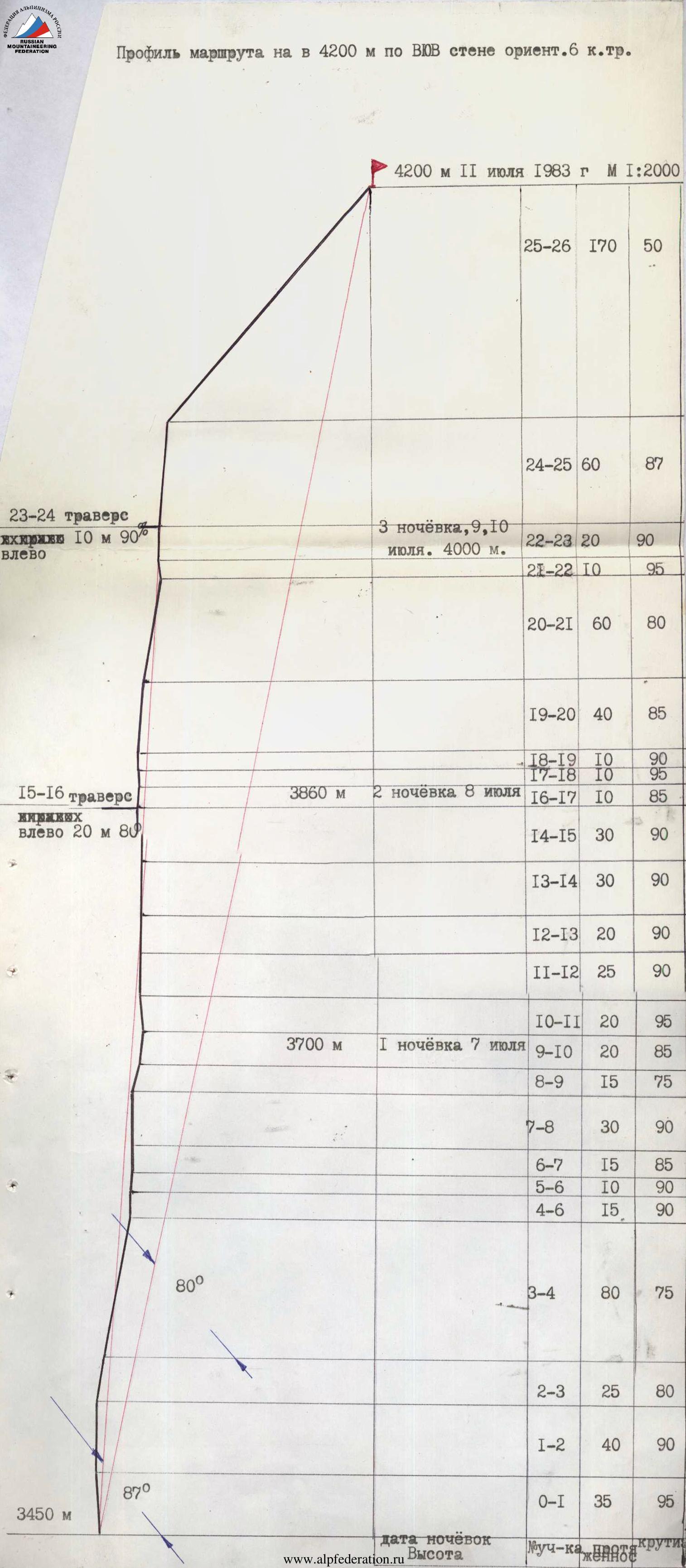
630, 800 m, 185°, VI category of difficulty, 80°, 91 rock pitches, 25 bolts, 48 hours, 5 rappels.
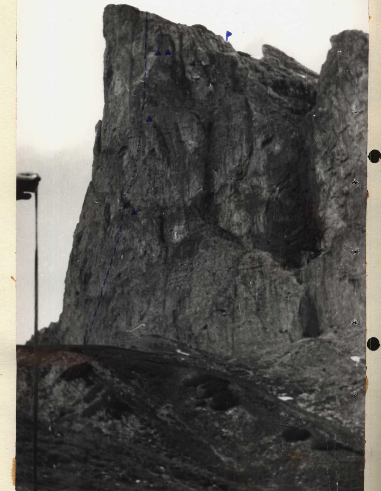
Profile on the right
Addresses:
- alplager "Varzob" — 734003, Dushanbe, P.O. Box 362
- team captain — Khafizov Alexander Faridovich, 450044, Ufa, Komarova St., 26, apt. 23
- team coach — Kapitanov Oleg Viktorovich, 734003, Dushanbe, P.O. Box 362
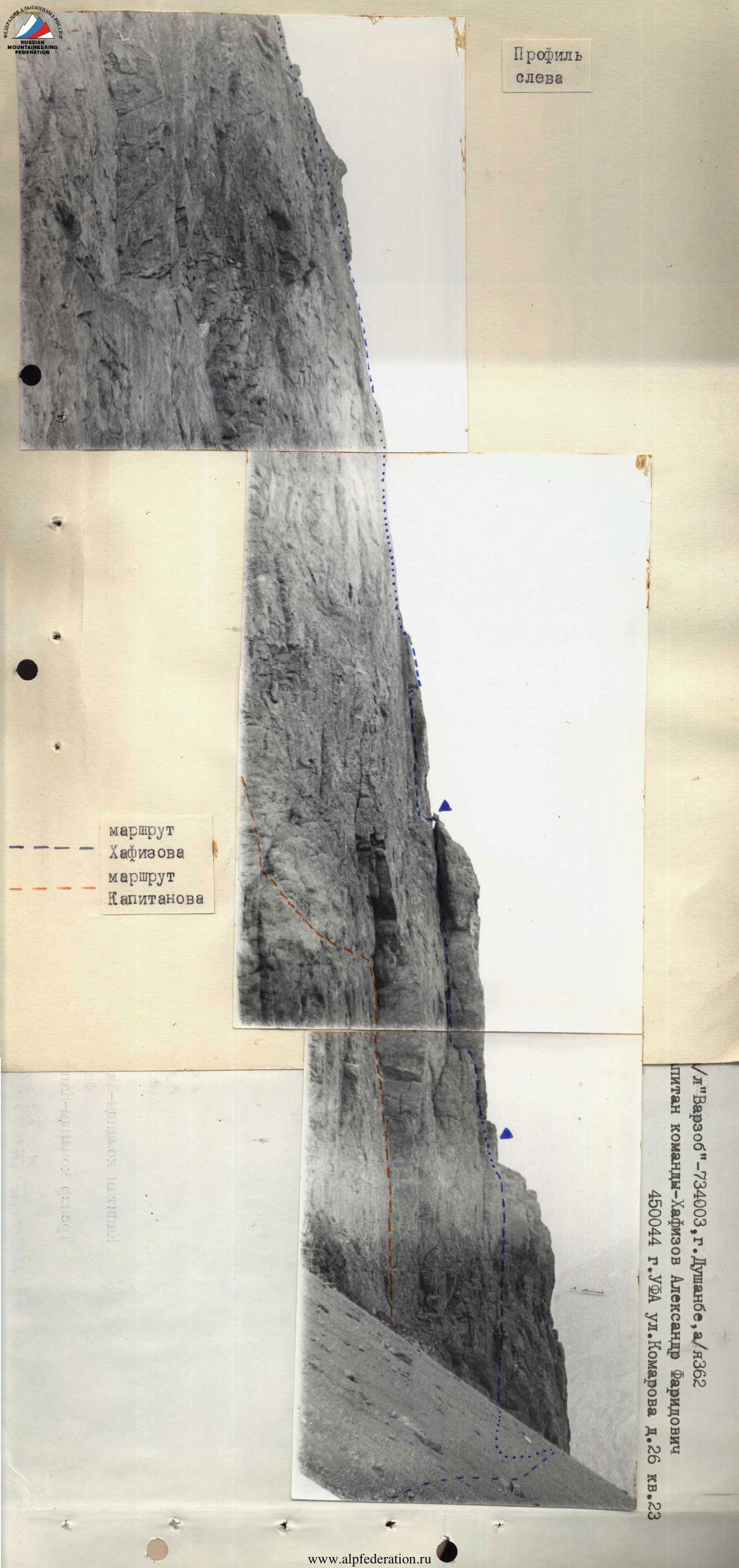
Profile on the left Khafizov's route Kapitanov's route
BRIEF OVERVIEW OF THE ASCENT AREA
The 4200 m summit is located in the Gissar Range, in the southeastern spurs of the Khosilot peak, in close proximity to the popular alpinism area — Zamin-Karor.
The southeast wall of the 4200 m summit is a virtually sheer rock face. In its middle part, the wall has a bend, changing its orientation from SE to ESE.
The nature of the rocks — dolomites, with an outcrop of schist in the middle part of the wall. Rock fractures are oriented downwards, complicating the ascent.
With a relatively small height difference (600–650 m), the walls of peak 4200 m are distinguished by their extraordinary steepness and exceptional monolithicity.
The east-southeast wall of the summit, in terms of height difference and steepness, is comparable to the southeast wall climbed in 1982 via Kapitanov's route, but is even less dissected, especially in its upper part.
The route is laid out virtually vertically and is traversed by free climbing almost everywhere, and also contains places suitable for overnight stays. Water can be found at the second reported bivouac (in an ice-filled chimney).
Climbers rarely visit this area. This is explained by the fact that the Zamin-Karor area, rich in routes, is located nearby.
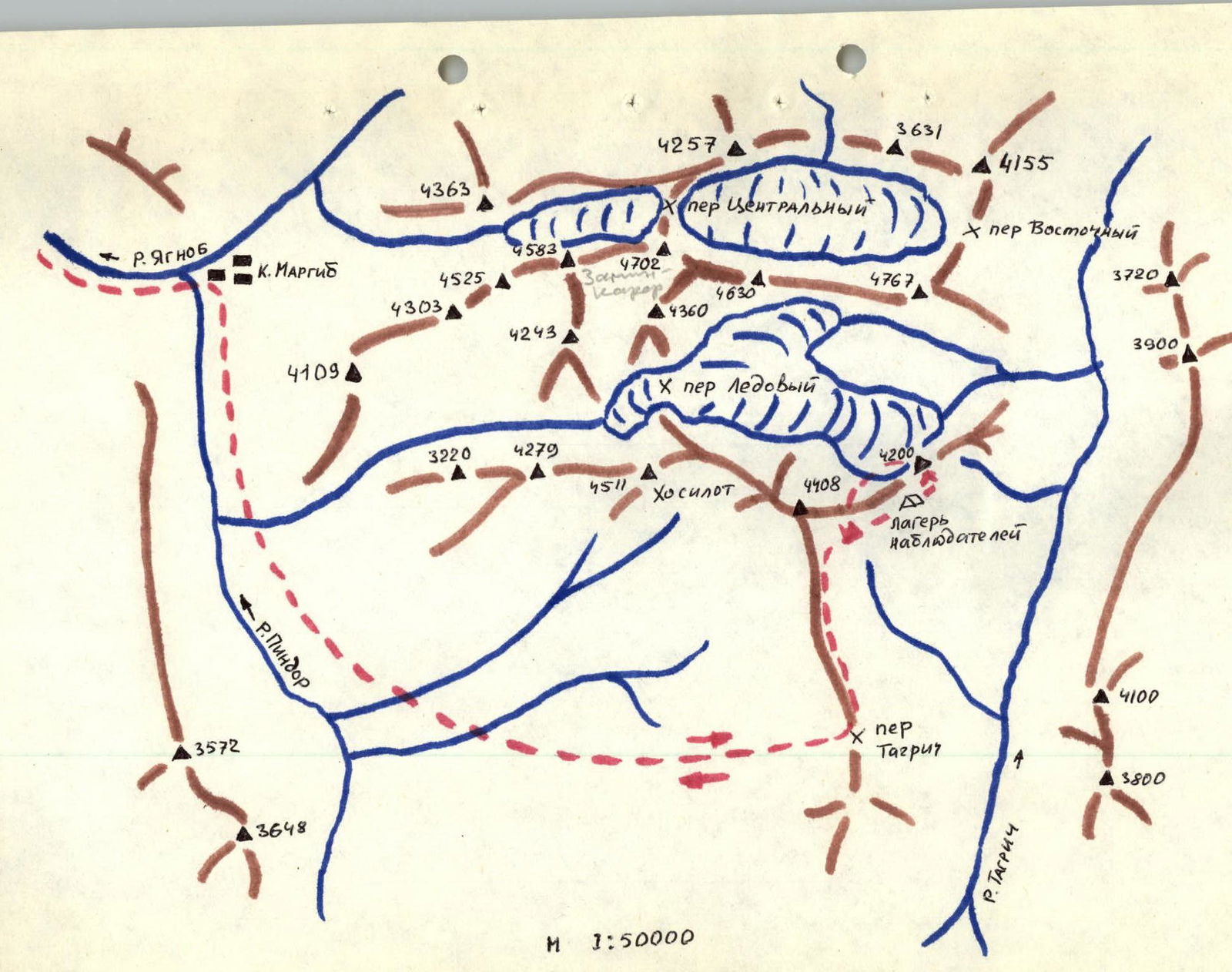
The 4200 m summit is 5 hours' walk from the Margib village. Approach to the ascent object:
- follows the Dushanbe — Leninabad highway
- to the bridge over the Yaghnob river
- then on foot or by car to the Margib village — 5 km
- then ascend along the Pindor river to the Tagrich pass
- then turn left towards the wall of peak 4200
The base camp is recommended to be set up 1.5 km from the wall, near the springs.
DESCRIPTION OF THE ROUTE BY SECTIONS
Section R0–R1 — narrow chimney (overhanging), monolithic walls, with water trickles.
Section R1–R2 — medium sheer chimney with plugs made of live rocks and dripping ice.
Section R2–R3 — slabs alternating with narrow ledges.
Section R3–R4 — narrow inclined ledge, interrupted by small walls.
Section R4–R5 — internal angle with tile-like structure.
Section R5–R6 — narrow chimney (20–30 cm) with a plug.
Section R6–R7 — slab.
Section R7–R8 — internal angle with live blocks.
Section R8–R9 — internal angle (first overnight stay at the beginning of the angle).
Section R9–R10 — wall with a cleft (edges of the cleft are destroyed).
Section R10–R11 — wide crack (5–10 cm), overhanging in the upper part. Edges are heavily destroyed.
Section R11–R12 — internal angle. Water flows down the walls.
Section R12–R13 — narrow chimney (30–40 cm). Dripping ice on the walls in places.
Section R13–R14 — narrow chimney (40–50 cm), rocks are wet, ice.
Section R14–R15 — medium chimney (60–90 cm), filled with ice (ice plugs, icicles), leads to the top of a rock fragment. Second overnight stay.
Section R15–R16 — transition from the rock fragment to the wall (jump and complex traverse 15 m along a sheer 90° wall with micro-holds) to a small ledge.
Section R16–R17 — internal angle, monolithic with micro-holds, no cracks for belay organization. Extremely difficult free climbing.
Section R17–R18 — internal angle with a narrow cleft, walls of the angle are smooth.
Section R18–R19 — wall with slab-like structure, monolith, holds are microscopic.
Section R19–R20 — wall with cavities, leading to a narrow ledge. Sections of free climbing alternate with sections using artificial aids.
Section R20–R21 — internal angle turning into a flake.
Section R21–R22 — smooth monolithic overhanging "forehead" leading to a grotto. Third and fourth overnight stays.
ROUTE IN UIAA SYMBOLS
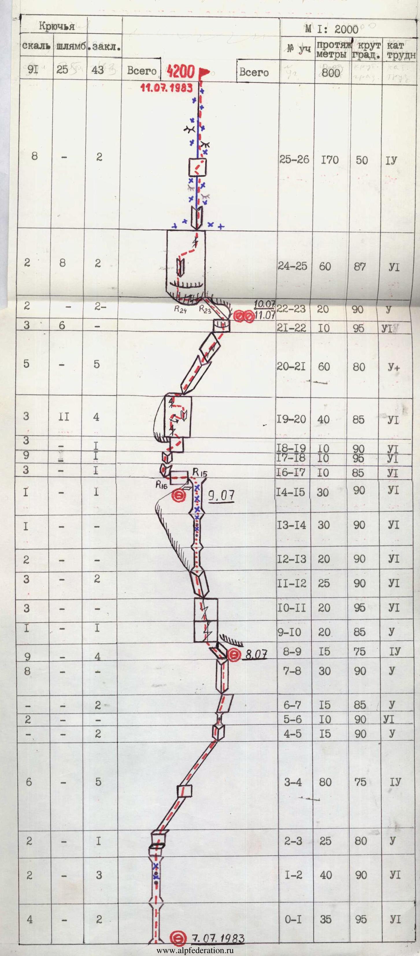
Section R22–R23 — narrow inclined ledge under a cornice, interrupted in two places by 5-meter sheer walls.
Section R23–R24 — traverse along a flake through an overhanging black cornice with a stream. 90°, 15 m, VI category of difficulty.
Section R24–R25 — overhanging monolithic "forehead" turning into a sheer monolithic wall. Extremely difficult free climbing. Some places can only be passed dynamically. No place to stop and rest.
Section R25–R26 — rocky-snow ridge with outcrops of "ram's foreheads", leading to the summit cairn.