ASCENT REPORT
- Ascent type — rock climbing.
- Climbing area — Gissar Range.
- Peak, its height, ascent route — Khodzha-Lokan, 4767 m, South Face.
- Anticipated difficulty category — 5B.
- Route characteristics: a) height difference — 1100 m, b) length of 5B difficulty sections — 525 m, c) average steepness — 70°.
- Pitons driven: a) rock pitons — 162, b) ice pitons — none, c) bolt pitons — 2.
- Total climbing hours — 32 hours.
- Number of bivouacs and their characteristics — three (lying down).
- Climbers' surnames, names, patronymics, and their qualifications: – Grushevsky Valery Grigoryevich, Candidate Master of Sports, – Kozlov Pavel Vladimirovich, Candidate Master of Sports.
- Team coach — Sergey Nikolayevich Sogrin, senior instructor, Master of Sports.
- Date of departure to the route and return: – August 27, 1978 — departure to the route; – August 28, 1978 — work on the wall; – August 29, 1978 — ascent to the summit; – August 30, 1978 — descent from the summit.
South face of Khodzha-Lokan (Dream)
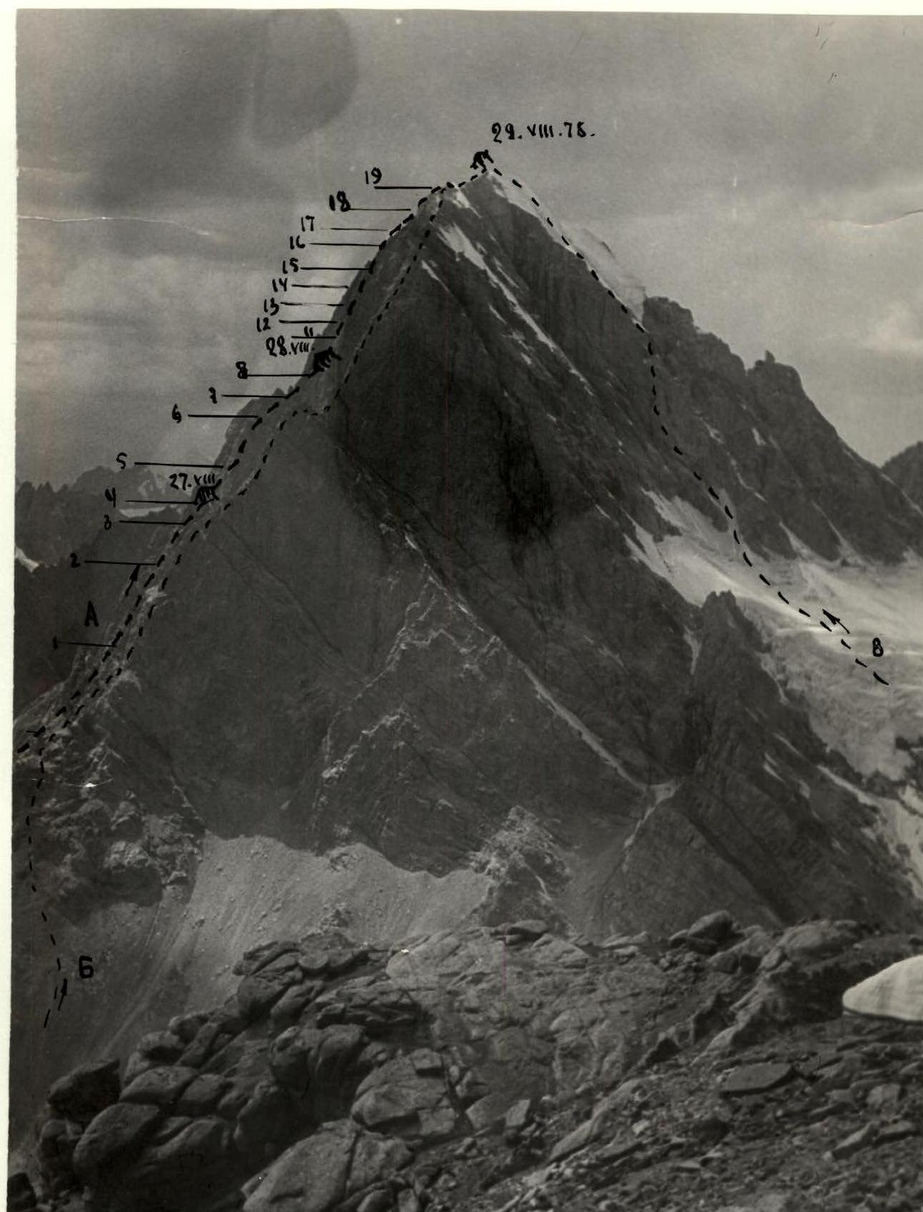
Profile photo of the south face of Khodzha-Lokan (taken from the summit of Festivalnaya) A — ascent route via the South Face. B — classified route via the southeast ridge 5B. C — classified route via the East Face 5A.
Brief description of approaches to the south face of Khodzha-Lokan peak.
The approach to the south face of Khodzha-Lokan peak can be made via various routes:
- Along the Karatag and Pairon rivers. In the upper reaches of the Karatag River, it is called Kadam-Tash.
- Along the Khanaka River and through the Khanaka pass to the Kadam-Tash River valley.
- From the Varzob River gorge along the Sioma River to its upper reaches and through the Chetyrekh pass.
- From the Varzob River gorge along the Maykhura River to its upper reaches and through the Maykhura, Zamok, and Chetyrekh passes.
- From the Varzob River gorge along the Maykhura River, its tributary Yak-Archa, and through the Pastushy, Zamok, and Chetyrekh passes.
Our group moved along the Maykhura River and through the Maykhura, Zamok, and Chetyrekh passes.
The approach from the upper reaches of the Maykhura River to the green meadow in the upper reaches of the Sioma River takes 5 hours, and then through the Chetyrekh pass to the south faces of Khodzha-Lokan — another 6 hours.
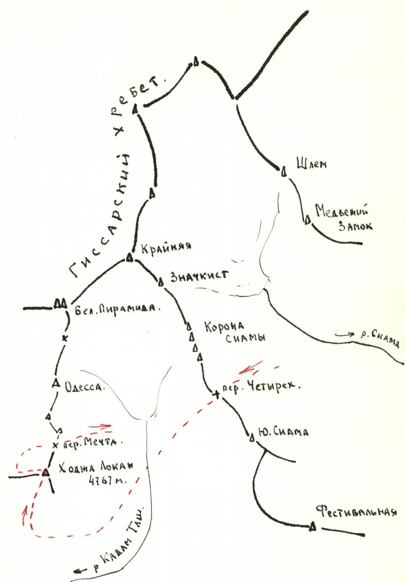
Map of the climbing area.
Route description.
The south face of Khodzha-Lokan peak is a complex massif of granite rocks with numerous walls, towers, couloirs, and shelves on stepped sections.
Characteristic features:
– Funnel-shaped couloirs, which contain snow at the beginning of summer. – Melting snow creates waterfalls that cascade down the couloirs and can significantly complicate the route. – The wall is composed of large monolithic granite blocks. – The group did not detect any signs of rockfall.
From the Chetyrekh pass, it takes 5 hours to descend to the south face. On September 26, 1978, the group set up a bivouac at the foot of the wall on the bank of the Kadam-Tash River. On the same day, they ascended to the southeast ridge of the peak and examined the wall. On September 27, 1978, the approach from the base camp on the Kadam-Tash River bank takes 2 hours.
The path to the lower part of the "funnel" passes along a talus slope, leading to easy rock climbing. Simultaneous movement under the "funnel". After 10 m along the left part of the "funnel" — entrance to the cirque; 3 pitons driven. The "funnel" consists of rocks with smoothed holds, resembling "sheep's foreheads".
Further:
– 60 m left-upward simultaneous movement to the base of a large streak on the wall; – overcome 60 m of easy rock climbing, start ascending left of the streak straight up, 30 m before the ridge; – 20 m along the wall, then move into an internal corner and ascend 40 m along it (10 pitons); – continuing to move along the internal corner, after 15 m, approach the wall composed of slabs (9 pitons).
The wall leads to the upper part of the streak. From here — left to the entrance of a chimney. A challenging section. The rocks are monolithic, with smoothed holds. It is necessary to drive bolt pitons and work on ladders.
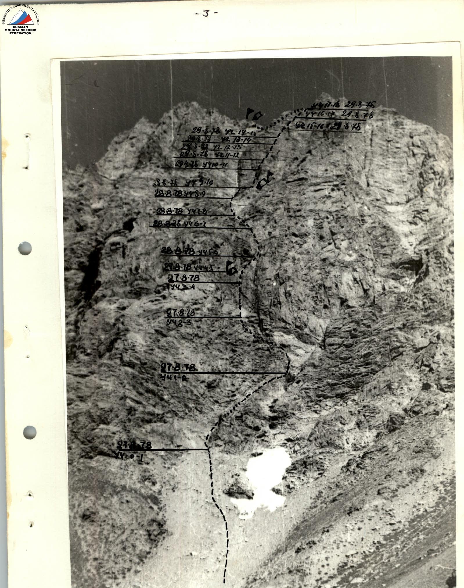
40 m before the chimney, on the left, there is a platform for an overnight stay, where the first control cairn is built. August 28, 1978. From the bivouac, 40 m along the chimney (key section, 12 pitons driven, 2 bolt pitons). The chimney leads to a couloir with high walls, filled with stones. Ascend 120 m up the couloir (15 pitons driven). In the upper part, the couloir widens to 20 m and is divided into two entrances (left and right) by a counterfort descending from above, into corresponding cirques. Keeping to the left part of the couloir, we exit onto the crest of the counterfort. To the right of the counterfort crest, ascend two ropes with moderate difficulty to the right cirque (12 pitons). Crossing the cirque to the right, approach the base of the central counterfort of the central wall, located to the right of a characteristic ice couloir rising upwards for about 200 m. The route passes 60 m to the right of the ice couloir. The central wall is girdled by a shelf composed of black rocks, 1–2 m wide and 60 m long. At the far right end of the shelf, under the protection of rocks, there is a platform for an overnight stay. August 29, 1978. From the bivouac, move left along the shelf under a steep internal corner. Ascend slightly left of the internal corner along a steep wall to a section where the internal corner slightly overhangs (60 m). Ascend the wall to the right-upward to the crest with a steepness of 60° and along it towards a visible chimney from below. Further — onto a "finger" 1 m wide (60 m, 10 pitons). To the right of the "finger", 10 m away, there is a chimney. Continue ascending the chimney with a steepness of 80°. On the right side of the chimney, there is a convenient belay platform for two people. Further along the chimney for 40 m and to the right — exit onto an inclined shelf rising upwards for 20 m (80°, 7 pitons). From the shelf, ascend the wall. The wall consists of yellow-colored slab fragments. After 20 m, an internal corner is visible on the wall, partially turning into a chimney. Ascend 60 m along the internal corner (80°, 12 pitons). The corner leads to a shelf. Along it, 20 m to the right, under a 20 m high wall with smoothed holds. Ascend the wall and again reach a shelf, along which 10 m to the right (50°, 9 pitons). From the shelf, a 30 m wall vertically upwards (60°) leads to a large talus shelf under the summit gendarme. Along this shelf, 30 m to the right, to a small depression between the summit gendarme and the "finger" (5 pitons).
From the depression to the right, a wide couloir is visible, 15 m wide at the bottom and 6–8 m at the top. Ascend 60 m up the couloir (60°, 8 pitons). Further, 50 m to the left along easy rocks to the ridge. From the ridge, bypassing the gendarme along the shelves, in the direction of the summit, three ropes. Reach the summit at 19:00.
We stop for the night on prepared platforms under the summit, and the next morning, we begin descending from the summit along the western ridge.
Table of main route characteristics
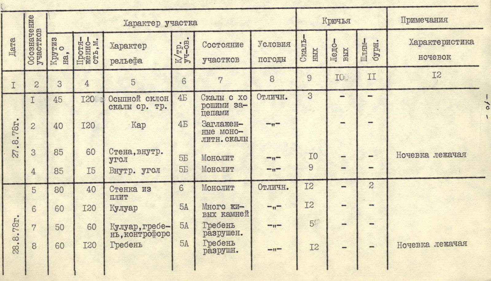
| Date | Designation of sections | Steepness, ° | Length, m | Terrain characteristics | Difficulty category of sections | State of sections | Weather conditions | Rock Pitons | Ice Pitons | Bolt Pitons | Notes Characteristics of bivouacs |
|---|---|---|---|---|---|---|---|---|---|---|---|
| August 27, 1978 | R1 | 45 | 120 | Talus slope, medium-difficulty rocks | 4Б | Rocks with good holds | Excellent | 3 | – | – | |
| R2 | 40 | 120 | Cirque | 4Б | Smoothed monolithic rocks | —//— | – | – | – | ||
| R3 | 85 | 60 | Wall, internal corner | 5Б | Monolith | —//— | 10 | – | – | Bivouac lying down | |
| R4 | 85 | 15 | Internal corner | 5Б | Monolith | —//— | 9 | – | – | ||
| August 28, 1978 | R5 | 80 | 40 | Wall composed of slabs | 6 | Monolith | Excellent | 12 | – | 2 | |
| R6 | 60 | 120 | Couloir | 5А | Many loose stones | —//— | 12 | – | – | ||
| R7 | 50 | 60 | Couloir, ridge, counterfort | 5А | Ridge destroyed | —//— | 5 | – | – | ||
| R8 | 60 | 120 | Ridge | 5А | Ridge destroyed | —//— | 12 | – | – | Bivouac lying down | |
| R9 | 60 | 60 | Couloir | 4Б | Destroyed rocks | Excellent | 3 | – | – | ||
| R10 | 85 | 60 | Wall | 5Б | Monolith | Excellent | 10 | – | – | ||
| R11 | 60 | 60 | Ridge | 5Б | Monolith | —//— | 9 | – | – | ||
| R12 | 80 | 60 | Chimney | 5Б | Monolith | —//— | 11 | – | – | ||
| R13 | 80 | 60 | Chimney, inclined shelf | 5Б | Monolith | —//— | 7 | – | – | ||
| August 29, 1978 | R14 | 80 | 60 | Wall, internal corner | 5Б | Detaching slabs | —//— | 12 | – | – | |
| R15 | 50 | 50 | Shelf, wall, shelf | 5Б | Wall with smoothed holds | —//— | 9 | – | – | ||
| R16 | 60 | 60 | Wall, talus shelf | 5А | Destroyed rocks | —//— | 5 | – | – | ||
| R17 | 60 | 60 | Couloir | 5Б | Monolith | —//— | 8 | – | – | ||
| R18 | 60 | 50 | Wall, ridge | 5А | Destroyed rocks | —//— | 7 | – | – | ||
| R19 | 40 | 180 | Inclined shelf | 4Б | Destroyed rocks | —//— | 18 | Summit bivouac, lying down. |
August 30 descent via the Western Ridge 4A difficulty category.

A — repeat ascent route B — route via the southeast ridge 5B Category of difficulty