REPORT
on the first ascent to the summit of Khamsoya South (Hissar Range) approximately 4A category of difficulty, accomplished on August 24, 1979.
200 m, V–6, 190 m, 65°, 48/5 rock pitons, 7/2 chocks, 17 hours.
Leader: V. M. Goncharenko. Participants:
- V. Yan
- T. V. Kubonina
- S. S. Sobolev
- V. I. Klestov

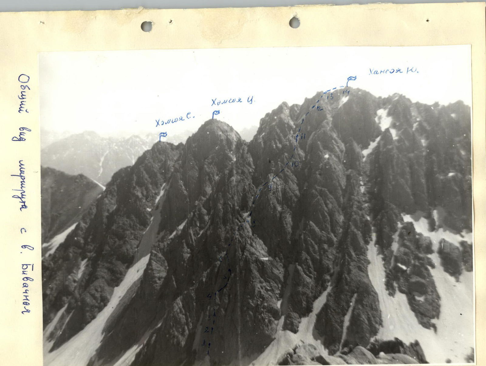
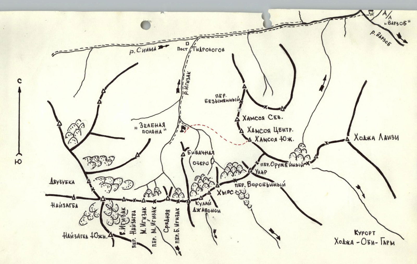
The summit of Khamsoya (3715 m) is located in the southern spur of the Hissar Range, which branches off in a southerly direction, dividing the upper reaches of the Kadam-Tash and Siamy rivers, and then sharply turns east. The eastern end of this ridge drops into the Varzob gorge. In its eastern part is the Igizak area with its namesake gorge. The summit of Khamsoya is situated in a cirque formed, besides it, by the summits of Ular, Khyr's, Kulay Dzhavonon, and Bivaчная. There is a convenient approach to Khamsoya from the "Green Glade" bivouac (1 hour).
There are currently two classified routes to the three summits of Khamsoya (North, Central, South), which are ridge-like in nature:
- a 2B category route to the summit of Khamsoya Central (actually a traverse of Khamsoya South and Khamsoya Central);
- a traverse of all Khamsoya summits, category 3A.
Both routes start from the Nameless pass. Meanwhile, it seems logical to ascend to the summit of Khamsoya South via the Western wall, dissected by couloirs and counterforts. The presence of such a route would naturally complement the existing routes. The counterfort chosen by the group for the first ascent is logical in the sense that it leads to the ridge in the immediate vicinity of the summit. It is quite lengthy. To the left and right, it is bounded by walls on the main part of the route. Thus, bypassing the route, avoiding the control cairn, is practically impossible.
The route appears typical for the area. It is often rocky. There are diverse sections of complex climbing, sometimes using artificial support points. This is especially characteristic of the beginning of the route (sections R0–R1, R1–R2, R2–R3, R3–R4) up to the control cairn. This part of the route is distinctly wall-like and passes through smooth slabs with few holds.
The report on the first ascent is compiled in accordance with the regulations on route classification. It contains the following points:
| №: | Name | № of item according to regulations | page |
|---|---|---|---|
| 1 | Passport | 3.3.1.1. | 3 |
| 2 | Photo of the summit | 3.3.1.2. | 3 (on back) |
| 3 | Map of the area | 3.3.1.3. | 5 |
| 4 | Brief description of the approach | 3.3.1.4. | 6 |
| 5 | Table | 3.3.1.5. | 7 |
| 6 | Explanation to the table. Route description | 3.3.1.6. | 8–9 |
General view of the route from the summit Bivaчная.
Scheme of Igizak area.
Table
of the main characteristics of the ascent route to Khamsoya South via the counterfort of the western wall
| Date | Section | Character of the section: average steepness in degrees | length in meters | Character of relief | Difficulty | Condition | Weather conditions | Pitons: rock | chocks |
|---|---|---|---|---|---|---|---|---|---|
| 24.08 | R0–R1 | 80° | 40 m | Wall | 5 | monolith | good | 6 | 2 |
| R1–R2 | 90° | 40 m | Wall with overhang and slot | 6 | smoothed monolith | 8 | 2 | ||
| R2–R3 | 80° | 40 m | Smoothed slabs | 4 | slabs | 5 | |||
| R3–R4 | 65° | 30 m | Wall, inclined slab | 4 | slabs, blocks | 3 | |||
| R4–R5 | 50° | 80 m | Ridge | 3 | blocks | ledges | |||
| R5–R6 | 80° | 40 m | Slot, chip | 4 | monolith | 3 | 3 | ||
| R6–R7 | 40° | 80 m | Narrow ledge | 4 | monolith | 2 | 2 | ||
| R7–R8 | 80° | 30 m | Wall | 5 | monolith | 5 | |||
| R8–R9 | 60° | 80 m | Ridge | 3 | destroyed | ledges | |||
| R9–R10 | 75° | 80 m | Wall with ledges | 5 | monolith | 8 | |||
| R10–R11 | 60° | 80 m | Wall | 4 | monolith | 6 | 2 | ||
| R11–R12 | 50° | 80 m | Ridge | 2 | destroyed | ledges | |||
| R12–R13 | 60° | 80 m | Inner corner | 3 | monolith, loose rocks | 2 | |||
| R13–R14 | 40° | 160 m | Ridge | 3 | blocks, monolith, loose rocks | ledges |
Route description
to the summit of Khamsoya South via the counterfort of the western wall. Explanation to the table.
From the "Green Glade" bivouac, follow along the stream flowing from the cirque of Kulay-Dzhovanon summit. Cross the stream and exit under the slopes of South Khamsoya summit. The route begins from the characteristic rock gate with a chimney in the right part, cutting through the wall. The landmark on the right is the black wet rocks, on the left - a vaguely defined grassy couloir, located to the right of the large snowy couloir.
Up the smoothed slabs to the left of the chimney, 40 m to an overhanging rock. Belay is piton. From the chimney, traverse pendulum-like to the right, 5 m "very difficult!" to a vertical slot and up it, 15 m. The edges of the slot are smoothed and have virtually no holds; the slot is overcome by friction. Then up to the right along the smoothed wall without holds, 20 m to a small platform. Climbing is complex. The next section is 40 m up the smoothed slabs to a small platform under an arch. From here, along inclined slabs to the left and up, 30 m to a shoulder. On the shoulder is a control cairn. Overnight stay is possible. From the control cairn, 80 m along the ridge (rocks of medium difficulty). The further path passes to the left of the ridge along a narrow ledge, 20 to 50 cm wide. Belay! The ledge is 120 m long and passes under sheer rocks. At the end, it widens and leads to a platform where a bivouac can be organized.
From the platform up to the ridge, 30 m of complex climbing along the wall (pitons!). The best option is along the crack and the right part of the wall. On the ridge is a characteristic pointed gendarme in the form of a reddish spade. From it, along the ridge, 80 m along rocks of medium difficulty to the next gendarme, inclined to the left. This gendarme and the next two are bypassed by traversing to the right along ledges. The counterfort ridge leads under the walls of the main ridge of the summit. The exit to it is made along an inner corner, 80 m long. Rockfall hazard! After exiting onto the ridge, 160 m to the right along easy rocks to the summit of South Khamsoya. To descend from the summit, continue along the ridge to the south to a characteristic black gendarme in the form of a tooth. From the gendarme, descend to the right along a couloir. In the lower part, the couloir ends in a sheer wall. Therefore, when moving along the couloir, stick to its right side and cross over to the right neighboring couloir, which leads to the moraine under the summit. Along the stream, descend to the valley to the bivouac.
The ascent takes 17 hours.
Profile of the route.
