- Class of ascent — rock climbing
- Ascent area — Gissar Ridge
- Peak, its height, ascent route — p. Festivalnaya, 4350 m via the Left northern counterfort.
- Estimated difficulty category — 3B.
- Route characteristics: a/. Height difference — 400 m; b/. Length of sections with 4A category difficulty – 145 m; c/. Length of sections with 3B category difficulty – 370 m; d/. Average steepness — 50°.
- Number of pitons driven: a/. Rock pitons — 19; b/. Ice pitons — none; c/. Bolt pitons — none.
- Number of travel hours — 8 hours.
- Number of overnight stays and their characteristics — none.
- Surname, first name, patronymic of participants, their qualification: a/. Oganesov Artem Oganesovich — 1st sports category; b/. Tursunov Yuldash Abdurakhmanovich — 1st sports category.
- Coach — Sogrina Emma Grigoryevna, senior instructor, Master of Sports.
II. Date of departure on the route and return — August 25, 1978, 6:00 — departure on the route from the base camp under p. Zamok. August 25, 1978, 19:00 — return to the base camp.
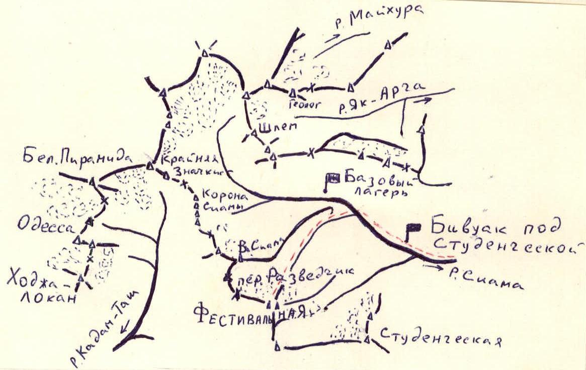
From the Varzob gorge, where the Varzob tourist center is located, ascend along the Siama River. Having passed the bivouac under Studencheskaya, cross to the right (orographic) bank of the Siama River via a snow bridge and ascend along the Festivalny stream to the left moraine of the glacier, where there are areas for overnight stays. From the overnight stays, the entire ascent route is clearly visible. To the right of the counterfort lies an ice-snow couloir ascending to the saddle on the pre-summit ridge, where rocks and small avalanches may fall. To the right of this couloir is the northern edge, along which a 4A category difficulty route passes. Leaving the ice-snow couloir to the right, approach the base of the left northern counterfort. The approach takes 10 hours.
Start of the route:
- A steep couloir with notched rocks narrows at the top, turning into a chimney that leads to a small ledge on the northern counterfort (section R0–R1).
- Climbing is difficult, 60 m, piton belay. 5 pitons driven.
- Attention! There are many loose rocks on this section!
- To the left lies an ice-snow couloir. Movement along the couloir is not recommended — it is hazardous due to possible rockfall!
Further on, a "finger" is visible, serving as a landmark for the direction of movement.
- Move left along the ledge, then up a 5 m wall, which is initially steep (but has good holds) — to reach a ledge.
- Along the ledge, approach a small wall.
- The wall leads to an internal corner on the right side along the direction of movement.
- The 5 m internal corner leads to a ledge under the "finger" (section R1–R2).
- Leaving the "finger" to the right, 40 m along a sheer red wall along a ledge — ascent to an internal corner.
- Under the red wall — a control cairn (section 2–3).
The 20 m internal corner consists of two parallel sheer chimneys:
- The right chimney has sheer, smooth walls.
- The left chimney is blocked at the top by a "cork".
Technique for passage:
- Initially, ascend the right chimney for 2–3 m.
- Then move to the left chimney.
- 2–3 m before reaching the "cork", move back to the right chimney.
- Ascend the right chimney to a ledge.
- Piton belay (section 3–4).
Further on:
- Up the couloir, along simple, destroyed rocks — to characteristic rocks with black streaks.
- The black rocks are bypassed on the left along destroyed, scree-covered ledges — 60 m.
- Then, along slabs and heavily destroyed rocks, 60 m upwards — leading to a ridge.
- To the right lies a characteristic tooth. 4 pitons driven (section 4–5).
- Along rocks with good holds, 70 m upwards — to a notch in the ridge (section 5–6).
- Further, 180 m along the ridge on monolithic rocks with good holds — exit onto the northeastern ridge (section 6–7).
- Then, along the northeastern ridge on simple rocks — 25 minutes to the summit.
Descent from the summit:
- Along the ridge to the west on simple rocks and snow — to Razvedchik pass.
- From the pass, on snow and scree slopes — descend to the moraine.
General information:
- The ascent takes 13 hours from the bivouac under p. Zamok.
- The route is rated 3B category difficulty.
- The route is recommended for a well-prepared sports team.
Main characteristics of the route
| Date | Designation | Average steepness, degrees | Length, m | Terrain characteristics | Difficulty | Condition of sections | Weather conditions | Rock pitons | Ice pitons | Bolt pitons |
|---|---|---|---|---|---|---|---|---|---|---|
| 25.08.1978 | 1 | 75 | 60 | Wall, chimney | IV | many loose rocks! | good | 5 | – | – |
| 2 | 65 | 60 | Walls, internal corner | IV | monolithic | –"– | 4 | – | – | |
| 3 | 20 | 40 | Ledge | II | destroyed ledge | –"– | – | – | – | |
| 4 | 80 | 25 | Chimney | IV | smooth monolithic rocks | –"– | 4 | – | – | |
| 5 | 50 | 120 | Couloir, scree ledges, slabs | III | destroyed rocks | –"– | 4 | – | – | |
| 6 | 50 | 70 | Wall | III | rocks with good holds | –"– | 2 | – | – | |
| 7 | 45 | 180 | Ridge | III | monolithic | –"– | – | – | – | |
| 8 | 30 | 360 | Ridge | II | rocks destroyed | –"– | Belay on outcrops | – | – |

Section 4

Section 5