ASCENT DOCUMENT (SECOND ASCENT)
-
ASCENT CLASS — TECHNICAL
-
ASCENT REGION — Gissar Ridge, Sangalta area
-
ASCENT ROUTE — Peak Tu 3640 m via SE edge
-
PROPOSED DIFFICULTY CATEGORY — 5B
-
ROUTE CHARACTERISTICS:
Length 1200 m, height difference 850 m, average steepness 57°. Length of sections P.TR. – 20 m, Ш.TR. – 220 m, 1U – 450 m, U – 500 m. Steepness 83°. Number of driven pitons: for rock belay — 78, wooden wedges — 3.
-
MOVING TIME — 13 hours
-
NUMBER OF OVERNIGHTS — none
-
GROUP COMPOSITION:
1/ Ordin A.V. "Zenit" — leader, 1st sports category 2/ Varshavsky P.T. — participant, II category 3/ Perevalov S.P. — participant, II category 4/ Kardapolov G.V. — participant, II category 5/ Zhavoronkov A.A. — participant, II category
Team coach — Martyusheva V.A., Master of Sports
- ASCENT DATE — September 15, 1978
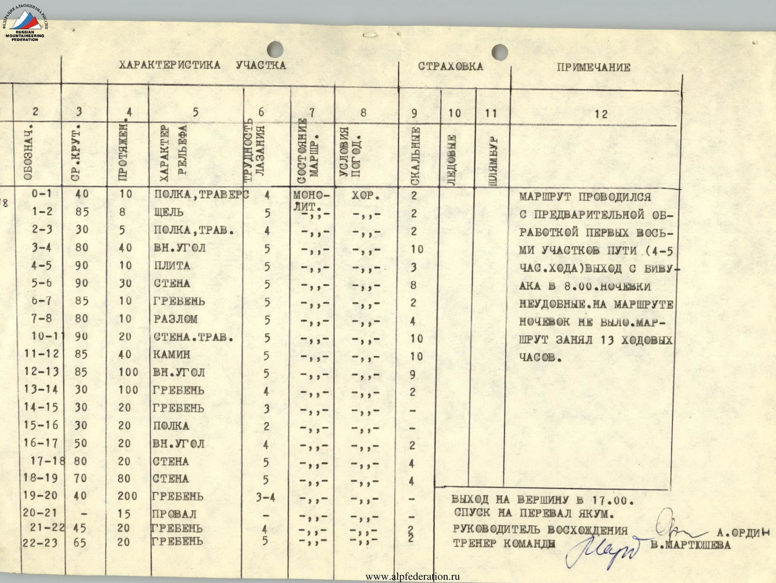
Section Characteristics
Belay
| Notation | Avg. Steep. | Length | Terrain Character | Climbing Difficulty | Route Condition | Weather Conditions | Rock | Ice | Bolt | Remarks |
|---|---|---|---|---|---|---|---|---|---|---|
| R0–R1 | 40 | 10 | Shelf, traverse | 4 | mono- | good | 2 | The route was done with preliminary processing of the first eight sections (4–5 hours of walking). Departure from the bivouac at 8:00. Uncomfortable overnight stays. There were no overnight stays on the route. The route took 13 hours of walking. | ||
| R1–R2 | 85 | 8 | Crack | 5 | lit. | 2 | ||||
| R2–R3 | 30 | 5 | Shelf, trav. | 4 | 2 | |||||
| R3–R4 | 80 | 40 | Inner corner | 5 | 10 | |||||
| R4–R5 | 90 | 10 | Slab | 5 | 3 | |||||
| R5–R6 | 90 | 30 | Wall | 5 | 8 | |||||
| R6–R7 | 85 | 10 | Ridge | 5 | 2 | |||||
| R7–R8 | 80 | 10 | Fault | 5 | 4 | |||||
| R10–R11 | 90 | 20 | Wall, trav. | 5 | 10 | |||||
| R11–R12 | 85 | 40 | Chimney | 5 | 10 | |||||
| R12–R13 | 85 | 100 | Inner corner | 5 | 9 | |||||
| R13–R14 | 30 | 100 | Ridge | 4 | 2 | |||||
| R14–R15 | 30 | 20 | Ridge | 3 | ||||||
| R15–R16 | 30 | 20 | Shelf | 2 | ||||||
| R16–R17 | 50 | 20 | Inner corner | 4 | 2 | |||||
| R17–R18 | 80 | 20 | Wall | 5 | 4 | |||||
| R18–R19 | 70 | 80 | Wall | 5 | 4 | |||||
| R19–R20 | 40 | 200 | Ridge | 3–4 | Reached the summit at 17:00. Descent to Yakum pass. Ascent leader — S. Ordin, Team coach — V. Martyusheva | |||||
| R20–R21 | 15 | Drop | ||||||||
| R21–R22 | 45 | 20 | Ridge | 4 | 2 | |||||
| R22–R23 | 65 | 20 | Ridge | 5 | 2 |
Description of the Route Passage and Main Route Characteristics
The group ascended Peak Tu following the description made by the first ascenders (Grushevsky V., Lavrukhin V.) on September 2, 1977. One of the approaches to the route was chosen, via Yakum pass. The approach from Varzob alpine camp to the moraine (under the route) takes 5 hours. When approaching, two ridges descending from the summit of Tu to the east and southeast are clearly visible:
- the near, eastern ridge is gentle (40°);
- the far, southeastern ridge ends with a bastion (about 300 m), close to a sheer drop.
The route goes along this bastion. A good landmark when approaching the route is a chimney formed by the ridge adjacent to the upper third of the bastion on the left (in the direction of travel) and the wall of the bastion.
From the bivouac on the moraine (at the base of the first ridge) move 100 m under the base of the rocks. From them, traverse left (in the direction of travel) along the talus slope for 40–50 m towards the chimney. Approach the junction of the N and SE faces of the bastion. On the N wall, steeply dropping into a dry stream, a cave with a diameter of up to 1 m is clearly visible (15–20 m from the base).
The route starts from under the N wall of the bastion along an inclined shelf at 30°. Traverse along it for 20 m to the left (in the direction of travel) to a rocky ridge. From under the rocky ridge, traverse left for 10 m to a vertical crack at 85° (R1–R2), going up for 7–8 m and leading to an inclined shelf up to 3 m wide (R2–R3). Climbing the crack is very difficult due to the lack of holds and the fragility of the rocks. From the shelf, up along a vertical inner corner (R3–R4) at 80° for about 30 m to the right face of the bastion and along the boundary with the S and SE faces of the bastion for 10 m up to a slab-like outcrop. Through the slab (90°) to the left face of the bastion for 10 m (R4–R5) — very difficult climbing. Further, the wall is composed of large granite spires. Between them (R5–R6) for 30 m up — very difficult climbing. Rocks are fragile! The use of artificial footholds is possible.
The wall leads to the boundary of the right and left faces, along which there are 10 m of moderate difficulty climbing to an inclined shelf with juniper (R6–R7). From the shelf up (R7–R8) for 10 m to a triangular niche under the base of a white, overhanging, smooth wall. From the niche, a horizontal crack goes to the left. In it, an ice piton left by the first ascenders. Traverse along the crack to the left, overhanging (R10–R11) for 20 m to the base of a vertical chimney. The last in the crack is a rock piton and 2 wedges. Climbing is very difficult. Up the chimney at 85° for 40 m, difficult climbing to a ledge under the southern wall of the bastion. Cairn. From the start of the route to the control cairn — 6–8 hours. From the ledge up along the inner corner at 85° of the southern wall of the bastion for 100 m to its summit (R12–R13). Climbing:
- at first difficult (about 50 m);
- then of moderate difficulty.
The route sometimes exits to the right face of the corner. On the summit of the bastion, there are large talus shelves, overnight stays are possible.
Along the rocky ridge at 30° for 100 m to a drop (R13–R14). From the drop along the ridge to talus shelves under the base of the second bastion (R14–R15). Along the shelf, bypassing the wall of the bastion on the right (in the direction of travel) for 20 m to the near inner corner (R15–R16). Up the corner for 20 m (R16–R17) to a shelf under the base of the southern wall of the second bastion. Up the wall (80°) for 20 m (R17–R18). Further, along a monolithic wall, along its right edge (60°) for 60 m to the summit of the bastion (R18–R19) — climbing of moderate difficulty. From the summit of the bastion along the ridge (40°) for 200 m (R19–R20) to a drop. Rappelling 15 m (R20–R21). From the drop along a heavily serrated ridge to a shelf under the summit. Exit to the summit along the summit ridge (R22–R23) for 20 m.
Descent back to the shelf and further, bypassing the summit on the right (in the direction of travel), move north towards the saddle in the western ridges descending from the gendarmes. The gendarmes are bypassed on the left (in the direction of travel). Descent to Yakum pass takes 30–40 minutes.
Route Characteristics
The rocks are composed of fragile granite, holds on key sections are small and easily break off, cracks diverge when driving pitons. The most reliable pitons are those driven into horizontal cracks. Cracks correspond to thick and long pitons; the use of channel pitons, wooden wedges, and drill bolts is possible. The route is waterless. All participants are recommended to wear galoshes. The route is not recommended for groups with weak and average rock climbing skills, as the rocks have a climbing difficulty of 5B category (up to 400 m) with psychological complexity due to the fragility of the rocks. It is recommended that groups pre-process the route (at least 2–3 ropes), which will ensure its passage without overnight stays.
Review
On the route to Peak Tu 3640 m via the southeastern ridge.
The route was first ascended by Grushevsky V. and Lavrukhin V. in 1977.
The route, in terms of the length of difficult sections, height difference, and average steepness, undoubtedly corresponds to 5A category.
Passing many sections, especially the first bastion, requires:
- good rock climbing skills;
- good physical fitness;
- good technical preparation.
Passing them is possible only in galoshes. The route is logical. There is one comfortable overnight stay on the summit of the first bastion. There is no water on the route.
The route is significantly more complex than the 5A category route on v. Mechta in terms of rock climbing difficulty.
The route is recommended for classification as a 5A category route.
Ascent leader — S. Ordin, Master of Sports
Team coach — V. Martyusheva