Ascent Passport 2604
- Ascent class — rock climbing.
- Ascent area — Pamir-Alay, Gissar Ridge, Sangalt area.
- Peak, its height, and ascent route — Sogdiana, South Tower, 3900 m, from the west via the couloir (CK).
- Estimated difficulty category — 3A.
- Route characteristics:
height difference — 400 m, average steepness — 40°, length of sections:
- I — 350 m
- II — 50 m
- III — 180 m
- IV — 30 m
- Number of pitons driven:
- for belaying, for creating belay anchors:
- rock — 12
- ice —
- bolted —
- Number of climbing hours — 6.
- Number of nights and their characteristics:
- overnight stay in the base camp.
- Surname, name, patronymic of the leader and participants, their sports qualification:
- Linkor Petr Viktorovich — 1st category. 734058, Dushanbe, Pravda Ave.
- Burlakov Evgeny Mikhailovich — 2nd category. 7.6426.7.
- Team coach — Master of Sports Lavrukhin Vyacheslav Ivanovich.
- Date of departure and return — September 13, 1980.
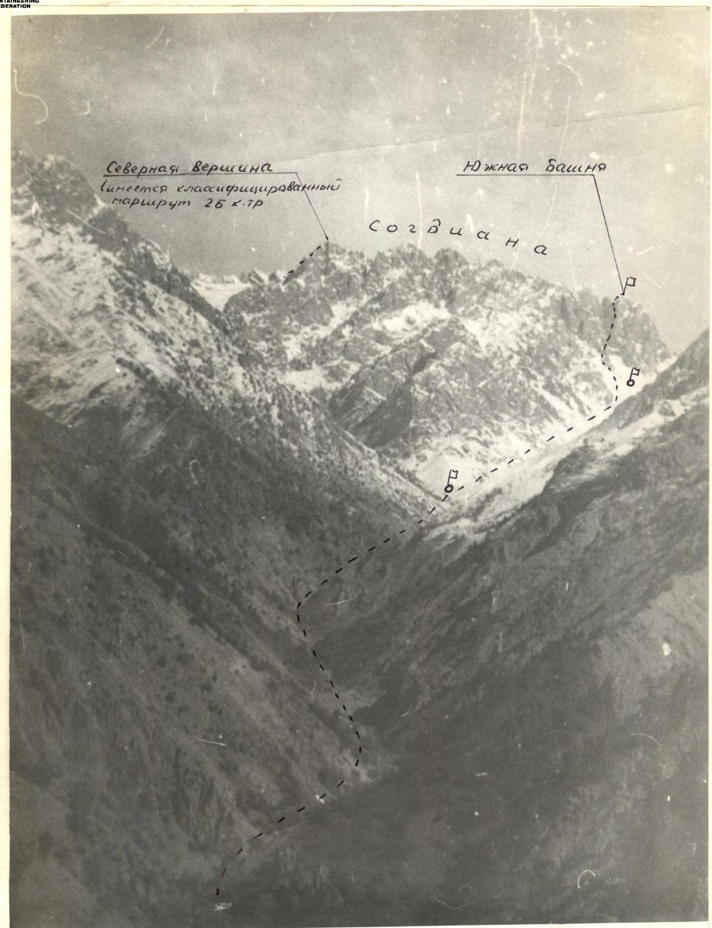 General view of Sogdiana peak from the west (photo taken in October).
Brief description of the approach to the route
From the village of Gushary, drive 1 km up the road towards the Varzob recreation center. At the bridge leading to the recreation area on the opposite bank of the Varzob River, turn right and ascend a steep trail to the ridge (400 m elevation gain) separating the Varzob River valley and Daraykulak. Follow the trail along the ridge for 500 m, then descend along a lateral spur to the Daraykulak stream (2.5 hours).
An alternative approach is possible. From the village of Gushary, immediately ascend the Daraykulak stream via a trail on the right side (upstream) to the beginning of a canyon with sheer walls — 1.5 hours. At this point, the stream makes an arcuate turn. Here it is necessary to:
- Organize a crossing
- Bypass the canyon on the opposite bank from above
- Descend back to the stream
Continue upstream along the stream on the left side (upstream) to a characteristic fork (2.5 hours). At this point, the Daraykulak stream turns left towards the Okno pass. Move straight up another stream originating from the cirque of peaks:
- Sogdiana
- Alan-Dervish
- and others.
Move along the left side (upstream) towards the couloir to the left of Sogdiana's South Tower, clearly visible during the approach. From the fork to the base of the couloir — 2.5 hours.
Table
| Date | Designations | Average steepness in degrees | Length in meters | Difficulty | Condition | Relief characteristics | Weather conditions | Pitons: Rock | Pitons: Ice | Pitons: Bolted |
|---|---|---|---|---|---|---|---|---|---|---|
| 13.09.1980 g. | R0–R1 | 30° | 50 | 2 | Dry rocks | Wall | Good | — | — | — |
| -" | R1–R2 | 60° | 120 | 3 | Dry, smooth rocks | Groove | Good | 6 | — | — |
| -" | R2–R3 | 50° | 30 | 3 | Dry rocks | Chimney | Good | 2 | — | — |
| -" | R3–R4 | 70° | 50 | 4,3 | Dry rocks | Inner corner, crack | Good | 4 | — | — |
Brief explanation of the table
The route begins in a wide couloir descending to the left of Sogdiana's South Tower. At the entrance to the couloir, bypass a rock sentinel on the left and continue up the couloir for 300 m to its bifurcation. In the first half of summer, the couloir is filled with snow. Belay! The route then proceeds up the right (upstream) branch of the couloir, transitioning into a large groove that leads to a saddle on the main ridge of the peak. The groove is clearly visible from below throughout its entire length.
Section R0–R1. Ascend 50 m of easy rock to a large inclined ledge.
Section R1–R2. From the ledge, ascend 120 m of moderately difficult rock, staying on the left side of the groove. Rocks are heavily worn. "Loose rocks"! Piton belay.
Section R2–R3. Ascend 30 m via a chimney to a saddle on the main ridge. Rocks are moderately difficult. Descend from the saddle down easy rocks to the opposite side of the ridge. 20 m
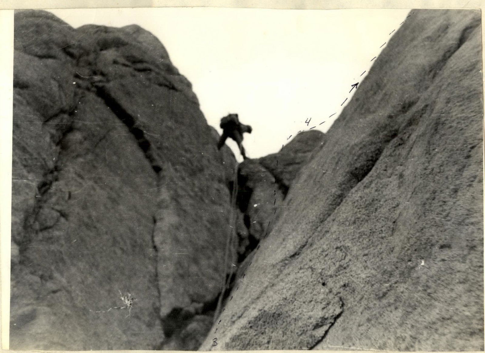
Section R3–R4. Ascend 20 m up an inner corner (difficult climbing) to a small ledge. From the ledge, ascend 10 m up a sloping crack to a shelf. Then overcome a 3-meter sheer wall and ascend 50 m of easy rock to the summit. Descent is via the ascent route. Almost the entire descent requires rappelling with rope retrieval.
Possible bivouac locations:
- at the fork of two streams;
- in the cirque below Sogdiana's South Tower.

Right branch of the couloir. Sections R0–R1–R2–R3. www.alpfederation.ru↗
Section R3–R4. Inner corner. (Photo taken during descent). www.alpfederation.ru↗