 ASCENT DOCUMENT
- Climbing type: rock climbing
- Climbing area (according to KTMGV): Gissar Range
- Peak, its height, and ascent route: Sangi-Navishta, 3980 m via the eastern wall.
- Estimated difficulty category: 4A
- Route characteristics: elevation gain: 600 m average steepness: 55° section lengths: 180 m, 280 m, 370 m, 480 m, 540 m, 6... m.
- Pitons hammered: for belaying: rock pitons 58 for creating artificial anchors (ИТО): ice pitons ..., bolt pitons ...
- Number of climbing hours: 9
- Number of bivouacs, their characteristics: none
- Full name of the leader and participants, their sports qualification: Aizenberg Viktor Aronovich, 1st sports category Lorents Evgeny Olegovich, 2nd sports category
- Team coach: Rizaev Leonid, Master of Sports, instructor
- Date of departure and return: June 25, 1978
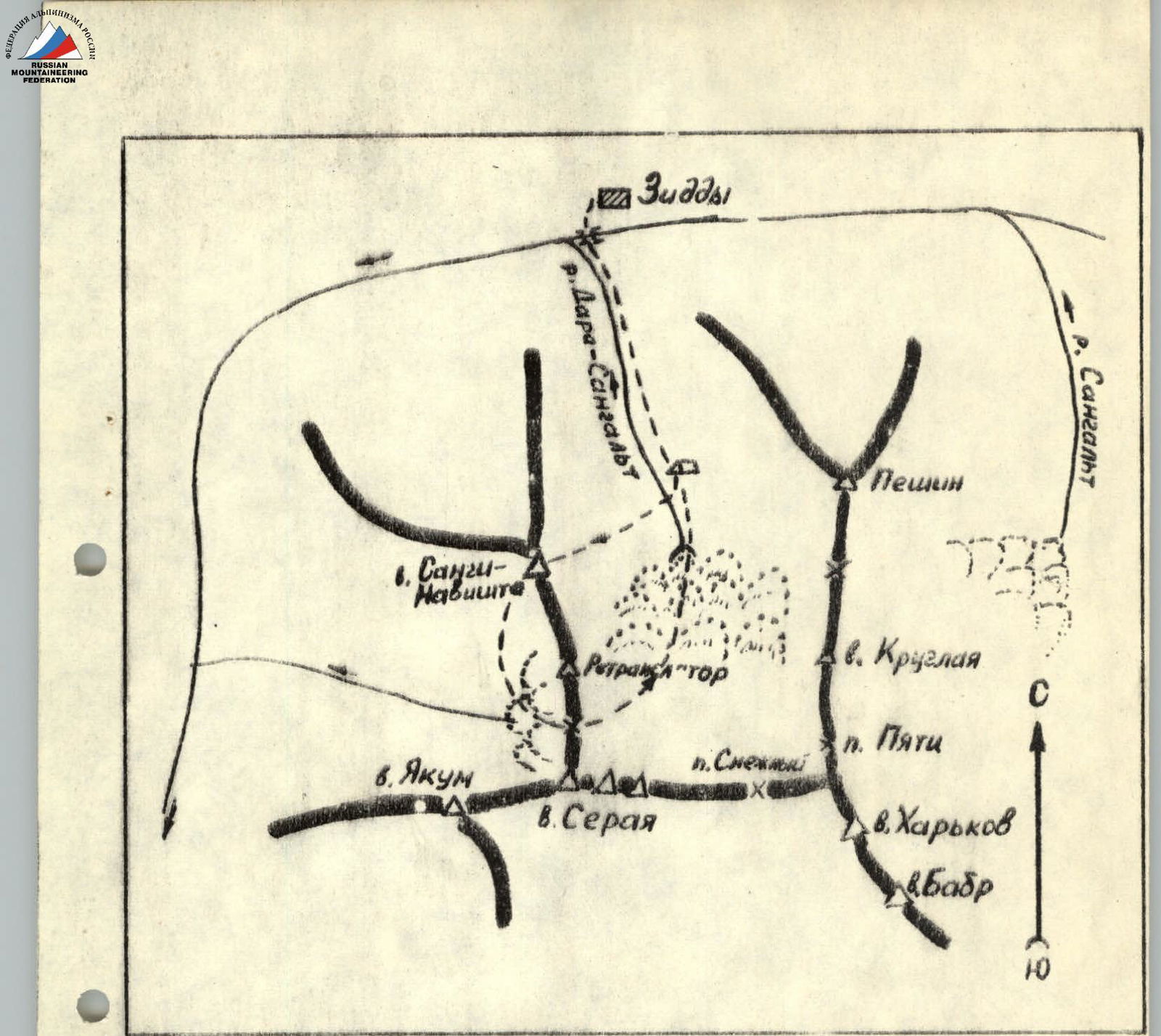 Map of the ascent area (Sangalt)
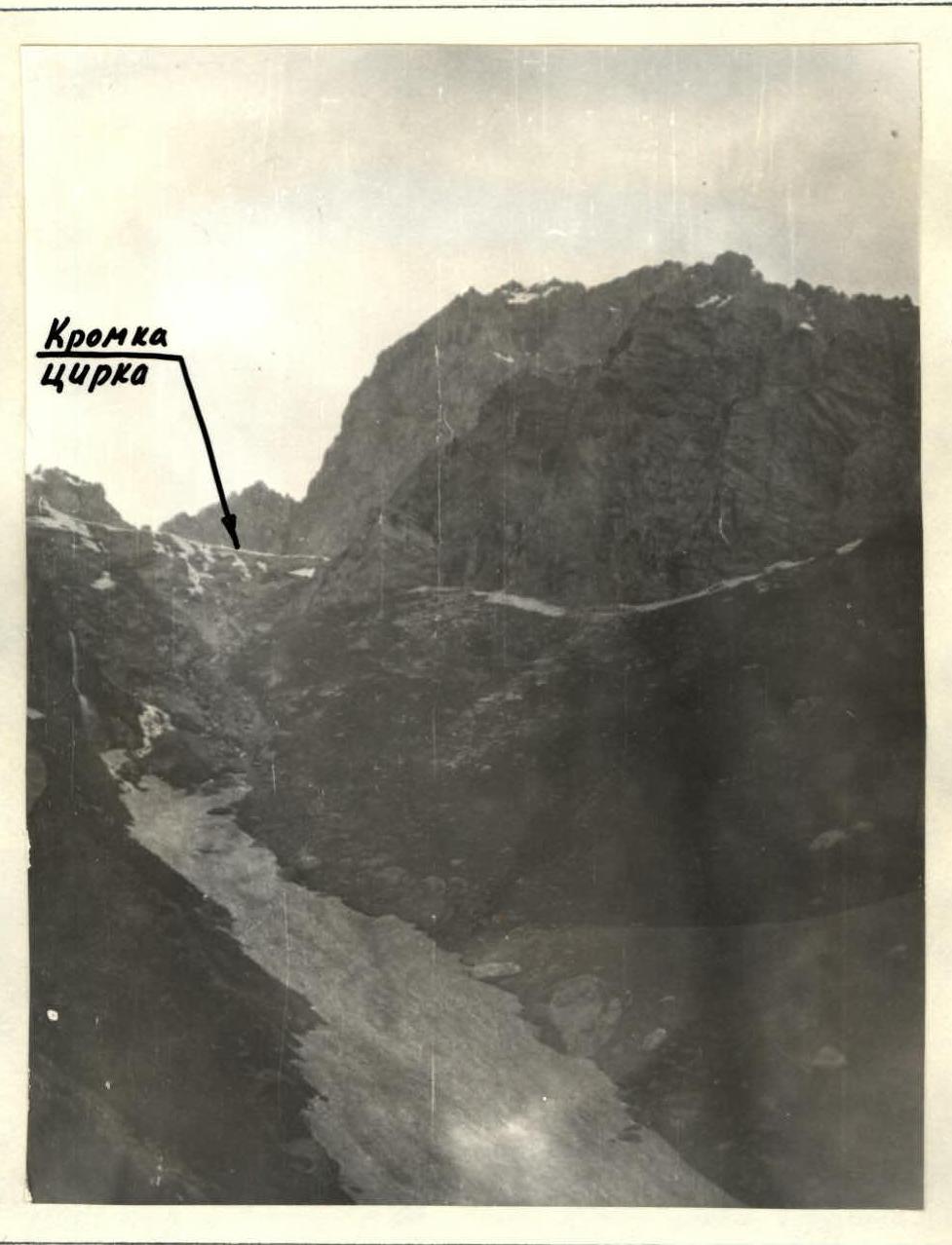
The Sangi-Navishta peak is located in the northwestern spur of the "horseshoe" of the Darai-Sangal't River.
The approach to the bivouac from the Ziddy village to the canyon takes 1 hour 30 minutes.
From the bivouac, the massif of the peak and the upper part of the route are clearly visible.
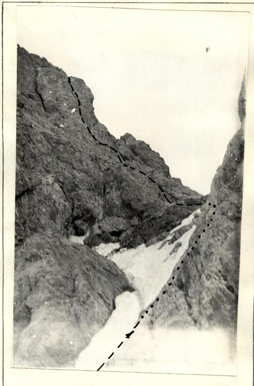
From the bivouac, ascend in a western direction along the scree slopes to the couloir located to the right of the characteristic monolithic wall, which is the left (orographic) side of the canyon. Early in the spring, the couloir is traversed along the bottom. More often, the snowy bed of the couloir is broken by a waterfall, which should be bypassed on the left along the ledges. The ascent to the ledges should begin 150 m below the break. When passing the ledges, belaying is required (2 ropes).
Further - exit to the grassy slopes (possibly snow), along which ascend to the snowy cirque with the peak massif.
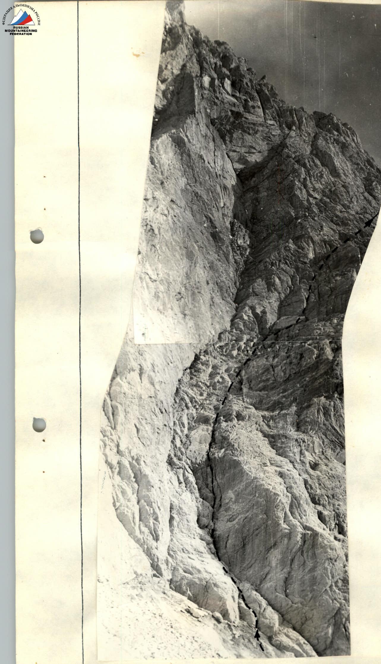
A characteristic landmark at the start of the route is the exit of white rocks in the form of a strip located in the lower third of the wall from left to right. Ascend to the strip along the snowy couloir.
The general direction of the route: starting from the strip, from left to right upwards to the black gully that cuts through the wall, and then, crossing the gully, along its right (in the direction of travel) side.
The approach takes 2 hours.
Brief explanation for Table No. 2
R0–R1. Along the inclined white-colored gully - 2 ropes. The first 40 m of the rock are of medium difficulty, covered with limestone dust, which requires careful belaying. Further along the ledges - exit under the dark, inclined slab. On the left, a wall of rusty color with streaks overhangs.
R1–R2. Up the inclined slab with an exit to a small scree ledge. 1st control point.
R2–R3. From the control point - traverse to the right to the gully. Up the gully and to the right to a black, inclined slab of triangular shape. On the left, rusty, torn rocks overlap the slab.
R3–R4. Along the slab 20 m along the boundary of the rocks (there are sections of difficult rock) and further to the right upwards along a small couloir to the shoulder of the counterfort.
R4–R5. From the shoulder upwards to the right along destroyed slabs and further in traverse - exit to the depression formed by the black gully. The section is prone to rockfall.
R5–R6. Cross the depression and along the snowy slope, exit to the shoulder of the counterfort, which is the right (in the direction of travel) side of the black gully. On the shoulder - 2nd control point.
R6–R7. Ascend the counterfort along steep, difficult and medium rocks. Further - a section of destroyed rocks (prone to rockfall): bypassing a large rock and exit to a characteristic breakaway from the wall to a small ledge. The entire section - 4 ropes. Directly above the ledge - an overhanging chimney, behind the breakaway begin rockfalls.
R7–R8 (KEY). From the ledge, traverse left upwards along the wall in the direction of the bend, behind which is a shallow gully-chimney. Very tense climbing: rocks are complex, smoothed, few cracks for pitons. Section 20 m. Behind the bend - transition to the chimney (difficult), along which (20 m) - exit to a scree ledge. On the ledge - 3rd control point.
It is necessary to check the variant of traversing "with a pendulum", for which it is necessary to organize a reliable piton belay as high as possible to the left above the ledge.
R8–R9. From the control point along the crevice formed by the "spotted" wall and the inclined slab, 40 m of medium and easy climbing.
R9–R10. A section of easy rocks leads under the chimney. On the left below remains an extensive snowy depression, clearly visible from below from the cirque, turning above and below into black gullies.
R10–R11. Chimney with smoothed sides. Rocks are medium, 20 m. Exit under easy rocks.
R11–R12. Along easy rocks 40 m with an exit to a snowy ascent, along which ascend to the summit ridge. Along the ridge to the right 100 m to the summit.
Descent from the summit along the ridge, bypassing the "gendarmeries" on the right, to the southwest. Descend to the saddle between the main massif of Sangi-Navishta and the next peak. Further down along the snowy slopes with a traverse - with the minimum possible loss of height, bypassing the rocky rockfalls - exit to the "Prostorny" pass.
Descent by rappel is possible from the above-mentioned saddle to the east along the "ram's foreheads".
Additional information about the route
The route is not recommended for a group undertaking their first 4A ascent. This is due to the tense passage of the key section without the possibility of reliable piton belaying.
| Date | Designation | Average steepness (°) | Length (m) | Relief characteristics | Difficulty | Condition | Weather conditions | Pitons | ||
|---|---|---|---|---|---|---|---|---|---|---|
| Rock | Ice | Bolt | ||||||||
| 25.06.1978 | R0–R1 | 40° | 100 m | Gully, ledges | 3, 2 | Covered with limestone dust | good | 3 | – | – |
| –//– | R1–R2 | 50° | 40 m | Slab | 3 | Monolith | –//– | 4 | – | – |
| –//– | R2–R3 | 55° | 40 m | Wall | 3 | Monolith | –//– | 5 | – | – |
| –//– | R3–R4 | 45° | 50 m | Slab, couloir | 4 | Monolith | –//– | 6 | – | – |
| –//– | R4–R5 | 40° | 60 m | Slabs, wall | 3 | Destroyed rocks | –//– | 7 | – | – |
| –//– | R5–R6 | 35° | 100 m | Depression, snowy slope | 2, 3 | Prone to rockfall | –//– | Protrusions | – | – |
| –//– | R6–R7 | 25° | 160 m | Wall | 4 | Monolithic and destroyed rocks | –//– | 16 | – | – |
| –//– | R7–R8 | 80° | 40 m | Wall, chimney | 5 | Monolith | –//– | 8 | – | – |
| –//– | R8–R9 | 70° | 40 m | Crevice | 4 | Monolith | –//– | 5 | – | – |
| –//– | R9–R10 | 45° | 40 m | Rocky slope | 2, 3 | Destroyed rocks | –//– | Protrusions | – | – |
| –//– | R10–R11 | 70° | 40 m | Chimney, wall | 4, 3 | Monolith | –//– | 4 | – | – |
| –//– | R11–R12 | 45° | 140 m | Rocky slope, snowy ascent | 2, 1 | Destroyed rocks | –//– | Protrusions | – | – |
 General view of the peak
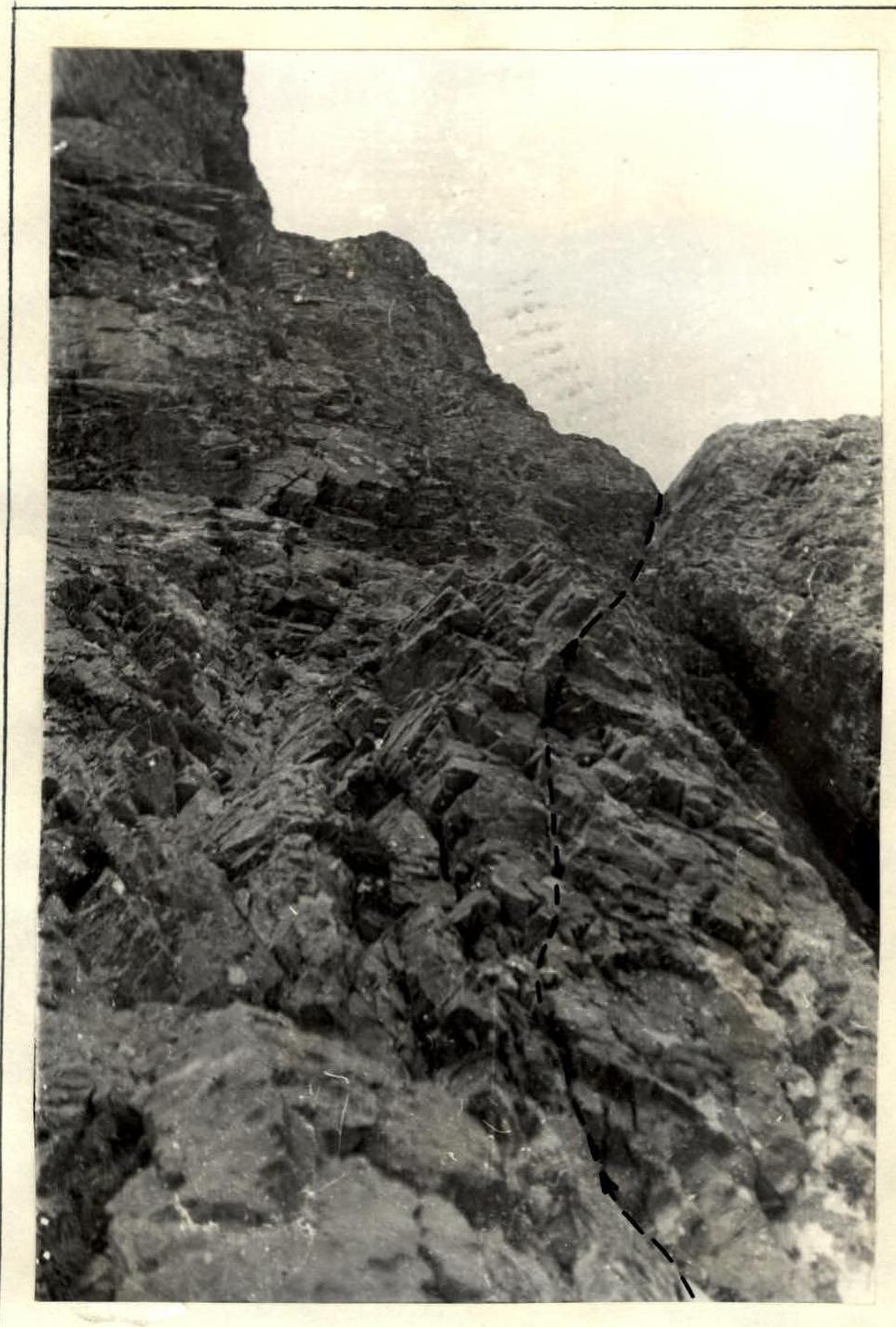
 R0–R1
R0–R1
 Beginning of R3–R4
 Exit from the depression and beginning of R6–R7
 Second "rope" R6–R7