ASCENT DOCUMENT
- Climbing category: rock climbing.
- Climbing area: Margib mountain junction.
- Peak, its height, ascent route: p. Regi-Kolon, 4060 m, South-Eastern ridge.
- Proposed difficulty category: 4A cat. diff.
- Route characteristics: height difference — 400 m, length of sections R5–R6 cat. diff. — 35 m, average steepness — 67°.
- 22 rock anchors were hammered in for belaying.
- Number of climbing hours: 8 hours.
- Number of overnight stays and their characteristics: no overnight stays.
- Surname, name, patronymic of the leader and participants and their qualifications:
Gorodilov B.Ya., 1st sports category, instructor-methodologist 2nd cat. diff., leader; Rubinsky N.D., CMS, instructor-methodologist 1st cat. diff.; Bashko V.A., 1st sports category, instructor-methodologist 2nd cat. diff.
-
Team coach: Martynov I.A.
-
Date of departure on the route and return: August 13, 1980.

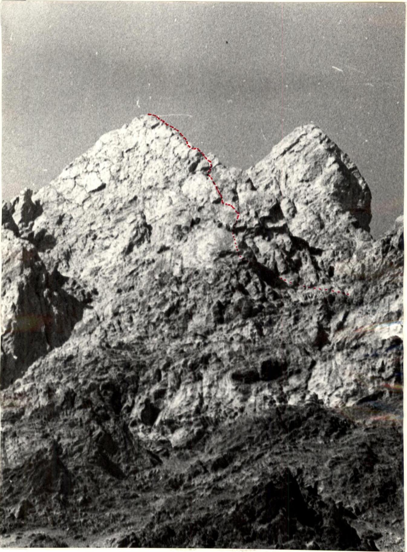
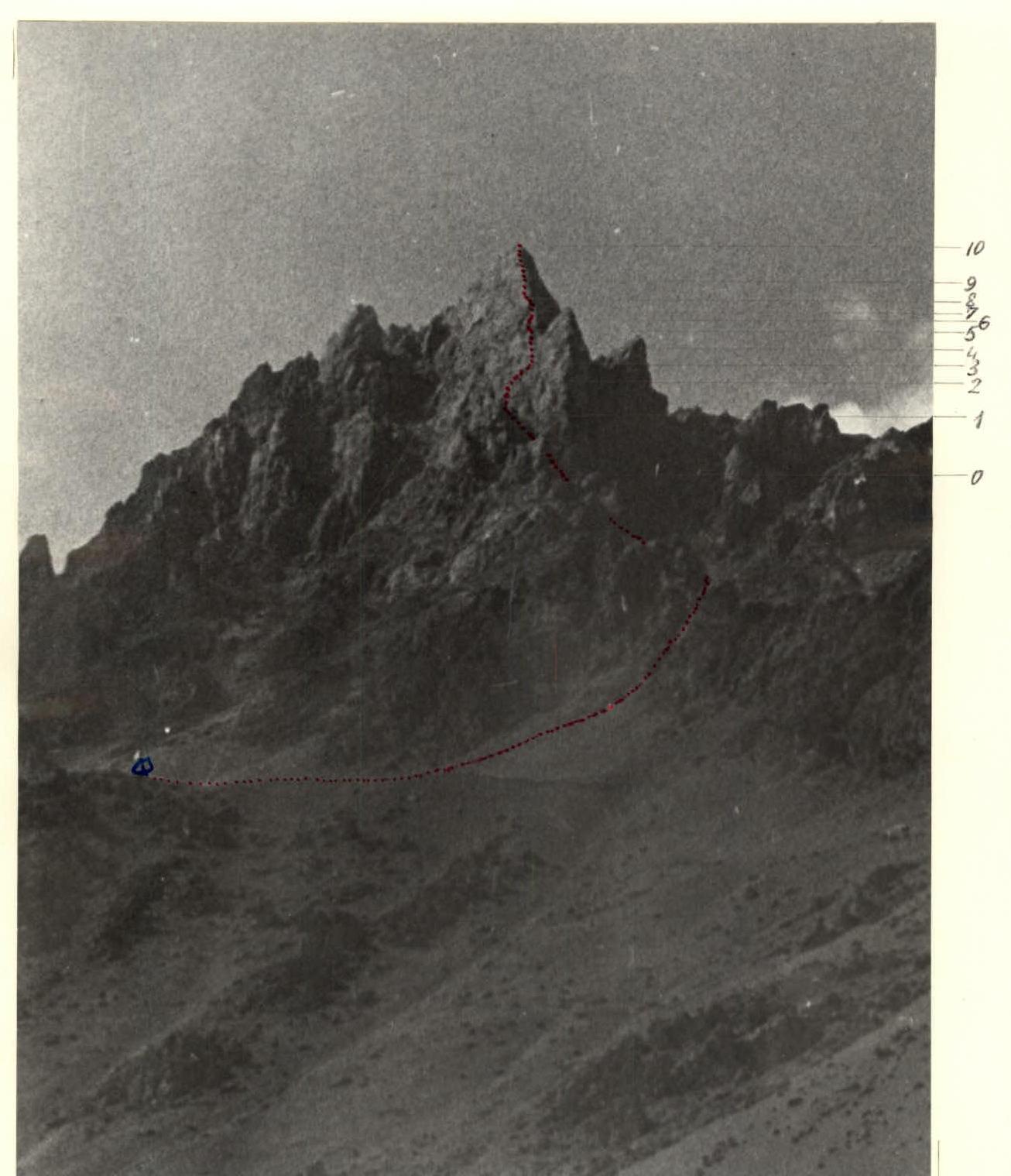 p. Regi-Kolon (photo from the village of Upper Margib)
TABLE I.

| Date | Designation | Average steepness (degrees) | Length (m) | Terrain characteristics | Difficulty | Condition, weather | Rock anchors | Ice anchors | Bolt anchors |
|---|---|---|---|---|---|---|---|---|---|
| R0–R1 | 50 | 60 | couloir | 3 | loose rocks, sun | ledges | — | — | |
| R1–R2 | 80 | 40 | wall | 4 | — | 4, ledges | — | — | |
| R2–R3 | 60 | 30 | internal angle | 3 | monolith | 2 | — | — | |
| R3–R4 | 75 | 40 | wall | 4 | monolith | 3, ledges | — | — | |
| R4–R5 | 70 | 40 | crack, chimney | 4 | loose rocks | 2, ledges | — | — | |
| August 13, 1980 | R5–R6 | 90 | 20 | wall | 5 | monolith | 3 | — | — |
| R6–R7 | 75 | 15 | crack-internal | 5 | monolith | 3 | — | — | |
| R7–R8 | 70 | 40 | ridge | 4 | monolith | 2, ledges | — | — | |
| R8–R9 | 75 | 35 | wall | 4 | monolith | 3 | — | — | |
| R9–R10 | 60 | 120 | ridge | 3 | monolith | ledges | — | — |
Brief explanation for Table I
From the base of the South-Eastern ridge, leftward along the rocky couloir ending in an overhanging rock, exit to the saddle between the southern wall of the summit and the descending rocky ridge (R0–R1). From the saddle, along the steep broken rocks of the southern wall, leftward and upward (R1–R2). Then along the internal angle (R2–R3) — exit under the wall with a large cornice (R3–R4). Along the wall straight up and under the cornice — traverse left and up — approach to the crack turning into a steep chimney with pitons (R4–R5). From the chimney — exit to a scree shelf on the ridge. Along the shelf leftward and then up along the vertical, overhanging in the lower part, wall with a crack (R5–R6), then leftward along the crack — exit to the ridge (R6–R7). Further along the ridge (R7–R8) and left of the ridge along the wall (R8–R9) — again exit to the ridge and along the ridge to the summit (R9–R10).
Descent from the summit along the Eastern ridge, bypassing a large gendarme on the left, and along the couloir — descent to the starting point of the route.
The Regi-Kolon peak is located in the Margib mountain junction, situated between the Zeravshan and Gissar ridges.
The ascent was made by coaches of the Kharkov city sports committee expedition as part of the expedition's work plan.
The route climbed is purely rock climbing and technically quite challenging. The participants have experience working with young climbers in the Baksan and Dombay regions, and compared to the rock climbing routes in these regions, the technical difficulty of the route corresponds to the 4th-6th category of difficulty, but since the route is purely rock climbing and quite short, the group proposes to classify the route as 4A cat. diff.
During the passage of the route, the group used:
- ordinary rock anchors;
- chocks.
Below are photographs of sections of the route taken during the ascent:

It should also be noted that in August, when the ascent was made, there is no water at the bivouac under the route.
Start of the route. Base of the South-Eastern ridge. (Section R0–R1)