Moscow Regional Council
of the Voluntary Sports Society
"TRUD"
Description
Ascent to the summit of Odessa via the Odessa pass Category III complexity
MOSCOW 1963
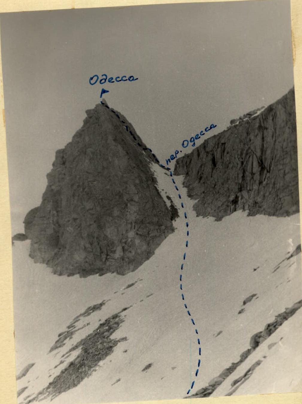
Mt. Odessa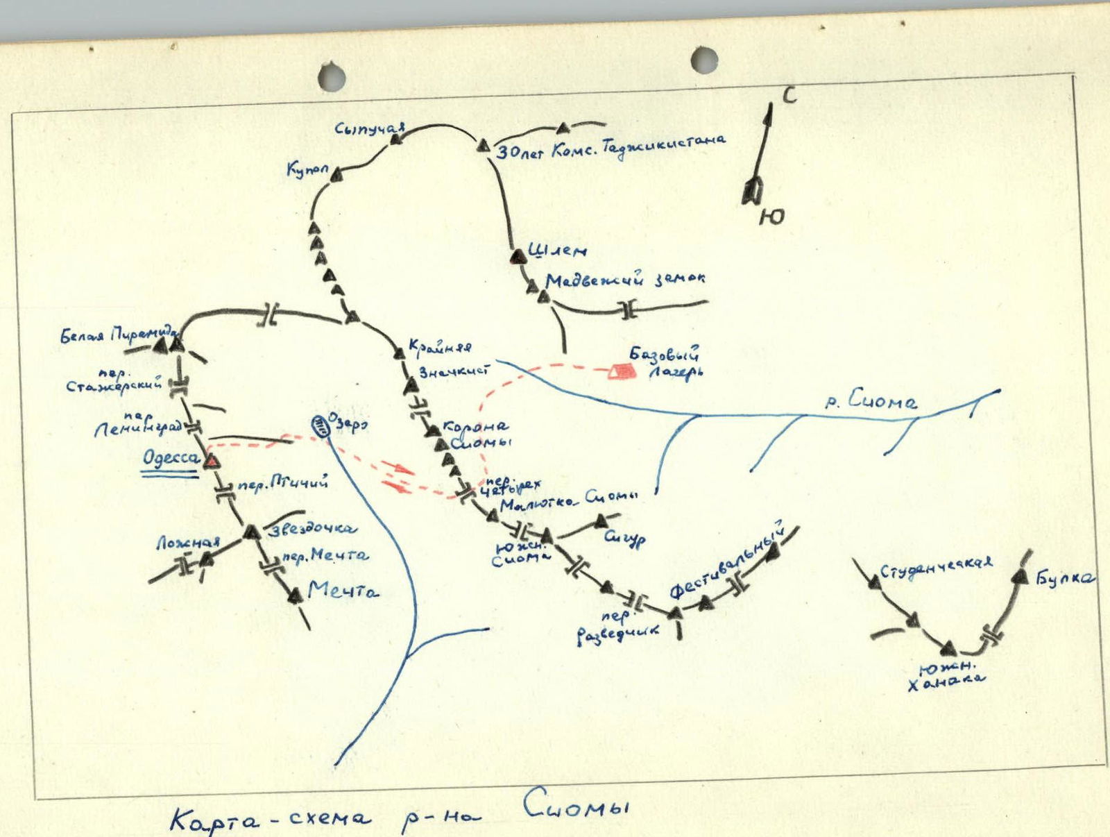
Map of the Siama region
Description of the Climbing Area
The Siama region is located in the Gissar Range, which runs southwest of the Fann Mountains. The Siama region has been fairly well explored. There are routes of the third, fourth, and even fifth category of difficulty on the peaks Korona Siamy, Shlem, Festivalnaya, Medvezhiy Zamok, and Mt. Mechta.
The Odessa peak (4250 m) is located in the middle part of the ridge, stretching from southeast to northwest, from Mt. Mechta (4700 m) to Mt. Belaya Piramida (5033 m). Almost all routes in this area are rock routes.
From the "Varzob" alpine camp to the upper reaches of the Siama River is a one-day hike with pack animals.
A base camp is organized on a flat clearing under the southern slopes of Mt. Medvezhiy Zamok.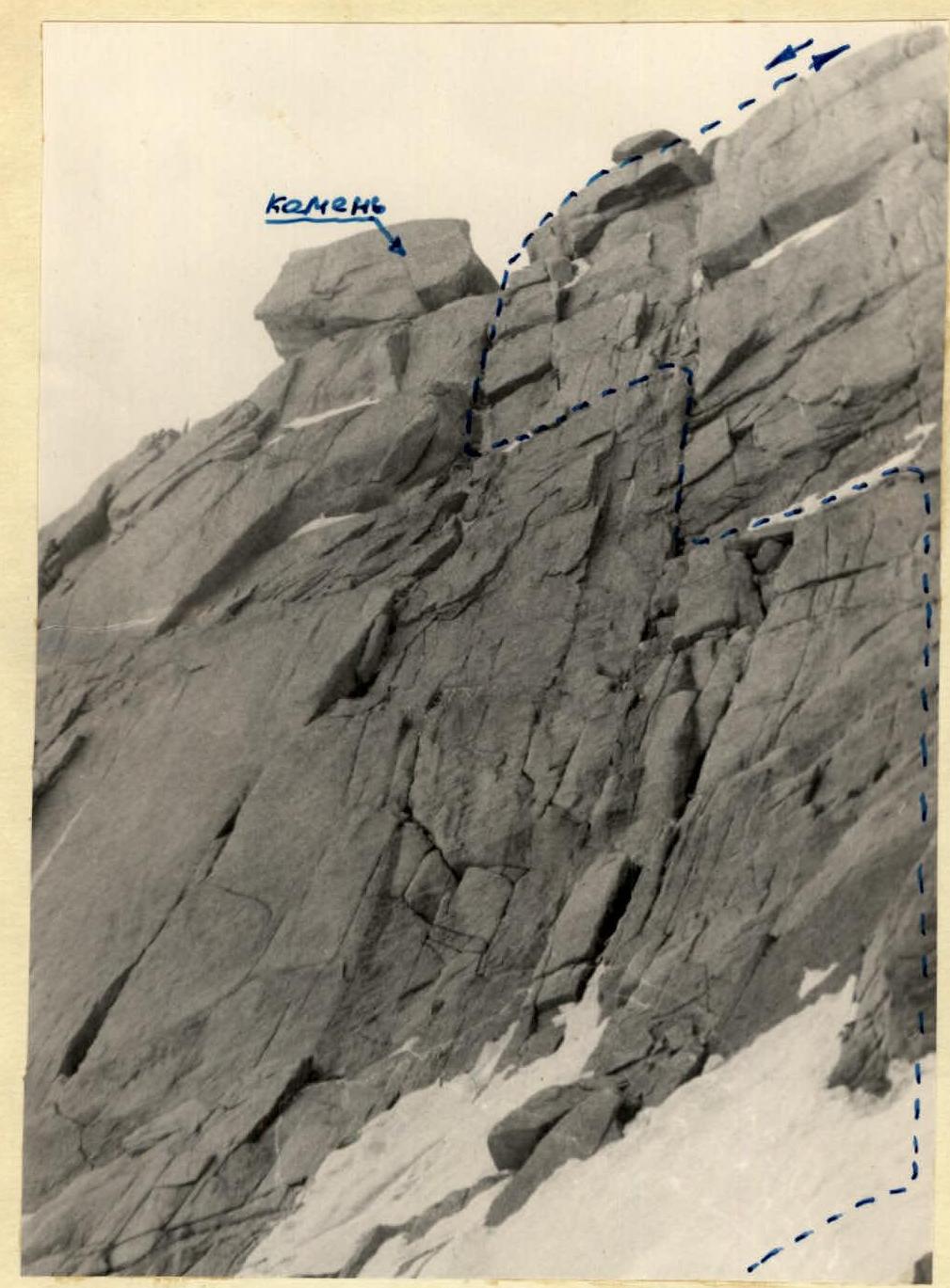 North wall of Mt. Odessa (view from the Odessa pass)
Description of the Ascent
On July 19, 1963, a group of climbers from the Moscow Regional Council of the Voluntary Sports Society "TRUD" consisting of:
team leader Andreev V. — 1st sports category, team members Barashkov V. — 1st sports category, Sadovsky V. — 1st sports category, Penchuk A. — 2nd sports category, Fedorov O. — 2nd sports category, set out from the base camp under Medvezhiy Zamok at 6:00 AM on a training ascent to Mt. Odessa. The path initially goes across scree and then across snow to the "Chetyrekh" pass (3600 m), located to the left of the Korona Siamy peak, which blocks the gorge with its jagged ridge. The ascent to the "Chetyrekh" pass is up a snowy slope with a gradient of 30-45°. The journey from the base camp to the "Chetyrekh" pass takes 2.5-3 hours. From the pass, the sharp pyramid of Mt. Odessa and the approaches to it are clearly visible. The descent from the pass goes down the snow to a lake located below on the eastern glacier of Mt. Belaya Piramida and takes 5-10 minutes. After circling the lake on the left side, we proceed straight up to a rocky ridge. Initially, the rocks are bypassed on the right across the snow, then, after reaching a snow "cushion", we cross the ridge and, traversing the rocks on the left across the snow, we head towards the Odessa pass, located to the left of Mt. Odessa. The ascent to the pass goes up a narrow and steep (up to 60° at the top) snow couloir, 150 m long. The Odessa pass (marked with a cairn) is a narrow and short (6-8 m) rocky saddle. The journey from the "Chetyrekh" pass to the Odessa pass takes 3 hours. From the pass, the path to Mt. Odessa goes straight up the wall, which has a gradient of 60-70° and is 110 m high. The wall consists of smooth monolithic slabs with good cracks for pitons. Initially, we climb one rope length up, then move left along a narrow ledge for 10 m, then climb another 25 m, followed by another traverse left along a ledge for 8 m, and finally, another rope length up a narrow vertical crack leads to a large boulder on the shoulder. This boulder is visible from the Odessa pass. The entire wall is climbed with thorough piton protection, with 8 pitons placed. From the boulder to the summit, it takes 2 minutes, and from the pass, 2-2.5 hours.
The descent from the summit follows the ascent route. From the boulder, three rappels are made directly into the couloir, which was used to ascend to the pass. We return to the base camp along the same route. The descent from Mt. Odessa and return to the base camp takes 3-3.5 hours.
Conclusions
The group believes that the amount of work and technical difficulty involved in ascending Mt. Odessa via the Odessa pass justify classifying this route as Category III, rather than Category II, as it is currently classified.