
ALPINISM FEDERATION OF LITOVSKAYA SSR
REPORT
IV team "Žalgiris" on the ascent to the north-eastern peak of Nemsha (first ascent)
650 35°, I–120 m, II–600 m, III–900 m, IV–40 m. n-g1 3 hours, Days, 10 hours.
Z. Karčiauskas, V. Bitinas, V. Virišilas, V. Marazas, R. Misiunavičius.
Vilnius — 1977, 15–17 July
I. Choosing a route for the first ascent
From July 4 to August 8, alpine training camps for climbers from Litovskaya SSR were held at the foot of the Yagnob wall in the Pamir-Alai, Gissar ridge, under the guidance of the Committee for Physical Culture and Sports under the Council of Ministers of Lit. SSR. The routes on the Yagnob wall to the Zamin-Karor peaks are classified as no less than category 4B.
Therefore, easier routes are required for training ascents. Mainly, routes of 2B and 3B categories on the Vladivostok and Kuysurk peaks, located not far from the base camp, are used for this purpose.
The routes of the 2nd category on the Zamin-Karor peak from the south and on the Khose-Lot peak are characterized by long approaches and are rarely used for training ascents. Thus, one of the goals when choosing a route for the first ascent was its accessibility for training climbs. Another goal was the necessity of a first ascent for climbers fulfilling the requirements of the Candidate for Master of Sports according to the new regulations.
With these tasks in mind, the north peak of Nemsha was chosen, which is directly visible from the base camp at the foot of the Yagnob wall. The name of the peak was determined through conversations with local residents of the Morgheba village. The approximate difficulty of the first ascent route was assessed through observation with a telescope by the team along with the training staff. It was decided to choose a route to the north peak of Nemsha via the south-eastern couloirs, initially assessing this route as category 3B.
Verbal confirmation that the chosen route had not been previously climbed was obtained from the head of the control and rescue service of the "Varzob" alpine camp, S.N. Sogrin.
 II. Map of the Yagnob wall area M 1:50 000
III. Description of the approach to the route
The approach to the route on the north peak of Nemsha from the base camp (the approach to it is described in the book by S.N. Sogrin "Pamir-Alai") at the foot of the Yagnob wall is carried out in two stages.
The first stage is a transition from the base camp to overnight stays on the slope of the Nemsha massif. Initially:
- descend to the upper village of Morgheb;
- pass through the village;
- descend along the trail on the steep ravines on the left side (orographically) of the Yaghnob river to the bridge;
- cross the bridge;
- ascend along the beaten path to the sheep fence;
- ascend along the grassy slopes to two large white stones, where there is a convenient place for overnight stays — there is water and protection from the wind.
It is worth noting a milder microclimate at the overnight stays compared to the base camp, where it is too hot and dry during the day.
The entire approach with backpacks from the base camp to the overnight stays takes 1.5–2 hours. Therefore, it is recommended to head to the overnight stays after lunch.
The second stage is the approach from the overnight stays to the route. From the overnight stays, there is a 150 m ascent to the grassy ridge of the counterfort. Then along the ridge for 2000 m to a green platform.
Descend 50 m to a firm scree, along which ascend 1200 m to the middle part of the Y-shaped snowfield, where the route begins.
The approach from the overnight stays to the route takes 2–2.5 hours. It is recommended to leave the overnight stays at 5:30–6:00 am.
IV. Table of main characteristics of the first ascent route
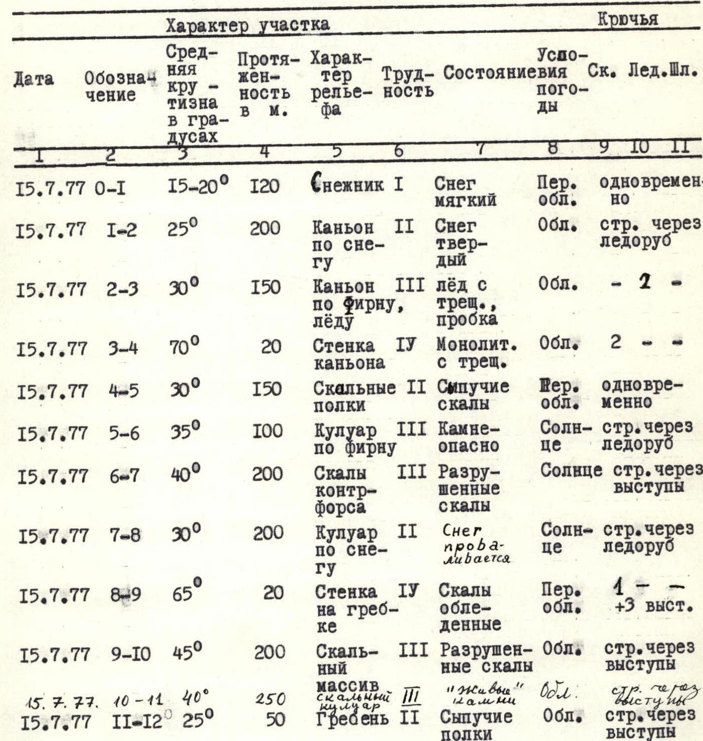
| Date | Designation | Average steepness in degrees | Length in meters | Character of relief | Difficulty | Weather conditions | Conditions | Pitons Rock | Ice | Bolts |
|---|---|---|---|---|---|---|---|---|---|---|
| 15.7.77 | R0–R1 | 15–20° | 120 | Snowfield I | Soft snow | Partly cloudy | Simultaneously | |||
| 15.7.77 | R1–R2 | 25° | 200 | Canyon II on snow | Hard snow | Cloudy | belay through ice axe | |||
| 15.7.77 | R2–R3 | 30° | 150 | Canyon III on firn, ice | Ice with cracks, plug | Cloudy | — 2 — | |||
| 15.7.77 | R3–R4 | 70° | 20 | Wall IV of canyon | Monolithic with cracks | Cloudy | 2 — | |||
| 15.7.77 | R4–R5 | 30° | 150 | Rocky II shelves | Loose rocks | Top cloudy | Simultaneously | |||
| 15.7.77 | R5–R6 | 35° | 100 | Couloir III on firn | Rockfall hazard | Sunny | belay through ice axe | |||
| 15.7.77 | R6–R7 | 40° | 200 | Rocks of counterfort | III Destroyed rocks | Sunny | belay through ledges | |||
| 15.7.77 | R7–R8 | 30° | 200 | Couloir II on snow | Snow collapses | Sunny | belay through ice axe | |||
| 15.7.77 | R8–R9 | 65° | 20 | Wall IV on ridge | Icy rocks | Partly cloudy | 1 — +3 ledges | |||
| 15.7.77 | R9–R10 | 45° | 200 | Rocky massif | III Destroyed rocks | Cloudy | belay through ledges | |||
| 15.7.77 | R10–R11 | 40° | 250 | Rocky couloir | III "Live" stones | Cloudy | belay through ledges | |||
| 15.7.77 | R11–R12 | 25° | 50 | Ridge II | Loose shelves | Cloudy | belay through ledges |
Team leader: Z. Karčiauskas Team coach: A.V. Petrov
V. Description of the route passage
At the beginning of the route, in the middle part of the Y-shaped snowfield, the climbers tie in as follows:
one rope team: V. Bitinas — Z. Karčiauskas, another rope team: V. Virišilas — V. Marazas — R. Misiunavičius.
Section R0–R1:
- point 0 — middle part of the Y-shaped snowfield;
- point 1 — entrance to the canyon.
This section is traversed simultaneously. The snow is soft — footprints are made with one touch. There are traces of stones that have flown from the rocky massif of Nemsha.
Section R1–R2 (point 2 — turn of the canyon to the left, where it narrows). When passing this section, belay through an ice axe in the snow is used, as there are crevices at the walls of the canyon. Passing through the canyon is rockfall-safe, as the slightly overhanging walls of the canyon protect from stones coming from above.
Section R2–R3 (point 3 — plug in the canyon, in the form of a stone with a diameter of 2.5 m). The route becomes steeper, snow turns into firn, and ice with cracks appears diagonally across the canyon. It is necessary to cut steps. When crossing a crevice, 2 ice pitons are hammered.
At the stone forming the plug, there is a crevice that hinders passage through the plug. A decision is made to exit to the top of the canyon.
Section R3–R4 (point 4 — upper part of the canyon at the plug). This section represents the wall of the canyon. The wall has cracks and ledges, with the help of which the wall is climbed. For belay, 2 rock pitons are hammered. At the top of the canyon, using ledges, a rope is fixed and a belay is organized.
Section R4–R5 (point 5 — transition from rocky shelves to a snowy couloir):
- along the upper part of the canyon, loose rocks are traversed simultaneously in the direction coinciding with the direction of the canyon, to a snowy couloir;
- into which the previously passed canyon transforms.
Section R5–R6 (point 6 — wall of the counterfort ending the snowy couloir).
The snowy couloir is traversed alternately with belay through an ice axe. The snow is hard, with firn in some places, where steps need to be cut. The couloir ends with a wall, which is decided not to climb, but to bypass with an exit to the counterfort.
Section R6–R7 (point 7 — transition from the counterfort to the snowy couloir leading to the ridge).
When bypassing the wall:
- traverse 15–20 m along the rocks of the counterfort to its ridge;
- then ascend to the upper part of the counterfort, keeping to the left side of the ridge.
- The rocks are destroyed, belay is through ledges.
Section R7–R8 (point 8 — end of the snowy couloir, rocky platform on the ridge).
The snowy couloir is traversed alternately with belay through an ice axe. The snow collapses, movement is difficult.
Section R8–R9 (point 9 — upper part of the rocky wall on the ridge). The wall on the ridge is icy, but it is difficult to bypass. During climbing, there are good holds, for belay, one rock piton is hammered. At the top of the wall, a rope is fixed to a ledge and a belay is organized.
Section R9–R10 (point 10 — beginning of the rocky couloir leading to the depression between the peaks). From the top of the wall, in a leftward direction, the lower part of the rocky massif of the Nemsha peak is traversed. The rocks are destroyed, belay is through ledges.
Section R10–R11 (point 11 — depression on the ridge between the peaks). The rocky couloir is traversed alternately with belay through ledges with great care, as there are many "live" stones.
Section R11–R12 (point 12 — north peak of Nemsha). The path to the peak along the scree shelves of the ridge is also traversed with great care. There is no cairn on the north peak of Nemsha. Since there were signs that people had previously been on the peak via an easier route from the north-western side, the claim of a first ascent was waived. A cairn was built, and a note about the first ascent of the north peak of Nemsha via the south-eastern couloirs was left.
Since the easier route to the north peak of Nemsha was assessed as too long for descent, the descent was made along the ascent route.
VI. Recommendations for the route passage
The route to the north peak of Nemsha via the south-eastern couloirs is logical, and replacing individual sections with others is impractical. The route is generally safe (in couloirs where there is a possibility of rockfall, safety must be ensured by the vigilance of the participants).
For the route, it is recommended to take:
- a main rope 30 m long — for a rope team;
- a rope 30 m — for the team;
- rock pitons: 3 pcs. — horizontal; 3 pcs. — vertical; ice pitons — 3 pcs.;
- ice axes — for each participant.
Crampons are not recommended. It should be noted that the character of the ascent differs from the routes on the Yagnob wall due to its combined nature. When traversing snowy sections, more waterproof footwear is required than on rocky routes.
It should also be noted that from the overnight stays near the Nemsha peak, several more first ascents can be made, ranging from the 3rd to the 5th category of difficulty.
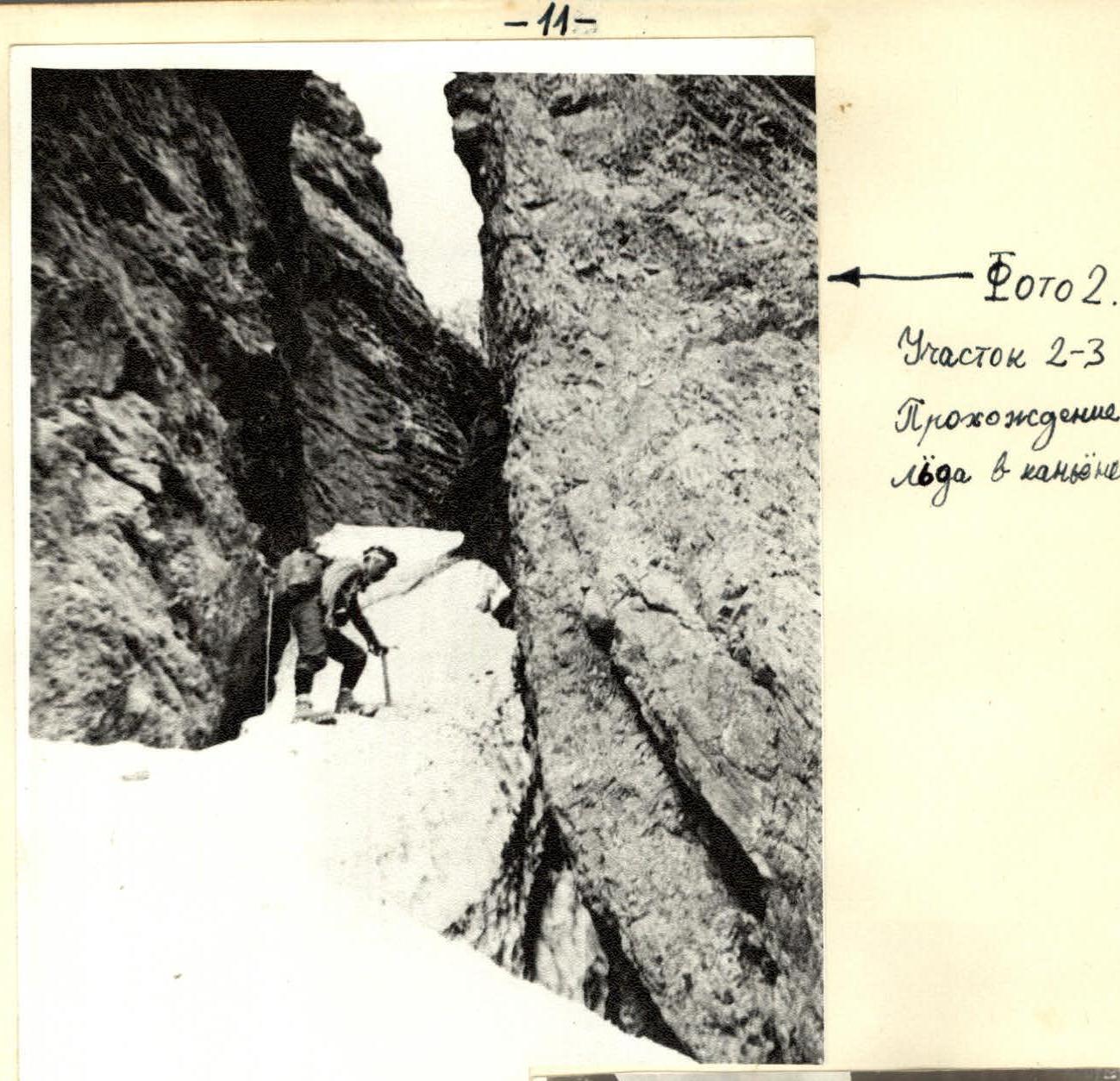 Photo 2. Section R2–R3. Passage of ice in the canyon.
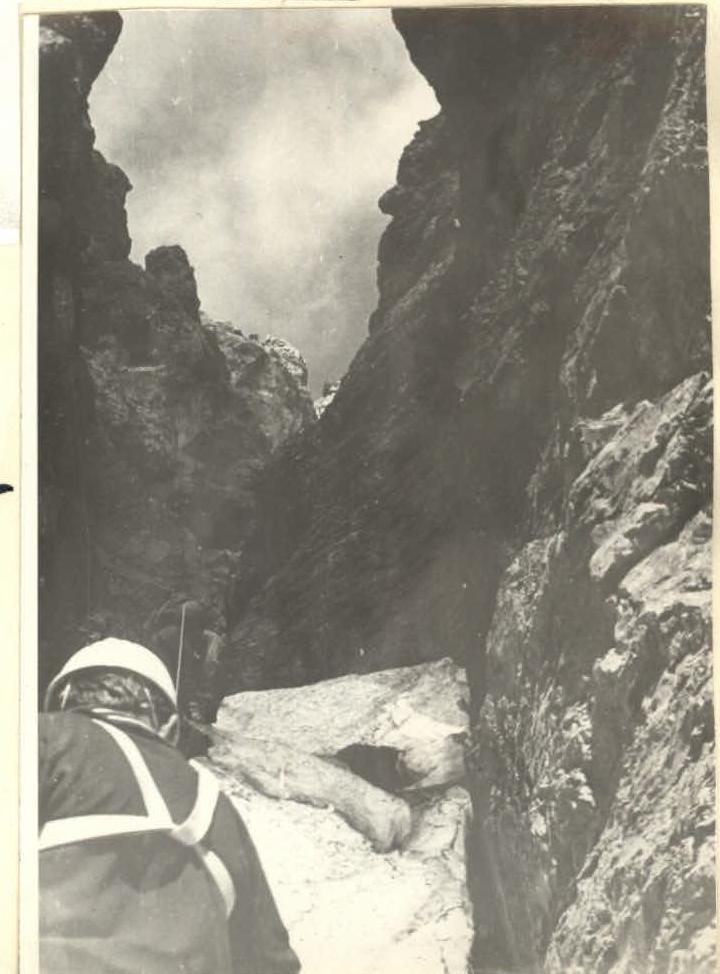 Photo 3. Section R2–R3. Passage of crevices in the canyon.
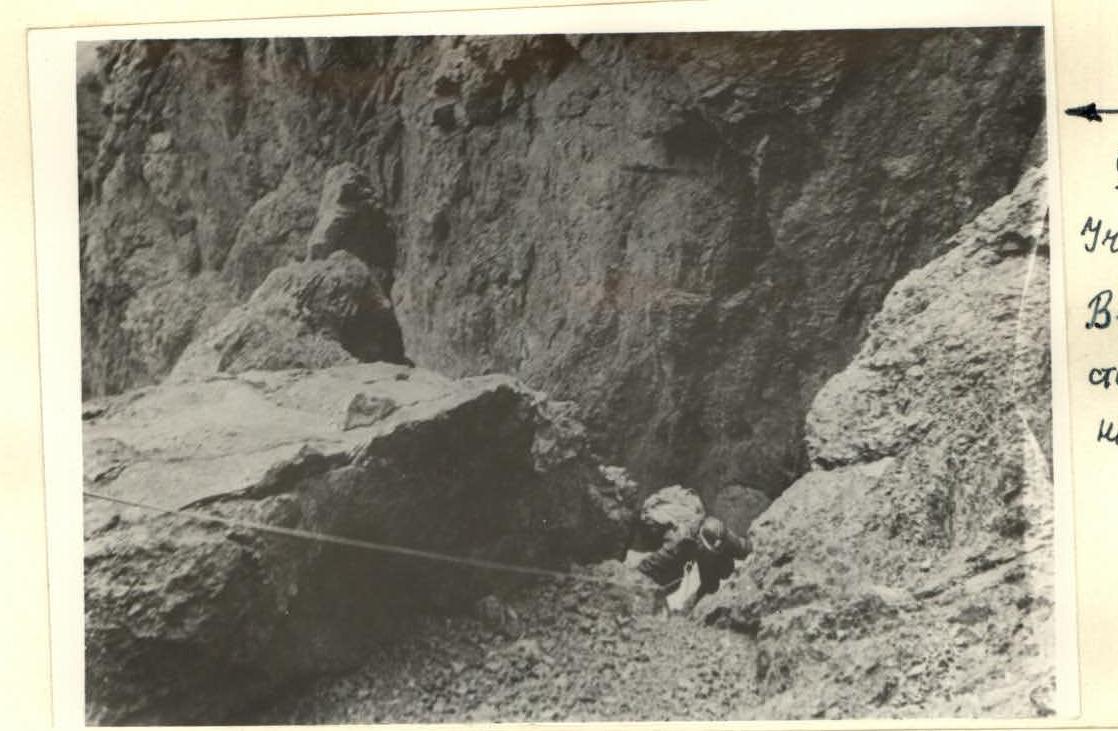 Photo 4. Section R3–R4. Exit to the wall of the canyon.
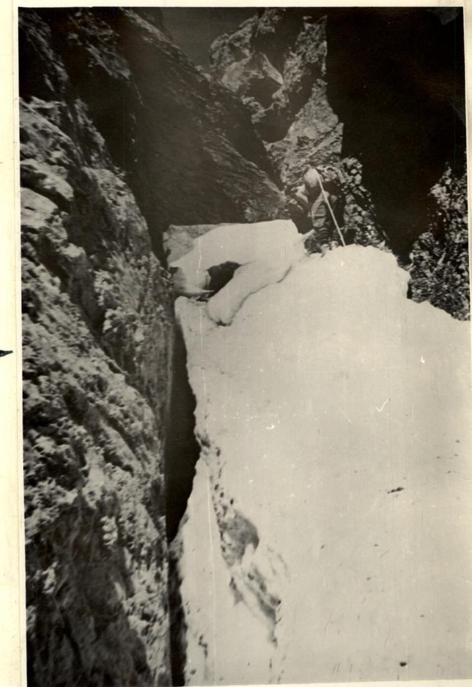 Photo 5. View from the lower part of section R7–R8.
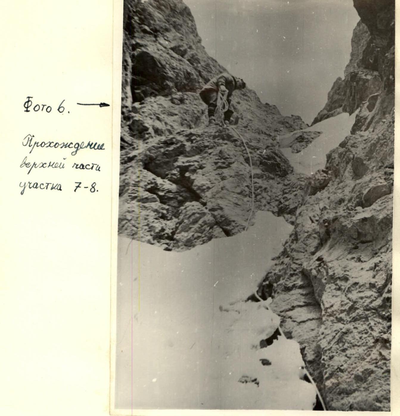 Photo 6. Passage of the upper part of section R7–R8.
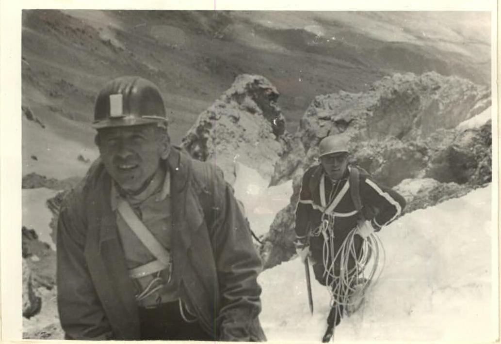 Photo 8. Rocky massif of the summit part of Nemsha.
 Photo 7. On the upper part of section R7–R8.