Ascent to Peak "Medikov"
3A — complexity category via the northern ridge
Peak "Medikov" is located in the Ivan-Kaldy ridge in the Sanghi-Navishta area. Its height is 3650 m. It has three peaks; the ascent to the central, highest one via the northern ridge is categorized as 3A complexity.
The approach to the peak is along the Gusharinka River. After driving about 1.5 km past Gushari, near two walnut trees standing alone on the left side of the road (in the direction of travel), the ascent to the pass leading to this area begins. The ascent along the trail takes about 1 hour, followed by a descent into the river valley. On the left side (in the direction of travel) of the river, after 3-4 hours of walking, it is convenient to set up an overnight stay. Firewood is available. From the overnight stay, continuing upstream along the river, after 30-40 minutes, we approach the fork of the gorges; the left one leads to the Sanghi-Navishta area towards the peaks of this area. By following this gorge, we emerge onto a wide plateau-glacier. Even from the approaches, before the last significant ascent, Peak "Medikov" is visible on the left (in the direction of travel) resembling a trident. On the plateau: to the right is the Dvukh Pass, straight ahead is the Okno Pass, and to the left is the Yuzhny Pass, which we reach by going along the peak. On Peak Yuzhny (3320 m), there is a note.
The total time for the approach from the road is 7 hours.
NOTE: The exit to Peak Yuzhny is possible directly from the pass without descending into the Gusharinka River valley, via the ridge. This path is shorter but more challenging.
R1
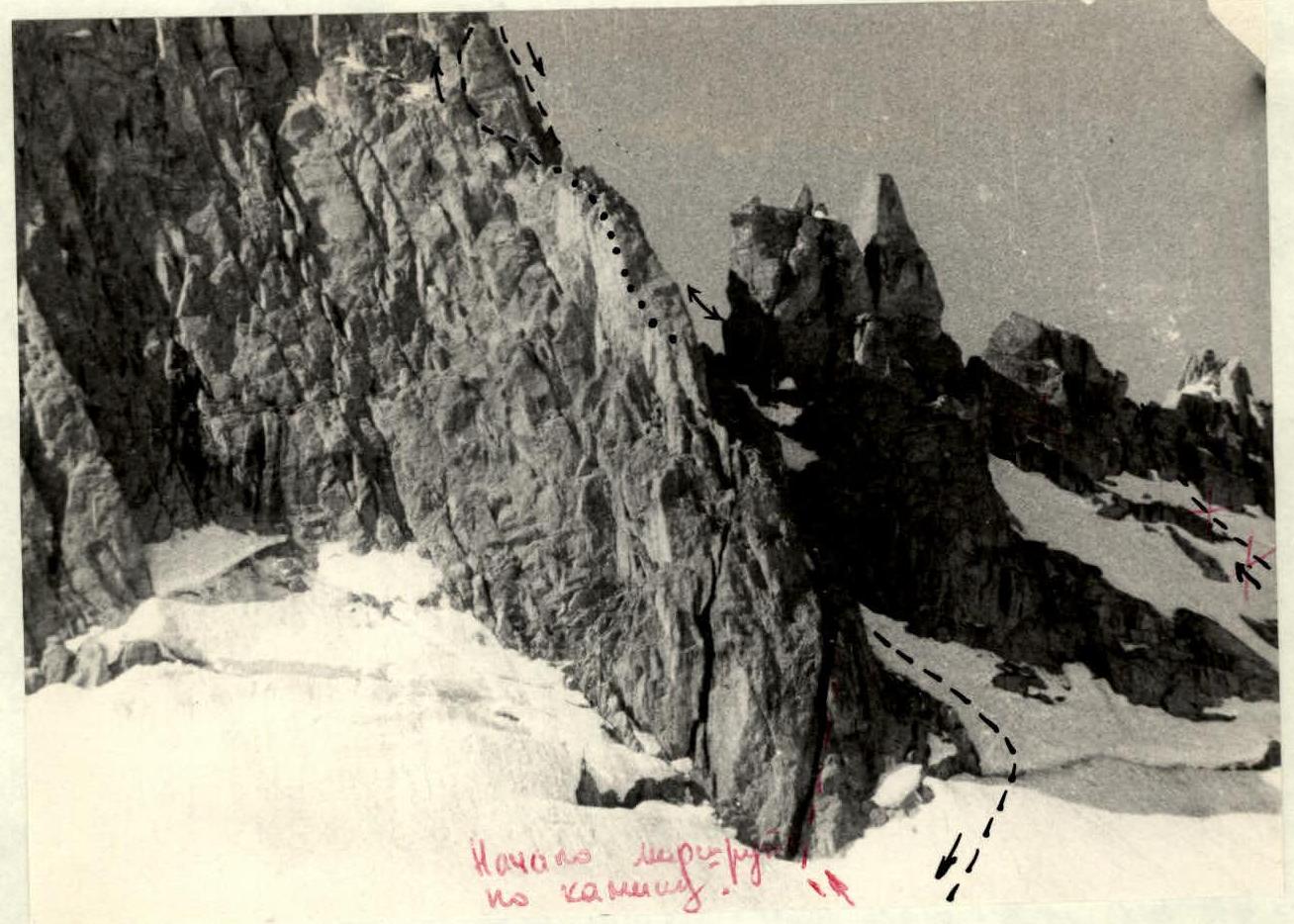
From Yuzhny Pass, we move back along the approach path and, bypassing the wall that the ridge drops to the pass (about 160 m) along the bergschrund, cross the bergschrund via the first snow bridge and begin the ascent to the ridge, moving towards the stepped rocks to the left of the extreme right gendarme-ridge. Snow (possibly ice in autumn) with a slope of about 35° and a length of about 50 m leads under the rocks.
R2
The rocks are of medium difficulty, stepped, with step heights of 2-3 m, and a large number of "live" stones. Movement is alternating, with protection on ledges. The length of this section is about 50 m, exiting onto the ridge under the extreme right gendarme-ridge (landmark).
NOTE: It is possible to ascend to other parts of the ridge, to the left of the described section, approximately not easier.
R3
Along snow with a slope of 30° (60 m), 70° – (5–6 m) down along the rocky ridge, then up along snow and easy rocks (approximately 90 m) at 30°, we exit onto a col in the ridge clearly visible from below during the approach. Movement involves alternating protection on rock ledges and simultaneous movement.
R4
From the col, along easy rocks with a slope of about 30–60°, approximately 20 m, we exit onto the shoulder of the ridge, from where the path upwards is visible.
NOTE: It is possible to ascend to the peak via two very narrow snow-rock couloirs with a slope of about 50–60°. Due to their high rockfall danger, both ascent and descent through them are considered hazardous and prohibited.
R5
Along the ridge straight, then on the left side (in the direction of travel), bypassing a small overhang and exiting onto a balcony, we approach under a 5–6 m crack. Up the sheer crack, we move straight up and along steep stepped rocks exit onto the second shoulder of the ridge, where it is possible to:
- receive a group,
- organize protection.
Here, a cairn is built, and from here, the rappel descent begins. The length of this section is 50 m, with piton protection, and a slope of up to 80°. The rocks are solid, with good placements, of medium difficulty.
R6
Along the ridge, turning left upwards, we exit onto the pre-summit shoulder. The length of this section is 40 m, with a slope of about 50°. The rocks are easy and of medium difficulty. Protection is on ledges.
R7
Along the ridge without gaining height, we approach under the pre-summit ascent. The rocks are easy, with protection on ledges; the length of this section is 30 m.
R8
The ascent to the summit is in a helical manner: to the right (in the direction of travel) along ledges. The rocks are of medium difficulty, with a slope of up to 70°, and protection is on ledges. The length of this section is 30 m.
Summit
A rectangular stone about 2 m high. A cairn is built below it, on the left shoulder, under stones. Notes are not left on the other two peaks.
Descent is along the ascent path to the col, climbing with alternating protection to the control cairn. From there, a 50 m rappel to the left downwards, not along the ascent path, but along a 70° wall onto easy rocks leading from the col. From the col, descent onto the glacier, to the right (in the direction of travel), along which the approaches were made. First, from the col, 30 m down to the left onto a sport balcony, then from the balcony, 60 m over the bergschrund onto the glacier onto the approach tracks. Further descent to the overnight stay is along the approach path.
NOTE: In autumn, when ice is possible and the bergschrund is wider, this option may be unfeasible.
From the summit, after inspection, no other more suitable descent options were found. From the col, a descent is possible to the left (in the direction of travel) along a snow (possibly rocks or ice in autumn) couloir, about 30–35°, bypassing the peak from below with an exit either onto the ridge leading to Peak Yuzhny or onto the pass between the two peaks of the Ishan-Kaldy ridge (the described one and the extreme one), and further descent from it into the Gusharinka River valley.
NOTE: An option is possible to ascend directly to the col via a chimney-crack (approximately 60 m) with an exit onto easy rocks-shelf, along which it is possible to exit onto the col.
The first ascent was made on June 19, 1966, by a group consisting of:
| Tkachev V. | — I sports category |
|---|---|
| Shramko A. | — II sports category |
| Shramko G. | — II sports category |
| Petrov V. | — II sports category |
| Solovyova T. | — II sports category |
| Komarova R. | — II sports category |
The time taken for the ascent from overnight stay to overnight stay is 14 hours.
The equipment is standard for ascents, considering the rappel descent.
Ropes preferably 60 m long.
Compiled by
(Tkachev)
Peak "Medikov"