- Climbing type — rock climbing
- Climbing area — Pamir-Alai, Gissar Ridge
- Peak, its height, climbing route — Mt. Mayskaya, 3500 m, via the cleft in the North face.
- Estimated difficulty category — 3B.
- Route characteristics: a) elevation gain — 200 m. b) length of sections — 4A cat. diff. — 50 m; 3 cat. diff. — 120 m; 2 cat. diff. — 55 m; 5A cat. diff. — 25 m. c) average steepness — 60°.
- Pitons hammered: a) rock pitons — 16 b) ice pitons — none c) bolt pitons — none d) chocks — 5
- Footwear — galoshes, "Vibram" boots.
- Number of ladders used — 2 pcs.
- Time spent climbing — 10–11 hours.
- Number of nights and their characteristics — none.
- Surname, name, patronymic of participants, their qualification: 1 — Kuleshova E.V. — 1st sports category 2 — Zalesskaya G.V. — 1st sports category 3 — Grauen U.R. — 1st sports category 4 — Rusyaev L.V. — Candidate for Master of Sports
- Coach — Kapitanov O.V., instructor 1st cat., Master of Sports.
- Date of departure and return:
August 23, 1980, 6:00 — departure from the camp,
August 23, 1980, 16:30 — return to the camp.

KULAI DJOVANON from the glacier plateau

Area Diagram
Brief Description of Approaches
From the "Varzob" tourist camp, follow the path up the Salo-Rabot stream gorge, which winds along the left and right sides of the stream, until you reach narrow rock gates (approximately 2 hours from the camp). From the rock gates, head up the gorge for 30 minutes and turn into the second lateral gorge on the right. A distinctive feature of this gorge is that it is as if blocked by a low, table-like "mountain" overgrown with juniper on the slopes and top; on the right side, there is a rocky tooth. A stream flows out of the gorge (in June, there is snow; in August, the stream dries up). Follow the path along the stream upwards to a large boulder; from the boulder, head right and upwards towards the route — one and a half hours. The Mayskaya peak closes the gorge, has a table-like shape, and on the right edge, there is a characteristic square boulder; lower down on the right edge, there is a rocky outcrop resembling a tooth. The route goes left of the middle of the wall and is visible from bottom to top as a characteristic gully with traces of a waterfall (black streaks, smoothed rock relief; in May, there may be water). On the platform under the route, there is a signal cairn. The entire approach to the route takes 3–3.5 hours.
Route Diagram
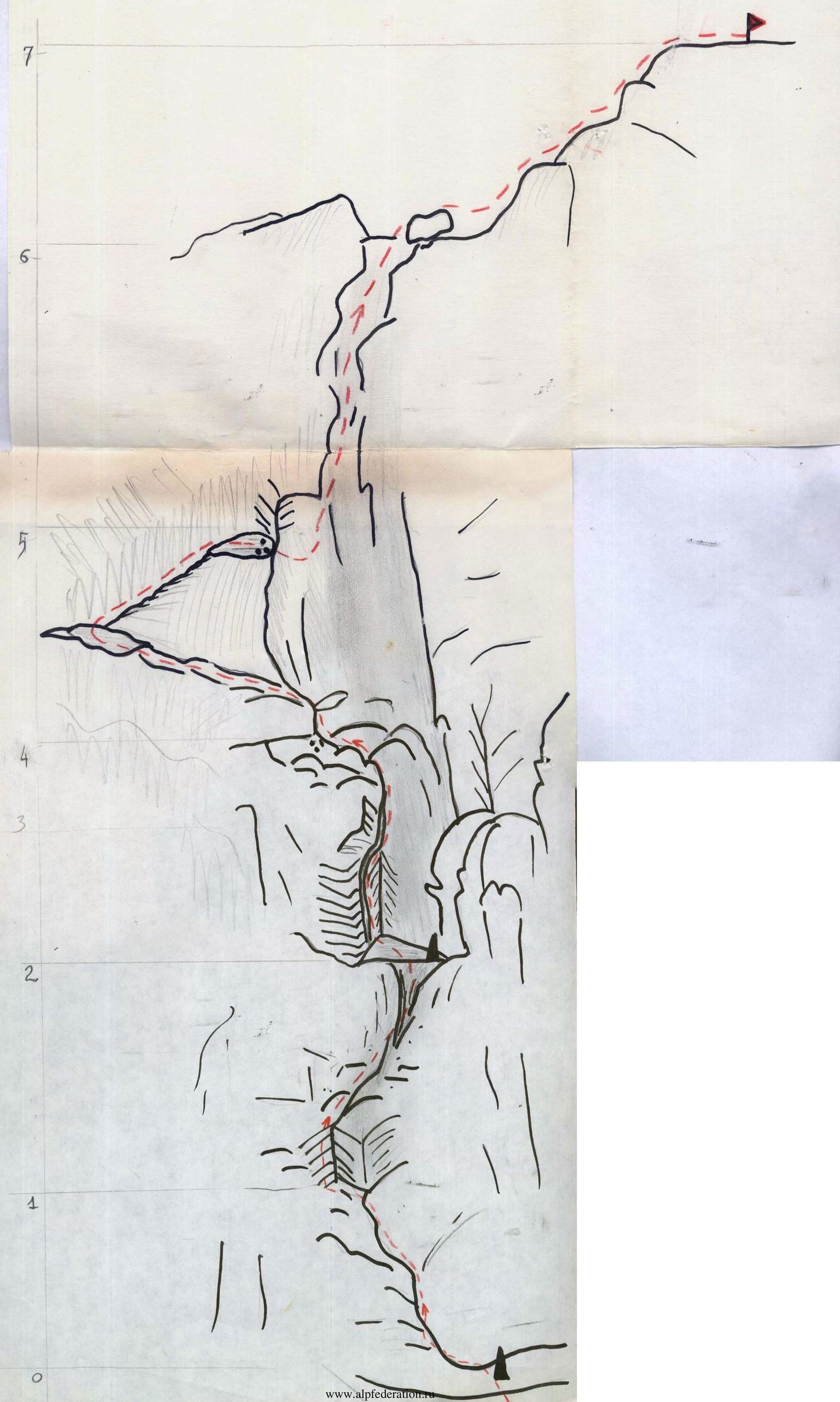
Table of Passed Sections
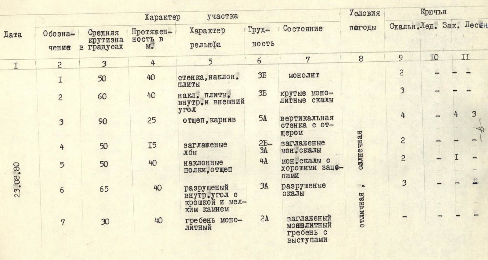
Explanation of the Table
Section R1
From the ledge with the signal cairn, go left and upwards for 15 m (sloping slabs), then climb a 5-meter wall at 90° and again left and upwards for 20 m along sloping slabs to a comfortable ledge. Climbing is of moderate difficulty; piton protection.
Section R2
From the ledge, go right and upwards for 20 m — sloping slabs, then a 5-meter internal angle, and further right and upwards along steep short walls to a well-defined chimney-cleft; climb 15 m up it and exit onto a good ledge visible from below as a recess (niche) in the wall. Control cairn. Piton protection. Climbing is moderate.
Section R3
Key location — a vertical wall with an outcrop, 90°, climbing is very difficult, piton protection, ladders; at the top, there is a slight overhang. The length of the section is 25 m.
Section R4
Climb smoothed "ram's forehead" left and upwards — 15 m. Climbing is easy; piton protection. Exit onto a ledge.
Section R5
Climb left and upwards along moderately steep rocks, interspersed with short ledges and good holds (20 m). Then, go right and upwards along an outcrop (20 m) — exit onto a comfortable ledge. Piton protection.
Section R6
Climb up a sloping, crumbling internal angle (loose small stones) — 40 m — exit onto a wide platform under the pre-summit ridge. Climbing is easy and moderate.
Section R7
Climb a smoothed monolithic ridge — 40 m. Exit onto the summit. Protection is via rock features and pitons. Descent is via a 3A category route. At the beginning of the season, there may be snow on the ridge, and cornices are possible. The ascent takes 3–3.5 hours; the route is rated 3B category; recommended for:
- sports groups;
- well-trained groups with good rock climbing skills.