
YAGNOBSKAYA STENA to the Western peak. Description of the ascent via the northern wall through the western shoulder with exit to the Western peak I.
Compiled by: (V. Tkachev)
Dushanbe — 1969
I. History of the region's exploration
If you travel to Dushanbe from Leninabad via the road passing through the Anzob pass, you will see a light gray, sharp peak visible from behind the surrounding mountains immediately beyond the Anzob village, up the Yaghnob river. This is the highest point of the Yagnobskaya Stena, its main peak.
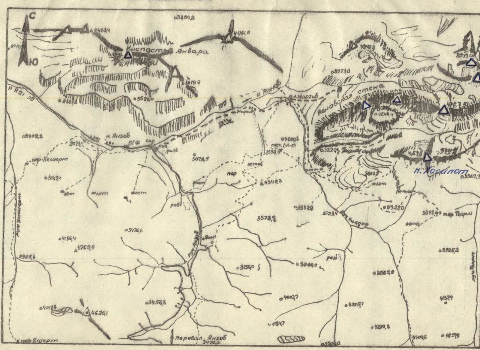
The Yagnobskaya Stena is located in the spurs of the Great Caucasus range and the Hissar range, in a local mountain system that includes eight peaks (diagram #1). In August 1967, while making an ascent to one of the peaks in memory of the deceased mountaineer Anvar Shukurov, climbers from the DSO "Khosilot" turned their attention to the massive wall array located opposite (6000 m).
Previous reconnaissance of the massif indicated a high technical difficulty of the routes along the entire length of the wall, requiring:
- high athletic skill of the climbers,
- special equipment that the society's climbers did not possess.
Therefore, in the long-term plan of the section, the exploration of this region was scheduled for 1969, with training camps held in the Fann Mountains in 1968 to improve the athletic skill of the society's climbers. The training was successful, and most participants met the standards for candidate and master of sports.
The ascent of the Yagnobskaya Stena was submitted by climbers from the DSO "Khosilot" for the republic's championship in 1969 as team #2. Team #1 had planned to submit an ascent of the most complex route on the wall for the USSR championship, but the inclusion of most of its members in the Tajikistan national team for the traverse of the Dugdond array forced them to abandon the ascent. Team #2 successfully completed the planned ascent.
As already noted, the Yagnobskaya Stena is located in a separate mountain system between the Great Caucasus and Hissar ranges, near the Yaghnob river. The total length of the wall is about six kilometers (according to the 1:100,000 map), with the crest oriented from east to west.
Height:
- Main peak (according to the map) — 4767.5 m
- Western shoulder of the wall, through which the ascent was made — 3910 m (according to the altimeter)
- Western peak I — 4100 m
 The base of the northern wall is marked at 2600 m (western part) to 3200 m (under the main peak), with a height of 900 m to 1500 m. The height difference of the southern slopes is 100 m (from the crest to the plateau) to 400–500 m (in the central part).
To the north, beneath the wall, lie small glaciers, the most significant of which is located under the main peak. The wall itself also features small hanging glaciers in its central part and individual snow and ice ledges on the western part. The overall steepness of the wall from the north is:
- Section I — 70–75°,
- Section 2 — 80–85°,
- Section 3 — 60–70°.
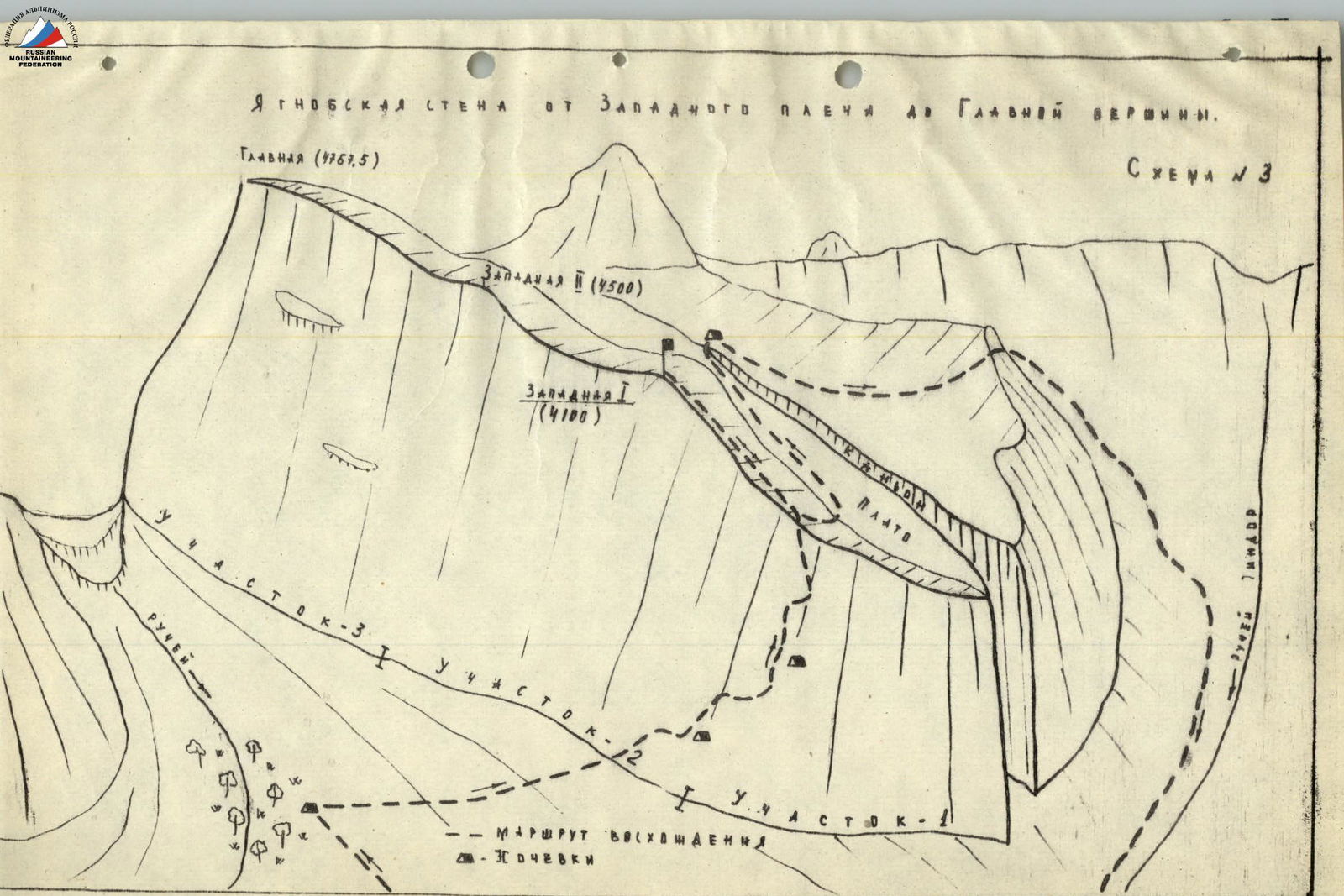
The rocks in Section I are quite rugged, while those in Sections 2 and 3 are smoothed. The division of the western part of the wall into Sections 1, 2, and 3 is shown in diagram #3.
From the south, in the western part of the massif, beneath the shoulder, lies a plateau (scree, gentle rocks) that drops into a canyon with walls 200–300 m high. The canyon extends almost 1/3 of the wall's length from the west (diagram #1). There are no glaciers to the south; only individual snow and ice couloirs exist. The steepness of the slopes ranges from 45 to 60°. The rugged terrain is generally smoothed in some areas.
To the west, the Yagnobskaya Stena drops off with heavily rugged and partly significantly destroyed rock walls with a steepness of around 80°.
East of the main peak, a detailed inspection of the wall was not conducted. An aerial view reveals a crest with a steepness of about 50°, descending into a neighboring valley (diagram #2).
From a sporting perspective, the northern walls of the massif are of the greatest interest. It can be noted that several routes of the highest category of difficulty are possible slightly west of the route taken, without the use of a significant number of pitons (Section I). Section 2 is likely impassable. Section 3 is passable with the use of a significant number of pitons.
An ascent to the Main peak from the west, from the shoulder, is also of interest, with a route of approximately IV category of difficulty, and from the east along the crest, with a route of approximately V category of difficulty.

IV. Composition of the ascent group
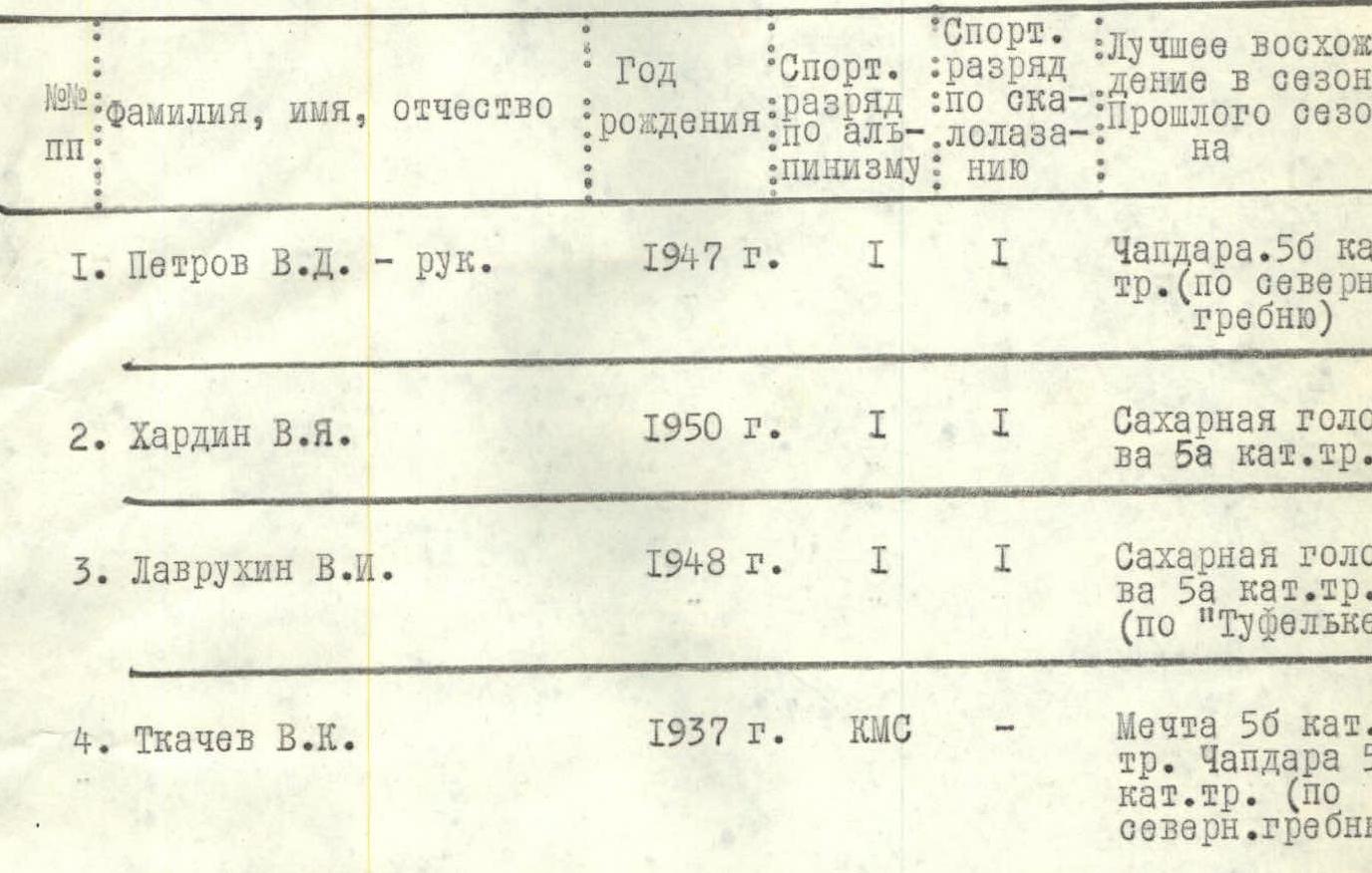
Observation group:
- Solovyova T.N. — Master of Sports
- Filippov A.K. — candidate for Master of Sports
- Khardin V. — 3rd sports category
- Tkachenko A. — 3rd sports category
V. Route description of the ascent
By car from Dushanbe to the bridge over the Yaghnob river, which flows at the foot of the Anzob pass, the journey takes about 3 hours. From the "Varzob" guesthouse, the duration of the trip is about 2 hours (orographic). From the bridge, a trail follows the left bank of the Yaghnob river, at the beginning of which the construction of a motor road is underway. The trail passing through the canyon has small overhangs but is generally wide and safe. The journey to the villages of Margib, located at the foot of the Yagnobskaya Stena massif, takes about 2 hours.
 Upon exiting the canyon, a majestic view of the western part of the wall unfolds, which, due to its height, appears to be looming over the village. The village is in the shadow of the wall, and the sun appears over it only at 11:00–12:00.
From the village, hunting and farm trails lead to the wall; the ascent is not complicated, although it is quite steep in the initial part. Beneath the wall lies a large inclined plateau, sloping from east to west, through which a large stream flows, surrounded by a forest of dwarf birches. It is most convenient to set up a camp here, from which almost the entire route is visible.
From the trail and camp, two snow and ice ledges on the wall of the western shoulder, through which the ascent is made, are clearly visible.
1st day. Section R0–R1. Departure at 6:00. The route begins on a snow and ice slope located at the foot of the counterfort. The approach takes 30–40 minutes.
The firm, especially in the morning, firn slope, partially turning into ice, has a steepness of 30–40° and a length of about 100 m. The altitude gain is around 40 m. Cutting steps is necessary on the icy sections. In the morning, the slope is not prone to rockfall, but by 11:00–12:00, it is periodically hit by small rocks and ice fragments.
The most difficult part of the section is the transition to the rocks. It is necessary to descend into the bergschrund by 10–12 m and climb out of it onto the rocky counterfort.
The group traversed this section almost in the dark and took about 1 hour. Insurance was provided through an ice axe.
Section R1–R2. From the snow and ice slope, a steep rocky counterfort rises. The rocks are marble-like limestone, monolithic, with occasional ice formations that can be bypassed. The route follows a vaguely expressed ridge of the counterfort, to the left of a band of iced rocks from the first snow ledge. The width of the counterfort is about 60 m, with a steepness reaching 80° in some places. The rocks are of medium and high difficulty, with an overall steepness of around 70°. Insurance is provided by pitons. There are several small ledges and platforms where one or two participants can be accommodated. The length of the section is 280 m (four 60 m ropes and one 40 m rope were used). The altitude gain is around 140 m. On one of the 60 m sections, a rope was used to pull up backpacks (steepness of 80°). The route along the ridge is logical; deviations are impossible due to smooth, sheer rocks on both sides. The movement is zigzag.
Installed:
- 25 rock pitons
- 5 ice pitons (in rock crevices)
The section is traversed by climbing without the use of artificial support points and leads to yellow rocks — overhangs, to a ledge where the entire group can be accommodated. On this ledge, the first control turret is broken. The passage of this section took 5 hours. Photographic materials for this part of the route are not included due to a lack of suitable points for photography.
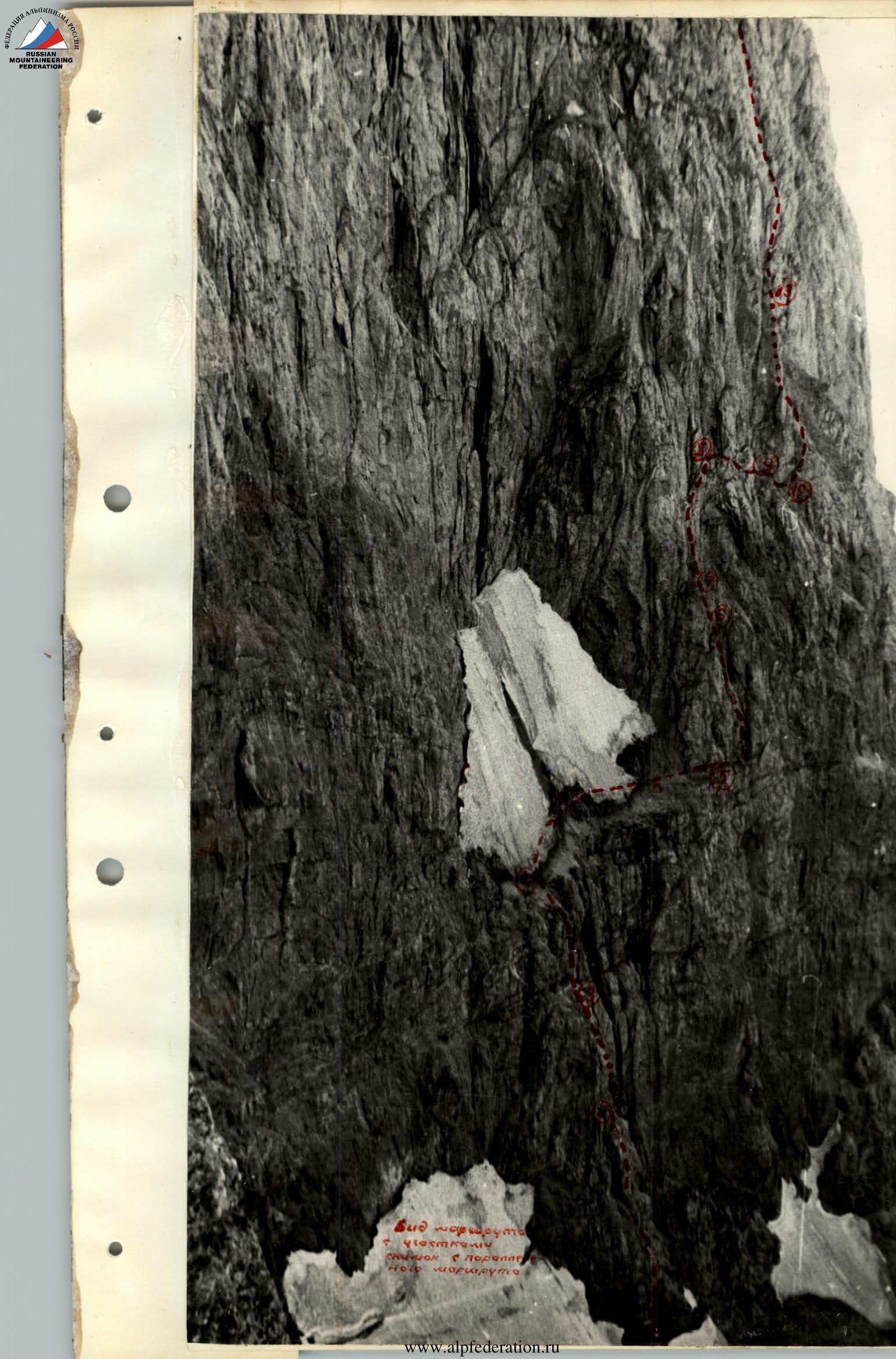
Section R2–R3 (photo 3, diagram #4). The overhang is bypassed on the right, with a double passage through a band of iced rocks. It is not advisable to go left — beyond the seemingly passable section visible from below lies an overhang.
From the ledge where the control turret is broken and a note with a description of the bypass route is left, it is necessary to climb onto a narrow, strongly inclined ledge located on smooth, sheer rocks, and then traverse right along it to a band of iced rocks. The width of this band is 6–10 m. Handholds, as well as crevices for driving pitons, are cleared of ice.
The route then proceeds:
- Up along the boundary between iced and dry rocks until it is level with the upper boundary of the overhang;
- From there, it crosses the band of iced rocks again to the left, entering a discontinuous crevice — a groove, partially iced, through which water flows.
When crossing the iced band in both directions, artificial support points must be used.
The crevice — groove (width 5–6 cm) leads to the top of the overhang, where there is a small ledge (for 1–2 people), which can be reached with a 60 m rope. Climbing is very difficult. In six places, artificial support points were used:
- Ladders with 2–3 steps.
For the group, a 10 m ladder was hung from the start of the second passage through the iced band. Backpacks are pulled up. The overall steepness of the section is around 80°. 15 pitons were installed, including one piton. The rocks are monolithic. The passage of this section took 4 hours. The altitude gain is 60 m.
Section R3–R4
The wall has an overall steepness of 70°, a length of 100 m, and an altitude gain of 60 m. Climbing is difficult. The direction of movement is to the right and upwards. After 30–40 m, small inclined ledges are encountered, where insurance can be organized. 18 pitons were installed. Deviations from the route are impossible — smooth rocks are found on both sides. The passage of this section took 2 hours 30 minutes. The section leads to the first snow and ice ledge.
Section R4–R5. A wide (up to 20 m) ledge filled with snow has a length of about 100 m. The route follows the lower part, where the ledge's inclination is 35–40°. Closer to the rocks, the steepness increases to 50–60°. Individual sections are traversed along the thawed edge of the rocks, covered with scree. Reliable insurance is difficult to organize — the ice protruding in some places is fragile and does not hold pitons well. Cutting steps is mandatory. The section is potentially rockfall-prone — a wall rises sheer above the ledge for 700–800 m, but there are few rockfall traces on the snow.
After 100 m, the ledge narrows sharply and turns into a clean, almost horizontal rock band, 30–40 cm wide. By 19:30, the group had gathered at the end of the snow and ice ledge. At the narrowing, a platform was cleared for a bivouac, and the remaining daylight was used to process a 60 m section of the route.
Section R5–R6. Departure at 8:00. The narrow ledge narrows further (see photo) and disappears after 50–60 m on sheer rocks. 5–6 m before its end, a discontinuous groove — a chimney — ascends vertically up the ledge. This is the most difficult section of the route; its length is 140 m (1 × 40, 1 × 60, and 1 × 40 ropes were used).
The wall, with an overall steepness of about 85° (individual sections are sheer and overhanging), is cut by a discontinuous, shallow groove, 8–10 cm wide, turning into a chimney in some places, into which it is difficult to squeeze. After 60 m, a platform is encountered where two people can be accommodated.
Features of the passage:
- The ascent is difficult and psychologically challenging — the wall above the ledge is overhanging.
- 25 pitons were installed.
- Backpacks are only pulled up.
- Time taken to pass the section — 4 hours.
- Other passable paths upwards do not exist.
Section R6–R7
The wall turns into a completely smooth slab, with a steepness of 45° and a length of 30 m. From the point where the wall turns into the slab, one piton can be installed. From there, it is necessary to traverse to the right, to a smoothed crack, invisible from below, along which it is possible to cross the entire slab to the left and upwards, and exit under an overhang. Only one piton is installed. The passage takes 1 hour.
Section R7–R8 (diagram #5).
The slab smoothly turns into an overhang, which is traversed along its left part, where there are cracks and crevices. The length of the section is 60 m, and the direction of movement is to the right and upwards. Climbing is very difficult; backpacks are pulled up. 12 pitons were installed, and ladders were used four times. The entire section is in shadow. A characteristic feature of this place is the yellow color of the rocks, unlike the gray color of the rocks along the rest of the route. This spot is clearly visible from below. At the top of the overhang, there are several small ledges where the third control turret is built. Directly under the turret, there is a triangular recess in the rocks, visible from below as a small cave.
The passage of this section takes 2 hours 30 minutes.
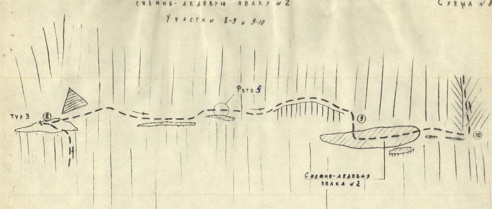
Section R8–R9 (photo 5, diagram #6). From the turret, the wall is traversed to the right along the route (20 m) to a bend. The rocks are of medium and high difficulty. 3 pitons were installed.
Beyond the bend, a partially discontinuous, vaguely expressed ledge, 5–10 cm wide, begins. The rocks are sheer, with negative slopes underfoot.
Insurance is provided by pitons — 4 pitons were installed.
The length of the section is about 40 m.
At the end, there is a descent down a 5–6 m sheer wall to the second snow ledge.
The passage of this section took 1 hour 30 minutes.
Section R9–R10 (diagram #6). The snow and ice ledge, 10 m wide, has an inclination of up to 40°. It is traversed with alternating insurance through an ice axe and partial cutting of steps. The length of the section is 30 m, and the time taken is 30 minutes.
Section R10–R11. From the end of the ledge, a groove — a couloir — with an overall steepness of about 60°, and a width of 30–50 cm, ascends to the left and upwards. The rocks are of medium difficulty and smoothed. The length of the section is about 100 m. Insurance is provided by protrusions and partially by pitons. 3 pitons were installed. The time taken to pass the section is 1 hour.
Transition from control turret #3 to snow and ice ledge #2
Sections R8–R9 and R9–R10
 Section R11–R12. The groove — couloir — ends with a small wall (5–6 m), down which water flows. The wall leads to a ledge covered with moss, partially with scree, and ascending to the left and upwards. The ledge is closed by an overhang; water flows along it, with a width of 20–30 cm and a steepness of 35°. Insurance is provided by pitons — 8 pitons were installed. The length of the section is 80 m, and the passage takes 1 hour 30 minutes.
Section R12–R13
The ledge, which narrows further to 5–10 m, leads to a rocky counterfort. The rocks are of medium and high difficulty, with a steepness of 70–75°. The length of the section is 65 m, and 8 pitons were installed. The route ascends logically in a zigzag manner. The time taken is 1 hour 30 minutes. The section leads to a wide, inclined ledge surrounded by overhanging walls. Here, the second bivouac is organized, and turret #4 is built. It should be noted that from the first bivouac to the present location, there are no suitable platforms for bivouacs. The ledge can accommodate a group of 4 people in a semi-reclined position.
3rd day.
Section R13–R14 (photo #5).
Departure at 7:00. The length of the section is 190 m (1 × 60, 1 × 60, 1 × 60 ropes were used), with a steepness of 70°. The rocks are of medium and high difficulty. The route is logical, ascending in a zigzag manner along a crevice starting from the left side of the platform. At the end of each rope, small, strongly inclined ledges are encountered, where 1–2 people can be accommodated. 26 pitons were installed. Backpacks on the first and second ropes are pulled up. At the end of the section, there is a small 10 m traverse to the left and then 15 m straight up — a rock wall of medium difficulty, with a steepness of 70°. The wall leads to a balcony where a bivouac can be organized. Here, control turret #4 is located. The time taken to pass the section is 6 hours. It is advisable to traverse this section as early as possible — there are traces of falling rocks.
Section R14–R15 (photo #6).
From the balcony, to the right along the route, there is a horizontal transition along a ledge, 15–30 cm wide, to the beginning of stepped rocks of a giant groove descending from the crest of the wall. The rocks are easy and of medium difficulty. Insurance is provided by protrusions and pitons — 3 pitons were installed. Further, it is not advisable to go 60 m to the right — the initially easy path leads to heavily smoothed, difficult-to-traverse rocks.
Section R15–R16.
The giant groove, 60–70 m wide and with a steepness of 60–65°, is composed of stepped rocks (8–15 m). The rocks are of medium difficulty. The overall length of the section is about 400 m. After 20–25 m, there are platforms for accommodating the group. Insurance is provided by pitons — 20 pitons were installed. The route is logical, following the left side of the groove, which is less prone to rockfall. The direction of movement is to the left and upwards; the groove leads to the crest of the wall, to the shoulder with an elevation of 3910 m, where a turret is built. The time taken to pass the section is 5 hours. The group reached the crest at 18:00. Here, the fifth turret is built.
Section R16–R17.
The path to Western peak I follows the crest. It is impossible to bypass to the right. The rocks are of medium difficulty and easy, with an overall steepness of about 45°, and up to 60° in some places. Insurance is provided by pitons and protrusions. Backpacks can be left at the turret, significantly increasing the group's movement speed. Two gendarmes on the crest can be bypassed on both sides and do not present difficulties. The overall length of the section is about 300 m, and the time taken to ascend is 1 hour 30 minutes. 10 pitons were installed.
Western peak I is a vaguely expressed, gently sloping, wide (up to 15 m) section of the crest, covered with rock fragments, where a turret is built.
The descent to the backpacks along the ascent route takes 1 hour. From there, it is about 60 m down easy rocks to the scree, and then along the scree, under the rocks of the southern slopes of the wall, bypassing the canyon (in this place, a section of slabs, 100 m long), and exiting to water, where a bivouac is organized. The descent from the crest to the bivouac took about 2 hours.
4th day. Return.
From the bivouac, it is necessary to ascend the left (along the route) slope and cross a small crest, dropping off steeply to the west. By heading strongly south, it is possible to find a passage between the rocks and descend into the valley of the main river, along which a wide trail runs, bypassing the western slopes of the Yagnobskaya Stena and leading to the Margib village, from where the familiar path returns to the Dushanbe — Leninabad road.
The entire journey from the bivouac to the road takes 4–5 hours.
VI. Additional information on the route
Communication with the observation group is possible using a flashlight — the entire route is visible from the bivouac under the wall. It is advisable to make the ascent no earlier than August — earlier, the number of iced rocks will be significantly higher, making the route more challenging. However, icing will also depend on the amount of snow fallen in the winter and the temperature of the summer months, i.e., the intensity of melting. In August, an ascent without a tent is possible. An early start on the route is necessary. Bivouacs are only possible on ledge #1, under the overhang (bivouac #2), on the balcony (turret #4), and higher. This should be taken into account when planning the movement schedule. It is cold on the route — the sun does not appear on the wall until 14:00–15:00. The entire route is very logical — deviations are impossible.
Several different variants of ascent are possible after the balcony (turret #4):
- Parallel to the giant groove;
- Exit to the crest at a distance of about 100–150 m.
The variants are roughly equal in difficulty.
It is mandatory to traverse the route in helmets — although rockfall was not observed during the group's movement, traces of falling rocks were found on some sections.
VII. Equipment
The group had the following main equipment, which is recommended for subsequent groups with 4 participants.
- Main rope 2 × 60 m.
- Auxiliary (expendable) rope — 10 m
- Hammers — 2 pcs.
- Ice axes — 2 pcs.
- Titanium pitons — 30 pcs. (horizontal, vertical, and universal).
- Duralumin wedges — 5 pcs.
- Ice pitons — 5 pcs.
- Carabiners — 25 pcs.
- Pitons — 5 pcs.
- Ladders with 3–4 steps — 5 pcs., 10 m ladder — 1 pc.
- Helmets — for all participants.
- "Pamirka" tent — 1 pc.
VIII. Category of difficulty
Comparing the route with previously traversed routes of 5B category of difficulty on the peaks "Mechta" and "Chapdar", the following can be noted:
-
The length of the difficult climbing sections of the traversed route is the same as that of the route on "Mechta", but slightly longer than the sections on "Chapdar".
-
In terms of the overall route length (vertically), it is roughly equal to the routes on "Mechta" and "Chapdar".
-
In terms of the difficulty of the most challenging sections — slightly easier than the "Book" of Mechta (10 m internal angle with an overhang), but harder than the sections on "Chapdar".
-
In terms of the overall steepness of the route and psychological difficulty, it is harder than "Mechta" and "Chapdar".
The route is also harder than all traversed routes of 5A category of difficulty ("Mechta", "Moscow", "Sugar Head" ("Tufelke")).
Based on the above, the group evaluates the traversed route as 5B category of difficulty.
Table of main characteristics of the ascent route
Number of travel hours — 44. Route altitude gain — 1170 m. Route length — 2195 m. Wall altitude gain — 980 m. Route steepness — 70°.
| Sections: steepness | Length in m. | Section characteristics: By relief character | By technical difficulty | By method of overcoming | Stops at bivouac | Time: departure | Travel hours | Pitons installed: Rock | Ice | Pitons | Bivouac conditions |
|---|---|---|---|---|---|---|---|---|---|---|---|
| 1st day | |||||||||||
| R0–R1 40° | 100 | Snow and ice slope | Easy and medium difficulty | Steps, ice axe | – | 5:30 | 1.0 | – | – | – | – |
| R1–R2 70° | 280 | Monolithic rock wall | Medium and high difficulty | Free climbing, piton insurance | – | – | 5.0 | 25 | 5 | – | – |
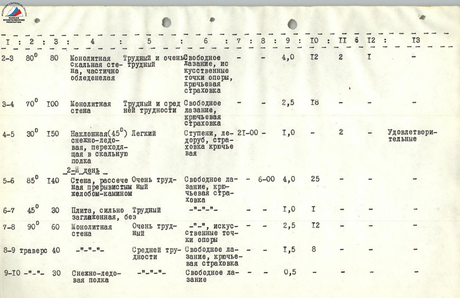
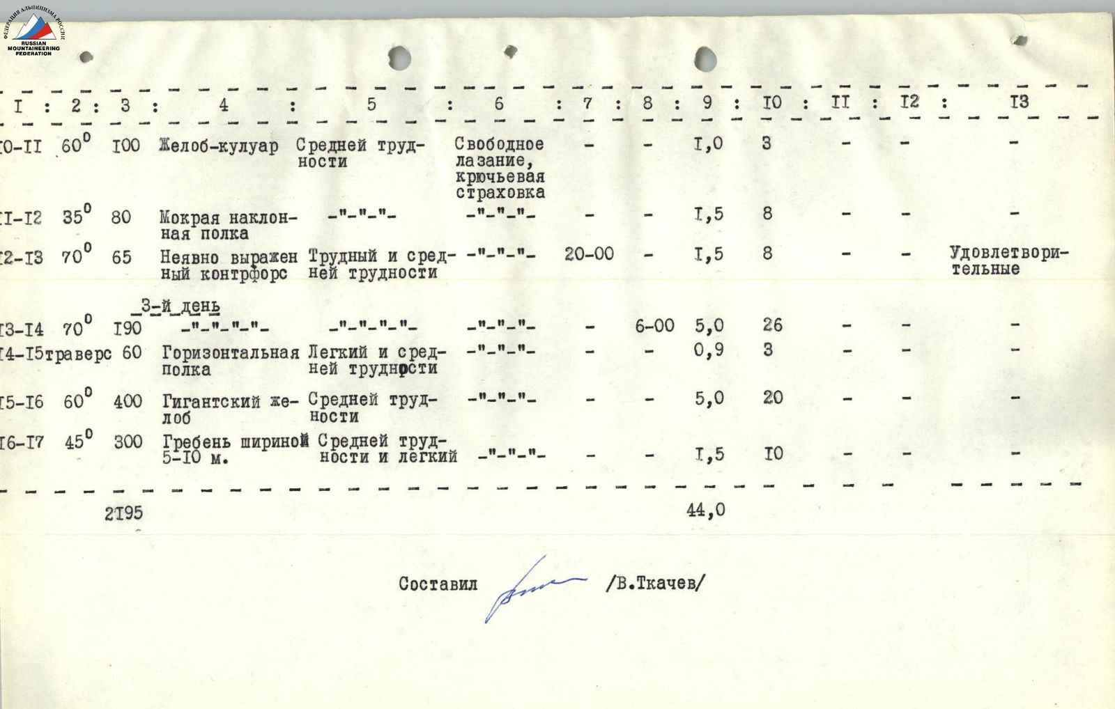
| Sections: steepness | Length in m. | Section characteristics: By relief character | By technical difficulty | By method of overcoming | Stops at bivouac | Time: departure | Travel hours | Pitons installed: Rock | Ice | Pitons | Bivouac conditions |
|---|---|---|---|---|---|---|---|---|---|---|---|
| R2–R3 80° | 80 | Monolithic rock wall, partially iced | High and very high difficulty | Free climbing, artificial support points, piton insurance | – | – | 4.0 | 12 | 2 | 1 | – |
| R3–R4 70° | 100 | Monolithic wall | High and medium difficulty | Free climbing, piton insurance | – | – | 2.5 | 18 | – | – | – |
| R4–R5 30° | 150 | Inclined (45°) snow and ice, turning into rock ledge | Easy | Steps, ice axe, piton insurance | 19:30 | – | 1.0 | – | 2 | – | Satisfactory |
| 2nd day | |||||||||||
| R5–R6 85° | 140 | Wall cut by discontinuous groove-chimney | Very high difficulty | Free climbing, piton insurance | – | 6:00 | 4.0 | 25 | – | – | – |
| R6–R7 45° | 30 | Slab, heavily smoothed, without | High difficulty | – | – | – | 1.0 | 1 | – | – | – |
| R7–R8 90° | 60 | Monolithic wall | Very high difficulty | Artificial support points | – | – | 2.5 | 12 | – | – | – |
| R8–R9 traverse | 40 | – | Medium difficulty | Free climbing, piton insurance | – | – | 1.5 | 8 | – | – | – |
| R9–R10 – | 30 | Snow and ice ledge | – | Free climbing | – | – | 0.5 | – | – | – | – |
| R10–R11 60° | 100 | Groove-couloir | Medium difficulty | Free climbing, piton insurance | – | – | 1.0 | 3 | – | – | – |
| R11–R12 35° | 80 | Wet inclined ledge | – | – | – | – | 1.5 | 8 | – | – | – |
| R12–R13 70° | 65 | Vaguely expressed, difficult and medium counterfort | – | – | – | – | 1.5 | 8 | – | – | Satisfactory |
| 3rd day | |||||||||||
| R13–R14 70° | 190 | – | – | – | – | 6:00 | 5.0 | 26 | – | – | – |
| R14–R15 traverse | 60 | Horizontal ledge | Easy and medium difficulty | – | – | – | 0.9 | 3 | – | – | – |
| R15–R16 60° | 400 | Giant groove | Medium difficulty | – | – | – | 5.0 | 20 | – | – | – |
| R16–R17 45° | 300 | Crest, 5–10 m wide | Medium and easy difficulty | – | – | – | 1.5 | 10 | – | – | – |
| 2195 | 44.0 |
Compiled by (V. Tkachev)