Gissar Range
Zamin-Karor (Yaghnob Wall)
Western shoulder
3910 m
ASCENT VIA NW WALL THROUGH THE CAVE, CATEGORY 5B diff.
GROUP COMPOSITION:
- GRUSHEVSKY V.G., 1st sports category, "Khosilot" (team leader) (Dushanbe, Ziv Airport, 4)
- KASINSKY V.V., 2nd sports category, "Khosilot"
- LEONOV K., 2nd sports category, "Khosilot"
- SOLOVYOV M.A., 2nd sports category, "Khosilot"
Tajik SSR, Dushanbe
1974

Section #5. Exit from the chimney.
Section #8.
Brief geographical description
Of the region
When traveling along the Dushanbe-Leninabad road, after descending from the Anzob Pass, one cannot help but notice a light gray peak rising above the surrounding mountains along the Yaghnob River. It is characterized by sheer walls dropping north into the Yaghnob valley. The grand peak makes a great impression. Locals call it Zamin-Karor, which translates to "Calm land". Among mountaineers, it is widely known by another name - Yaghnob Wall.
Zamin-Karor is connected to the main watershed of the Gissar Range by a relatively high but heavily eroded ridge, on which lies a peak striking for its beauty and grandeur - Peak Khosilot, 4626 m high. To the north of the Yaghnob Wall are individual distinct peaks reaching 4000 m.
Along the entire northern foot of the Yaghnob Wall, a narrow strip of glacier is located. A characteristic feature of the region is the presence of individual distinct peaks. The rocks are composed of marbleized limestones, some of which are heavily smoothed. To the north, the peaks drop with sheer and overhanging monolithic walls; to the south, the slopes are more gentle.
Climatic conditions are similar to other regions of the Gissar Range and the Fann Mountains. In late September - early October, the usually stable, sunny weather gives way to snowfalls and cold winds.
Administratively, the region belongs to the Ayni district of the Leninabad region of the Tajik SSR.
Brief description of climbing conditions
In this region
Overall, climbing conditions in this region should be considered favorable, both in terms of climate and route conditions.
The western part of the Yaghnob Wall is characterized by steep, often smoothed rock walls. The routes are completely free of ice and snow; only small patches serve as water sources during ascents.
The eastern part of the Zamin-Karor massif is characterized by:
- heavy glaciation;
- snow cover.
Approaching the western part of the massif from the Dushanbe-Leninabad road takes 3 hours. From the road bridge over the Yaghnob River to Dushanbe is 100 km, and to the "Varzob" alpine camp is 48 km.
From the bridge, a pack trail follows the left (orographic) bank of the Yaghnob River upstream. Below the western part of the massif lies the village of Margib. It has telephone connection with the village of Anzob, and through it with Dushanbe.
Description of the route by days with a brief description of the path traveled
It should be noted at the outset that the route traversed by the group is not a first ascent. This route was first climbed in 1973 by a team from Nurek as a training ascent before participating in the USSR Alpine Championship. The team climbed the route in poor weather conditions. According to the participants - Lavrushin, Kapitanov, Yaroslavtsev - the route corresponds to category 5B diff., but for unclear reasons, the description was not submitted for classification.
In 1974, this route attracted the attention of the Central Sports Council of the "Burevestnik" sports society and the special forces team of alpinists from NarynGESstroy. Its participants (3 groups), which included prize-winners and champions of the USSR in rock climbing, rated this route as category 5A diff., noting in particular:
- the difficulty of the key sections (above 5A);
- the overall psychological complexity of the route.
Our group participated in the Alpinada of the Sports Committee of the Tajik SSR.
The route was chosen on the recommendation of the head of the CPS and the leader of the gathering, S.N. Sogrin, to:
- verify the category of difficulty;
- compile a description for classification,
which for unclear reasons was not done by the previous groups.
We started the route on August 18, 1974, as by this time observers and the entire team had gathered at the base camp. We began the route at 7:00.
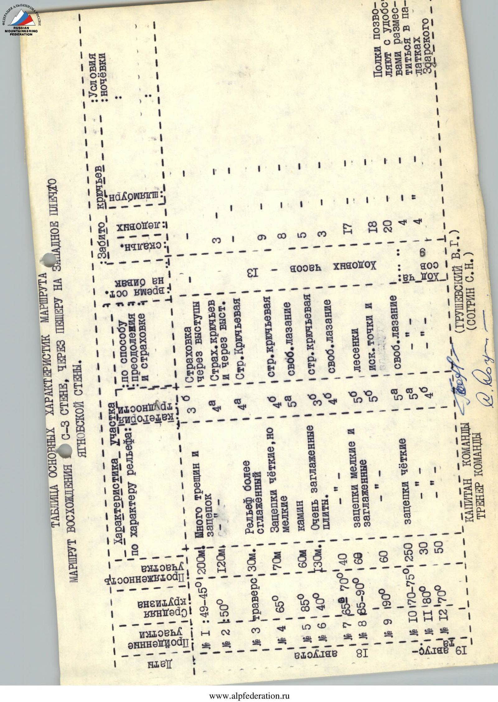
Section R1
The start of the route is from the snow tongue upwards, into a couloir formed by the wall and a rock outcrop, filled with snow and stones. The approach through the couloir is to the "finger" and绕 it to the right via simple rocks. Then, via moderately difficult rocks, we reach an osypnaya (scree) shelf. Protection is via rock outcrops. The length of this section is 200 m. The overall steepness is 45°–50°.
Section R2
From the shelf, via несложным скалам (easy rocks) - exit under a wall with a steepness of 60° and heavily smoothed relief, 60 m long. Protection is via rock outcrops, partly via pitons. The total length of R2 is 120 m. 3 rock pitons were hammered. Exit onto a narrow inclined shelf.
Section R3
Along the inclined, partially interrupted shelf - traverse right for 30 m. Piton protection. 3 rock pitons were hammered.
Section R4
Upwards along the light gray wall, 30 m of difficult climbing. Steepness 65°. Then, via moderately difficult rocks - move right, upwards under the next 60 m wall. Piton protection. The total length of the section is 70 m. 9 rock pitons were hammered.
Section R5
Upwards along the wall. Ten meters of difficult climbing lead into a vertical chimney 15 m long. Further movement is upwards via difficult rocks. Piton protection. The length of the section is 60 m. 8 rock pitons were hammered.
Section R6
Move right and upwards under the red rocks via a large inclined shelf, which is a smoothed slab. Steepness increases from 35° to 50°. Piton protection. Length 130 m. 5 rock pitons were hammered.
Exit to a large black niche.
Section R7
From the niche, left and upwards along a wall with a steepness of 65°–70° - exit into a cave. The wall is a monolithic slab with narrow cracks. Pitons enter poorly. Length 40 m. 3 rock pitons were hammered. There is a cairn in the cave.
Section R8
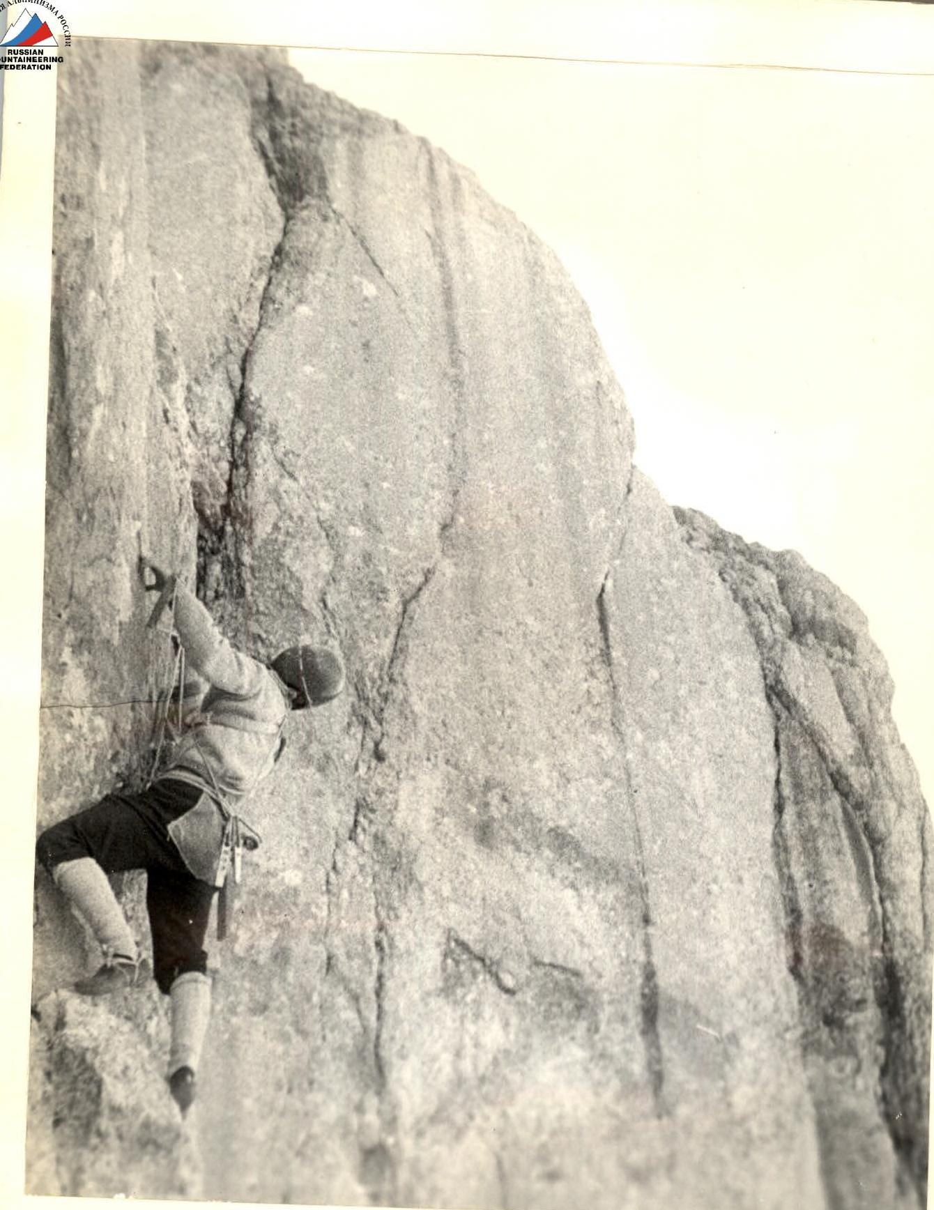
The start of the key section. From the cave - a short traverse left. Then upwards along a crack, and following it, move right and upwards.
The crack is clear and continuous but is clogged in many places. Steepness 85°–90°. Handholds are small and smoothed. Climbing is difficult. Artificial holds and ladders are frequently used. Piton protection. Backpacks are pulled up.
The length of the section is 60 m. 17 rock pitons were hammered.
Section R9
Continue moving upwards and right until reaching a completely monolithic gray wall without cracks or handholds. At this point, start traversing right with a slight gain in height. Climbing is very difficult; artificial holds and ladders are used. The traverse leads to a large niche in the red rocks. From the niche, straight upwards through an overhang and then along the wall - exit onto a shelf. This part of the section is climbed using ladders. Due to the difficulty of the section for rope passage, it is advisable to traverse left along the shelf and drop a free rope vertically. The length of the section is 60 m. Steepness 90°. 18 rock pitons were hammered.
Section R10
The section consists of alternating short walls (15–20 m) with short shelves or small platforms. There are no notable landmarks or features. Choosing the most logical path, we exit onto the ridge not far from the summit, before a red wall 30 m high. In the middle of this section, due to the onset of darkness, we made an overnight stop. The platforms do not allow for tent placement, but Zgarsky tents are very convenient for overnight stays. The overall steepness of the section is 70°–75°; vertical walls 15–20 m high are not uncommon. Piton protection. 20 rock pitons were hammered.
Section R11
Upwards along the wall, climbing is difficult. Handholds are very small but not smoothed. Piton protection. The length of the section is 30 m. 4 rock pitons were hammered.
Section R12
Along the ridge, via rocks of category 4-5 - exit onto the summit. Piton protection. The length of the section is 50 m. 4 rock pitons were hammered.
To the south from the summit, steep scree slopes descend. Without losing height, it is necessary to traverse left to a rock buttress. After crossing it, begin descent downwards and left, descending into the second scree couloir. Then downwards along a trail following a stream to the village of Margib.